Thursday, November 30, 2006

Fahnestock Memorial State Park - Hudson Valley NEARA fieldtrip


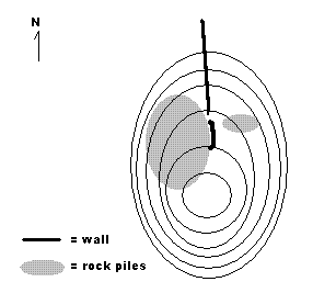
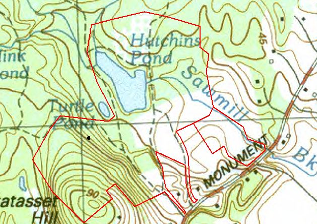
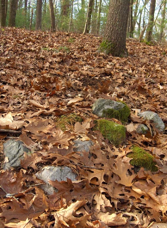
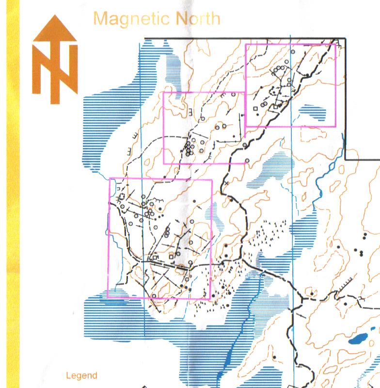
NEARA took a field trip to the Clarence Fahnestock Memorial State Park to look at the cairns there. Ann Banks (who was the NEARA coordinator for Massachusetts) sent me some photos and I am re-printing a portion of Robert Buchanan's trail map [I was not able to contact Mr. Buchanan to ask permission to use his map, so I hope it is OK to use a small part of it.] Cairns are indicated on the map by small circles with a dot in the center; stone walls are indicated by straight black lines with dots.

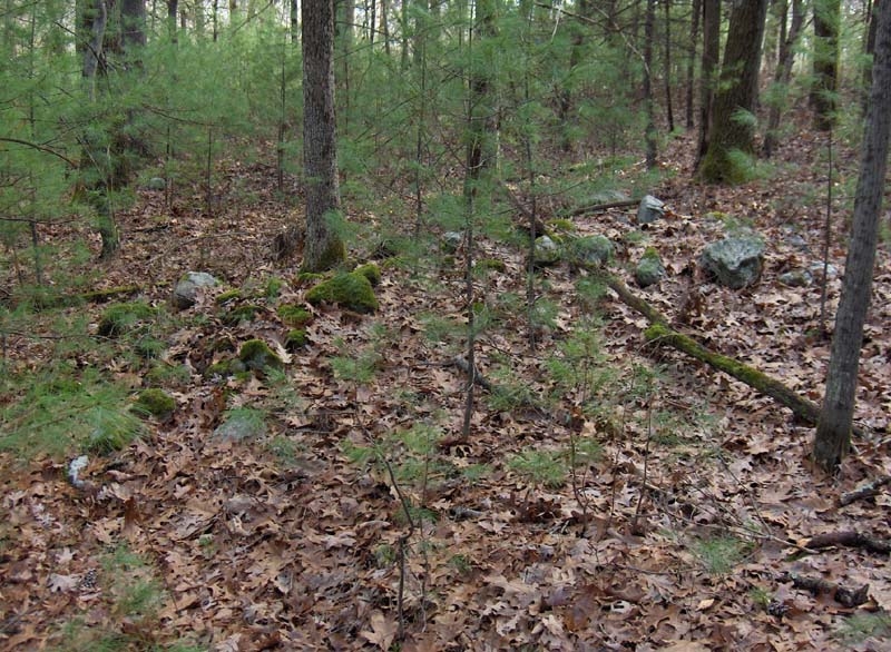
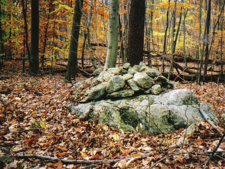
Here are some of the pictures Ann took:
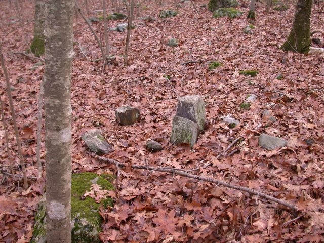
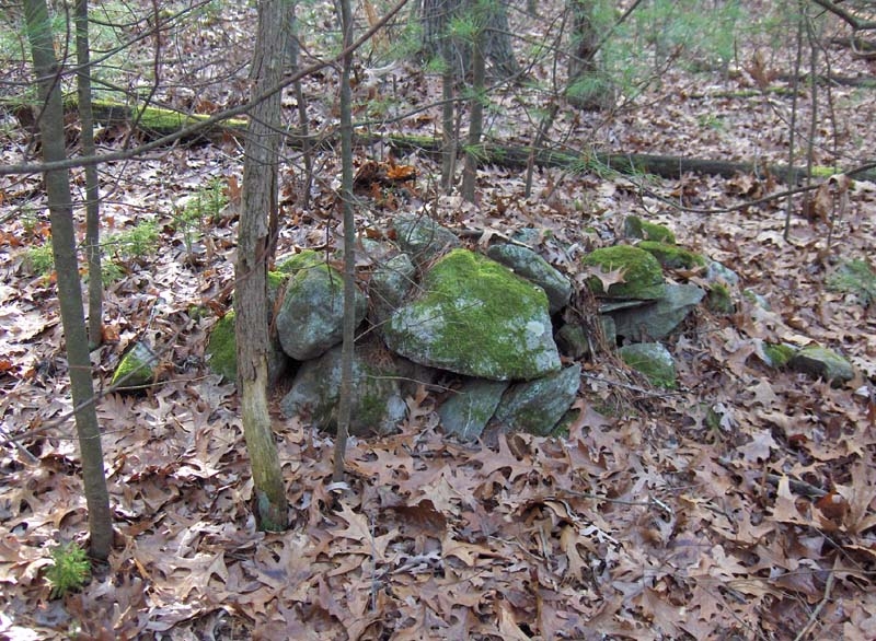
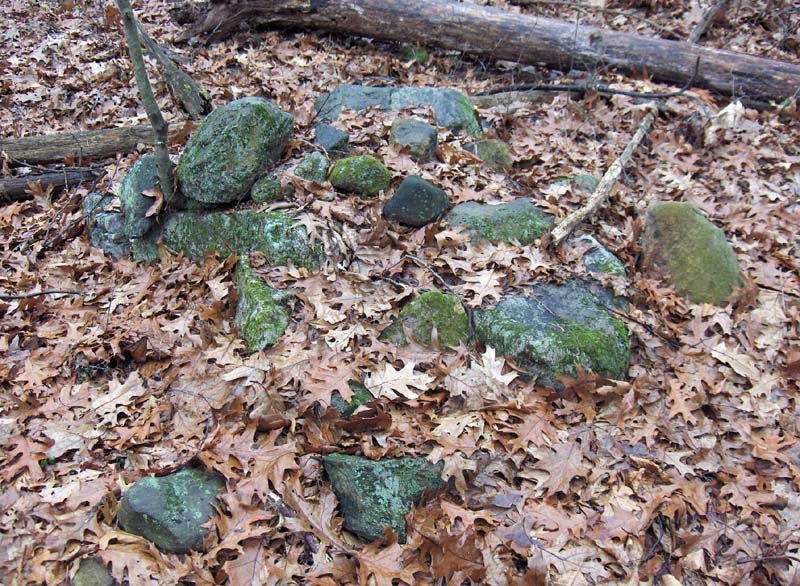
Here is an example of a stone wall joining boulders. This is the kind of feature which Norman Muller emphasizes and which we have also seen examples of from Jim Porter and Larry Harrop. In fact this site is very reminiscent of the places they show from Rhode Island.
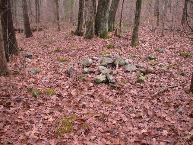
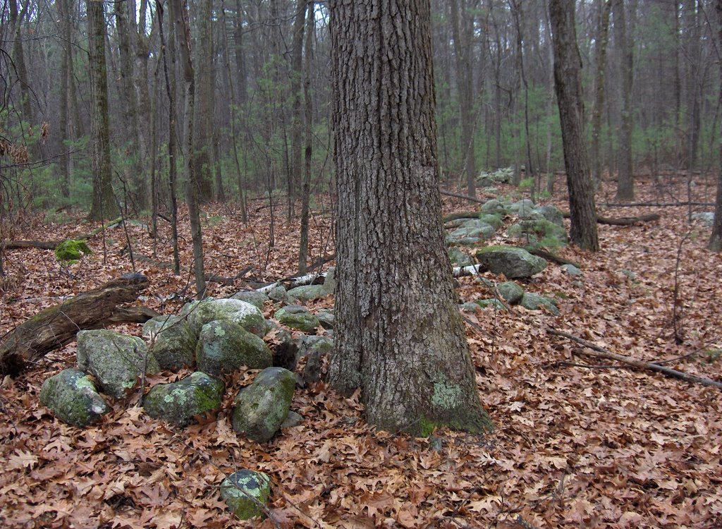
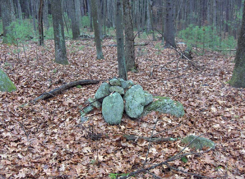
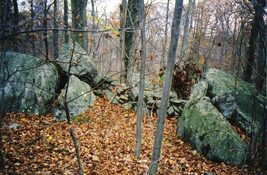
Also here is a short segment of wall, something I have been noticing lately at some of the sites I reported this week.
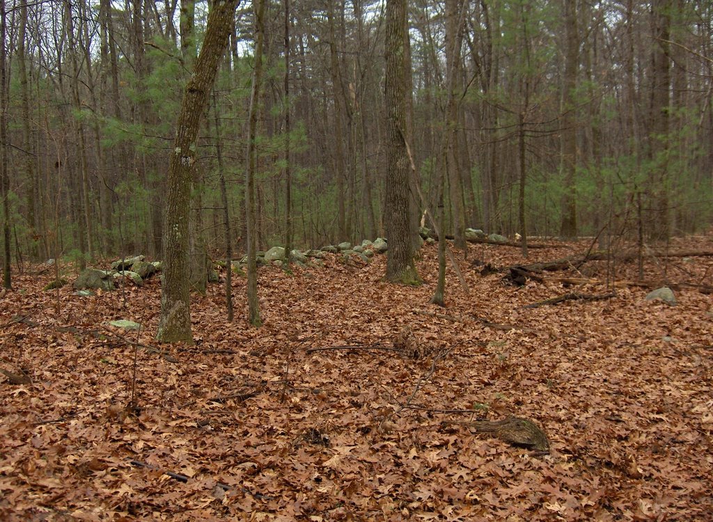
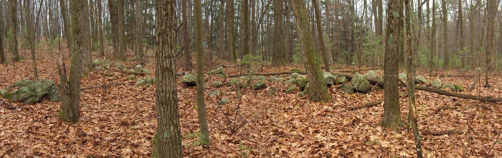
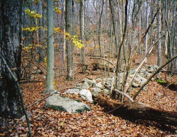
So, I hope to pay more attention if not to all walls near a site at least to these short segments. Looking more carefully at the map above, there seem to be lots of short segments like this at the site.

Encircled Rock Pile - from George Patterson

A hunter, George Patterson, filed a NEARA site report for a site in Westboro he noticed while out in the wood. Here is his site description:

Several years ago, while bow hunting, I noticed a circular mound of rocks. The mound is less than 2-3 feet tall and less than 10 ft. across. Additionally, there is a circle of larger rocks around the mound. The stone circle may be 20 -25 ft. across.
This structure is located at the bottom ( east side ) of a hill on the edge of a swamp. There is a stone wall running diagonally down the hill. The stone wall ends at the bottom of the hill and near this mound .

In addition, George email'ed me some photos of the site.
I think the following photos are different views of the mound surrounded by a circle.
It is hard to photograph these things but I think I can see a circle of stones around the central rock pile.

Wednesday, November 29, 2006

Stow, MA Developer versus NATHPO

Tim Fohl forwarded this link to me. It is about the Stow, MA development going on over by Delaney Street and uphill from there.[Click here]

Also check out the headlines about Sacred Sites. [Click here]

Tuesday, November 28, 2006

A Hill in Wayland - the flanking wall(s)

For comparison with the Punkatasset site, here is another not very accurate diagram of the layout of the hill, the rock piles and the broken stone wall at the site of the previous post.Here is the wall running downhill to the north
And here is the short slightly curved extension (looking at it from the east)
So I guess I should routinely pay more attention to the details of the wall layouts near sites.

A Hill in Wayland, MA - the rock piles

... I went across and followed the path a few twenty yards around to the north of the hill and then I angled up the slope through the saplings to discover rock piles all over the northern side of the hill. They were mostly non-descript oval ground piles, with some occasional signs of stacking, hints of piles with lighter rocks or redder rocks but nothing obvious.Here some of the piles seemed to incorporate quartz but only as one of several geologically interesting stones. In the first picture above, look at the veins in the central rock of the pile. Consider also these:Some other piles:
Near the upper limit of the site was a wall running down hill to the north. At the higher end was a separate "comma" of extension to the wall. I'll write about this in the next post.

Most of these piles were on the northwestern and northern slope. There were also a few piles on the northeastern slope:
Here we are in Wayland in a heavily suburbanified area and here are these neat remnants of Native American ceremonialism. It is just un-believable. On the other hand, there was something dream-like and timeless about the moment this morning where I was pushing my way uphill through the saplings and started to see rock piles.

Ozark Highlands Trail Association - Williams Woods

Cognitive Dissonance:

"The trail passes just above the cistern, then eases on down the hill a little away from it. You will begin to notice piles of rock out in the woods along the trail. Usually, folds would clear their fields of rocks and build walls with them. They needed to get the rocks out of the way so that they could plow the ground. I’m not exactly sure what happened here, but the rocks were simply put into piles instead of building walls with them. The trail does pass next to a small wall in this area, but most of the rocks are in piles. It certainly was easier to just pile them up, but I wonder if there was another reason. We will see some nice rock walls in a bit."
[Click here]

Monday, November 27, 2006

Punkatasset Hill - the stone walls (continued from previous post)

One important feature of the site was the way it was bordered by stone walls. I want to emphasize this here so as to be able to reference it later when I discuss a similar site in Wayland.

These walls all were fragmentary, in short connected stretches but not forming corners. Here is a not very good or accurate diagram of the walls, but I hope it gives the idea.
Here is a view of two nearby stretches of wall. Then details of each segment separately:
There were two other stretches above the site, sort of the southeastern extremity of the rock pile area. So that means walls along the western and along the southeastern edge of the site.. I am not prepared to classify this site. It seems more like a memorial site, with all the burnt rock in the piles. When I called FFC up to share my excitement about the site, and mentioned all the burnt rock, I mentioned ceremonial fires being built with rocks, and with the rocks later being incorporated into rock piles. And FFC brought up sweat lodges and the possibility that burnt rocks from the sweat lodge could have been used to make rock piles, as an extension of the activity. Also given the unusual wall stretches, I should get the compass boys out to make some measurements.

It is also noteworthy that this site is very similar to the XXX Hill site. It had at least one path running through the site and the path passes through a gap in the stretches of wall shown immediately above. Here is the trail as it passes the gap between two stretches of wall.
This is virtually identical with the entrance to the XXX Hill site. As soon as you pass the wall the rock piles begin.

Punkatasset Hill - the rock piles (continued from the previous post)

Here is the chronological description of the site:

As I approached the site, there was a bit of a gully with a split-wedged rock so I was thinking - "well at least there was some ceremonialism". But I did not expect to see a big rock pile site here for two reasons. One is that I explored Punkatasset years ago [apparently not very thoroughly or competently] and being near the center of Concord I thought this hill would have long ago lost any ceremonial features. Anyway, here are some shots of the gully, this is on the eastern side of the hill:Although the split-wedged rock is typical, especially in a wet place like this, there were two short stretches of stone row inside the gully which I thought were interesting. One next to the wedged rock, the other shown in this photo:
I thought that was all I was going to see on this hill and could not decide whether to bother photo'ing this minor pile made from burnt rock.
But soon I was into an area of many piles and forgot about my doubts. I rushed around taking pictures. This one caught my eye for the obvious reason [it was not a fire ring, there were other rocks in the center covered over by leaves and there was no sign of char]:
There were some typical non-descript ground piles. Some had more obvious burnt rock in them but only a few had noticeable quartz in them. Like this one. What is prominent is the black rock at the center, quite different from a white rock at the center:Although there were more ground piles than anything else, I tended to focus more on the supported piles. These appear to have been decent sized "cairns" before they were brought down by falling trees, passing teenagers, etc.Here, for example is the solitary pile Nick Holland sent me a picture of. Except it is not at all solitary. And here is a detail, showing the burnt rocks incorporated at the center of the pile:Here is a pile I groomed slightly. A "pile in motion" showing how it was knocked over:
[DIGRESSION: I am becoming more aware of pile damage. In many cases you can see a "vector" of damage, as if the thing got bashed from one side. Here in the last photo you can see rocks scattered to the right of the pile. Let's call that a rock pile "in motion".]

In the next post, I want to discuss the stone wall segments which flanked the site.
*****************[To be continued]*******************

Punkatasset Hill - Concord, MA

(I am making this site public following the guideline which permits identifying sites which are already in plain view and already badly damaged.)A reader of my blog named Nick Holland wrote me mentioning seeing a solitary rock pile on the northern slope of Punkatasset Hill in Concord, so since it was only a short drive, I have been saving it for a short walk. Today, Thanksgiving, seemed like a perfect day for it. After getting the bird in the oven I went over to look for the solitary pile. There is another solitary pile not too far away in Estabrook woods and I figured these might be two examples of boundary markers. But when I explored today It turned out there are about 100 piles over there on the north slope of Punkatasett Hill and it turns out to be the largest site in Concord with piles more like cairns than anything else I have seen. What a surprise seeing new piles in Concord! I called FFC with excitement and he said he already knew the place and assumed I knew about it. Well I tell you, finding another major site in Concord is a cause for great celebration.

The black dot on the map right below the "d" in "Turtle Pond" is about the lowest pile on the slope. They continue uphill for 100 yards covering an area of several acres. I could not get over my surprise at seeing so many new piles in Concord. My first reaction is captured a bit by this video clip:


And then I wanted to take a panorama to show the pile density:
I walked around criss-crossing the site trying to understand its size and nature. Mostly it consisted of ground piles with a few burnt rocks. But there were also larger boulder supported piles, which also contained bits of burnt rock.
***************************[to be continued]***************************

Summary of the weekend's finds

I hope to roll out descriptions for two sites I found over the weekend. One site is from right here in Concord MA, the other is from Wayland. The sites are similar: both are on the north-facing slope of a hill, both are flanked by low stone "walls" broken into segments. At both sites there is a mixture of ground piles and supported piles, and at both sites unusual rocks are incorporated into the piles. I would call both sites "marker pile sites" except the piles are not in lines nor are they evenly spaced. Instead, these piles seem to be in no particular pattern of inter-relation, they simply look out to the north. On the other hand I might be tempted to categorize these sites as "burial grounds" except there was little use of quartz and there were numerous supported piles. This makes me inclined to think of the piles as memorials, but I really have no idea about which type of site these may be.

I have seen many sites on western facing slopes, and have been tentatively thinking this was in order to face prominent hills, like Mt. Wachusett. But here we have two sites on north-facing slopes. Were these supposed to be looking towards something prominent to the north? It is true that the western facing sites tend to occur further west and south than the two I will describe. So there might be a slight correlation between direction of view and actual location of the site. I can think of at least one more site on a north-facing hill slope, and that site is even further east and north. Anyway, let's get started.

Sunday, November 26, 2006

Rockville Farm - Update

by JimP
Good news concerning the Rockville Farm site. It appears the survey lines were cut to indicate the boundaries of recently-acquired Nature Conservancy land. The site is no longer threatened by development. Hooray for the Nature Conservancy! Thanks to Larry Harrop for taking the above photograph of the brand new Nature Conservancy sign on Friday and sending it along.

Saturday, November 25, 2006

Rock piles in suburban Wayland, MA

It is hard to imagine how this could survive into the present.

Ghost Dance (not rock pile related)

by JimP
I created this video upon the request of a close friend and I thought perhaps the blog might like to see it. Historic still images and video are set to the song Ghost Dance by Robbie Robertson and the Red Road Ensemble from their 1994 recording Music for the Native Americans.

Friday, November 24, 2006

Medicine Poles

From the Minnesota Historical Society [Click here].

Thursday, November 23, 2006

Rockville Farm (Threatened Site) - Part Two

by JimP
(see Part One below)
Having been very familiar with the features on this farmsite for quite awhile, I was curious about what I could find in more remote areas. A newly-cut survey line through thick mountain laurel gave me that opportunity. Because of their previous inaccessibility, these two piles haven't been seen in at least several decades:I also came across a pile built with a niche next to a large boulder -- there are other examples of these in other parts of the conservation land.Back at the farmsite I decided to explore a nearby open meadow. This area had several worn boulders -- including this bowl depression with white exposed at the bottom. It was full of rain water and fallen leaves which I cleaned out:Another view:Right near this bowl depression was this pyramid-shaped stone:

And finally, the following is a photo of the strangest find of the day. On a small, low boulder right next to the old foundation of the farmhouse was this collection of black-eyed peas:This site is not owned by the state, and it is not owned by any conservation organization -- unlike land nearby. Development continues to encroach (a house was built recently adjacent to this site) and judging by the recent surveying activities, this site will be gone very soon.

To see even more photos of this site, [Click Here] to visit Larry Harrop's comprehensive 6-page gallery.

Rockville Farm (Threatened Site) - Part One

by JimP
On the edge of the Rockville Management Area along an old woods lane sits the remains of an early 18th century farmsite. There are many typically colonial features such as a dry stone foundation with tumbled center chimney and hearthstones (likely built prior to the 1750's) dry stone cellar holes from outbuildings, and stone walls that create typical livestock pastures.

Old maps indicate that the farm was no longer officially occupied by the early-1800's. It appears at around that time the farmsite and its elaborate stoneworks may have been converted for Indian ceremonial uses. In the immediate area of the foundation lies dozens of ground piles, supported piles, and various other features. There is evidence that the site may be used even today.

Here's a look at some of the piles:There are many piles with pieces of quartz in them. Some are single quartz piles such as this one:And this one:Other piles have multiple pieces of quartz like this one:I found myself suspicious of the quartz in these piles. I got the feeling that they might have been newer additions to these piles.

Also around this old foundation are several split-filled boulders. Here's just one of the many:As well as other interesting features such as this small enclosure attached to a glacial erratic:There were many other exciting features on this site -- I couldn't possibly post all the photos. And there was one very odd and surprising find. I'll post that and more in Part Two.