
Thursday, November 29, 2007
Were marker pile sites built all at once?
A couple of conversations recently caused me to think more about whether the "plan" that one sees at a marker pile/grid site was created by a single planner or by a group of people, possibly at different times. On the face of it, a single plan suggests a single planner. But I have been challenged to re-think this and some other possibilities include: different planners at different times adding to a site, or people at roughly the same time all following the same principles. I do not like the second possibility as it would be more likely to create a site with visible non-uniformities. But then I start thinking about some of the sites I have seen and realize that some have different parts - the Ashland sites I visited last winter (click here and if you have a moment, watch the videos) seemed to include multiple centers with radiating lines of rock piles, and there is no reason not to imagine different people constructing the sites areound different centers. Then last weekend at that "old favorite" site in Stow, there look to be a patchwork of grids, with a couple of piles sitting between patches and being part of more than one grid. This again is a non-uniformity at a single site allow for the possibility of different builders. Then this weekend, I saw something suggesting the site had been used for a long time and added to by different people. At first (I imagine) the bedrock outcrops lined up in a desirable way. After that lines of rock piles, more or less evenly space, were built in parallel (but not quite) with the line of the outcrops. Still later other lines of piles were added; so that today, when I explore, I can see fresh piles in good shape forming lines, side by side with other lines made from piles so old as to be entirely buried in the soil - almost indestinguishable from the outcrops. This picture does not do it justice (these sites are hard to photo) but it shows two parallel lines of piles: the closest pile and the next one are on a line that slants off to the upper right. A little behind and to the left of that line you can see a second line parallel to the first - there is kind of a ridge there of buried rock piles.

Wednesday, November 28, 2007
Panorama Shots of an old favorite rock pile site in Stow MA


Tuesday, November 27, 2007
Stone Walls, Squannacook Hill - Shirely MA
I have been trying to get in to this hill for a while. Finally figured out how to get in there but I did not see much except the stone walls that I had expected based on the old Fort Devens Topo map (click here).
Saw this short stretch.
 But then it turned out to be lined up with a more extended wall a few hundred yards away, as if a separate section. Here is this more extended wall:


Saw this short stretch.
 But then it turned out to be lined up with a more extended wall a few hundred yards away, as if a separate section. Here is this more extended wall:

Monday, November 26, 2007
Old NEARA web page articles
Have you seen these lately? They are the first few "issues" of the NEARA web page I did. Note the authors of the online articles. The cast of characters has grown since then.
http://www.neara.org/index0.html
http://www.neara.org/index1.html
http://www.neara.org/index2.html
http://www.neara.org/index4.html
etc...
http://www.neara.org/index0.html
http://www.neara.org/index1.html
http://www.neara.org/index2.html
http://www.neara.org/index4.html
etc...
Saturday, November 24, 2007
Cairn site in Stockbrige VT
Norman Muller writes:
I wrote a web article about the Stockbridge cairn site, which you can access here:
Friday, November 23, 2007
Cairns and Stone Circles threatened by mining plan in North Dakota
"Coteau's mining plan does take steps to balance cultural resources against the rights of the minerals owners to have their coal mined. Coteau will mine around some 15 cultural sites, which include multiple features and are eligible for listing on the National Historic Register.
Once reclamation is completed around those sites -- years from now -- the approximate 1,700 acres will be preserved in a first-ever perpetual land trust. Cultural features that will be preserved include 327 stone rings, 93 stone cairns, 11 stone alignments, a turtle effigy and an unmarked burial." [Click here]
Once reclamation is completed around those sites -- years from now -- the approximate 1,700 acres will be preserved in a first-ever perpetual land trust. Cultural features that will be preserved include 327 stone rings, 93 stone cairns, 11 stone alignments, a turtle effigy and an unmarked burial." [Click here]
Gotland Viking Island
Legendary grave field with 350 graves consisting of stone cairns, stone circles and stone ships. [Click here and scroll down]
The Carlisle MA town boundary pile
This is said to be marking a boundary (corner?) for Carlisle but I believe it is a bit much for such a humble purpose. Also this is one of several very large rock piles from only this one part of Carlisle (near South and Cross Streets). The other large piles are not on any town boundary.
I have shown this pile before on this blog. Going back to visit it, there is a lot of internal structure visible. The upper edge of the pile has a curved concave shape, there is what appears to be an "on ramp", and there is some sense of multi-levels and other structure.
 The other large piles are not on any town boundary.
I have shown this pile before on this blog. Going back to visit it, there is a lot of internal structure visible. The upper edge of the pile has a curved concave shape, there is what appears to be an "on ramp", and there is some sense of multi-levels and other structure.
Stone lined springs
I saw these two examples on two consecutive days. They looked similar. The first is from the top of the gully at Mt. Pisgah.  There was a hint of an old road coming down to this spot. Following it back uphill leads to the "Berlin Rd" and an old house foundation. Was this stone work done by the same hands as some of the rock piles downstream? Here is another. It is next to a driveway in Carlisle, near Fielding Farm Rd.
 There was a hint of an old road coming down to this spot. Following it back uphill leads to the "Berlin Rd" and an old house foundation. Was this stone work done by the same hands as some of the rock piles downstream? Here is another. It is next to a driveway in Carlisle, near Fielding Farm Rd.
Thursday, November 22, 2007
Bob Miner's Photo Galleries
by JimP

Just a heads-up for anyone who has missed them. You all know about Larry Harrop's awesome photo galleries. Larry Harrop is also hosting galleries of photographs taken by Bob Miner as the two of them explore Southern New England. Bob has amassed a respectable collection so far. Check 'em out!
[CLICK HERE] to visit Bob Miner's photo galleries.
The photo above of a propped boulder was taken by Bob Miner in Rockville, RI. Peter Waksman has actually seen that propped boulder in person, albeit from a distance.
[CLICK HERE] to visit Bob Miner's photo galleries.
Exploring at Mt. Pisgah in Berlin, MA
Last weekend I went to Mt. Pisgah, a surprisingly busy conservation land. At the entrance on Ball Hill Rd. I hung left with the throught of skirting behing the houses and following one of the brooks (parallel to Ball Hill Rd). But I got dis-oriented in the flat area and eventually swung back to the east where I picked up one of the conservation land trails that follows the gully down towards A on the map fragment. At around A, I started seeing hints of piled rock. When I saw two in a row I began to think it was a little site.
 The little pile to the right has a feature I want to call attention to: a small gap opening towards the viewer, namely towards the brook behind me while taking the picture.
 It is a nice little rock pile next to the trail.
A few feet further dowhill (to the north on the map) a few other traces, then this wonderful configuration. In this second view we are looking back towards the brook that is at the bottom of the gully.
 I think the little rock pile is placed deliberately in front of this crack in the large rock and that this is very intentionally placed as it is, facing the brook.
Still further downhill, just before the cultivated land, some impressive sized rock on rocks:

Note, relative to the size of my foot.
 Later in the walk I found other rock piles higher up (south) in the same gully (at C). This suggests we call the whole gully a site but that is misleading since the different places might have different functions and date from different times.
I'll try to document the traces I saw at B in a subsequent post.
 At around A, I started seeing hints of piled rock. When I saw two in a row I began to think it was a little site.
 The little pile to the right has a feature I want to call attention to: a small gap opening towards the viewer, namely towards the brook behind me while taking the picture.
 It is a nice little rock pile next to the trail.
A few feet further dowhill (to the north on the map) a few other traces, then this wonderful configuration.
 In this second view we are looking back towards the brook that is at the bottom of the gully.
 I think the little rock pile is placed deliberately in front of this crack in the large rock and that this is very intentionally placed as it is, facing the brook.
Still further downhill, just before the cultivated land, some impressive sized rock on rocks:

Note, relative to the size of my foot.
 Later in the walk I found other rock piles higher up (south) in the same gully (at C). This suggests we call the whole gully a site but that is misleading since the different places might have different functions and date from different times.
I'll try to document the traces I saw at B in a subsequent post.
Wednesday, November 21, 2007
Some more views of the site in the gorge at Mt Pisgah
Looking up the valley
 Looking across the valley.
 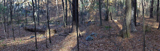 This one illustrates a line ending with a boulder against the far wall:
 Looking across the valley.
  This one illustrates a line ending with a boulder against the far wall:
Tuesday, November 20, 2007
Barstad's Comments About Newport Tower (A Rant)
by JimP
From Larry Harrop's blog comes this item. Janet F. Barstad, president and historian of Chronognostic Research Foundation of Tempe, Ariz., just presented her conclusions to the City Council of Newport, RI following two excavations of the Newport Tower at Touro Park. Click here to read the story.
Barstad makes the following comments:
Barstad apparently missed some history. Surely, one cannot argue that most 17th century colonists built in wood. However, the first leader of the Warwick colony in Rhode Island was a man named John Smith. Not only was Smith a master stone mason, he built what was known as his, "stone castle," in Warwick in the 17th century. The stone castle was demolished in 1795.
So not all of Arnold's contemporaries built in wood. In fact, one of his contemporaries -- a man Arnold surely knew well -- is known to have built in stone.
But you don't even have to go to historical records to find 17th century stone buildings in Southern New England. In Guilford, CT still stands the Henry Whitfield House built c. 1639.

Furthermore, Daniel Gookin specifically praised the Warwick and Narragansett Indians for their hard labors, particularly at erecting stone fences.
So we've got proof of a 17th century master stone mason in Rhode Island, and we've got proof of the 17th century labor needed to build large structures in stone.
We've got absolutely no documentation whatsoever -- not a single letter or diary entry -- out of all the materials that we have -- where anyone at all that visited Newport in the 17th century said anything like, "Golly, what an odd stone tower to find out here among the heathen," at a time when such a thing would've been such an enormous curiosity. People would've come from miles around to see it.
I don't get why we're still talking about 12th century European origins.
From Larry Harrop's blog comes this item. Janet F. Barstad, president and historian of Chronognostic Research Foundation of Tempe, Ariz., just presented her conclusions to the City Council of Newport, RI following two excavations of the Newport Tower at Touro Park. Click here to read the story.
Barstad makes the following comments:
"I'll come right out and say it," Barstad said in a written report to the City Council. "The tower is not 17th century, and it wasn't built by Benedict Arnold. Arnold owned the land on which it stood, and he might have tried to make a windmill out of it. But he and his contemporaries built in wood - their houses, churches, windmills, even their ironworks at Saugus, Rhode Island stone-enders notwithstanding."
Barstad apparently missed some history. Surely, one cannot argue that most 17th century colonists built in wood. However, the first leader of the Warwick colony in Rhode Island was a man named John Smith. Not only was Smith a master stone mason, he built what was known as his, "stone castle," in Warwick in the 17th century. The stone castle was demolished in 1795.
So not all of Arnold's contemporaries built in wood. In fact, one of his contemporaries -- a man Arnold surely knew well -- is known to have built in stone.
But you don't even have to go to historical records to find 17th century stone buildings in Southern New England. In Guilford, CT still stands the Henry Whitfield House built c. 1639.
Furthermore, Daniel Gookin specifically praised the Warwick and Narragansett Indians for their hard labors, particularly at erecting stone fences.
So we've got proof of a 17th century master stone mason in Rhode Island, and we've got proof of the 17th century labor needed to build large structures in stone.
We've got absolutely no documentation whatsoever -- not a single letter or diary entry -- out of all the materials that we have -- where anyone at all that visited Newport in the 17th century said anything like, "Golly, what an odd stone tower to find out here among the heathen," at a time when such a thing would've been such an enormous curiosity. People would've come from miles around to see it.
I don't get why we're still talking about 12th century European origins.
Sunrise on the north side of the hill in Berlin, MA
 I saw this on the left heading out of town on Linden Rd. I caught a glimpse of it as I drove by.
Check out a new blog
Note the new link, in the blogroll to the right, for "Stone of New England". This is a website about stone work, including topics of interest such as quarry marks and curiousities in the woods.
500 Nations
Geophile
I just ran across a series of videos called 500 Nations, narrated at least in part by Kevin Costner but with a host of native people involved. It is about the histories of native peoples of North And South America, with computer models, photos from museums, etc.
I figure that probably many of you have seen it, but since it had gotten by me until now, maybe someone else who reads this would like to know about it, too. The first segment on Google Video is here and there are links to the rest, but you can probably buy it on DVD. I have only seen a little of it, but the research appears to have been extensive. If you've seen the whole thing, let us know if you liked it.
Monday, November 19, 2007
Stone House
A reader writes in from his blog at http://stoneofnewengland.blogspot.com:
I reclaim and salvage stone before it goes to waste. I come across many things in the woods!
Here is one example of a stone I found in Charlton. I bet this caught the attention of any passer-by.


I reclaim and salvage stone before it goes to waste. I come across many things in the woods!
Here is one example of a stone I found in Charlton. I bet this caught the attention of any passer-by.


Sunday, November 18, 2007
More on Waramaug's Grave - from Norman Muller
Norman writes:
Lion Miles, an excellent researcher from Stockbridge, MA, sent me the message below about Waramoug Monument:
I'm positive that the woodcut of the Waramaug Monument does not come from the De Forest book. I own a first edition of it, published in 1851, and there is no such engraving. My copy is complete, containing four wood engravings of landscapes and six so-called "fancy pieces." Both Howes and Sabin list three later editions, in 1852, 1853, and 1871, but they all have the same collation as the 1851 edition. Further evidence that the picture does not come from De Forest is the fact that his text makes no mention of the monument at all.
De Forest wrote that his woodcuts were copied from John Barber's Connecticut Historical Collections (New Haven, 1838). I own a second edition of that from 1846. It has 200 steel and wood engravings, but not the picture of the Waramaug Monument. However, it does talk about it:
"For some time after the white people came here [New Milford], an Indian chief or sachem, named Werauhamaug, had a palace standing near the Great Falls, where he resided. ... He was so considerable a personage as to have reserved, as his hunting ground, a considerable part of the present society of New Preston, which always, until the incorporation of the town of Washington, of which it is a part, was called Raumaug, after the original proprietor, dropping for convenience sake, the prefix we. I have often seen the grave of this chief in the Indian burying ground, at no great distance from his place of residence; distinguished, however, only by its more ample dimensions, from the surrounding graves, out of many of which large trees are now growing.
There is a similar burying ground on the west side of the river, opposite to and in sight of our village, (New Milford) on the bluff, bounding the Indian field, so called, and contiguous to Fort Hill, the site of the last Indian fortress known to have existed in this town."
I have a very extensive library and I may find the source of that print somewhere but, for the moment, the best description of the monument comes from Samuel Orcutt's The Indians of the Housatonic and Naugatuck Valleys (Hartford, 1882), page 111:
"[On Falls Mountain], where it rises gradually towards the northeast, at a distance of about eighty rods from the gorge, is located Waraumaug Monument -- a rude pile of small field-stones, circular in form, of two and a half feet in diameter, cone-shaped, with a single stone standing upright at the top -- all of it nearly six feet in height. Here Waraumaug was buried (of which fact there can scarcely be a doubt, since the Rev. Daniel Boardman, probably, attended his funeral, and at the least knew where he was buried), he having requested, as it is said, to be buried here, that he might look abroad upon the beautiful country of his people, and not feel lonely in the future life to which he was going. Here was he laid to rest about the year 1735, and the monument was then erected, for as it now is, so it was seventy years ago, as testified to by the oldest inhabitants, and 'so it had been,' said their fathers, from the first. It is said that the Indians had a custom that whenever they passed this monument they brought a small stone and threw it down at the base of the pile in honor of the departed chief, and hence, scattered about within three feet of it are a bushel, perhaps, of such stones, indicating by this small amount that not many years after his burial his brethren the Red men ceased to pass that way, having removed to a distance, and that the white brethren have scarcely disturbed a stone of that monumental pile."
I'll keep searching for the woodcut in question. A clue would be the name of the engraver in the lower lefthand corner but it is difficult to read. I also know Trudy Richmond and could simply ask her where it came from.
Update (more from Lion Mile):
This is from the 1938 edition of the W.P.A. Guide to Connecticut, page 453:
"On the summit of Lovers' Leap, Chief Waraumaug was buried. The spot, in the Hurd Estate (not open), was formerly marked by a rough stone monument and the usual pile of stones built by passing warriors as a mark of respect, but the great house was erected, and the main fireplace now stands directly over the chief's grave."
Saturday, November 17, 2007
Along Bower's Brook- Harvard, MA
We are east of the brook in the Ohlin Conservation Land. Bower's brook is in the background. And here is a trench in the side of a hill with a long rock pile, broken into two pieces to the left. It looks like they took away the sand and left the cobbles behind. This is a typical pattern for sand and gravel quarrying. But then, out here in places like Harvard, MA you are never sure even with the most mundane earthmoving.

 And here is a trench in the side of a hill with a long rock pile, broken into two pieces to the left. It looks like they took away the sand and left the cobbles behind. This is a typical pattern for sand and gravel quarrying. But then, out here in places like Harvard, MA you are never sure even with the most mundane earthmoving.
Thursday, November 15, 2007

Wednesday, November 14, 2007
CT Standing Stones In Cairns
by JimP
These are the two images I was telling Norman about. The first is a photo sent to me by Jim Egan of a cairn in the Pachaug State Forest. The second is from a historical source.

These are the two images I was telling Norman about. The first is a photo sent to me by Jim Egan of a cairn in the Pachaug State Forest. The second is from a historical source.


Characteristics of a field-clearing pile
A field clearing pile should be

- Near a field
- Have arbitrary dumps of rocks of different sizes

The view east from a hill in East Princeton, MA
I thought readers might like to see what the view looks like here at this time of year.
Stepping back a few feet from the edge:

Stepping back a few feet from the edge:
A rock pile marking a boundary
At one hilltop I visited last weekend I found an isolated pile with a standing stone. I know for a fact that this hilltop is the corner of a property - on my topo it is a corner of one small piece of Leominster State Forest.
 If I did not know this was a boundary corner, I might have compared this to the piles with standing "manitou" stones we saw last week from Norman Muller. Note the blue tags on the tree behind:
 There was even a hint of quartz in the pile - someone added a couple of pieces.
 Nice even though not ceremonial:

A small Wachusett facing rock pile site
I have written about what I call "marker piles" and, in particular about marker pile sites which face Wachusett [for example here] [especially here] [or more generally here]. The idea that Wachusett is a central location in the Native American spirituality of eastern Massachusetts first was told to me by Curtis Hoffman. At the time I did not think there was that much basis for the idea and, in the end, I do not think Wachusett was by any means the only such important location, or that viewing distant prominent hills is the only reason for building a rock pile site. Up north of here, in places like in Westford, Tyngsboro, and Townsend, there are very similar rock pile sites that face towards the west and northwest - certainly not facing Wachusett. (Perhaps they might be facing Monadnock.) Anyway these sites appear near a hilltop on a slope facing a prominence and the piles are similar in size and tend to be evenly spaced and in lines.

 Occasionally there will be a single (?) pile with a piece of quartz. That one pile will look a lot like a grave but this is a very particular context of a pile with quartz and I do not think these sites are graveyards.
 Last week I noticed a small hill east of Wachusett and, liking to explore out that way (I think it was East Princeton), I headed out on Saturday. I saw some nice woods and eventually got up to the hilltop. There were houses there and I was prepared to be disappointed but I skirted the development hoping there would, at least, be woods to the southwest in the direction facing Wachusett. There was and I was walking along, saw one rock pile hidden in the pine needles and then realized there were numerous low piles - almost completely buried in the duff. At first seeing a white quartz piece in one pile, I thought: "hmmm....graves?". But then I saw the three piles in a row, evenly spaced. This swung my opinion over more towards it being a marker pile site. Here is another occasional feature of a marker pile site: a single rock-on-rock with a curious suggestive shape near at the upper side of the site:
  (For reference, here is one of the nicest of all marker pile sites I know (in Stow MA). Note the single pile with quartz and the single example of a rock-on-rock. [Click here]) You can see this rock-on-rock at the end of line of three items, two rock piles and this rock-on-rock.
  Although you probably cannot make it out through the glare, here is a view of Wachusett, to the southwest. The white tower at the top of Wachusett was visible when I took the picture.
  These piles are more substantial than you would think at first glance. They are very broken down and well covered:
  Finally, here is a bit of a panorama to help give the mood of the place: Taking this picture, Wachusett is off behind my left shoulder.
Subscribe to:
Posts
(
Atom
)