Wednesday, March 31, 2010
"Censored News" - Indian News
[Not rock pile related] Found this by backtracking a reader and thought it might be of interest. http://bsnorrell.blogspot.com/
New Cairn Site - Bolton VT
Norman Muller writes:
 Also, Ernie sent me a photo of a cairn with a hole in the top.
Ernie Clifford, a long-time NEARA member from Vermont, took these pictures at a new cairn site in Bolton, VT, last weekend. Apparently there are a number of split boulders at the site, and one of them has a quartz cobble in the void. Didn't you say that you had not seen a quartz cobble in a split boulder?
If so, here is your first example. [It is actually the third example I have seen - PWAX]
If so, here is your first example. [It is actually the third example I have seen - PWAX]
 Also, Ernie sent me a photo of a cairn with a hole in the top.
Visit to Cheney Audubon Preserve in Montville, CT
From Ted Hendrickson:
We were walking in the Audubon Preserve in Montville recently, right next to the area we visited on Beaverdam Hill last fall. Lots of cairns on boulders and a surprising little valley/hollow with rock constructions aplenty. While some encountered seemed like they could be building piles for the many walls, the valley/hollow area didn't make sense to me as that. It was very wet and boggy. Ledges sloped into it blocking light forming a rocky frame to the scene, not a likely farming or grazing spot to my mind. An inordinate amount of piling and stacking going on.
 Very intriguing collection of structures included this little collection of piles in a central location.
 Lower down, a nice stack on boulder. Hmmm...
 You can see some of the other piles on boulders in the background. Here is a rough panorama of the context.
 My feet were sinking into the bog-like ground as I shot these images. Further up on the right of this image is the path that brings you near this valley. Just on the other side of the path a few more interesting piles with an interesting upright triangular stone.
 There is an colonial foundation further on and many walls which seem to be field boundaries. However , some of the boulder cairns looked like they might be responding to the splits or structure of the supporting stone.
 An interesting site that Norman has visited. I will be going back to look into reports of a larger pile deeper in the property.
Manana Island Cairns - by Mary E. Gage 3/29/10
Introduction 
Manana Island is located ten miles off the coast of south central Maine next to Monhegan Island. Manana is the smaller of the two islands and is located on the west of Monhegan. Manana Island can not be discussed without a brief look at what took place on Monhegan Island. Long before the Europeans first set up a fishing station in the 1600’s on the island local Native Americans had done likewise.

Fig. 1 - USGS Map of Manana and Monhegan Islands
Monhegan Island
I walked over this island from end to end but did not have time to walk every trail. No cairns were found on it. The museum which I also missed visiting has a collection of Native American artifacts on display that were collected on the island. A letter from the island’s historical society stated that Arthur Speiss the Maine State Archaeologist had seen the collection and gave them a brief synopsis.
1. Bifircate Base Point – Early Archaic 8,000 years ago
2. Felsite Point – Moorhead Phase (Archaic)
3. Barbed Bone Spear, a Bone Awl, a Ground Beaver Incisor, many Sinkers, Abrasive Stones, Slate Spear Point fragments, Gouges, Axes, Scrappers, Choppers, Shaft Abraders, Hammerstones, Grindstones, and a Susquehannah Broad Point – Late to Transitional Archaic 3,400 years ago
4. Side Felsite Point – Ceramic Period 1,000 to 1,200 years ago
“From all recorded accounts, archaeologists believe the island was used as a seasonal base during the late summer and autumn months while the codfish and swordfish were abundant, about 3,000 to 4,000 years ago.” This statement was from Tracie Bracy, curator of the Monhegan Historical & Cultural Museum (Letter: Sept. 25, 2002). It reflects the bulk of the Native American artifacts that date to the Late to Transitional Archaic Period. It does not take into account the Early Archaic and Middle Ceramic period which are poorly represented but none the less represented showing the Native Americans went out to the island before and after the main fishing period.
In the book Monhegan The Cradle of New England by Ida Sedgwick Proper (1930) she stated “that there were numerous Indians quartered [camped] on the Island [Monhegan] is recorded by Gorges in his Briefe Relation, among whom was undoubtedly Samoset.” (page 136). Gorges was in the area in the early 1600’s. In turn, this places Native Americans on Monhegan in the Late Ceramic / Proto-Historic Period.
Native Americans went out to Monhegan Island. Manana Island is a short row boat ride across the harbor from Monhegan Island.
Manana Island
In September of 2002 I made a visit to Manana Island to see the petroglyph [click here for related article] which I wrote an article on that was published in the Maine Archaeological Bulletin Vol. 44, Spring 2004 (see website for copy of article). While there I found the island was covered with cairns.
The island is ¾’s of a mile long by ½ mile wide. Its length is oriented approximately north – south and width east – west. The island is a rounded knoll with a raised outcrop on the west side and a slightly raised north end. On the west side (open ocean side) there is a natural wide gulley paralleling the north end. On a flat short ledge above the gulley is the petroglyph. The island is covered with long grass and short brushes around the edges. A spring located in the middle of the west side was stone lined and shaped into a rectangular pool.
The island has several buildings. One is an abandoned 1960’s house on the east side. On the west side the Coast Guard built several buildings. The house, a storage shed, and fog horn building are still standing. In addition there is the long boat rail/launch on the east side which has been turned into a raised wooden walkway for visitors. In the gulley area near the Coast Guard buildings there are several piles of stone with rubbish mostly an assortment rusted metal parts presumably from the Coast Guard era. Some of these stone piles are on exposed bedrock surfaces and may be cairns.
Two Cairn Fields
Geographically there is the short raised north end, and the long undulating middle section / south end. On the north end there is a small quantity of small cairns. Cairn designs found here are On Top of Stone and Split Stone. The On Top of Stone cairns each have a few stones that do not cover the whole base stone. Plus, not all the exposed bedrock surfaces and boulders have cairns. The petroglyph is on a ledge face on the north end. It faces south and is beside the gulley which is angled southwest out to the open ocean. Anyone visiting the island may want to take a compass reading along the face of the petroglyph to access a possible sunset alignment.
The middle section / southeastern end form the second section. The section is denoted by the cairn with the large triangular slab leaning against it. The cairn is on the south side of the boat rail/launch. To the north of the cairn on the other side of the boat launch note there are a few exposed areas of bedrock among the grass that do not have cairns. This forms a dividing line between the two areas. Starting at the cairn with the triangular stone all exposed bedrock which look like in-ground boulders level with the ground’s surface contain a cairn for as far as you can see. I estimated between 50 and 75 cairns but did not have time to make a count. This pattern continues until you reach the southwestern corner of the island. There the cairns are scattered among numerous exposed bedrock surfaces without cairns. Cairn designs in the middle section / southeastern end On Top of Stone, One Stone on Top, Split Stone and Leaning Against Boulder. The striking characteristic of the On Top of Stone cairns in this section is each cairn completely covers the base stone it is on. The cairns range from large (10’L) to medium (7’- 4’L) to small (2’-3’). Short rows of boulders abutting each other 7’L x 2’W on the ground may be features. On the east side of the island near the water’s edge (field notes) and near the 1960’s house (? memory) there is a wire fence enclosed circular feature and an enclosure. The circular feature looked like the top of a well shaft but it only had a single layer of stone which made it unsuitable for a well. Above ground it was 2’H x 1’W x 3’Dia. (interior) and was ½ filled with stones. Ten feet away was a U shaped enclosure. The enclosure opened to 320 degrees NW. It had a few scattered stones inside. Size: Interior 3’L x 2’W. A couple of cairns were located below these structures at the waters edge.
 Fig. 2 - Sketch Map of Manana Island showing location of cairns and other structures
Occupants on Manana Island
1. The Coast Guard built a fog signal station on the island in 1855 which was staffed until the 1980’s.
2. Ray Eugene Phillips lived as a hermit on Manana from 1930 to 1975 and maintained a flock of sheep there.
3. In the 1960’s a hippy and his family built the house on the east side and lived on the island for a couple of years.
Analysis of the Cairns
The cairns are divided into two distinctly different types of cairn fields. The north cairn field has a small quantity of small cairns and the petroglyph. The middle/south cairn field has a large quantity of large cairns, a cairn with a triangular standing stone, a spring, an enclosure and a circular structure. The basic differences in the cairn fields preclude that any of the Euro-American occupants built the cairns. If an island resident like Mr. Phillips who maintained sheep on the island had built the cairns he would not have made the distinction between the small scattered cairns on the north end and the large cairns on every exposed bedrock surface on the middle/southeast section. Furthermore, the petroglyph which has been identified as Native American and the enclosure must be taken into consideration. The integrating of the petroglyph and enclosure into their respective cairn fields along with the differences in the On Top of Stone cairns, the triangular stone leaning against the cairn and the additional cairn designs indicates the cairns were built by Native Americans for ceremonial purposes. The small cairn field on the north end can be interpreted as a shaman area where one or two people went for a specialized ceremony. The large cairn field on the middle section / south end can be interpreted as a community area where a group of people gathered for the main ceremony.
Fig. 3 On top of boulder cairn with triangle standing stone

Fig. 4 - Column like cairn

Fig. 5 - Overall view showing the middle / south cairn field

Fig. 6 Elongated cairn on stone

Fig. 7 - Small stone cairn

Fig. 8 - More elongated cairns
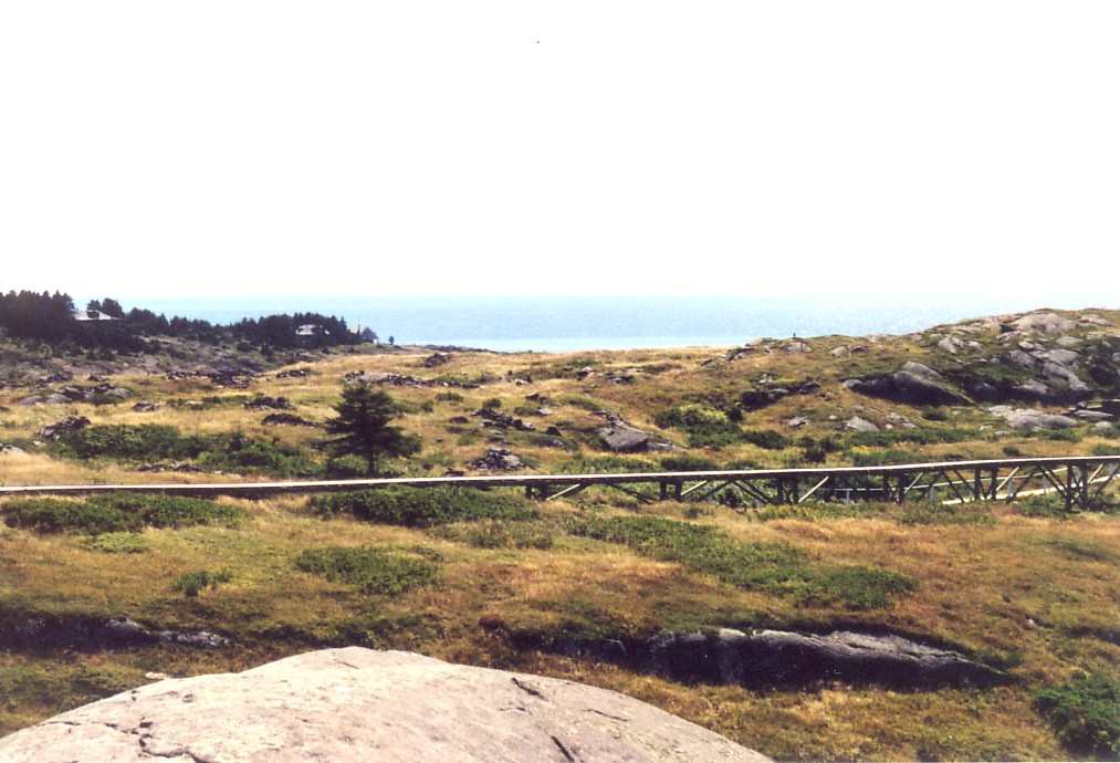
Fig. 9 - View of north cairn field
Tuesday, March 30, 2010
Spring Street access to Upton State Forest- Rock Piles with Quartz
[Continuing from here] I went back down the hill and passed through the site I saw first, then realized there was another section of that site down hill. Although this is really part of the same site, it felt slightly displaced from that and since most of these piles had fine chunks of quartz in them, it continues to feel like a slightly different site. Here, without more ado, are rock piles in lines, more or less evenly space, and with dominant quartz features.
Start at the top, with this split rock arrangement: Adjacent to that a quartz pile in the foreground and another in the background:
 Closeup of the foreground pile:
 I believe this is a type of "marker pile" site but am not used to seeing so much quartz on display. Usually if it occurs in a line of rock piles it is on one pile at the end of a line of piles. Here we get some sense of the layout, lower down on the hill:
 Let me call attention to the pile the right with a huge quartz chunk, and on the far left a little 'table' like arrangement. Here is that chunk of quartz pile, looking back the way we came downhill:
 And here is that 'table' in context:
 And closeup:
 It certainly looks like a place that an offering might be made and adds to the sense that this is a place of ceremony.
Finally, here we are at the bottom of the split rock we started with. These rock piles, although small, were very powerful.
Start at the top, with this split rock arrangement:
 Adjacent to that a quartz pile in the foreground and another in the background:
 Closeup of the foreground pile:
 I believe this is a type of "marker pile" site but am not used to seeing so much quartz on display. Usually if it occurs in a line of rock piles it is on one pile at the end of a line of piles. Here we get some sense of the layout, lower down on the hill:
 Let me call attention to the pile the right with a huge quartz chunk, and on the far left a little 'table' like arrangement. Here is that chunk of quartz pile, looking back the way we came downhill:
 And here is that 'table' in context:
 And closeup:
 It certainly looks like a place that an offering might be made and adds to the sense that this is a place of ceremony.
Finally, here we are at the bottom of the split rock we started with. These rock piles, although small, were very powerful.

Upton State Forest from Spring Str (part 2)
[Continuing from here] On the level part at the top of the hill were a few other rock piles and a bit of a structure. Here is one pile: Here is something with a bit of quartz in it:
 Closer:
 Here you see a foundation or a well or some kind of man-made hole in the ground:
 Closer:
 You also see many hints of structure up there.
 Like the indeterminate forms lower on the hill, I did not study these carefully. Someone could spend a long time mapping and studying this place.
As a last example, here was an anomaly in the stone wall.
 I considered whether it might have gotten levered up by chance but, no, it was very firmly planted.
We know the Nipmuck families lived and still live in Upton and Grafton. And this was near or in the Praying Indian Village of Hassenemesitt. It matches the neighborhoods of other known Praying Indian Villages - woods full of rock piles. That this is a Nipmuck neighborhood only increases my expectations.
 Here is something with a bit of quartz in it:
 Closer:
 Here you see a foundation or a well or some kind of man-made hole in the ground:
 Closer:
 You also see many hints of structure up there.
 Like the indeterminate forms lower on the hill, I did not study these carefully. Someone could spend a long time mapping and studying this place.
As a last example, here was an anomaly in the stone wall.
 I considered whether it might have gotten levered up by chance but, no, it was very firmly planted.
We know the Nipmuck families lived and still live in Upton and Grafton. And this was near or in the Praying Indian Village of Hassenemesitt. It matches the neighborhoods of other known Praying Indian Villages - woods full of rock piles. That this is a Nipmuck neighborhood only increases my expectations.
Spring Street access to Upton State Forest (part 1)
 Upton MA is a town that "never disappoint". Rock piles are all over the place in the woods. So I was hopeful, driving south on Spring Street looking for access to the state park. As soon as the houses drop away and the blue "State Forest Boundary" labels start appearing on the trees, there is a bit of a wetland. I parked just south of that and started diagonally up the hill. Within a few paces there were a couple of very broken down rock piles covered with leaves.
Continuing, you cross a brook [I stepped deliberately on the quartz as it seemed appropriate]:
 And a few other obscure things that do not photo well - loose collections of rocks that spell something to the informed (not me). Continuing uphill, you soon get to a place of beautiful stone walls:
 Let's have a look at some of these piles:
 I got the feeling they were evenly spaced but did not pay close attention.
 I was interested in that larger structure in the background, which turned out to be a gateway or large split boulder with rock piles on it:
 This one caught my eye as part of Tim MacSweeney's "Turtle Vision" thing. But rather than seeing this as a turtle, highly symmetric as it is, it is worth looking at as being a representation of something else.
 With due respect, it is not always about turtles. In any case, that does look like some kind of effigy.
Rocks in the sunlight:
 And a few other notables, as I continued up hill, where there was another site.
 As I said: non-stop rock piles in those woods.
Some Flanders Photo's
Or somewhere where I used to think was lots of colonial construction...
 http://wakinguponturtleisland.blogspot.com/2010/03/flanders-nature-center.html

Monday, March 29, 2010
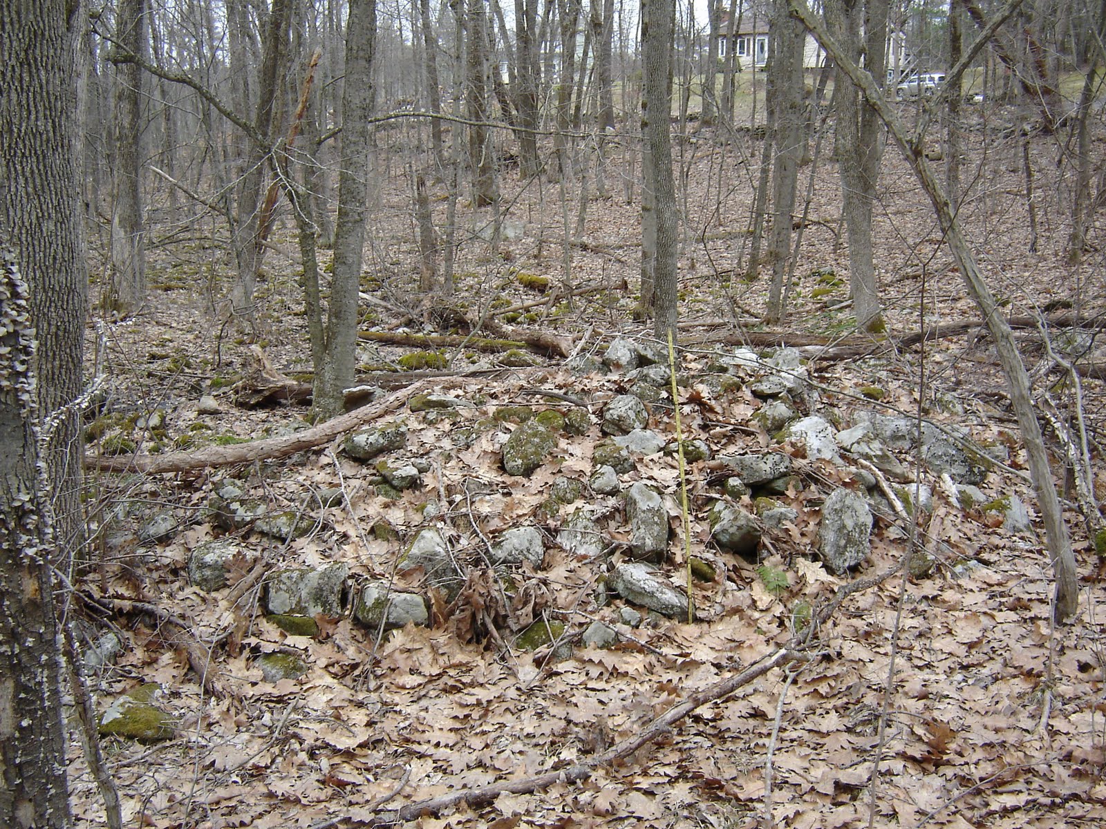
Large Rectangular Rock Pile with Hollow - Spencer State Forest
Mike H from Sturbridge writes:
I found a 26' x 26' x 5 foot high pile next to a small stream in the Spencer State Forest, across from 5 Hebert Road in Spencer,MA. The pile is hollowed out in the middle on the eastern side.
The First Photo is taken from the Road side The next three photos are taken as I went around the pile is a counter clockwise direction.


I found a 26' x 26' x 5 foot high pile next to a small stream in the Spencer State Forest, across from 5 Hebert Road in Spencer,MA. The pile is hollowed out in the middle on the eastern side.
The First Photo is taken from the Road side
 The next three photos are taken as I went around the pile is a counter clockwise direction.

Gary SD mounds and rock piles
[From here] "Indian Mound
About three and a half miles to the south of Gary, South Dakota, located at Cobb Creek, there is an Indian Mound. In 2008 it was inspected by a Tribal Chief and a Director of the Upper Sioux Agency. It was determined that it is a perfect example of a “Mound with a Tail” because of the way it is built. When you come to this area, make sure you get a chance to see this rare Native American attraction." [emphasis added]
(adding) gotta go look that up on Google.
Update: appears to refer to things like this:

Protecting rock piles in Westford - MA
Frank from Westford writes:
Yesterday, I learned that a developer gave the land, to the south of me, to the town. Tomorrow, the town will vote to put it into conservation. I walked over the land, and found some very interesting rock piles.
All of my life, I have seen rock piles from stone walls and quarries. But, these piles are unlike anything that I have seen before, except on your web site. I believe that I have found nine piles forming three lines. It appears that they are at right angles, with two lines pointing north-south and the other east-west. You can see this from the shadows. The piles appear to be evenly spaced. ...
...If I can show that these rock piles have archeological or historical value, the Conservation Commission will try to protect them, just as they have tried to protect other historical sites in Westford. Otherwise, they will probably be damaged or destroyed.
The pictures are posted at: http://home.comcast.net/~j1rzk/rock_piles.htm
The home page of my site is at: http://home.comcast.net/~j1rzk/
Comment from PWAX: It sounds like what I have been calling a "marker pile" site and, yes, it is worth preserving - especially as these are not so common in the Westford area.
"Revere Rock"
BerkMtnMan sends this:
Labeled as "Revere Rock" the location is given as Lexington. Date is circa 1890's and is from a glass slide. Does anyone recognize this?
Labeled as "Revere Rock" the location is given as Lexington. Date is circa 1890's and is from a glass slide.
 Does anyone recognize this?
Sunday, March 28, 2010

Subscribe to:
Posts
(
Atom
)