
Saturday, June 29, 2013
Princeton Rd Westminster- old friends
Going south from near Hager Park, on Princeton Rd. I was reminded there are several "roadside attractions:" along there. Just north of Wachusett, the woods really are full of things:

Hager Park Westminster
Just south of Rt 2, on the way to Mt Wachusett, there is a small hill and a sign for Hager Park.
 I went in from the southwest on a forest rd, then cut diagonally uphill. I saw one minor item then continued uphill (I should have looked around more carefully):
 There were a few traces at the top of the hill but I soon went back down the east side. Saw a young porcupine, then some traces of wedged rock. At this point - part way down the slope, I started looking a bit more hopefully.
I saw a little bump in the ferns, discovered it was a rock pile and decided to groom it -removing some of the plants growing on it. Here it is before cleaning:
 and after:
 You began to see that it was quite big,~15 feet across, with a faint "dimple" on the uphill side. In one place along the lower edge I cleaned a little more of the dirt, down to the rocks. And I could see they went at least another foot deeper. Old.
So after that I started exploring that southeastern slope more carefully. There were other mounds scattered around, very hard to see:
 This was hard to make out. More or less completely settled, a few glints of quartz, an indistinct outline. It seemed to taper off into a linear element- a "tail", a "berm", a bit of wall. There were other impressions of linear elements combined with old mound. You get a little bit of the shape:
 But no wonder people do not realize how the state's woodlands are packed with Indian burial grounds. They are invisible! It has taken fifteen years for me to learn to see this stuff.
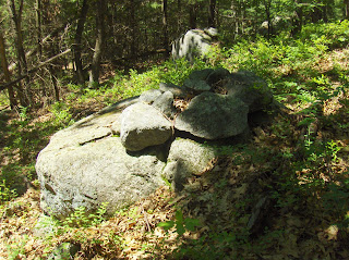
The "piece de resistance" was a larger rectangular mound with a hollow, in a familiar design but here the whole structure was raised up on top of a larger platform:
 The rocks in the foreground are part of what I am calling a "platform". Another view:
 Another view, of the hollow:
 This mound was in the laurels in the flatter area, at the eastern foot of the hill.
So things are little different out here - way out west. Mt Wachusett looms over this little hill and there would have been an excellent view of the mountain, if not for the trees. Here, as further east and north, there are rectangular mounds with hollows. But these were quite old, perhaps shaped a bit differently, and mostly invisible under the forest growth.

I saw a little bump in the ferns, discovered it was a rock pile and decided to groom it -removing some of the plants growing on it. Here it is before cleaning:


So after that I started exploring that southeastern slope more carefully. There were other mounds scattered around, very hard to see:


The "piece de resistance" was a larger rectangular mound with a hollow, in a familiar design but here the whole structure was raised up on top of a larger platform:


So things are little different out here - way out west. Mt Wachusett looms over this little hill and there would have been an excellent view of the mountain, if not for the trees. Here, as further east and north, there are rectangular mounds with hollows. But these were quite old, perhaps shaped a bit differently, and mostly invisible under the forest growth.
Friday, June 28, 2013
The key to northeast Fitchburg
Where Baker Brook, Pearl Hill Brook, and Mulpus Brook form wooded valleys:
 The main "key" is the conservation land parking on Rt 113 with access over to Pearl Hill Brook to the west; or north up beside Stagecoach Rd all the way to Mulpus Brook. But there is also parking at Coolidge Park (a baseball field) to access the lower valley of Baker Brook.
It is strange that I looked at the map for years without seeing these possibilities. Now I have enough for a few weekends and....it's Fitchburg!!!!

It is strange that I looked at the map for years without seeing these possibilities. Now I have enough for a few weekends and....it's Fitchburg!!!!
Wednesday, June 26, 2013
Something going on here
Starting back down the hill at Hager Park, Westminster, saw this curved line of rocks. I did not even suspect I was about to step into a site.


Later I found several large, buried "mounds" that included low linear extensions and shapes impossible to make out in the ferns. Here is a video of one hard-to-see earthwork. It was a structure a bit like this:
The video:
Monday, June 24, 2013

Saturday, June 22, 2013
A lucky week- Part 2
In the days after all my finds on June 9 I found a few hours after work to go and hit some favorite spots. I walked quite a bit in one place where I have found a lot of stuff before, hoping that the rains might have exposed something new, but there just wasn't a lot of exposure and I came up with nothing. On the way home I stopped at another place for only about 15 minutes. I got excited when I saw this:
 Unfortunately it is not as nice as I hoped it would be, it is a small stemmed point made of argillite, broken, and rather crudely made.
 I also found another argillite artifact in that same spot, but even more crude, maybe a really rough knife or scraper, or a preform.
 The next day I spent a lot of time in that same spot and found only two strange quartz artifacts that I can't readily identify. One is like a Squibnocket Triangle with a stem coming out of one corner(?). The other is maybe a broken drill.

 Saturday, June 15, I returned to the spot where I had had so much luck the previous Sunday. As I wrote, I didn't have a lot of time there the first time and so I just blasted through looking for obvious stuff. I hoped that if I checked the whole place again, more carefully, I would have more luck. And I did. It had rained quite a bit since my previous visit, too, and new stuff was exposed. This small stemmed point (Wading River) is missing its tip but it looked great on the ground, with the stem sticking out.

 I was specifically focusing on looking for materials other than quartz. But in this place, I kept finding broken quartz arrowheads. I read a survey of collections from eastern Massachusetts prepared by an archaeologist that indicated that while collections from north of the Mass Pike consisted of about 50 percent quartz arrowheads, collections from the southeastern part of the state were dominated by quartz.


 I finally did find something that was not quartz. This argillite piece really got my heart pumping! Unfortunately it is just a broken part of a blade, I was really disappointed.

 Here is a strange one. It's whole, I'm not sure what to call it really. Maybe a specialized tool, a perforator or a drill of some kind?

 I found these two small stemmed points within a few feet of each other.

 Here are a few photos of some of the better finds from both trips to this small area, once I had got them home and cleaned off most of the dirt. I think this has to be the most productive area I have ever searched, based on sheer quantity.


Percolating
While some sort of post about stone walls/stone rows is percolating, I started a little search for "Abandoned Stone Walls," as Prof. Thorson likes to call them - and define them. I contend that there's artistic imagery in the Native American "stone concentrations," as Prof. Thorson likes to call and define them, a way to stack the stones that recall animals important to the inhabitants of Turtle Island, some human like figures in there too. If the stones are placed to resemble/recall a bear or a deer or something, it may possibly be intended to remind you of a bear or a deer or something.
I have stared at some stones in some mounds I've slowly been clearing debris off of, for at least 6 or 7 years now, up by my old chicken coop. It took a long time to realize there were many "single stone turtles" in among the other stones, even longer before I realized that what I thought was debitage might actually be the representation of the shell fragments surrounding a baby turtle.
(See: http://wakinguponturtleisland.blogspot.com/2013/02/just-past-pipping.html )
Like they say, "How long will you walk this trail of wisdom? Well, you will go to many places. You must look at them closely. You must remember all of them. Your relatives (and your friends hopefully) will talk to you about them. You must remember everything they tell you. You must think about it, and keep on thinking about it, and keep on thinking about it. You must do this because no one will help you but yourself. If you do this, your mind will become smooth. It will become steady and resilient. You will stay away from trouble. You will walk a long way and live a long time.
Wisdom sits in places. It’s like water that never dries up. You need to drink water to stay alive, don’t you? Well, you also need to drink from places. You must remember everything about them. You must learn their names. You must remember what happened at them long ago. You must think about it and keep on thinking about it. Then your mind will become smoother and smoother. Then you will see danger before it happens. You will walk a long way and live along time. You will be wise. People will respect you (Basso 1996:127).”
So in a Google Image search today with "Abandoned Stone Walls" in the box, I stumbled on this one pretty quickly. My first impression: "Single Stone Turtle!"
(All I can capture is this tiny thumbnail image below; check it out on flickr, along with some other photos of some more stones:)
It is a JMurphyDesigns Photo stolen from:
We were talking about this sort of thing a while back, both in NE and the SE:
Wednesday, June 19, 2013
I didn't mean to go to Gardner
More a comedy of errors than a righteous site find. I made several tactical blunders in planning; the worst being that I misjudged the exit off Rt 2 by about 5 miles. So I passed where I thought I should exit then, confused, reversed directions and went back to the first place. Took a walk there in a woods at the end of a road that was similar enough to my plan that I only realized later it was a different place. Back in the car, I finally saw the mistake on the map (compounded by a page break at this spot in the map book) and proceeded to the originally planned exit, then drove far past the turn I wanted and gave up, going into yet another conservation land that looked a bit like the one I planned to visit. In the end I visited two places like the one I planned but never got there (Beech Hill in Westminster).
 At one point on this second walk, I saw a woodcock fly out of the woods and land on the road 20 yards ahead. It spotted me reaching for my camera and took off. On the walk, I just kept going uphill, up and over, trying to get to the back side of the hill (of course this was the wrong hill), and followed a bit of a gully - way high on the hill. There was not much there except walls. One thin trace of a wall led diagonally over to the brook so I followed it - the way you do.

 This is deep in the woods and not an open field above. Instead the thick wall stopped after a few feet, then there as another wall "corner" without much accompanying extension. It was completely covered with ferns. I walked back along the side of the slope and encountered more brief stretches of wall covered in ferns. It was hard going so I stepped down, back into the lower wetlands and hit rock piles - three or more of them.


 Back at my car again I realized this was still the wrong hill. I have it to do.


It led to the brook and across the brook was a massive bit of terracing:


Not much to see. But these terraces mixed with rock piles and a watershed high point are different than what I am used to. I imagine that the further from home I get, the more different things will be. It is only a bit true. I tried to sketch the features in black:

Tuesday, June 18, 2013
More pix from Duck Pond Ridge in Groton
I did not put these in the previous post, but it seems a shame to discard nice pictures.
 This is not the kind of thing you see too often in Groton:
 I guess this is a "marker pile" site.

 Lovely.
 Is this next an effigy?
 The scene:
 Here the walls open to the rock pile site. Obviously designed into the original wall.


Maybe 39-40 rock piles.
Subscribe to:
Posts
(
Atom
)