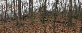
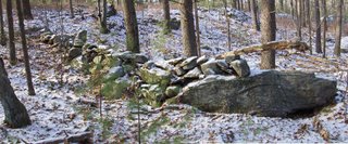
 Note the bumps along the edge of the slope beyond.
Sunday, December 31, 2006
Friday, December 29, 2006
A large U-shaped structure from Snake Hill, Ayer
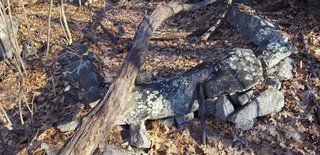 I published a picture of this U-shaped structure in a gully on Snake Hill years ago on the NEARA web page. Back then I thought all "U"s were equivalent. But today I see no similarity between this and the kind of small U-shaped structure which I have come to think of as being a "seat" where someone could sit and watch. Wait, here is what I mean, this picture is from the same general area of Ayer:
 That is big enough for one person to sit.
 But the larger structure above is probably not a seat at all. Could it be the remains of a dwelling?
Aperture Pile
More From Larry Harrop
by JimP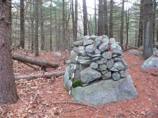 Larry Harrop has another new gallery from Exeter, RI. This time he visited the area of the, "Queen's Cairns," first reported on this blog by me here. Larry has taken many photos and captured several wonderful cairns. [Click here] to see this latest gallery.
[Click here] for all of Larry's terrific galleries.
 Larry Harrop has another new gallery from Exeter, RI. This time he visited the area of the, "Queen's Cairns," first reported on this blog by me here. Larry has taken many photos and captured several wonderful cairns. [Click here] to see this latest gallery.
[Click here] for all of Larry's terrific galleries.
Thursday, December 28, 2006
Guide To Whipple Hill
By JimP
On Peter's request, I have put together this little guide to the structures I found at the Whipple Hill Conservation Area. All labels are approximate. Click on the image for a higher resolution of the satellite photo.

A. Skyline Dr. is where I parked my car.
B. Area of the pyramid stones around two boulders.
C. Enormous stone heaps.
D. Earthen dam with large rocks.
E. Clearing with edge heap. (note: this clearing might technically be part of the adjoining Locke Farm Conservation Area)
F. Three more stone heaps behind homes.
On Peter's request, I have put together this little guide to the structures I found at the Whipple Hill Conservation Area. All labels are approximate. Click on the image for a higher resolution of the satellite photo.
A. Skyline Dr. is where I parked my car.
B. Area of the pyramid stones around two boulders.
C. Enormous stone heaps.
D. Earthen dam with large rocks.
E. Clearing with edge heap. (note: this clearing might technically be part of the adjoining Locke Farm Conservation Area)
F. Three more stone heaps behind homes.
Pair of elongated rock piles
The largest site I know of near here was found by Bruce McAleer in Harvard, MA. Whenever I explore woods adjactent to this major site I discover new clusters of rock piles. Yesterday I went out to explore one fringe area like this and I kept finding things as I explored until I got back to parts of the site I had already visited. So anyway here is an interesting feature I had not seen before:
 Two elongated rock piles, lying side by side. Here is a view from one end:
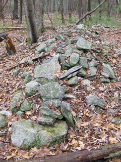 Look closely and you see a little white spot on the right hand side, a a few feet back from the end of the pile. Here is a detail:
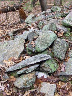 If we look at the far end of the other pile we see something similar:
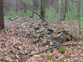
Again there is a white spot. Here is detail: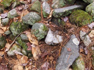 Very symmetric.
 Two elongated rock piles, lying side by side. Here is a view from one end:
 Look closely and you see a little white spot on the right hand side, a a few feet back from the end of the pile. Here is a detail:
 If we look at the far end of the other pile we see something similar:
Again there is a white spot. Here is detail:
 Very symmetric.
Whipple Hill - Part Three
by JimP
see Part One and Part Two
After leaving the pond, I figured I had seen all there was to see. Boy, was I ever wrong! Eventually, a trail brought me to a pleasant little clearing: I had a look around the clearing and came to an area along the edge where there was a very impressive and long heap of stones at the top of the steep drop-off:
 The most curious aspect of this long pile was that it was so organized -- very few of the stones trailed off down the drop-off. Here's another view:
 I left the clearing and continued on the trail back into the woods where I came to an area that was directly behind a neighborhood of modern houses. To my surprise, I came to yet another large heap of stones:
 And if that wasn't enough, I came to another heap:
 And then another still:
 As daylight began to dwindle, I had to cut my exploration short. There was much more of this property that I never saw -- but what I did see was extremely impressive. Thanks to Peter Waksman for directing me there!
In the end, I left this site very confused. These heaps are like nothing I had ever seen before. They were striking in their size and frequency. It seemed to me to be a place of contradictions -- small ground piles and boulder cairns, huge heaps of an incredible magnitude, an obvious earthen dam with more modern stone use, a long pile at the edge of a field -- even more than two months later I'm still processing everything that I saw at Whipple Hill.
see Part One and Part Two
After leaving the pond, I figured I had seen all there was to see. Boy, was I ever wrong! Eventually, a trail brought me to a pleasant little clearing:
In the end, I left this site very confused. These heaps are like nothing I had ever seen before. They were striking in their size and frequency. It seemed to me to be a place of contradictions -- small ground piles and boulder cairns, huge heaps of an incredible magnitude, an obvious earthen dam with more modern stone use, a long pile at the edge of a field -- even more than two months later I'm still processing everything that I saw at Whipple Hill.
Whipple Hill - Part Two
by JimP
See Part One
After a short walk from the pyramid rocks and small cairns, I came to a lovely little pond: After walking near the pond for a bit I could see through the trees an imposing presence -- a gigantic stone heap:
 My photographs simply don't do it justice. It was truly huge and impressive. Here's a closer look:
 From this heap there was a small valley and then another large heap -- only this one was constructed to incorporate a prominent outcrop. The outcrop sure looked like it had a face to me -- it was the first thing that struck me.
 Here are two more photos from other angles showing how the rocks are piled onto the outcrop:
 Then I spotted what looked very much like a man-made niche constructed at the base:
 Near this second heap was another small valley, and then a high hill. I got the impression that the two large heaps were constructed almost to mimick the high hill -- as if to create three separate hills of almost equal size, as though it somehow balanced out the landscape.
After leaving this area I then came to what appeared to be an earthen dam, the pond side of which was built up with large stones. So the pond must be man-made and it was probably, at one time, more of a swamp. I must learn more about the history of this land.
But I was hardly done with this property -- there was indeed more to come. Look for that in the third and final part of my visit to Whipple Hill.
See Part One
After a short walk from the pyramid rocks and small cairns, I came to a lovely little pond:
After leaving this area I then came to what appeared to be an earthen dam, the pond side of which was built up with large stones.
But I was hardly done with this property -- there was indeed more to come. Look for that in the third and final part of my visit to Whipple Hill.
Whipple Hill - Part One
by JimP
During my October trip to Massachusetts and Rhode Island, Peter Waksman recommended a visit to Whipple Hill in Lexington, MA. He kindly supplied me with a rough map, and I was off with my camera to explore.
The first things I saw when I got there were the following two boulders: Nothing seemed out of the ordinary with these two boulders until I realized that surrounding them was a circle of 8 or 9 stones -- all of them rather equidistant from one another, and all of them almost pyramid in shape.


 Some of these stones had such different coloration and properties from one another that it was hard not to conclude that they were somehow placed there intentionally.
Not far from the above formation were a number of small piles -- including this boulder cairn: and also this remnant of a short wall:
 But the best was yet to come -- and I'll get to that in part two.
During my October trip to Massachusetts and Rhode Island, Peter Waksman recommended a visit to Whipple Hill in Lexington, MA. He kindly supplied me with a rough map, and I was off with my camera to explore.
The first things I saw when I got there were the following two boulders:
Not far from the above formation were a number of small piles -- including this boulder cairn:
Wednesday, December 27, 2006
New Larry Harrop Album
Larry writes in:
I made a new album from a conservation area in Exeter, Rhode Island . Lots of split and wedged boulders. I haven't explored all of this site yet. There probably is more.
This site is very near http://rockpiles.blogspot.com/2006/05/queens-cairns.html .
The album is at http://larryharrop.com/main.php?g2_itemId=3108
Tuesday, December 26, 2006
North Monoosnoc - the true summit
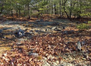
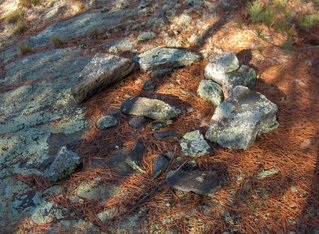
I got to the true summit of North Monoosnoc (Leominster State Forest) today. I guess perviously I thought I got to this summit but I was actually on a false summit to the south. I have to say that North Monoosnoc is probably the prettiest of the hilltops I have seen - with spots of bald rock, moss, and grass, mixed in with stunted scrub oak. Nice muted colors at this time of year. There were some structures I would assume were remnants of ceremony:
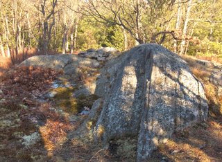
 Right near the highest summit was a little outcrop with a rock pile on it:
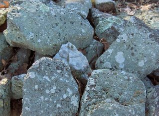
 Here is a detail of the pile, showing a piece of quartz:
 A really beautiful spot and I was happy enough to find this one nice pile.

 Right near the highest summit was a little outcrop with a rock pile on it:
 Here is a detail of the pile, showing a piece of quartz:
 A really beautiful spot and I was happy enough to find this one nice pile.
Monday, December 25, 2006
A Gruesome Tomb Robbery From History
by JimP
I came across this item while perusing Records and Files of the Quarterly Courts of Essex County: Volume III - 1662-1667. The item is from the Ipswich Quarterly Court, March 1667 - pg. 440.
Yes, folks, this is historical proof that cairns were built over Indian graves in Massachusetts during the 17th century.
I came across this item while perusing Records and Files of the Quarterly Courts of Essex County: Volume III - 1662-1667. The item is from the Ipswich Quarterly Court, March 1667 - pg. 440.
Robert Crose, jr., for his barbarous and inhuman act of digging up the grave of the Sagamore of Agawam and carrying his skull upon a pole, was sentenced to be imprisoned until the next lecture day, and immediately after meeting to sit in the stocks for one hour, thence to be conveyed to prison, there to remain until he pay a fine of 6li. 13s. 4d., and he was also bound to good behavior. It was further ordered that within ten days after, he should bury the skull and bones that can be found or brought to him in the place where it was dug up, and erect a cover of stones upon it two foot high or otherwise to pay a fine of 20 nobles more. John Andrews jr., was to assist him when called to it by him under the same penalty.This item, gruesome as it is, is one of the very few pieces of historical evidence we have that gives us clues about how Indian graves, particularly the tomb of a sagamore, would be constructed. It is very unlikely that the erection of a two-foot-high cairn over the grave would be a European idea. It is far more likely that the court was ordering the restoration of the tomb to its original condition, or at least their best idea of how the tomb should be reconstructed.
John Andrews jr., having upon examination freely acknowleged the offences charged upon him, was admonished and ordered to make public acknowledgment next lecture day in public in the meeting house, or pay a fine of twenty nobles. He was also to assist Robert Crose in making up the Sagamore's tomb.
Yes, folks, this is historical proof that cairns were built over Indian graves in Massachusetts during the 17th century.
Rock piles and suburbia
One of my favorite narratives has always been the contrast of ancient sacred sites hiding in the backyards and woods lots of modern suburbia. I always like the theme but thought of it as a bit superficial. After all this juxtaposition of the ancient with the modern may be interesting story telling but it has little to do with the main subject of rock piles. However, once and a while, I am reminded that this story of juxtaposition isn't just narrative fluff but perhaps is itself a crucial part of the story. The more I see it, the more I find it hard to believe, the more the idea is enforced that many of the rock piles come after the European features. It is the only thing that makes sense. So here is a picture which is holographic of the story - containing the whole story within itself: 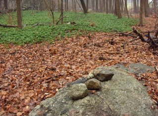 In the background is a large patch of Pachysandra - a popular ground cover used by Europeans as a planting around the house. In this picture it is a very safe assumption that there was a colonial -or later- house with a Pachysandra planting around it and, long since, the Pachysandra has grown and spread out to form this patch we see today. On the other hand, in the foreground, is a rock pile which looks delicate and new. Could the pile be older than the Pachysandra? No way. In fact this part of the woods (eastern foot of Robbins Hill in Chelmsford) looks to be where the reported lime quarrying must have taken place - it is a part of the hill that has been much disturbed. Such a delicate pile would not have survived the coming and going of many people. But there it is.
Why is it so hard to believe this pile is recent and the Pachysandra is old? Yet that is obviously the case. I emphasize this because it is the story, not simply part of the story-telling. It is very hard to accept that the Indians were and are here and were and are performing ceremonies in these our European backyards.
 In the background is a large patch of Pachysandra - a popular ground cover used by Europeans as a planting around the house. In this picture it is a very safe assumption that there was a colonial -or later- house with a Pachysandra planting around it and, long since, the Pachysandra has grown and spread out to form this patch we see today. On the other hand, in the foreground, is a rock pile which looks delicate and new. Could the pile be older than the Pachysandra? No way. In fact this part of the woods (eastern foot of Robbins Hill in Chelmsford) looks to be where the reported lime quarrying must have taken place - it is a part of the hill that has been much disturbed. Such a delicate pile would not have survived the coming and going of many people. But there it is.
Why is it so hard to believe this pile is recent and the Pachysandra is old? Yet that is obviously the case. I emphasize this because it is the story, not simply part of the story-telling. It is very hard to accept that the Indians were and are here and were and are performing ceremonies in these our European backyards.
Videos from Robbins Hill, Chelmsford MA
Sorry about the amateur travelogue but the dripping of the rain and mist in the background in these video clips gives a slight sense of the place.
Robbins Hill, Chelmsford MA
 The tallest hill in Chelmsford is Robbins Hill and it's southwestern slope is covered with old broken down rock piles. Most seem to be made with burnt rock, suggesting to me there were lots of fire up here sometime in the past. Why make this site public? Well it is old and already badly broken down. Some kind of paintball/scout activity has re-used the piles for little jumps and little fireplaces so I cannot see much hard in mentioning it. I do not think these are burials, for several reasons, and the worst that could happen is somebody could go up there and kick some of the rocks around.
There are small piles which, in some cases, are lined up with each other - three in a row along a line. They look like this:

 Note the quartz in front of this last one.
There are also some larger "platform" piles:
 Consider these features:
- ground piles in lines
- occasional use of quartz
- some larger platforms
- signs of burnt rock
- on a slope
Friday, December 22, 2006
Other views of the Tyngsboro 'mill' site
These views are from the site I reported earlier this week [Click here]. The "main pile" I discussed there is to the left in the first picture looking downward. It is in the center in the second picture looking back upward.


Thursday, December 21, 2006
Expect light posting through Christmas
Actually with the free time of Christmas vacation, perhaps there will be lots of fun stuff and the time to report on it. Let's hope so. But for the next couple of days I do not expect to post much.
If you, the reader, have some pictures you could share, this would be a great time to send them in to rockpilesmail@gmail.com
If you, the reader, have some pictures you could share, this would be a great time to send them in to rockpilesmail@gmail.com
Wednesday, December 20, 2006
The Desert - Marlborough
Driving home from Mt. Ward I passed Marlborough State Forest and an entrance marked "The Desert" - which I had read about online as a conservation land comprised of sandy glacial soil, little disturbed since earlier times. I assumed that sandy soil was not a place to look for rock piles but as I drove by on State Forest Rd (or something like that) I saw a couple.  Here is a detail of the near pile:
 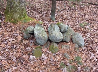 When I parked, I ended up walking for twenty minutes up and down little knolls of bedrock outcrops, as it turned out. Several of the outcrops looked like rock piles but I decided they were probably just frost broken bedrock. Then I saw some that were definately deliberate rock piles because the cobbles were not all of the same material as the bedrock.
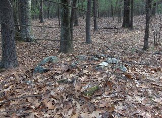
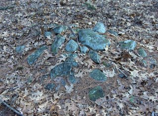 What is in these woods seems too fragmentary to get much of a feel for what is going on but there was something here. It would be worth exploring more systematically - when I am not on my way home from an earlier walk.
 Here is a detail of the near pile:
  When I parked, I ended up walking for twenty minutes up and down little knolls of bedrock outcrops, as it turned out. Several of the outcrops looked like rock piles but I decided they were probably just frost broken bedrock. Then I saw some that were definately deliberate rock piles because the cobbles were not all of the same material as the bedrock.
 What is in these woods seems too fragmentary to get much of a feel for what is going on but there was something here. It would be worth exploring more systematically - when I am not on my way home from an earlier walk.

