 I usually do not pay close attention to stone walls. What is there to see? What is there to say? Someday, someone has to take the subject seriously and really get to know the different construction styles and different topographic settings and layouts that will (I hope) make it easier to tell the difference between a more recent versus a more ancient stone wall. And I don't mean that Thorson stuff (here or here) which manages to miss the main story. But on the other hand, sometimes the walls seem pretty integral to the place, the place seems to include the ancient, and it all seems worth reporting on together. So, I give you a flat hilltop in northern Fitchburg, uphill from Falulah Brook and the Wachusett Tradition mounds along the brook. [A reason for all the "activity" in this area is not hard to guess. Look how all the brooks come together here at the center of the map fragment.]
One mechanism for capturing site layout:
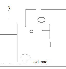
Correcting a couple of errors in this stick placement, I get a layout something like this, with walls represented by straight lines and rock piles/mounds represented by ovals:

(Hardly survey quality!)
Let's look at some pictures.
I came up from the east and first got curious seeing the tall squared off wall end at the northern end of the "T" on the right and realizing this was a short stretch of wall:
 From the other side:
 Here is a short(er) stretch that extends the southern stroke of the same "T":
 Here is the larger mound a few feet to the north; old from the looks of it:
 And some views of the little scatter of light colored rocks on a support boulder. This convinces me the site is ceremonial:
 [By the way: Is there a strategic use of quartz at Track Rock Gap?]
Some other artfully placed quartz:

 Placing quartz at a wall junction seems a common practice around here. Here is an old Oak tree and a bit a quartz at a junction downhill from these hilltop walls:
 Worth doing some compass measurements here.
Native American Stone Rows are really just elongated rock piles, connecting places by separating them. While those that are more recent are block like, almost as if the stones were being used like bricks, the Indian rows are made more like the rock piles, the artistic stacking, use of colored stones, and the suggestion of animal/human/spirit faces by the way the stones are placed and arrainged, more artwork. Around here I've been continually amazing at those double rows that sometimes occur at both sides of some roads that were originally Indian Trails, the ones that didn't become roads more interesting because some still have rock piles right in the middle of them.
ReplyDelete