 Have a great year.
Saturday, December 31, 2011
Rockport MA Rock Pile
Reader Mark A writes:
I grew up in Rockport Massachusetts and at the top of a hill are two large piles of rocks. I was wondering if you have any thoughts on their origin I do know the site was once the location of
a house-turned-hospital, but these are not foundation stones to my eyes. Here are some images:
http://eoinvincent.com/blog/turtle-rock/
http://harmonyclubwaltz.blogspot.com/2007/03/just-ducky-and-puzzle.html
And here is a writeup of the hospital:
http://vintagerockport.com/2011/02/14/leander-m-haskins-hospital-rockport-mass-1907/
I grew up in Rockport Massachusetts and at the top of a hill are two large piles of rocks. I was wondering if you have any thoughts on their origin I do know the site was once the location of
a house-turned-hospital, but these are not foundation stones to my eyes. Here are some images:
http://eoinvincent.com/blog/
http://harmonyclubwaltz.
And here is a writeup of the hospital:
http://vintagerockport.com/
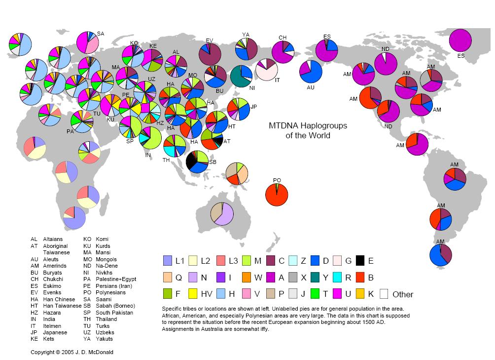
MTDNA Haplogroups of the world
[Not rock pile related]. An interesting graphic about genetic variations of Mitochondrial DNA, worldwide. [Click here]. From Cambridge's McDonald Institute.
Friday, December 30, 2011
Last rock piles of the season?
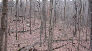
I still have later today and tomorrow to explore in 2011 but, if it doesn't snow, I also have Sunday and Monday before my long "vacation" ends. I found employment. The recent obsession with rectangular mounds in Acton continues with finds in Fitchburg along Falulah Brook and, more surprising, a find at Newtown Hill in Littleton, MA.
Definition: A Wachusett Tradition Mound is a rectangular rock pile, more than 10 feet across, with one or more hollow depressions in the upper surface. (The hollow may be represented by an external "tail"). We'll say that a rock pile is Wachusett-like if it shares the basic dimension, or if it has a hollow, or if it is not rectangular but has hollows. From the point of view of these definitions the find in Fitchburg is a typical Wachusett Tradition site and the site in Littleton is more Wachusett-like. Forthwith:
 I was not out driving all the way to Fitchburg in order to explore hilltops (smaller blue outline to the left, blogged about here) but to circle a wetland that seemed increasingly hard going. So I cut my losses and went downhill to the northeast back to Falulah brook. I should probably leave it all here with this video.
NIPMUC COUNTRY
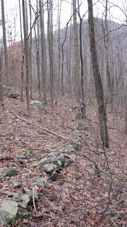
That being said, as I got down to within a few feet of the brook, I came across a damaged rock pile: It is Wachusett-like since it has "rectangular" and "hollow" attributes but is far gone. A few feet away was something much better defined, a good example of a Wachusett Tradition mound:
 These are close to other mounds a hundred yards downstream where Ashby West Rd crosses. Finding these two rock piles, extends the boundaries of the site as I knew it.
 In Littleton, I have been to Newtown Hil before and been a little disappointed. I decided to climb over the hill and stay to the right, since I never did that before. This turned out to be a good strategy. Coming down that little wet valley on the north side of the hill, I saw a little rock pile where it first started getting wet:
 Then further down, there is an L-shaped structure in the wet:
 I have found a number of such structures next to brooks. (Recall some from Forest Hill and Elbow Meadow.) Then...OOH! Big Game:
 It is Wachusett-like since it has "rectangular" and "hollow" attributes but is far gone. A few feet away was something much better defined, a good example of a Wachusett Tradition mound:
 These are close to other mounds a hundred yards downstream where Ashby West Rd crosses. Finding these two rock piles, extends the boundaries of the site as I knew it.
**************************************************************
 In Littleton, I have been to Newtown Hil before and been a little disappointed. I decided to climb over the hill and stay to the right, since I never did that before. This turned out to be a good strategy. Coming down that little wet valley on the north side of the hill, I saw a little rock pile where it first started getting wet:
 Then further down, there is an L-shaped structure in the wet:
 I have found a number of such structures next to brooks. (Recall some from Forest Hill and Elbow Meadow.) Then...OOH! Big Game:
I find it interesting that there is a main pile (to the rear) and a smaller auxiliary pile to the left. The larger one is not rectangular but has multiple hollows. It was my impression that the piles above from Fitchburg also were in an arrangement of a larger one next to a smaller one. Another view of the larger:
 The larger one was more polygonal than rectangular. This might be because of the available boulders. Here is the scene.
  These guys certainly have their feet in the water. What a lovely find! A view of the large mound from the other direction:
Closeups of the smaller pile:

 Then "down the valley" a rock pile I saw years ago. I guess I did not know, back then, to always explore in all directions around where you see something. Or I might have found the above Wachusett-like piles earlier. Now this whole valley is a big spot on my topo maps. There were several piles down at the bottom where the swamp begins, some I walked right past without noticing when I was here before. Others that I have photoed in the past.
 See how this pile looks out over the swamp?
 Another, made from large blocks of rock:
 Is this even Wachusett-like? I say "yes" because of the overall site, where each pile acquires some of the attributes of its neighbors. So, an interesting site with some small outliers and larger mounds with hollows, and an L-shaped structure - all with their feet in the water.
 The larger one was more polygonal than rectangular. This might be because of the available boulders. Here is the scene.
  These guys certainly have their feet in the water. What a lovely find! A view of the large mound from the other direction:
The outline is sort of diamond-shaped. A video from above:

 Then "down the valley" a rock pile I saw years ago. I guess I did not know, back then, to always explore in all directions around where you see something. Or I might have found the above Wachusett-like piles earlier. Now this whole valley is a big spot on my topo maps. There were several piles down at the bottom where the swamp begins, some I walked right past without noticing when I was here before. Others that I have photoed in the past.
 See how this pile looks out over the swamp?
 Another, made from large blocks of rock:
 Is this even Wachusett-like? I say "yes" because of the overall site, where each pile acquires some of the attributes of its neighbors. So, an interesting site with some small outliers and larger mounds with hollows, and an L-shaped structure - all with their feet in the water.
"The Pristine Myth"
From Atlantic Unbound (March 7, 2002)
Charles C. Mann talks about the thriving and sophisticated Indian landscape of the pre-Columbus Americas
"For years the standard view of North America before Columbus's arrival was as a vast, grassy expanse teeming with game and all but empty of people. Those who did live here were nomads who left few marks on the land. South America, too, or at least the Amazon rain forest, was thought of as almost an untouched Eden, now suffering from modern depredations. But a growing number of anthropologists and archaeologists now believe that this picture is almost completely false...Europeans who arrived early on found busy, thriving societies. When John Smith visited Massachusetts in 1614, he wrote that the land was "so planted with Gardens and Corne fields, and so well inhabited with a goodly, strong and well proportioned people ... [that] I would rather live here than any where." But by the time the colonists reached Plymouth in the Mayflower six years later, they found one deserted village after another—the Indians had been felled by European diseases to which they had little resistance."
The Interview here:
http://www.theatlantic.com/past/docs/unbound/interviews/int2002-03-07.htm
The Atlantic Monthly | March 2002

Indian agriculture long sustained some of the world's largest cities. The Aztec capital of Tenochtitlán dazzled Hernán Cortés in 1519; it was bigger than Paris, Europe's greatest metropolis.
From the article that became the book "1491"by Charles C. Mann
Whole Text: http://cogweb.ucla.edu/Chumash/Population.html
Thursday, December 29, 2011
More re Stone Huts in Colorodo
Norman Muller writes (referring to these posts):
 I found an engraving of a stone hut/chamber in the Smithsonian Institution’s Bureau of Ethnology Annual Report #12 from 1890-91 (see attached) and sent an image of it to Native American Research and Preservation in Colorado (see attached). The resemblance is striking, even though the engraving is of a structure that was found in Fayette Co., WVA, probably a thousand miles east of Colorado. The caption under the engraving said the feature was probably built as a burial chamber.
 I found an engraving of a stone hut/chamber in the Smithsonian Institution’s Bureau of Ethnology Annual Report #12 from 1890-91 (see attached) and sent an image of it to Native American Research and Preservation in Colorado (see attached). The resemblance is striking, even though the engraving is of a structure that was found in Fayette Co., WVA, probably a thousand miles east of Colorado. The caption under the engraving said the feature was probably built as a burial chamber.
"No. Nobody Found Mayan Ruins"
I thought I would take a look at what else is being said on the internet about this story of 9UN367. Perhaps this is a typical example, illustrated with a pretty map. I want to comment that the connecting of Track Rock Gap to the Mayans may be nonsense, but lets be clear about the logic. There is a site with physical characteristics that are being documented and speculated about. You cannot dismiss the speculation by quoting theory from some other sites and other unrelated facts. So, for example, Thornton is looking at terracing at Track Rock Gap and saying it is uniquely like Mayan structures. The author of the link above has nothing to say about the facts and so their argument is just huffing and puffing. By contrast, pointing out that there are lots of other examples of such "terraces" and that they are all the way up into New England and (I suppose*) Canada, employs a different critique and is, I think, a fairer argument.
*Take a look at Bayers Lake and Birchtown maps. Or is it that these sorts of maps always look alike?
*Take a look at Bayers Lake and Birchtown maps. Or is it that these sorts of maps always look alike?
Speaking of Walls and Rock Piles...
 I usually do not pay close attention to stone walls. What is there to see? What is there to say? Someday, someone has to take the subject seriously and really get to know the different construction styles and different topographic settings and layouts that will (I hope) make it easier to tell the difference between a more recent versus a more ancient stone wall. And I don't mean that Thorson stuff (here or here) which manages to miss the main story. But on the other hand, sometimes the walls seem pretty integral to the place, the place seems to include the ancient, and it all seems worth reporting on together. So, I give you a flat hilltop in northern Fitchburg, uphill from Falulah Brook and the Wachusett Tradition mounds along the brook. [A reason for all the "activity" in this area is not hard to guess. Look how all the brooks come together here at the center of the map fragment.]
One mechanism for capturing site layout:

Correcting a couple of errors in this stick placement, I get a layout something like this, with walls represented by straight lines and rock piles/mounds represented by ovals: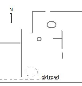

(Hardly survey quality!)
Let's look at some pictures.
I came up from the east and first got curious seeing the tall squared off wall end at the northern end of the "T" on the right and realizing this was a short stretch of wall:
 From the other side:
 Here is a short(er) stretch that extends the southern stroke of the same "T":
 Here is the larger mound a few feet to the north; old from the looks of it:
 And some views of the little scatter of light colored rocks on a support boulder. This convinces me the site is ceremonial:
 [By the way: Is there a strategic use of quartz at Track Rock Gap?]
Some other artfully placed quartz:

 Placing quartz at a wall junction seems a common practice around here. Here is an old Oak tree and a bit a quartz at a junction downhill from these hilltop walls:
 Worth doing some compass measurements here.
 Colorado Turtle
Reader R. Sirois writes (comparing to Crestone CO structures mentioned here):
I posted these on facebook because of the similar structure minus the opening. You may use them as you see fit. This is in a location in Standish, Maine.


I posted these on facebook because of the similar structure minus the opening. You may use them as you see fit. This is in a location in Standish, Maine.


Additional Pictures from 9UN367
Reader DG Merritt writes about the ("Mayan") Track Rock Gap:
Here are some additional images from around 9UN367, a very rich and intriguing site:

Here are some additional images from around 9UN367, a very rich and intriguing site:
1_Wall13.jpg: Prehistoric wall in middle left of image, as seen from adjacent hillside. I believe this wall corresponds with Wall 13 in the Loubser and Frink paper. There are additional stone features at middle right.
 2_Wall13.jpg: Closer view of Wall 13, with intrepid explorer Kevin Scallions. Track Rock Gap petroglyph site is at base of peak in background.
 3_largeCairn.jpg: Large stone cairn at 9UN367, south of Wall 13, with life-size dummy provided for size comparison.
 4_stonecircle.jpg: Stone circle or collapsed cairn at 9UN367, with additional linear features in background.
5_nearLgCairn.jpg: Kevin Scallions at stone features near large cairn.
 6_Wall13.jpg: Another image of Wall 13, one of many linear features at this site.
 6_Wall13.jpg: Another image of Wall 13, one of many linear features at this site.
I would like to point out that far from suggesting a "Mayan" connection for the features at this site, the Loubser and Frink paper says "Bearing in mind that 9UN367 is located at the headwaters of the Tennessee Valley it might have closer ties with the Tennessee and Kentucky area than with the Georgia area to the south."
...By the way, thanks for introducing me to Tommy Hudson a few weeks ago. We've had some interesting conversations.
Wednesday, December 28, 2011
Obsessing over rectanglular structures - more short walks from Piper Rd Acton
 While I was reviewing the map of Piper Rd (blogged here) I noticed another little landform to the south that also was surrounded by water and looked worth exploring. So I snuck behind houses over there on Christmas day (after getting the roast in the oven) and did the "tour de ridge" from Piper Rd over to School Street. There were little rock piles along the northern side of the landform (middle blue outline) much like at the ones at the earlier Piper Rd site:
 This was the firsts I found, and I called it my "Christmas Pile", as it was like a present:
 More interesting to me was the larger somewhat rectangular pile at the easternmost extremity of the landform, a larger pile that might have been a "Wachusett Tradition" item. It was perfectly placed for it:
 Is this a pile with a tail? I was more or less visible from houses and did not stick around to take good pictures.
After doing this "sneak" I went over to the west side of the road to the legitimate entrance to the Acton Great Hill Conservation Land. Along the red trail in there there is one curious rock pile:
 This could also be a rock pile with a tail. Also along the red trail there is an earthen rectangle with an inner stone lined hollow:
(sorry lousy picture)
 Inner hollow:
 I also thought I saw another, so faint there is no point showing the picture. So either this little part of Acton is full of (a count 4) rectangular Wachusett Tradition piles - rectangular mounds with hollows and/or tails; or perhaps it was nothing. I know I am obsessing about these sorts of rectangles.
Some History of Rock Pile studies at Track Rock Gap and other sites in the Southeastern US
I asked Norman Muller to fill in some of the history of rock pile studies in the southeast. He writes:
In the late 1990s, probably when I contacted the University of Georgia Anthropology Department about Philip Smith’s 1962 article on prehistoric Georgia walls, someone in the department told me about Carey Waldrip’s research at Track Rock Gap. At that point, he and I maintained correspondence about his research of the terrace wall site at the Gap. This area is east of the petroglyphs at the Gap, for which the gap is named. In the 1990s, Carey, a native of Blairsville, GA, discovered the extensive stonework at the Gap. And then, in the late 1990s, he contacted Tommy Hudson, a developer, who then contracted Jannie Loubser to survey the site. Loubser at the time worked for New South Associates, an archaeological firm in Georgia. He was trained in South Africa, and is an international rock art specialist. Around 2000 Loubser surveyed the site and prepared a report, which is now available online.
In November 2002, while in Georgia attending a symposium at the University of Georgia, I drove to Blairsville to meet with Waldrip, who guided me through the wall site at the Gap, and then to another cairn and wall site a mile or so south of it. The majority of walls he showed me were low and generally parallel to the contour of the slope. The slope at the gap is rocky, the soil thin, and hardly desirable for agriculture. Plus, there were few streams or springs present to suggest that the walls served to dam or control water for an agricultural purpose. To my way of thinking, they were constructed for an entirely different function – perhaps ceremonial.
Since meeting Waldrip, I have corresponded intermittently with Loubser, and he has sent me pdf reports on the sites he has researched. Also, about four years ago I met Tommy Hudson at a meeting of the ESRARA (Eastern States Rock Art Research Association) in northwest Georgia. He funded the initial research of the Track Rock Gap site. Also, I have met and been in contact with Harry Holstein, an archaeologist in Alabama, who has researched wall sites similar to the one at Track Rock Gap.
Thornton’s recent hypothesis that the walls at Track Rock Gap are Mayan lacks credibility, judging from what I know about the site and the individuals who have studied it. If one reads what Thornton has written and compares it with reports by Loubser and Mark Williams (on Kenimer Mound), then it becomes clear that Thornton’s research is sloppy and that he modifies what others have written to support his own beliefs. Loubser’s research, however, is first class. He not only is a fine archaeologist, but he also has a deep understanding of Indian cosmology and mythology, which he incorporates in his reports. His article on Judaculla Rock in the journal Time & Mind (“From Boulder to Mountain and Back Again: Self-Similarity between Landscape and Mindscape in Cherokee Thought, Speech and Action as expressed by the Judaculla Rock Petroglyphs. Time & Mind 2 (3), 2009, 287-312) is exceptional not only for its sensitive perception and interpretation of Indian rock art, but also how knowledge of Cherokee history and beliefs amplify its interpretation.Near Crestone, Colorado,
there are four intriguing stone 'hut' structures......

Two are very 'turtle' shaped.

We would like to hear from you if anyone knows of similar structures, their uses, age, etc.
Native American Research and Preservation, Inc. @ http://stonequest.org/StoneHuts.aspx
Subscribe to:
Posts
(
Atom
)
