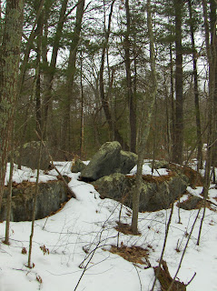
That is Rt 110 in back there.
We crossed the road, then
crossed the frozen wetland, and got to the island. At last.
The original picture from a distance was surprisingly good. Compare it to this:FFC pointed to the quartz in the most prominent middle pile.
Note there is another rock pile beyond the one behind FFC. That makes four in a row and the impression is they would be visible and evenly dividing the view from over there on the western bank of Bowers Brook - where there seem to be several places to see the whole panorama.
Here is a detail of the quartz:
We also noticed a little aperture (the quartz is on the right at the edge of the photo):
One of the smaller piles also had an interesting detail. It is something like a Manitou stone, hanging over a small niche in the pile.
Also the small rocks scattered around did not seem entirely innocent - meaning they had some structure too. It is a bit visible here:
and here. Note the diagonal line and another line going to the right of the tree (in the foreground) and straight back to the pile just visible in that direction.
FFC, in his usual way, poked around and noticed a few more buried rock piles at the southern edge of the outcrops. Here is the view south:
And some of the other rock piles:
A big rock-on-rock next to the main brook:
A pretty place we probably won't see again and leave it now, home to the beavers.


Wow, nice.
ReplyDeleteHow nice to see this up close!
ReplyDeleteI think the old road was Lovers Lane and the current Rt 110/Still River Road was added across the marsh in the early 1800s. The dam to the south of the island was also 1800's. In earlier times, this area may have been drier and seasonally flooded. One reference says there was a cornfield here.