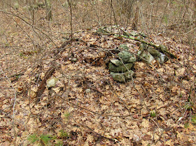
On the way to the Saturday lecture, I thought it would be nice to stop somewhere and explore for rock piles. Franklin State Forest seemed a likely spot:
I particularly wanted to get to those swamps part way up the main hill (below the "R" and the "T" of the word "FOREST" on the map above). When I got to those swamps, I found lots of rock piles. They were old and deeply settled into the dead leaves and I spent an hour taking pictures of the dead leaves. But I still got a distinct impression of the place - something about the arrangement of the piles; something about the hints of quartz in the walls and some of the piles; something about the topography along the edge of wetland and in the floodplain of a brook.
I'll show the pictures I got in a moment. You can imagine I was looking for large mounds with hollows in them. I found them at the end, on outcrops that overlook the swamps from the east. The whole place put me a mood that continued the next day in Fitchburg; where I saw similar hints of quartz, placement in floodplains, and larger mounds on outcrops. I felt as though I spent the weekend visiting with the old ones. First in Franklin and then in Fitchburg and the mood lasted through the weekend. But the features in Franklin seem older. They are more settled - more "disappeared" into the ground.
I parked at the end of Lorraine Metcalf Rd and hung a right at the trail-head. Got a bit mixed up and ended by climbing to the top of the hill, to the water tower. There I turned back downhill and needed a compass to assure myself I was headed southwest. I stumbled off trail in that direction, down towards the swamp. Seeing this made me want to cross and look at the opposite slope:
It reminded me a little of the approach to some of the sites shown by Larry Harrop. So I went across that wetland and part way up the next hill without seeing anything. In retrospect I probably was walking past buried rock piles because it was only on the way back down that I saw a pile up on a boulder, leading to me noticing all the other little ones under the leaves:
Here is a typical pile from in there, at the lower edges of the western slope, beyond the swamps:
Ironically, as I look at the pictures of these formless piles, I find some of them do have a bit of form:
(I think this has the same form as the previous).
So I took lots of pictures like that, then crossed a stone wall. Usually walls enclose a site but I continued to find more buried piles - and more deeply buried. No point in showing more except maybe one of several that are actually in the trail:
The piles were separated from the wetland by another wall. Here is a pretty piece of quartz:
and here is another, next to an entrance. The wetland is off to the right:
closer:
Invited back to the brook, I spotted three in a row beyond:
The last of the three was quite nice:
Then I was in a flat floodplain area with wetlands on either side (east and west). And the mounds got bigger but they were still badly settled.
Here is an interesting structure: kind of a snakey line of rocks, with a small "circle" at one end, quartz in the middle:
From the other end:
The piles really had their feet in the water:
Many of the piles had one larger rock:
Then I exited to the east. The piles and mounds were well integrated with the stone wall. Here is an entrance a few feet from the previous:
I saw larger mounds on the outcrops, heading out, so I'll tell you about that later.


No comments :
Post a Comment