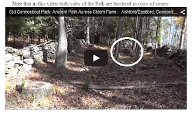
I’m getting a lot
of virtual mileage out of those CT Path Videos I linked to a couple days ago
(Indian Trails and Rows of Stones) while outdoors continues to be not only snowy
and icy but also sort of cold. I find it sometimes satisfying following Jason
along those rows of stones but also frustrating when I think I spot Something
Possibly Ceremonial – like those boulders at what might be openings that might
be a possible serpent. I see them in the distance but as he gets close he
swings the camera away to the opposite “stone wall” he keeps telling us is a
testament to the skills of the people who showed up in 1620 - along an Indian Trail
known to be a “couple thousand years old” (Herman Bender - Personal
Communication 01/15/15). Using a law of Parsimony as a guide, a good question
might be “Was all that stone work more likely built by the group of people who
have lived in this part of the world for the 3% of the total time of human
occupation in the area or sometime during the other 97%?” Another way to say
that too is for me to paraphrase and mangle up Lucianne Lavin’s question
(possibly to Tim Ives) during the Stone Feature Roundtable: “Who do we think
would have constructed a stone wall if at the end of that stone wall you find there is a
boulder that might represent a snake’s head?”
It also turns out the actual true CT Path is
in dispute: there’s more trails suspected and there other known paths all over CT (and elsewhere) – Are there similar stone features
along those trails?
(Best viewed if you open another window or tab)
And I should have
thought to have chosen a different preview picture at Rock Piles but I thought the map was interesting - and actually I was surprised at this that showed a a preview at
because this is how I see it there:
On my 'compose a blog screen' the image looked like it
does above in the first photo, a rock pile or Stone Mound or even Carin if you are of Scottish
descent and really want to use this European word when these probably a
perfectly good Nipmuc word to use, right in the middle of the Path:
So now I’m thinking that it might not be too cold to stop along a spot where Peter, Norman and I
once stopped after the NEARA Fall 1998 Meeting, up by the Bethlehem Town Dump.
I would think that I would have shown them showed something similar inside that
double stone row construction, often described in stone wall literature as “cow
paths,” but the truth is I don’t remember if I did. Maybe there’s a photo from
that day of that stone pile – and maybe it really isn’t that cold today; I just may take a chance and get an image that might be remarkably similar...
Update: http://wakinguponturtleisland.blogspot.com/2015/01/former-stone-mounds.html
Update: http://wakinguponturtleisland.blogspot.com/2015/01/former-stone-mounds.html


I live where the Old CT Path cuts through the word Nonnewaug on the western end of the map used in the post, about where a modern map would show you CT RTE. 6.
ReplyDeleteI have a similar experience watching TV shows or movies with woodland scenes. I am 1.5 hours into "Hillbilly Blood" which is on Cold Mountain in North Carolina and, if I am not much mistakes, I have already seen rock piles 3 times in the background.
ReplyDelete- Once was a low outline
- Once was a "new" vertical stack
- Once was a huge old mound with a hollow.
If correct, these are familiar varieties from up in MA.....OR I could just be seeing things
Up by the dump, those stone piles are disturbed and dismantled - maybe "borrowed" to somewhere else...
ReplyDeleteSome "cairns" at about 8:45 minutes into it:http://youtu.be/KgGKPzSn748
ReplyDelete