[From reader Hazel over several emails]
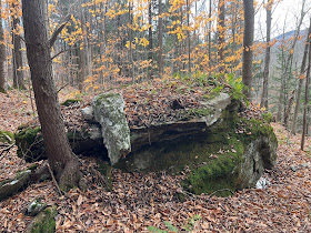
I'm including for fun, some of my favorite images of the stones I have 'discovered' in Honey Hollow, VT. I have also seen the impressive sites at Wolfrun/West Bolton(noted by N Muller and NEARA) and I think these sites are related, being directly north/south of each other, with the Winooski River between them. I shared my findings with Mike Luoma, who recently visited and feels these findings are genuine. I am working on a map - not counting stone rows, I have over 20 + different stone formations noted. Everything from 'typical' stone prayers, to prominent directionals, niches and 'stone spells' as you call them - which I agree seem different then the prayer-type piles. I read Manitou for the first time this summer and now suddenly, I cannot seem to go ANYWHERE in the woods without finding things.


Some more from Honey Hollow…
And this I found high above the colonial clutter, on the western ridge of Honey Hollow. I couldn’t ignore the 315* NW orientation, as if aligned with summer solstice sunset or winter sunrise. I know my boyfriend can’t wait for me to drag him up there again on 12/21 at 6 am LOL
And these are some of the cairns at Wolfrun, directly north of Honey Hollow…
I've always noticed them but only recently did I learn that they may have some significance. State archaeologist Nick Bellantoni came to this area 22 years ago because of an Indian burying ground in the area. I had him come to this area on my property and he said it was probably an area of Indian settlement: A terrace with an adjacent steep-ish slope. There is a circle of large flat stones, and there is a spring and a small wetland very nearby.
This last one is very large, maybe 15ft or more, on a hillside. The cairn is on adjoining land trust land.
***
I took more pictures today, sent to you as files, of the large mound which, lol, I over-estimated to be too tall. I'd say it's only about 7-8 ft or a bit taller. The mound is at the bottom of a steep-ish slope (elevation drop of 50 feet over 300 feet on a hill which is like a symmetrical bowl, on an upland terraced site, the bowl being a large extended triangular mound at the base of it). Included is a small "cave" on the mound which extends in a couple of feet.
This mound is in a straight line with the humanoid-fish-turtle like structure that is roughly 300 feet away due around 10-15 degrees degrees west of north, so I guess true magnetic north.
If you could guess, I'm interested in the possible date of these structures. I always thought the mound was colonial and the low effigy was a place where someone buried a pet, but every time I passed I thought it was way too elaborate for that.


Picture #5 is quite interesting. Note the symmetry of the pattern of cobbles, sitting in an old spilt rock, which looks a bit like a hand holding something.
ReplyDeleteWhat is curious is the two long rocks in front of the pattern. They have the same shape: a scallop taken out of the end. That shape may be familiar to stone tool enthusiasts.
That feature in #5 looks to be a split-filled boulder, it's at the base of the site. The larger boulders making up the feature have a similar orientation.
ReplyDeleteI'd be very interested to see the map! Also, if Hazel or Mike can (privately if that's a concern) send me GPS coordinates I will be able to add this site to my inventory.
ReplyDelete