Tuesday, April 17, 2012

Scott Rd etc parts c and d

With respect to the map here. There were various things to be seen in the woods downhill and east of the spot I marked under the power lines at "b". Including scattered structures that were part of that site and revealed it to be located near a spring (cuz they were downhill where the gully was more noticeable)Then I got to a lower road (not sure which dashed line on the map is properly called "Scott Rd") and saw a nice foundation:Continuing eastward on the road, I saw a rock pile a few feet downhill (the third place with rock piles of the day) and, suspicious of solitary piles, went down the slope to make sure it was as isolated as it seemed.
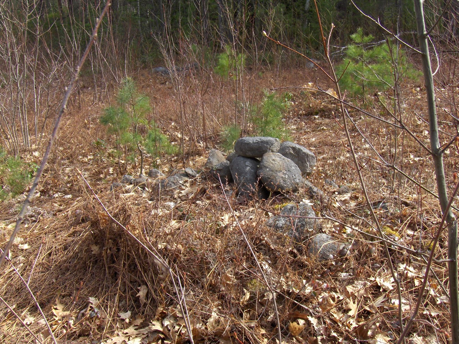
On the contrary, there were six or more rock piles nearby but so smeared and covered with leaves as to be more or less invisible. There are at least three here:This pointed me downhill and I continued to see rock piles in the woods in that direction. I got to another little structure (shown earlier)and then a short stone berm:and a few feet downhill, a short stretch of wall with one bend in it, quite different from the berm:Then another little structure:
Then I got to a third road near the bottom of the hill but also parallel with whichever one uphill is called "Scott Rd" and just below it: a beautiful example of a rock pile with a hollow - a Wachusett mound:The view:From the side:

As you can see, it is built against a boulder and is roughly rectangular or, at least, oblong. Here is a view from below:
As I mentioned in the video (#3 here) there was quite a lot quartz and white feldspar on the surface of this pile.I want to comment that both large "mounds" from sites a and b had an extension consisting of a small rectangular pier sticking out from a corner of the main mound. Either this mound at d is of a different style or perhaps the boulder served the same purpose as the extension.

Monday, April 16, 2012

Scott Rd and the northern side of Flat Rock Hill - Part b

With respect to the map, I continued eastward along Scott Rd till I was underneath some power lines (at "b" on the map) and saw a rock pile and then a whole field of six or so.I was wondering "where is the big mound that goes with these?". It was in the trees below. A very curious shaped pile:See the rectangular extension towards the viewer. Awfully damaged behind:

Scott Rd and the northern side of Flat Rock Hill - Part a

My eye was attracted to this area on the map before, and the first time I visited here, a few weeks ago, I stayed to the right as I came in from the west on Scott Rd. That brought me to the back of the Audubon parking lot (see here). Later, I realized I had never gotten to a spot (near "a" above) that looked good during planning. So I thought I should go back and check it out. Later I could explore some more of the northern side of the Flat Rock Hill. So, coming in from the west, the same way as before, I stayed sharply right before "a" just behind the houses, so as to get to the top of that little hill there. I saw some rubbish, and then just what I was hoping for: a rectangular mound with a hollow, looking southeast over the water that fills "a".
Photo conditions were not good (too much light and brush cover) but to the left of this photo there was an extension of the pile - a "tail".
The pile from below:
and side (now the extension is on the right):In the second picture, you see these rocks towards the middle:closer:I noticed two satellite piles. One to the side:The other behind:After taking a few pictures I explored around the rest of the little hill, saw nothing, and returned to Scott Rd.

Burning to restore a Cultural Landscape


Integrated management strategies used to protect cultural landscape of Bald Hills
      By Terry Hofstra
I've been looking for an image like the one above for a long while now. I "drew" my own a while back that did much the same and drove game as well:
http://wakinguponturtleisland.blogspot.com/2010/09/game-drive.html

Friday, April 13, 2012

Lunch break find- Crude quartz artifact

Today I had a chance to get out for a few minutes at lunchtime and check out a little spot in an area where I have found arrowheads. I picked up this crude little quartz artifact. It looks like it has some damage to the "ears" at the bottom and it is asymmetrical and not very aerodynamic-looking. In my opinion this is not just a chip or flake but rather a definitely worked piece that is or was a tool. I might guess that this could have been used as a knife or scraper, I suppose it could also be a crude projectile point, maybe something unfinished, or a reworked point that could no longer be resharpened and was discarded.

Here it is with some triangular arrowheads I found around the same area in the past. It is similar but not the same. The material is the same and the flaking varies on the arrowheads, some are finely flaked, others more crude.
Any comments on this find would be welcome. It is nothing spectacular or impressive but it is my best find this month, any find for me is a good find, and it is a special treat to be able to find something during my lunch break during the week.

Scott Rd: the videos


A letter from Norman

When you mention “cavities” below, I thought of one of the engravings in a Smithsonian publication of a stone mound in West Virginia (attached). You must know that I’ve found a number of “tails” or extensions of the large platform cairns I’ve documented in Vermont. And that all began with a single platform cairn at the Oley Hills site in Pennsylvania. Attached is an image of that “tail.”

A letter to Norman

Writing to Norman Muller:
I believe the "pyramids" are burial mounds. The "hollows" are because the body was surrounded with branches and organic materials which, decomposed, have fallen in. I have examined the inner surface of several hollows that were well faced with squared-off stones, indicating the hollow is deliberate and (to me) clearly part of the initial mound design. It is neither a "thunder bird nest" nor a disturbance from vandalism. It is simply a collapsed inner chamber. The occasional "tail" was an open topped part of the mound. I speculate that this had a mortuary function auxilliary to storing the final remain. Perhaps it was for de-fleshing.

Many of the mounds have two hollows, indicating a paired burial. Some have one, some have a very large hollow suggesting a group burial. I have seen several sites where there is a mixute of several one-hollow piles together with one "group" burial. That sort of thing suggests a hierarchical tribal structure.

I do not believe the satellite mounds are for "veneration" but, rather fall into the category of what I call "marker piles". They usually have one vertical face and are usually arranged carefully, not at random, about the larger mound. Interestingly, often the mound is easy to miss, and people only notice the satellite piles. I also believe that late in the history of these things, the burial mound was abandoned but the marker piles continue. I think they are for astronomy and believe they are fundamental to the soul's transfer into the heavens.

Thursday, April 12, 2012

Mills Mound Comparison

I took another look at an image from the “Mills Mound” Blog:
In the bottom right hand corner were two features I look for in photographs of what are often labeled as “Cairns” or “Mounds” – a possible turtle head stone, a V-shaped beak and an eye visible in this one, and a right foreleg. Above it as well are stones that represent the scutes of a turtle carapace or shell.
I compared it to my friend Norman Muller’s photo of what has been described as “a well formed turtle cairn” in North Madison CT, reversing the image to show what, to me, are the similarities between the two:

And browsing around I found a different Mills Mound Cairn that resembles the front view:


I think this is Dan Boudillion photo of a similar smile, but on a solid stone carapace turtle:
We don't know the mood of this box turtle effigy:

Wednesday, April 11, 2012

More on Scott Road...

coming soon.Truly, I am blessed by woods with almost limitless rock piles.

Tuesday, April 10, 2012

Walpack Ridge Trail Cairns

Reader Bob P writes:
A year or more I sent some pictures of the rock piles I saw on a hike from the Walpack Center to Thunder Mt. on the Walpack Ridge Trail. Last week I went back to hike the other trail and I had the GPS with me so I included a map. The hike starts on the Military Road Trail which has quite a history and the Walpack Ridge Trail is off of that. Then I took the other part of the Walpack Ridge Trail back to the Military Road Trail and went back to the Walpack Center. Here is a link about the Military Road Trail:
There was lots of activity over the years. I even found some large clay pipe pieces in the creek near the bridge to get to the carns.
I've hiked in lots of places in the Delaware Water Gap NRA, from the Gap up to High Point. I've seen many old roads, rock walls, dams, etc., this is the only place I've see rocks piled up like this. Here is a link to the slide show I just sent out of the hike, I only put one rock pile on it because I had so many photos to include.

Stone arch tunnel from Andover MA

Reader Patrick M writes:
Have been to this site many times as it is my sisters back yard. It is on a crest of a hill looking towards a body of water. There are 2 caves as this, and also a pass through. It is a fun place and some older research suggested Indians, but in viewing it appears more to be more modern. Circa 1840's-1860's, maybe a farmer used this for storage or a hunting shelter?

Green time's a comin'

Feeling the need for some color.