
Monday, October 15, 2012


Sunday, October 14, 2012
Back from Belize
Where do I start to tell you about an incredible experience that almost feels as if I dreamed it?
I had all these choices of Maya sites to visit in Belize, Lamania and all the rest on the mainland, but instead I called Jan Brown, pictured below, and visited a relatively undeveloped Maya site called Marcos Gonzalez Archaeological Reserve, about four or five miles south of the hotel my wife Roberta and I stayed at on Amergris Caye.

The site - the National Park, I should say - is a human made mound, with other mounds on it, combinations of stones of many types, shells of many types and an endless array of artifacts that I walked on with every single step I took, fragments of pottery and projectile points, pieces of jewelry and human bones that bound together the "black dirt" called Anthrosol.
Here's the official website for more info - I just wanna post a photo or two for now:
(A Google search will bring you (and I) more information if you like, but for now, here's some photos:)


(Jan points out the first of many human bones to me above, and a close up is below...)


Saturday, October 13, 2012
Russian Geoglyph
Not so rock pile related but I find it fascinating. To me this is like a ceremonial pathway: See the spot where someone took a short cut? From here on Yahoo News.


Friday, October 12, 2012
Thursday, October 11, 2012
Rt 16 Ossipee NH
Rob Sirois writes:
Last spring on my way to the NEARA Meeting I thought I had seen something next to the road in Ossipee, New Hampshire. It was on Route 16 a few hundred feet north of a furniture store well known in that area. I had an opportunity on Friday to take the hour long drive to do a short investigation. Two structures could be seen atop a small knoll next to the road. One was a boulder with a pile built onto it and the other a split boulder filled with rocks. Both showed some damage from the past widening of Route16.


 On top of the knoll, not far from the two
structures is a small family cemetery which has signs of still being
looked after.
 I looked about for more and found another boulder with
some rocks on top of it. Deeper into the woods were what could have been
mounds or just rock dumps. Some had brick tossed onto them, others look
as if kids had dug into them to build “forts”; nearby were some small
well shaped rock piles.
 On the way back to the truck I crossed a small
swamp and made my way to a rock wall that I knew lead back to the road.
Just on the other side of that wall was a lozenge shaped mound about
four or five feet high, twenty feet long and ten or so feet wide. It was
hard to get a good picture of it because of the thick growth of young
trees. It had something of ring of larger stones approximately the size
of breadboxes along the outside and in-filled with smaller stones.
 Roughly oriented from north to south; the southern end was the highest
point in spite of a hollow depression in it. The mound had taken some
abuse from some recent logging activity and judging from the remnants of
a parlor stove and other debris; it was used as a dump.
 A few miles up
the road is the Indian Mound Golf Course. The mound itself is an
unassuming hill near the 13th fairway. It once contained a body with
concentric burials radiating out from it. Also in this area was a Native
American Fort at what is now called Bear Camp. I’m sure that there’s
more to be found in the Ossipee Valley Area.
Last spring on my way to the NEARA Meeting I thought I had seen something next to the road in Ossipee, New Hampshire. It was on Route 16 a few hundred feet north of a furniture store well known in that area. I had an opportunity on Friday to take the hour long drive to do a short investigation. Two structures could be seen atop a small knoll next to the road. One was a boulder with a pile built onto it and the other a split boulder filled with rocks. Both showed some damage from the past widening of Route16.


Wednesday, October 10, 2012
More on stone mounds from Madison ME
With reference to the place described here, the owner Joshua W. sent some pictures. He writes:
Forwarding you the pictures I took of the site today, which I sent to Norman Muller earlier. ... Just let me know when is convenient for you and I can be around. We can take a spade out there and maybe clean up the quartz or the stacked rocks a bit to see the extent of the site, and if it is even man-made, or just naturally occurring.


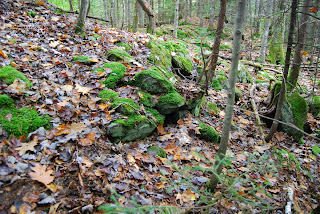


Forwarding you the pictures I took of the site today, which I sent to Norman Muller earlier. ... Just let me know when is convenient for you and I can be around. We can take a spade out there and maybe clean up the quartz or the stacked rocks a bit to see the extent of the site, and if it is even man-made, or just naturally occurring.


Also, Norman mentioned Red Paint People earlier, which I
find fascinating. Some of the rocks pictured in the bedrock do have red
stains, but these are probably moss or lichen or something. I call it
bedrock; my father believes they are large boulders from the Kennebec
River bed eons ago, or glacial erratics. My little sister is looking
for graduate studies in preservation and conservation, and just
participated in her first dig at a site in New Hampshire. She wrote her
thesis on Father Rale, as he is referred to here in Madison (actually,
the colloquial reference here in town is Father Ralse). She is
absolutely thrilled we may have a site here, whether it be Abenaki, Red
Paint or whatever it may be. She is still looking for the original text
of Father Rale's writings from when he was in the area because she finds
the translations inadequate. She believes they are in some Jesuit
archives somewhere, or in the possession of his descendants. The are
definitely in Europe, which limits her ability to find them. The
Norridgewock village is so close to where we are, Father Rale must have
been familiar with the area, and she hopes to find the site mentioned in
those writings.
Tuesday, October 09, 2012
Fall colors at Leominster State Forest


Orkney is NOT the center of ancient Britain
[Not rock pile related]. See here. I read the text waiting to see the answer to why Orkney is the "centre". But never saw it. The whole discussion of megaliths in general and Orkney in particular is utterly lacking in basic common sense. Let me rant on:
I did not see a discussion of Orkney's inaccessibility. Orkney is not the center of Britain. It is, in fact, the very furthest ends of the earth. How are people supposed to get there? Why would a religious center be at the ends of the earth? I tell ya what: No mention of boats in the article [yes there was in relation to how the neolithic farmers got there] but Orkney is at a major crossroads for maritime cultures. It is the center of the Atlantic coastline of Europe. This escaped the authors' attention.
I did not see a discussion of how real farmer's actually decide to plant their crops - not by calendar! Instead the "neolithic farmer" is portrayed as a sophisticated mechanical engineer, who also needed special help deciding when to plant.
Apparently Alexandre Thom thought the archeo-astronomy indicated moon worship. If there is any such indication it would, I think, be a rare focus for farmer's religious beliefs - as the moon would play little role in the health of a farming community.
Saturday, October 06, 2012
Turner's Falls Airport - Determination of eligibility for listing in the National Register of Historic Places
via Norman Muller:
http://www.nps.gov/nr/publications/guidance/TurnerFallsDOEDecision-Redacted.pdf
Adding: interesting how the state officer thought the site was not eligible but the federal officer thought it was.
http://www.nps.gov/nr/publications/guidance/TurnerFallsDOEDecision-Redacted.pdf
Adding: interesting how the state officer thought the site was not eligible but the federal officer thought it was.
Friday, October 05, 2012
Rock Piles About a Mile From Father Ralse/Abenaki site
Reader Josh W. writes:
Recently, I identified two mounds on my families property (mounds are approximately at 44°48'43.99"N, 69°53'16.
Anyways, these two mounds are well overgrown with
trees and bush, but the mounds appear to be made up of slate-like pieces
of rock stacked up, with a very large, and unique, pile of quartz
between the two mounds. The quartz is unusual, as, while it is present
here or there on the property, this one spot has loads of it. The mounds
are clearly man-made and are near some bedrock outcroppings, which are
also uncommon on the property. Some of the slate appears to be stacked
atop bedrock (or large traveling boulders, deposited during the last ice
age and only appearing to be bedrock).
My home is about a mile from well documented native populations, including the massacre of 1724 (and the events surrounding http://en.
UPDATE: There is no powerline expansion happening here, the land is currently Weston property and has been since homesteading days about 200 years ago (our house is 5 years from our bicentennial). Its kind of a strange subject talking about the land which the was given away to our family by the State of Massachusetts, in connection with the previous inhabitants which hadn't really been gone from the area when the land was deeded. The earliest of our ancestors settled in 1771, less than 50 years after the Rale incident and in living memory for people at the time. Strange indeed.
UPDATE: There is no powerline expansion happening here, the land is currently Weston property and has been since homesteading days about 200 years ago (our house is 5 years from our bicentennial). Its kind of a strange subject talking about the land which the was given away to our family by the State of Massachusetts, in connection with the previous inhabitants which hadn't really been gone from the area when the land was deeded. The earliest of our ancestors settled in 1771, less than 50 years after the Rale incident and in living memory for people at the time. Strange indeed.
The area is not far north of the falls in Madison
and the well known Norridgewock village, and just south of where the
Carrabassett River empties into the Kennebec. The mounds are only a
couple feet away from the old Caribou Trail, a trail which, according to
our ancestors and other oldtimers in the area, was the caribou
migration trail where they would walk pretty much single file through
the area, year after year, the ground so well-trod that parts of it are
still thought to exist today. At least that is the local mythology, but
certainly it is true to some extent.
In addition to the mounds, there are a number of
other possible features in the area, along a run of exposed bedrock, the
only such exposed places in the nearby area (on our property, anyways).
We never had a brickworks on the property, that I know of, but there
are hematite-rich very red clay deposits only feet away from the mounds I
described, and some evidence of a small dam, which may have been when
the area was used as scrub pasture, too wet in patches to plow, which
most of the rest of the property underwent over the years. Now it is
timberstand.
There must have been an enormous presence of people
here over the millenia, with the falls and the caribou trail which you
can still find loads of arrowheads and what not around. I can't believe
it never occured to us to check for ancient structures, but the area has
been so overgrown in the past 100 years since large-scale agriculture
died down, that things have been hidden from view.
Thursday, October 04, 2012
West Palmer Hill and behind the Fitchburg-Westminster Landfill

Since this hill is basically one of the Manoosnocs, I hoped to find the same kind of sites I found east of Notown Reservoir. I call this area the "Capital of the Inland Empire" because of the numerous large rectangular mounds. Mostly I find them up high on the shoulders of the hills but mindful of more recent discoveries, I have also started exploring along the edges of wetlands - looking for those older piles. So here, my strategy was to circle the edge of that "Sawmill Pond" (A to B) then cut diagonally up the hill and come back along the higher slopes.
From where I parked, I cut down through the trees and it was a bit heavy going and as soon as I got to the edge of the water I saw an arrangement of rocks that was not quite natural but not quite clear as a structure. There were several instances of arrangements of rocks in a row, suggesting an outline.

[It was so dark in there most of my photos are worthless. I tried as hard as possible to hold my hands steady but, as it is, I am wondering when I'll get to enjoy some better pictures from this new camera. It has been raining every single weekend since I got it. And it was raining throughout this walk.]


Over and over throughout this walk I was seeing collections of rocks that might be random but probably were man made structures. I think they are just too old to keep their shape. Also I keep having a sneaky thought that most people would see nothing but random rocks.
So I crossed the smidgeon of brook there and continued counterclockwise around the pond, finding one or two more of these hints of structure. I had a tough stream crossing, nearly losing it, and then headed uphill on the diagonal.

[pause]
I slogged up through the bushes to a knoll barren of much interest (C) and then headed north towards Rt 2 back down through the bushes. These got thicker and thicker and I decided I made a mistake and circled back around - out through a lovely little bower with moss and lichen and out into the more open woods - again climbing diagonally uphill.
First thing I get on to the higher summit and there is a smear of rocks against the slope about 20 feet across. Is that a rock pile? There are the trees, there are the bushes, and there are the rocks poking out in just one spot. I follow a stone wall and come a gap in the wall with a trail passing through the opening.


I explored the hilltop (E) some more and got further from where I first topped the hill. I worry about getting lost and it was a cloudy day. At first I was on a reliable slope with the traffic sounds from Rt 2 giving me a directional beacon. But on a hilltop you loose the slope reference, and I was worried about shifting or losing the increasingly distant sound. Up there, I came across at least two other smears of rock.


[Here finally is a decent video, click on the thumbnail]
So I am still not sure, and heading back past the wall opening and this time I follow the trail down hill heading back in the direction of the first false summit.

[A "twins"]
Back at the wall corner (D) I started exploring outward back downhill and towards my car - figuring I would not see much and would extract myself from the woods. Well I tell ya, just as the first part of the walk was boring and devoid of anything too clearly interesting, now on the way back I kept seeing more and more rock piles, more and more obviously ceremonial (F).
I could see light through the leaves and an opening up ahead and thought I would get out of the woods at the top of the landfill and, possibly, find a simpler/quicker way back to my car. Before I could get out, there as one more site. Here were the most beautiful piles I saw all day. (Click on thumbnail)


[Another view of that well formed pile. A clean vertical face is not surprising. This is a "marker pile" - a satellite near a larger burial mound. When looking at it from the direction of the large rectangular mound, the flat surface faces you.]
Subscribe to:
Posts
(
Atom
)
