Tuesday, January 13, 2015

Indian Trails (and rows of stones)


    I may have mentioned that I've observed that some possible Indian trails, including those that have become modern roads, are bordered on both sides with "stone walls,"allowing a more frequent controlled burn inside those rows of stones than the land around them.  
    "The Old Connecticut Path was the Native American trail that led westward from the area of Massachusetts Bay to the Connecticut River Valley, the very first of the North American trails that led west from the settlements close to the Atlantic seacoast, towards the interior." - Wikipedia entry
    "Charles Chism described the route of the Old Connecticut Path across the family homestead on Axe Factory Road in Westford, CT. His description, recorded by Harral Ayres in his book The Great Trail of New England, notes that there was a strip of land across the farm that had never been plowed. This was the place where the Path crossed the Chism farm. A remnant of the Path fitting Charles Chism's description may be found today on Pine Hill. The video brings you on a short walk within a stone wall lined corridor along the edge of Pine Hill just west of the Chism homestead..."
      And I came across a video that shows both sides of a remnat segment of the Path are bordered in rows of stones:
http://wakinguponturtleisland.blogspot.com/2015/01/old-connecticut-path-ashfordeastford.html

Google "street view" of Newgrange is amazing

Pan and scroll around here. Wish we could do this for all our best sites. This is in Ireland.

Welcome Finland!

I believe people are noticing stone structure in Finland and finding their way here. Hope we find out more: for example, see the propped boulder here.

Monday, January 12, 2015

Field trip in Holliston with Matt H and Curt H.

Matt Howe showed me and Curt Hoffman some nice rock piles on private property in Holliston.
We saw a small group of piles, possibly a grid, near a wet place, and then walked behind houses and through swamps and saw site after site. 
Here was a smeared, slightly rectangular mound:
Another view:
Looking at some outliers to this mound:
 In detail:
and
We continued on and saw isolated rock piles and small clusters, everywhere we went.
 I like old ones like the above and here are some familiar sights: a gap
a ring:
 Thanks to Matt for a nice walk.

Stone ring in background of "Mr Deeds" - the Adam Sandler movie

While Wynona Ryder is drowning:

Sunday, January 11, 2015

Beebe Preserve Rock Pile (Lyme CT)

"Land Trust Work Party at Beebe Preserve Rock Pile Land Trust Project Manager Lisa Niccolai stands atop a pile of stones cleared from fields in the 19th century. Below are left to right, Land Trust Executive Director Linda Bireley, Mary Guitar, and Don Gerber."

(December 2010)•”Hiking Trail for Public Developed on Beebe Preserve” 

Friday, January 09, 2015

Polish archeologists discover megalithic structure

Can you believe this get's a newspaper article in Poland?

Thursday, January 08, 2015

Re: Legendary Indian Kings and Golden Treasures found in Possible Burial Mounds


What I make of the post  Possible Iindian King Burial (and the other video above as well):
        First of all, in Georgia it is illegal to disturb a human burial on either public or private land.

State Laws and American Indian Sites:
State laws prohibit digging on, disturbance to, or harm of any archaeological, aboriginal, prehistoric, or historic site without written permission of the landowner and notification of the Georgia Department of Natural Resources. See OCGA 12-3-621.
State Laws and Burials:
State laws prohibit exposing, removing, or disturbing human burials except as part of a legitimate archaeological investigation. See OCGA 31-21-44 and OCGA 31-21-6.
State laws require immediate protection of suspected human remains and immediate reporting of them to local law enforcement. See OCGA 31-21-6.
State laws require following a strict set of procedures before moving any grave in Georgia. If graves are thought to be those of American Indians, the Council is to be notified as a resource for notifying possible descendants. See OCGA 36-72-1.
State Laws and Private Property:
State laws do not prohibit landowners from surface collecting, or digging, disturbing, or harming sites on their own property. However, state laws require landowners to notify the Department of Natural Resources if they are disturbing or intend to disturb the surface of an archaeological site on their own property.
State Laws and State Property:
State laws require a permit from the Department of Natural Resources to surface collect, metal detect, or dig on any state property. State property includes state parks, historic sites, wildlife management areas, recreation areas, state forests, state highway rights-of-way, navigable river and stream bottoms, and the coast out to three miles. See OCGA 12-3-10OCGA 12-3-52, and OCGA 12-3-80 to 83.
State Laws and Repatriation of Museum Artifacts:
State laws apply to American Indian human remains and artifacts found on private, local, and state lands. The laws prohibit the knowing purchase, sale, trade, import, or export for profit of any American Indian burial or sacred objects. See OCGA 12-3-622.
State laws prohibit the display of American Indian human remains or bones. See OCGA 31-21-45.
The Council works with museums in Georgia to ensure their compliance with state and federal laws regarding American Indian materials. The Council will assist museums in preparing inventories of their holdings of human remains and burial objects as required by law. See OCGA 44-12-261 or OCGA 44-12-262.

Archaeologist Jerald Ledbetter records stratigraphic information to provide context for the looted artifacts and bone.
"Stiff fines for site looting handed down in Burke County" by Tom Gresham

     "...One of the latter two men was digging through a human burial when caught. They were charged with criminal trespass, digging on an archeological site without permission and littering, and pled guilty to all counts.
    In statements made during the sentencing, Judge Daniel said he knew that important archeological sites in Burke County were being badly harmed by site looters and that he wanted to put a stop to this long-standing activity. He also emphasized that the looters were trespassing on private property, and stealing private property, since archaeological sites (with the exception of burials and associated artifacts) under law belong to the landowner. In an attempt to put an end to destructive site looting the judge levied heavy fines and penalties, which included a $1000 fine for each count, a minimum $7384.00 fine to repair the archeological and physical damage to the site, 12 weekends in jail, community service, three years of probation (which requires a surcharge payment of $52/month) and a ban on attending any type of artifact show. After hearing about this heavy sentence, the first two men then pled guilty to avoid potential harsher sentencing in a trial. The three men who live outside of Burke County (one is from Swainsboro and two are from Metter) were banned from Burke County for three years." http://thesga.org/2010/01/stiff-fines-for-site-looting-handed-down-in-burke-county/

Secondly: The language used by the H. Brothers sounds like "Treasure Hunter" language - and I easily found online misinformation about Cherokees burying treasure, Spanish Mines, and a lot of nonsense - while I couldn't eas;ily find "Chief Shoney," I did find a Cherokee Chief John "Shorey" Ross ("Shoney's"is the name of a restaurant chain). You might have heard the old saying, “No one ever went broke underestimating the stupidity of the American People.” – a quote attributed to a lot of different people. Well, “No one ever went broke supplying Treasure Seekers, looking for gold to be found free for the taking from an Indian King’s Burial Mound or a Lost Dutchman’s Mine or anything like that, with all kinds of equipment and now, these days, a wide variety of information from a monetized web site that links you up to the merchandise and books and maps and videos where these people make their "real money" preying on  those Treasure Seekers' ignorance and gullibility, because after all: "There's a Seeker born every minute. ”  - a quote you can attribute to me.

Possible Indian King Burial - North Georgia

Readers John and Stanley H. write:
...I hope you can make something of all of it.
http://youtu.be/5EIH4tUaMNw

The legend I believe this may be tied to goes back to the trail of tears and is related to the gold treasure of chief Shoney in the north eastern Georgia area. To be quite honest I believe the possible burial site I've found is not related to it but much older. Specifically the rocks crack down the middle and the general wearing on it suggest to me that it has been there a very long time on some disturbed land where someone or something was buried. Most likely someone.

Wednesday, January 07, 2015

Chert Debitage as Evidence of Forest Burning

From: Shaping the Forest with Fire-A Very Old Native American Practice
    “When did Native American ancestors begin to use fire in order to clear-out the underbrush, encourage new plant growth, or make clearings?" writes Edward V. Curtin.
      He goes on to say, "The archaeological investigation of Kampoosa Bog near Stockbridge in western Massachusetts also has produced evidence of ancient forest burning, with strong circumstantial evidence that ancient Native Americans were responsible for the fires…
      As Johnson (1996:19-22) relates, there was also some archaeological evidence from chert debitage (the waste material from making tools from the fine grained stone, chert).  The patterns with which chert suffered heat damage, and the locations where heat-damaged chert was found provided important information.  In making stone tools, chert is fractured in a carefully controlled way into relatively flat pieces of debris, or “flakes”.  Flakes have two sides, referred to as dorsal and ventral faces or surfaces.  The dorsal surface is exposed to the environment before the chert flake is detached from a larger core or object that is on the way to becoming a stone tool.  The ventral side is the interior stone part of the stone; it is only exposed after the flake is detached from a larger object.  Since the majority of the flakes were found away from hearths (where accidental burning could have occurred), and because the ventral surfaces often were heat damaged, Johnson reasoned that the flakes were widely dispersed on the ground when fires swept over the ground surface… he inferred that the widespread occurrence of the heat-damaged chert flakes provided evidence of forest burning that had affected artifacts from earlier occupations of the area.  Archaeological surveys and excavations at these sites indicated earlier occupation between 4,000-6,000 years ago; but an apparent intensification of human use occurred 3,000-4,000 years ago, about the same time as evidence of increased forest burning that had been obtained from the bog sediment core samples..."
(The two original drawings appeared here once: http://wakinguponturtleisland.blogspot.com/2006/06/hearths-of-stone.html)

With increased burning, would the need for better control of those fires lead to lead to the building of rows of stone that in part serve as fuel breaks, a very different and much longer "Golden Age of Stone Wall Building" than you might read about in any of a great number of works about stone walls.

Tuesday, January 06, 2015

Hikers, Birders and Geocachers

      Sure, I’ll admit it – I Google image search for photos of stone walls and stone piles, sometimes adding quotes around the words and maybe an often used phrase, trying to tickle the search engine so that I don’t get results that send me back to my own photos or Rock Pile posts.
       Sometimes I get some great results from posts by Hikers, Birders and Geocachers. They are happy accidents but still sometimes some really great images.
        For example, just yesterday, I used the quoted phrase “stone wall along trail” and some variations on that, that somehow got me to the Canfield-Meadow Woods Nature Preserve, “a 300-acre area of ridges, valleys, wetlands, and stonewalls with marked trails in Deep River and Essex CT,” according to a post at http://www.geocaching.com/geocache/GC17FYE_canfield-traverse-part-1-fractured-erratic.
     Sometimes you get a good trail map, and like that Fort Devens Stonewall map, sometimes with big dotted lines mean there are Stone Walls marked on that trail map – maybe. I looked here:
    And then here: http://binged.it/1DsUSa9

    And said, “Well, well – this might have some promise,” and then clicked on the next highlighted link, only to find what looks like some stone pile desecration:
      A Birder took this one, writing (and repeating the Stone Wall Myth of New England and Beyond): “Another park that I visited for the first time was the 300 acre Canfield Meadow Woods Nature Preserve in Essex and Deep River…There are several old stone walls still intact throughout the preserve. They are the remnants of farms from 100 years ago…”
    This “taking apart of a stone pile” – or plucking stones out of a “stone wall” - that may be of Indigenous Origin to build one of these balancing stone creations is a lot like knocking over headstones in a modern cemetery. It's hardly as extreme as this below, but still not very different:

Monday, January 05, 2015

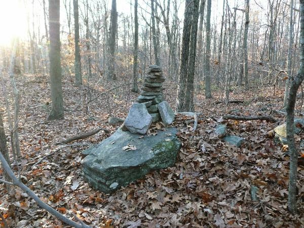
Another nice rock pile from Birch Hill

Just going back over my rock pile photos from earlier. How about the small black rock in the middle of this one?
While we are looking at it: the shim below and to the right of the black rock is kind of interesting, because it suggests a desire for the rock above it to be level with its neighbors. I should pay more attention to shims.

Other People's Pictures

Barrett Mt. (NH)  - June 29, 2008
     “A ring of rocks near a stone wall...”
Crotched Mt. (NH) - “Heading down we ran into the glacial erratics along the trail.  There are about four or so of these precariously perched rocks in one form or another:”
This image below I included because of the rhomboidal shape and placement of some of these large cobbles or small boulders was captioned:
“Which is longer: the Great Wall of China or all the stone walls in New England combined?”
Found at: Newburyport's Artichoke River Trail (MA): http://www.got-blogger.com/kimsdogwalks/
        And from a different post about South Street Woodlots Trail, West Newbury, something similar to a recent photo of Peter's, showing some large pointed (triangular?) standing stones at the end of a row of stones:

Arrowheads 2014 In Review

Last year I did a "Year in Review" post where I showed my best finds for 2013 by month. If I did that for 2014 it would be a sad sight. As I have posted before, it was not a good year for arrowheads for me and at times I really struggled to come up with anything at all. So instead of a monthly breakdown, here are my 2014 arrowheads by shape. Tip and midsection fragments and many crude artifacts are not shown. Apologies for the dirt on many of these points but I feel it helps show the flaking better when some soil remains in the flaking scars.
Triangles with incurvate bases
It was nice to find one in a material other than quartz this year. The two in the center of the bottom row are from the same spot at different times and are among my best 2014 finds.
 
Triangles with straight bases
The one at the top was my last 2014 find. Nicely made, but broken.
 Stark
The one at center was my best 2014 arrowhead find by far.
Quartz stemmed points with contracting bases and weak shoulders, one shoulder, or no shoulders
Probably a variety of different point types in this picture.
Quartz points with straight, square bases
Just a couple of fragments. These are larger and different from the stemmed points above.
Other stemmed forms
Scrapers
Here are all of my best whole arrowheads from 2014. Taking into account all of the time I spent looking, the countless hours, all of the driving and the effort and miles walked in the hot sun or in the cold rain, this is really not a lot. I wish I could say I hoped to be able to find more in 2015 but I don't. Some of my best sites have been developed or are otherwise no longer accessible and although I continue to try to identify new sites, the one new place I found in 2014 yielded very little and the other places I went for the first time were sterile. 
I mentioned back in July that I had found something special that was not an arrowhead. Here it is.

This is one half of a ground slate winged bannerstone. It is amazingly smooth and polished. It feels like a piece of plastic and I thought it was plastic when I picked it up. It is believed that these were used as counterweights on atl-atl dart thrower shafts. They are rare and even when found in undisturbed contexts they are almost always broken because soil plugs the hole and expands and contracts with the freeze-thaw cycle. Here is a top view where you can see how thin and fragile this exquisitely crafted bannerstone was, especially around the hole for the shaft. I found this on the surface of the ground in a disturbed context. This poor thing never stood a chance.
Here is a view of the hole drilled through the center. A lot of time and skill must have gone into making this piece. These are old, from Archaic times. You can see how fragile this would have been. To me, something like this seems like it would have had a ceremonial significance beyond a utilitarian item used for hunting.

I found it in the same place as this abraded red hematite paint stone.
Looking back on 2014 I would like to thank Peter for running this blog and for the inspiration and help. Thanks also to the other contributors for all their posts and information. I also wanted to add, to be clear, that I have no formal archaeological training, and my dating of point types as well as typological attributions must be regarded as guesses. I welcome any input on any of my finds, even (and especially) if it challenges my own tentative conclusions. I hope everyone has a wonderful 2015 and finds what they are searching for.

Sunday, January 04, 2015

Rocky Pond and Birch Hill - Hollis NH

I took a nice walk on Friday at the headwaters of Rocky Pond Brook - one of the brooks flowing south to the Nissitisset and then the Nashua River. 
When I parked and stepped into the woods I stepped into a small group of rock piles and I continued to see things everywhere, which I will describe. The most notable thing about this area is the many   "short stretches" of stone wall, 20-30 yards long, placed on the slopes and knolls overlooking the pond. These are shown with blue arrows above. The rock piles I found at the beginning of my walk (shown with red arrows) were more or less routine but then I kept coming across unusual stone wall features, some with quartz, some with adjacent rock piles. So by the time I hit a more significant site, up on the side of a higher ridge, my eyes were already flashing on the visual pattern of grey lichen-covered rocks, clustered with shadows between them. I already had concluded the area was a near continuous collection of disturbed stones and then I hit several acres of well formed large marker piles. Two days later my mind is still flashing pictures of clustered rocks.

In the end, I did not find much else, higher up. The action was more on the first level of lower hills around the pond. I did not explore anything north or east of the pond but it is tempting to predict more of the same types of features there. I will go have a look sometime.

Here is where I parked on Rocky Pond Road:
A bit of water, several piles, a decrepit wall leading down from an adjacent ridge.
Ducked into the woods to avoid walking across a cabin's backyard, turned a corner and oops! Here is a little wet place (left hand red arrow), not five minutes from the car; surrounded by smeared out mounds.
More details:


and
Can you see this is an outline?
These are the sorts of piles I would expect to see, in the topography where I would expect to find them, at the highest headwaters of a brook. Similar to nearby Dunklee Pond.
I was headed for the top of Birch Hill and wanted to go diagonally upwards (to the left and up on the map). On my way up I saw several interesting wall features. This was a inverted corner, snuggling a rock pile in this shape:
Here is the corner:
and the pile:


Continued diagonally over a little knoll, with a house foundation:
and another wall anomaly: a short stretch turns a corner with a bit of quartz, seems to end at a large standing stone - all overlooking the pond to the northeast:
The wall ends at the right side of the picture. To the left it continues in a less well-defined way, beyond the standing boulders. (This is the right hand of three vertical blue arrows.). 

I continued diagonally upwards, to another short stretch of wall in this shape:
It came down the hill and ended with two rock pile leading off at an angle. Perhaps related to a boulder next to the wall. At the upper end, disturbed rocks in no definite shape. Here we are looking from the lower pile towards the end of the wall and the boulder:
closer
At the upper end of the wall, looking back downhill:

Taking things a little out of chronological order. Compare this short stretch to another I found higher on the hill. It had not rock piles at its lower end, but the upper end was similar. Lower end:

There is definitely a collection of rocks at the upper end. Was it still being built?

The main rock pile site was in a saddle between two higher points along the ridge to the west of Rocky Pond. This is shown with a red outline. There were several acres of nice piles, showing up well against the pale ground cover of dead beech leaves. Here are some of the 50 pictures I took:

closer
 
(Note a pale rock, not made of quartz. I think quartz is uncommon here.)

View back to the pond:
More:
Here is bit of quartz:
closer
I think this is several marker pile sites. The ground is flat and even, though not level. Hard to get a sense of a grid but I believe it is there:

The piles seem to have had vertical sides in the past.


This one might have had something inside it:

These seemed arranged with respect to a prominent boulder:


A lovely slope. Let's say goodbye.