Tuesday, July 31, 2007

More on quartz rock piles from Georgia

Reader coferrells sent in more pictures of quartz rock piles. Saying:

The mound that may be an effigy is attached. The spine of it runs from east to west within a couple of degrees. IN the first picture you can see where one piece of granite or gneiss is missing. It is in the picture at the bottom right where it fell off. The machete case in the pic is 16" long (with the machete in it the measurement is 20"). This does not look like a farmers' rock pile.

"Odd mound due south"
"Odd mound due east""Odd mound due west"
Here are some more examplpes of quartz piles. In couple, there is a single piece of gneiss planted in the center. Again, all of the rocks in the piles is white quartz with a few chunks of quartzite. There is no quartz laying around on the ground except in the piles, and even when you dig, you do not have pieces this large anywhere on my property or even in the creek bed. Again the machete case is 16" long and with the machete it measures 20"

I just figured it out (the effigy). Draw out the rough shapes of the rocks you can see in the pic labeled odd pile due west.

The first rock is on the east side, looks like a head. The second going west is out stretched arms. The third breasts. The fourth a swollen stomach. The fifth fell out. The sixth (can be seen in odd mound due east) squatting/kneeling legs.

Weston Rock Pile site (part 2 video clips)

A couple of clips to convey the place.

In this one the piles are along a ridge leading to the highpoint. Most of these piles are visible from one platform on the side of the hill. They would not be visible from the main central platform.

A new site in Weston (part 1)

I have a new site to describe and have been busy processing the photos. Here is my description:

I saw a green spot on my topo map of Weston, showing a flat swampy area with a few hills. I somehow never noticed this place and went out today hoping to find conservation land there. Sure enough, at the end of a small road, what could have been a driveway to some of the large houses all around in that suburb, I saw a trail with the Weston trail markers:I went in and walked around. I was pessimistic about finding anything, but less than 10 minutes later I saw what I assumed was an isolated rock pile. I thought: "I won't count this unless I see some others nearby". But there was another, and another. I walked up over a little rise and ...woah! A big pile:
Now I want to tell you that there were all kinds of rock piles around this large one and it was hard for me not to imagine it as a central platform for viewing. There were smaller piles in every direction, some only a few feet from the large pile, twenty yards away, and still others breaking the horizon along the higher points in every direction. As a little bowl, this certainly made me think of calendar sites. But more specifically it reminds me of the major sites at the XXXXX in Leominster and the Moosehorn in North Salem: big piles mixed with little ones in a highly organized landscape.
Here are some of the nearby piles to the east and southeast:The last shows how the slope rises gradually in that direction. At the highpoint there, there are a few more piles.
Somewhat to my confusion there was a second large pile only twenty yards away from the first big one. This one was covered in saplings and seemed to be in less good shape:
Most of the piles visible from the first platform would also be visible from this one. In the end, I located two others for a total of four larger platform like piles, with these first two in the central depression of a hill, with another off to the west side and another off the side to the south, not visible from the others. In some cases these different platforms allowed views of the same things and in other cases of new things that could not be seen from the others. Perhaps what can be seen from where is irrelevant but this was what I was thinking about as I walked around. Here is another of the larger piles:Some of the smaller piles off to one side of the hill were only visible from here. By contrast, at the highest point of all, was the most prominent pile. It would have been visible from at least three of the platforms. Wonderful first view and then coming up to it:
Clearly a very "sentinel" pile and not at all what you expect to see in Weston.
[To be continued...]

Quartz cairn and related features from Pomfret VT

Norman Muller sent this in, following my comment that I did not know of any New England examples of all quartz rock piles.There are some.
"...a quartz cairn in Pomfret, Vermont, on a hill above the town. This hill has a number of quartz features, such as a quartz circle near the summit (see below), and a line of quartz boulders just below it. I didn't see any quartz outcrops that could explain all this quartz, although there were small quartz boulders scattered here and there on the hillside, and I'm of the opinion that it must have been brought to the site from elsewhere. On the same hillside was a quartz cairn -- or mostly quartz -- that was some 3' high and perhaps 10-12' or so in diameter (see attached). Nearby were four small sandstone standing stones that must have some relation to the cairn."

Sunday, July 29, 2007

Some of the oldest trees in Concord, MA, and a copper mine

A red oak with FFC for scale:
A white oak:
I pit in an outcrop, a known copper mine in the Spencer Brook Valley of Concord:

New Rock Pile Site - Weston, MA

Just an appetizer. I found a site covering several acres with good structure. Here is something you do not expect to see in Weston, one of Boston's most prosperous and densely developed suburbs.
Neat!

Saturday, July 28, 2007

Quartz Rock Piles from west/central Georgia

Reader coferrells send this in:
I have a lot of white quartz/quartzite rock piles on a hill side that faces east. They are anywhere from a couple feet across to several feet across and range from a foot tall to a couple feet tall. They have been there a long time. The rocks range in size from an orange to a large honeydew. There is one pile that is probably the biggest and it is probably six feet across and at least 2 ft tall. Right in the middle on top is a piece of rock (I think its granitic gneiss which is the predominant rock here). There really is not a lot of quartz around the property, just in the piles. We find a LOT of quartz and quartzite projectile points in the pasture below. Do you think they might be Indian graves. I really do not want them bothered if they are. People have asked me what the rock piles are and I usually tell the they are farmers' rock piles. Then they always ask where the farmers got all that quartz... These piles are in west/central Georgia.

In pic 506, you can see multiple mounds going up the hill.
Incidentally the points we find here are from the Archaic Indians, very old. These mounds appear to be very old.

Pic 508 is one of the piles that has a single piece of granite in the middle.
Pic 507 has a camera case that is 6"long and 4" wide for comparison to the rocks.
And 511 is a pile. These are not all of them, just a few. There are a couple that have been tumbled.But yes, my conetention has always been they were probably prehistoric and that no farmer would pile only white quartz...on the TOP of a ridge.

One other thing. These piles are on an east facing ridge overlooking a valley with a creek at the bottom. It is a nice view.

[Note from pwax] With the exception of some small assemblages of quartz which could be called a "pile", I haven't seen anything like these pure quartz piles up here in the northeast. If anyone else knows of some, please leave a comment. As I recall, there is an Eagle Mound, also in Georgia ,made or at least surfaced with quartz - leading me to wonder if this use of quartz isn't a particular and identifiable tradition from that area.

Thursday, July 26, 2007

Short Stretch of Stone Wall - Willard Brook State Forest Lunenburg

Spent a morning walking around in the dry woods over there and I kept thinking I was seeing short stretches of stone wall, only to realize that I was looking at one end of a wall that continued off into the distance. But then eventually I did find this one short stretch. It starts near the camera, goes 20 yards downhill to the west and ends (just behind the pine sapling in the picture).

Light to no posting

I have to go take care of family business for a couple of evenings and have little to post about anyway. Next week I am going away for two weeks, so I do not expect to be posting much.

Wednesday, July 25, 2007

A small rock pile site in Carlisle MA

FFC took me over to visit a friend who has access to a small piece of Carlisle Conservation Fund land behind his property. We joined up with the friend and took a walk, out over the field and past the stone wall into a low semi-swampy area that was more or less surrounded by the curve of a ditch-like water course. At the middle of the curve there was one large rock pile, of indistinct shape. Nearby there were a few low piles. Some were on the ground and some on supports. The whole area was perhaps one or two acres.

Here are some of the smaller piles:
Here is a view of the large pile from one side:
And here is a view of the extent of it, with friends on top for scale:
The property owner said that he played in this area as a child. Also, there was part of an old road through there and going right next to the large pile.

Rock Pile in Path

Continuing to make my job easy, Keith from Mendon sends in:

I have walked over this many times, then it hit me like a ton-of-bricks! It's a rock pile! there are many similar low piles nearby also. This begs the question, what came first?

Note: Piles in the path are easy to miss but are sometimes a good clue to other rock piles nearby - PWAX

Tuesday, July 24, 2007

Rock pile mangled by power line crews

From Keith in Mendon.

From The History of the Town of Derby

James Gage writes in:

From:
The History of the Town of Derby, Connecticut, 1642-1880, with Biographies and Genealogies, by Samuel Orcutt, 1880, Springfield, MA: Press of Springfield Printing Company, pp.xliii-xliv

“Mr. Barber’s account of Chuse and the Indians at the Falls is interesting and worthy of preservation, and it is as follows:

“For a long period after the settlement of this place, it was called Chusetown, so named for Chuse, the last sachem of the Derby Indians, who is said to have derived his name from his manner of pronouncing the word “choose.” His proper name was Joe Mau-we-hu; he was the son of Gideon Mauwehu, a Pequot Indian, who was the king or sachem of the Scatacook tribe in Kent. It appears that Gideon, previous to his collecting the Indians at Kent, lived in the vicinity of Derby, and wishing to have his son brought up among the white people, sent Joe to Mr. Agar Tomlinson of Derby, with whom he lived during his minority. Chuse preferring to live at Derby, his father gave him a tract of land at the Falls, called the Indian Field. Here he erected his wigwam, about six or eight rods north of where the cotton factory now [1836] stands, on the south border of the flat. It was beautifully situated among the white-oak trees, and faced the south. He married an Indian woman of the East Haven tribe. At the time Chuse removed here there were but one or two white families in the place, who had settled on Indian Hill, the hight of land east of the river and south-east of the cotton factory, in the vicinity of the Methodist and Congregational churches. These settlers wishing Chuse for a neighbor, persuaded him to remove to the place where the house of the late Mrs. Phebe Stiles now stands, a few rods north of the Congregational church. When Mr. Whitmore built on the spot, chuse removed back to the Falls, where a considerable number of Indians collected and built their wigwams in a row, a few rods east of the factory on the top of the bank extending to Indian hill. Near the river in the Indian field, was a large Indian burying-ground; each grave was covered with heaps of stones. Mr. Stiles, of this place, purchased this field about forty-six years since of the Indian proprietors, and in ploughing it over destroyed these relics of antiquity.”

NOTE: Orcutt’s source is John Warner Barber’s Connecticut Historical Collections, 1838, pp. 199-200.

Quartz arrowheads from Mendon

From reader Keith:
Here's a few arrowheads I have found over the last few months in Mendon. The one on the far right I found yesterday! the one on the far left I found in my garden while I was watering my tomato plants. (It is missing the tip portion) The other two were kicked up by ATV's.

Monday, July 23, 2007

Wedged Rock - Stiles Hill Boylston MA

More Nipsachuk news - from Tim M.

Reader Tim M. sends in this link about the Judge ruling in favor of the developer but the Indian "burial ground" is still an issue. [Click here]

Thursday, July 19, 2007

Pile on split rock from Carlisle

It does look a bit like a turtle.

Assumed to be recent

This was along a tractor path of a semi-active farm not more than 70 yards from some more legitimate rock piles. Probably not anything but pretty anyway:

Wednesday, July 18, 2007

The American Chestnut

They're baaaaaaaack!

Other stone structure - Stiles Hill Boylston, MA

I wrote about the site below the radio tower on the west slope of Stiles Hill. That site was somewhat in doubt as a ceremonial site. Later, around to the south and east I came across some piles and structures that seemed more legitimately "impractical".Especially this:But this also looks quite delicate and recent - the kind of thing that contributed to the confusion about the earlier site. I think it is reasonable to conclude that, pretty recently, someone was performing ceremonial acts here. Possibly they were taking advantage of an earlier site, possibly they were taking advantage of some earlier practical rock disposal. The evidence is in-substantial.

Tuesday, July 17, 2007

Bayers Lake Mystery Walls, Halifax ,Nova Scotia Canada

Reader Michael E. writes in:

These walls have been a mystery since their founding some 17 plus yrs ago. Since there has been no postings of the Bayers Lake Mystery walls in the Rock Piles site. I think its time that it was brought to light. It’s part of

NEARA Special Event in Nova Scotia

August 8 - 13, 2007

.

Hosted by NEARA's Nova Scotia Chapter

Six days of Field Trips and Adventures in Nova Scotia!

Featuring: Oak Island, the Yarmouth "Runic" Stone, the Bayers Lake Walls, the Chain Lake Ruins, and the Bedford Petroglyphs

These walls were mentioned in a book by William S. Crooker, an
unpublished archaeology report by Stephen A. Davis (on file at the
Nova Scotia museum), and a Halifax Herald article by Parker Robinson
on November 10, 1990.

Chronicle-Herald Saturday, November 10, 1990

Halifax-area ruins stump archeologist
by Parker Robinson

Mysterious old rock walls and foundations uncovered near Halifax
have temporarily stumped a local archeologist and museum curator
who are unable to explain the origin of the structures.

Saint Mary's University archaeologist Stephen Davis visited the
ruins last Tuesday with Nova Scotia Museum official Bob Ogilvie
and the man who reported the finding, Bedford resident Jack MacNab.

The winding, metre-tall walls and basement foundations have left
Dr. Davis scratching his head as to who built the wall - which extends
up to 500 metres - why it was made, how and when. He says the ruins
could date back to the founding of Halifax.

"It's quite a mystery," Dr. Davis said Friday. "It just doesn't make
sense, it's not industrial yet it doesn't appear to have been used for
long term domestic stuff. I have no real idea what it is."

The location of the site will not be revealed until archeologists and
museum staff have conducted a more thorough investigation of the area.

Mr. Ogilvie, curator of special places, is investigating who owns the
thickly vegatated land the ruins lie on. If the land is slated for
imminent development, an attempt may be made to halt such proceedings
until a thorough evaluation is done of the area.

Dr. Davis says the construction style of the walls is Celtic, likely
built by someone of Scottish or Irish descent.

"It's a massive structure, the wall is incredible," said Dr. Davis.
"It's very well made. And other curious things are a couple of gates -
one of them is directly in front of a steep slope."

Mr. MacNab came upon the ruins in late October after being tipped off
to its existence by a local aerial survey company.

"I went to the area they said they were in," said Mr. MacNab, who
contacted The Chronicle-Herald after he found the ruins. " I couldn't
find them and was on my way back when I practically walked right into
a foundation.

Mr. Ogilvie said he expects to know whether development will be taking
place in the area of the ruins by next week.


http://museum.gov.ns.ca/places/special/palintro.htm

http://www.neara.org/MiscReports/03-21-05.htm

http://www.neara.org/events.htm

http://www.vortexmaps.com/novascotia/page15.html

http://www.gov.ns.ca/dtc/heritage/heritage_specialplaces.asp

The site is a Protected Area which does indicate that the
Museum takes it seriously as a possible antiquity rather than just
some old farm walls of no importance.
People seem to be respecting that and not digging for treasure there
or vandalizing the walls.
This might be a good forum to compile what information we do know
about these structures and try out some various hypothesis against the
facts.
When I sort through the possible uses for these structures none of
them seem to make a lot of sense.

Agricultural... Poor farmland on rocky forested hill. Possibly some
agricultural potential in the small floodplain near the rail crossing.

Livestock Pen ... Why build good stone wall to put sheep in at night
when a simple wood and brush structure would do? The walls seem to
just peter out at the southen end allowing any predators easy access.

Defensive... Poor defense strategy to build a defensible wall that has
easy access to a hill that overlooks it.
Playfort for training soldiers? Doesn't have to make military sense then.

Industrial.... ??? Could 5 sided structure be gunpowder storage with
good drainage and a low roof?

Ceremonial ?? Is this some early church or site of worship?
At least it doesn't have to be very logical for religious use.


Why the nicely formed gate? why enter there?

Why is the 5 sided structure 5 sided? First thing I thought was
it would be a good shape for a witches house but it is not a regular
pentagram beloved of the occultists.

The 5 sided structure had apparently low chest high stone walls. What
was roof made of?

What is the structure within the 5 sided structure? Haerth seems
plausible but there doesn't seem to be sufficient stone nearby to
re-construct a chimney out of.

Why build the 5 sided structure on sloping bedrock? why not find a
flatter place or more traditional stone supports on soil? Drainage
might be a possible answer.

What is the relationship of the small cottage-like foundation to the 5
sided structure. Granite steps lead up the hill to ?

The site itself has not much special about it to recommend it as
either a discrete hideout or a watch place for harbour traffic. Many
better spots for either could be found within a few km.

Is this the complete site as we now know it or is it only a piece of a
once larger complex parts of which are now destroyed or yet to be found.

I'm glad to see member Kris and friends are doing a good job searching
further afield for additional clues. The idea of a good stepladder
shot sounds useful. The triangles found by Kris's friend do seem to be
natural formations to me. I can locate some other similar triangle
holes in the slates and whins of the Halifax formation at several
places near the harbour. That type of rock seems to fracture like that
even if cross bedding is not involved.

The only additional evidences I have found are the locations where it
appears some of the wall stones were quarried, or at least broken off
the hillside. I assume others have found these too. North of the 5
sided structure and off the side of the access road is where they can
be found.
No sign of drill holes or tool marks visible to me.

These are the questions that in my mind still make these structures
Mystery walls.

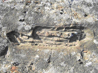
Interesting hollowed out formation in the bedrock at the Bayers Lake Walls site.

Stairway to open bedrock ,foundation below.Stairway to open bedrock, north of the wall.150 metre Rock wallRock wall collapsing over time.More of the rock wall.More of the wall
The 5 sided wall structure.

Inside the 5 sided wall structure.