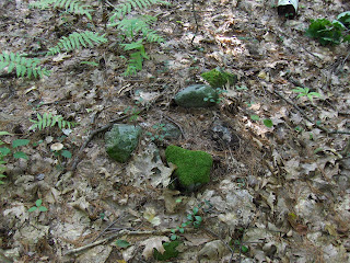
 Another view:
 Closeup:
This is about rock piles and stone mound sites in New England. A balance is needed between keeping them secret and making them public. Also arrowheads, stone tools and other surface archaeology.
 Another view:
 Closeup:
 It is a familiar shape.
Medicine Wheel Intensive at Earthlands
October 14-16, 2011
Register by 9/9/11 and save $75!
"My use of the Medicine Wheel has kept me mindful of my highest personal aspirations" - JM
************************************************************* Let me write about the two sites outlined in red next to the yellow trail - locations are only approximate. The smaller site, a few feet from the trail junction, is visible from the trail. A first pile was just a small arrangement of rocks next to the beginning of a brook:
 A few feet downhill, also next to the brook, was a little table built against a rock:
 It is easy to imagine this as a small altar next to the brook.
 Another, from one side:
 From the other:
 This one seems to have a niche in it as well. So while we are on the subject of "altars" next to the brook, perhaps these have a similar intent. I saw three other of these large piles with large rocks, in the ferns, a few feet away up the brook. These were in the video here. Blurry photos here:
  and here:
 By this time I was soaked, so I did not get good closeups, or think to wonder if these also had niches. But on the way back out I saw another table like structure:
 During the walk I was thinking about the classification of most sites as mound-with-hollow sites, marker pile sites, or water-related sites. Here are what seem to be water-related piles and they might have a feature involving a table or a niche. Something to look for.


 The piles are in the more level area below this slope. At first glance, one sees something gray poking out of the surrounding bushes:
 Many are rectangular, about 8 feet across, and pretty smeared out.
 Another:
 This last one has a couple of larger rocks placed outward from one corner of the rectangle. Doesn't look random. This pile and others had some white quartz/feldspar:
 How unexpected to find these in Concord:

 A bit closer to the brook were some other piles, a little more typical of brooksides around here.
 Even managed to find one larger pile built on support. Always happy to spot "big game" like this.
 There was a mixture of styles at this spot. Is this next an effigy, or a pile with a "manitou" stone?
 At first I thought it was smeared rectangles and smaller piles on support. Then I saw that the piles continued into a lower wetter part of the site. Then I also saw some larger piles built on boulders, and evenly spaced - if not in lines:
 Although not so obviously placed in lines and evenly spaced, these had a bit of a feel of an early marker pile site. I felt these piles were akin to the larger chambered mounds at B. For example this pile, the largest I saw at this site, is reminiscent of the piles with hollows built against boulders that we saw in Dunstable (see here).
 So, an interesting and diverse site, joining a short list of other sites in Concord, a short list of sites in Estabrook Woods.
 None of these sites is fragile and, if they include burials, then the physical remnants have long since dissolved back into the soil. So there is a map. I won't discuss A (which I blogged here) or the un-labeled site at lower right. The site at B was shown to me on a field trip I took long ago with Norman Muller and Steve Ells. The site at C, at the headwaters of Dakins Brook, is new. It is rare to find a new site in my hometown and this is an interesting one.
 You can see the hollow on the interior of the pile, and get some sense of the vertical height of the remaining walls.
 From the other end:
 Here is a video, trying to convey the shape:
 These are slightly smaller than the examples from Fitchburg (see here and more generally here) but it is not too much of a stretch to see these are all part of a common culture. So the Wachusett Tradition is seen here in Concord too.
 I could not make out much of the internal structure.
  These larger, longer mounds, are often seen at "Wachusett" sites. Following the archeology convention of wild guesses based on minimal data, let's just say that this hints at a hierarchical society, with special burials (the mounds higher on the hill) reserved for some individuals and a larger communal grave (at the foot of the hill) for others.
 Even though one picture is probably enough, I found a second a few feet from this first one,
 Since it is not clear, you'll have to take my word for it that these are rectangular piles perhaps 10 feet across. I also found three smaller piles built on support boulder (including one with a quartz cobble - not shown).
 It was near a breakout zone, next to an end of a short stretch of stone wall.
 and:
and: and this one, that leads down to the site with the rock piles mentioned above, before tapering off in a swamp:
 Another short stretch:

 That is as close to the Wachusett Tradition as I am likely to get up here in Tyngsborough.