Thursday, September 28, 2017

On the way to the top of the Mulpus

As mentioned recently, I made it to the top of the Mulpus. I went in from the west, parking on New Townsend Rd and cutting into the woods. I hit a trail along the side of the hill, followed it south to where I could see the back of a house, then uphill to about where I marked on the map:
Here there was a faint gully with a rock pile greedily taking up the whole space. Some views:
 A few auxiliary smaller piles confirm this is some kind of site.
 This is right next to the trail:

When I got home I tried to mark the spot on my "official" topo maps but it seemed there was already a spot there. But I don't believe it, this was a new place for me.

Tuesday, September 26, 2017

Top of the Mulpus

It is a fine brook going from its start in Willard Brook State Park in Lunenburg, down through Shirley and into the Nashua River in Ayer. I finally got to the high point: a little pond, the valley continued above this little pond but it was dry.

Friday, September 22, 2017

West of Caswell Rd - Fitchburg

I think this hill is called Dean Hill, based on the cemetery signs. This place is a bit featureless but similar enough to other nearby topographies to suggest exploring. There are a couple of brooks on the flat western side of the road I wanted to see and I wanted to walk south to north to get to the top of Laws Brook. I navigated successfully under an overcast sky seeing just one mound at the top of a faint ravine that may be where I marked on the map. I was doing some zig-zaging
So I am walking along and see this:
I did not get good pictures as the light was poor. But here we have it:
The usual thing, as I was writing a couple posts back.
There were one or two smaller piles to the side, across the ravine. Here we are looking back from there:

Overall this site layout reminds me of the layout at the big mound we saw last weekend in Princeton. Namely a larger rectangular mound on one side of a low place and smaller mounds across the way.

A view of the cemetery near where I parked: The Dean Hill Cemetery

Thursday, September 21, 2017

Archaeology Walk at Cedar Swamp

(Via Peter Anick of NEARA)

Sunday, October 1

1:30 - 3:30 PM
RAIN DATE: Oct. 8
Learn about Westborough before the arrival of Europeans in this fascinating exploration of pre-history. Cedar Swamp was used by Native Americans for thousands of years due to its unique location at a crossroads of waterways and trails leading from Canada to all over New England and beyond.

Walk leader Michelle Gross, with degrees in Archaeology and Anthropology, has worked on digs in Cedar Swamp and many other locations in Westborough. We will find out how the evidence uncovered has given us a wonderful picture of Native American life.

Meet at 57 Flanders Rd (where a stature of a lady holds the mailbox). Follow the driveway about 1/2 mile back and take the left fork to a parking area.

Wednesday, September 20, 2017

Mounds in general

They are all over the place. Looking back over past blog posts, I show hundreds and hundreds of the same thing - rectangular, slightly pyramidal, with a depression or "hollow", near the middle. Often with side structure forming a curved around "tail" as an alternative or companion to the "hollow". They vary in size, they vary in height, they vary in decrepitude. But surely it is not my imagination. Why doesn't anyone else report these things?

Also, you know darn well those are burial mounds. Let's not talk about it too much! A truly unique resource, perhaps mostly in New England but we have seen photos from Georgia to New Brunswick showing the same thing. It is incomprehensible to me why these burial mounds are not well know to the archeological community. Get out much? The mounds are all over the place.

Adding:
If you go back and watch the video of the large mound we just saw in Princeton, there is a moment just after I 'fall in', where some terracing appears - almost like little amphitheater seats. This is the side structure I am talking about above. It is like a "tail" on a grander scale. A screen grab:

Huge mound - Paradise Pond Princeton

If you go into Leominster State Forest from the west on Rocky Pond Rd., Paradise Pond lies to the south on your right. Soon a dirt road appears to your right, called "King Tut Highway" and you can hang a right and head down along the west side of the pond, east of Wolfden Hill. It is my impression from the past that there are small sites all along that western side of the pond - a grassy under-story beneath the trees. This was the place where I did my first "experiments" finding rock piles, before hand by looking at a map, then confirming by going there. I mention it here. I remember driving out with my wife for the first experiment but cannot find the pictures I took - maybe in the "journal" I kept before blogging. Anyway...

Went to show the place to the Ladies from Harvard and we stayed right of the road at the edge of the drop off to the wetland. Here is a huge mound right in there:
SB in the foreground and GC in the background. GC is standing at the top of a ramp. Ignoring additional terracing and structure that you can glimpse in the video (previous post), the side and top views are something like this:

Here is the view from across the way:
Quite a big mound.

And a smaller pile underfoot (when I was taking the above photo):
The small one is very convincing. The first one was a bit of a mess and it almost seemed like a sand pit with this mound comprising its discards. But seeing the second smaller mound eliminates such doubts.

Monday, September 18, 2017

Paradise Pond - Princeton

Lots of stuff on the eastern side. This was not far from "King Tut" Highway, closer to the lowlands.

Friday, September 15, 2017

More west of Lovell Reservoir Fitchburg

A bit south of the first mound group I discussed here and through more than a little bit of raspberry, I came out into clearer spaces with more rock piles. Damaged.
And more particularly:
I was quite taken with the next one, and have panoramas from various angles:
It is a complicated structure - a genuine ruin.
Finally, some are more smeared out than others. It would be interesting to know why.
Quite a busy place, that otherwise inconspicuous bit of map.

Celebrate Hopkinton's "Ceremonial Stone Landscape" on Oct 7

(via the R. Ferrara and Friends of Pine Hawk)

Please join Hopkinton Rhode Island in celebrating the dedication of its Ceremonial Stone Landscape on October 7th. Many of you will remember the team from Hopkinton presenting on this work at our meetings, and their process is a ground-breaking one for future collaborations among us. Congrats Hopkinton!

Thursday, September 14, 2017

West of Lovell Reservoir Fitchburg

The whole shoulder there, looking out east over the open space of the reservoir is worth the walk. I re-visted an old mound group and found another. Maybe around the 'L' of Lovell or near the end of that dashed line on the map. To find the re-visited site, get up to the edge of the steep part of the ridge and follow the stone wall north until you get to this pile:
(sorry about the light). This is a bulge in the wall but it has a distinct depression in the center and a couple pieces of quartz next to each other. I remember there was a pile up hill a few steps and the last time, when I went to look at that pile there was another larger mound visible in the bushes forty feet or so away. I could not see it now and would never have gone to look for it. Even knowing they were there it took me a while to locate the three mounds I remember.
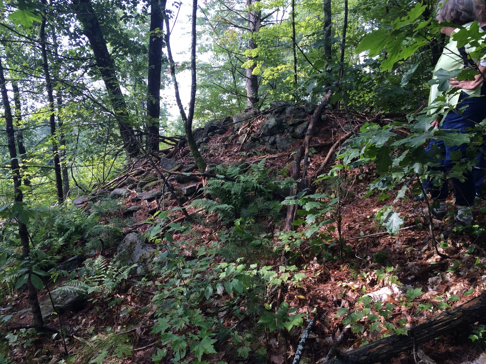
Biggest:


Another, really covered in bushes:

 Nice piece of creamy quartzite.

Then finally the smallest, which is the one I remembered seeing first, in the past:

A wonderful little mound.

I don't need to try too hard to classify this mound group. Is is part of the continuum of such mounds along Falulah Brook from the Hospital to Ashby Rd West. [And it is nice to know there are still plenty of backyards along there that I have not had a chance to sneak into yet.]
***
I walked north to the feeder brook, then back south, through the first site and on southward toward my car. A short stretch of wall in there:
I remembered one little curious bit of stone wall corner and puddle, not too far from the first group. And I did see it on the way north. But heading back south I came to some others. Wait a minute! What is this?

And where was this?Another wall bulge with a hollow:

We still haven't gotten to the second mound group. I'll post about it separately.

Field find

This picture (barely) shows two large male turkeys engaged in some kind of combat. I watched them circle each other and then briefly attack each other for several minutes. I had never seen such a thing. You will notice, on the right side of the picture, some areas where the grass is thin. It is very sandy in this place.
 I spotted something in one of the sandy patches where the grass grows sparse.
A nice one. Stark, I believe. Material is a bit unusual. More layered than the argillite tools I find. Slate, maybe. I found this back in May. I have had some other lucky days since my last post, but don't often have time to sit down at a computer. I will post some other finds soon.


Tuesday, September 12, 2017

Alpine Hill Fitchburg, with more bad cellphone pictures

I went out with the ladies from Harvard ("LFH"?) but few photos are worth passing along.
A new big thing I had not seen:
And, for example:
On the southern shoulder (where they saw a nice rocking stone, I only heard it from below, while photo'ing this):
and a few more mounds from the main hill. Found one rock pile near the top that incorporated a rusted wheel rim from a wagon.

I was unable to locate the large mounds I blogged about in the past at Alpine Hill - just as I am pretty unable to locate the previous posts but, for example: http://rockpiles.blogspot.com/search?q=Alpine+Hill

Free Webinar on Indigenous Stone Landscapes

From Curt Hoffman:
[link fixed] Register Now: Free Webinar on Indigenous Stone Landscapes on Sept 19.

Monday, September 04, 2017

Long Hill, Bolton

Driving up Long Hill Rd from the north, I saw a watercourse on my left and thought it looked worth exploring. When I turned onto Annie Moore Rd, I found the watercourse had curved around and began there next to #23. I thought: here is where I should look, and in fact this was next to the road:
You also see something smaller in the woods behind it but, next to a house, I did not go take a closer look:
That would be about here: