Rock climbers like these rock faces - the Flatirons - in Boulder CO.


Rock climbers like these rock faces - the Flatirons - in Boulder CO.
Went to look for arrowheads up in the mountains in a "gentle valley" in the mountains not far from Boulder CO. On the way there, along Lee Hill Rd, there was a rock pile site at the high point. Private land prevented a good look. Here is what I could see:


Then we went by dirt road (lost the County Rd numbers) to Gold Lake. On the way back I noticed this next to the road:

Before visiting Boulder I picked some places that looked worth exploring for arrowheads. One was the Pawnee Grasslands, just to see what was out there (see here); one was Rabbit Mountain (see here) because there were springs and the hope of finding game trails. On the third day, with my wife, son, and son's girlfriend, we explored what I hoped was a gentle valley within the Rocky Mountain National Park. I was hoping for an upland environment that was not strenuous for hiking, looked around the topo map and picked Gold Lake.
Gold Lake, east of Ward CO, is a private campground. Later I decided that $210 for a night and three meals, would have been cheaper than staying at a hotel. Anyway, we ran into a guard who warned us off, and told us a few things about the area. I mentioned we were looking for arrowheads [you never know what you might learn] and he said this place, Gold Lake, was where the Arapahoe Chief Niwot spent summers. So my choice was a good one. All of the lake, and especially the northern shore, are private and closed. It turned out that south of the lake was national park with "unrestricted camping". So we drove over there and spent a couple hours poking around and trespassing, by sneaking in to look at the lakeshore, from a spot that could not be seen from the north. An artificial lake, they had drained it a bit:
Fire rings:


I think this is not quartz but not sure. Two pieces of worked edge, lying next to each other on the sand, seemed to fit together like a "plausible blade reconstruction". I doubt this is plausible, but you can get a sense of what an arrowhead might have looked like:

Another one of the types of places in CO that seemed worth exploring for arrowheads were a few spots marked "spring" on my topo map. I picked the furthest east foothill of the Rockies I could find. I figured that, in an arid environment, a spring would be a likely place to find signs of man. Sadly most of the "nature" around Boulder is fenced off to protect it from a bike-crazed culture.
[A brief digression for social commentary: Boulder area is overrun with physical fitness enthusiasts. For them, nature is an extension of the gym - a place for vigorous exercise. Sadly they have no idea what to do outdoors. The rivers did not even have boat launches! It makes me contemplate trying some kind of outreach, to teach them about identifying flowers, birdwatching, archeology hunting, butterflies and moths.....the list goes on. One senses that a large number of New Yorkers relocated to this area, for the rock climbing and the overall hipness of the place. On the other hand, it has the least expensive and most excellent food I have had, anywhere in America.]
Driving up to the Ron Stewart Preserve, I started to notice stone walls:

The first spring we went to on Rabbit Mountain was public land, fenced off from the public. We got lucky and found some un-fenced public trails on the western side of Rabbit Mountain.
Everywhere, there were suggestive bits of wall, propped rocks, and outlines on the ground. Was it purely ceremonial? I doubt it. This is the traditional homeland of the Arapahoe, who where a [displaced eastern?] Algonquian speaking tribe. One imagines them sharing some stone placing traditions with the New England tribes. But we were looking for arrowheads and thinking about hunters. All the walls I got to look at carefully were designed as funnels running up the sides of slopes.
We walked up the path a bit:
We left the path at an outlook, heading down over slippery rocks to get a better look at a wall. It was rainy so what is apparently a very rattlesnake-y place was safe to scramble around. There was a big wall cutting across the slope:


Here is the pine tree, the gap is below it.


When else was I going to get anything like a genuine "Great Plains" experience?. Planning to visit my son in Boulder I spent weeks pouring over maps and aerial photos trying to decide where we should go look for arrowheads.
Found the perfect spot: next to a major creek (Howard Creek), on public land (Pawnee Grasslands National Park), and signs of past plowing - with long straight lines from industrial scale plowing overlaid on curved lines from manual plowing. So the ground will have been churned. I zoomed in on a destination (up CR77 from Briggsdale, between CR96 and CR100 - figured we could pretend to be bird watching, if deception was called for) and, to my delight, spotted a marking on the map: "Arrowhead Windmill". Seemed just right.

Drove out that way (~100 miles from Boulder), getting to chat with my son, we finally arrived and stepped out. The ground was covered with chips:
.JPG)
Top to bottom: a scraper made of jasper (metamorphosed chert); a chalcedony working edge; a bit of a 'hatchet' made of chert [??].


According to the Denver Museum of Nature and Science, this is a piece of rock crystal. I have a hard time believing it. Maybe it is SiO2 crystal but forged, not natural.

Both Mr. Merriam and Mr. Webster agree that Pareidolia (per-ˌī-ˈdō-lē-ə -ˈdōl-yə) is: "The tendency to perceive a specific, often meaningful image in a random or ambiguous visual pattern. The scientific explanation for some people is pareidolia, or the human ability to see shapes or make pictures out of randomness."
But what do you call perceiving meaningful intentional repeated visual patterns????

A triangular flat topped boulder,
Chosen perhaps because of the suggestion of an eye,
In just the right place, in order to appear as a Big Stone Snake???
A diamond shaped stone, seven scales back,
Can sometimes be another repeated pattern,
Another important stone, perhaps fallen, whispers:
"Possibly the Crystal," but one just can't say for sure...
Consider this slope, which I believe has several deliberate stone lines, forcing game to climb the slope along specific routes.

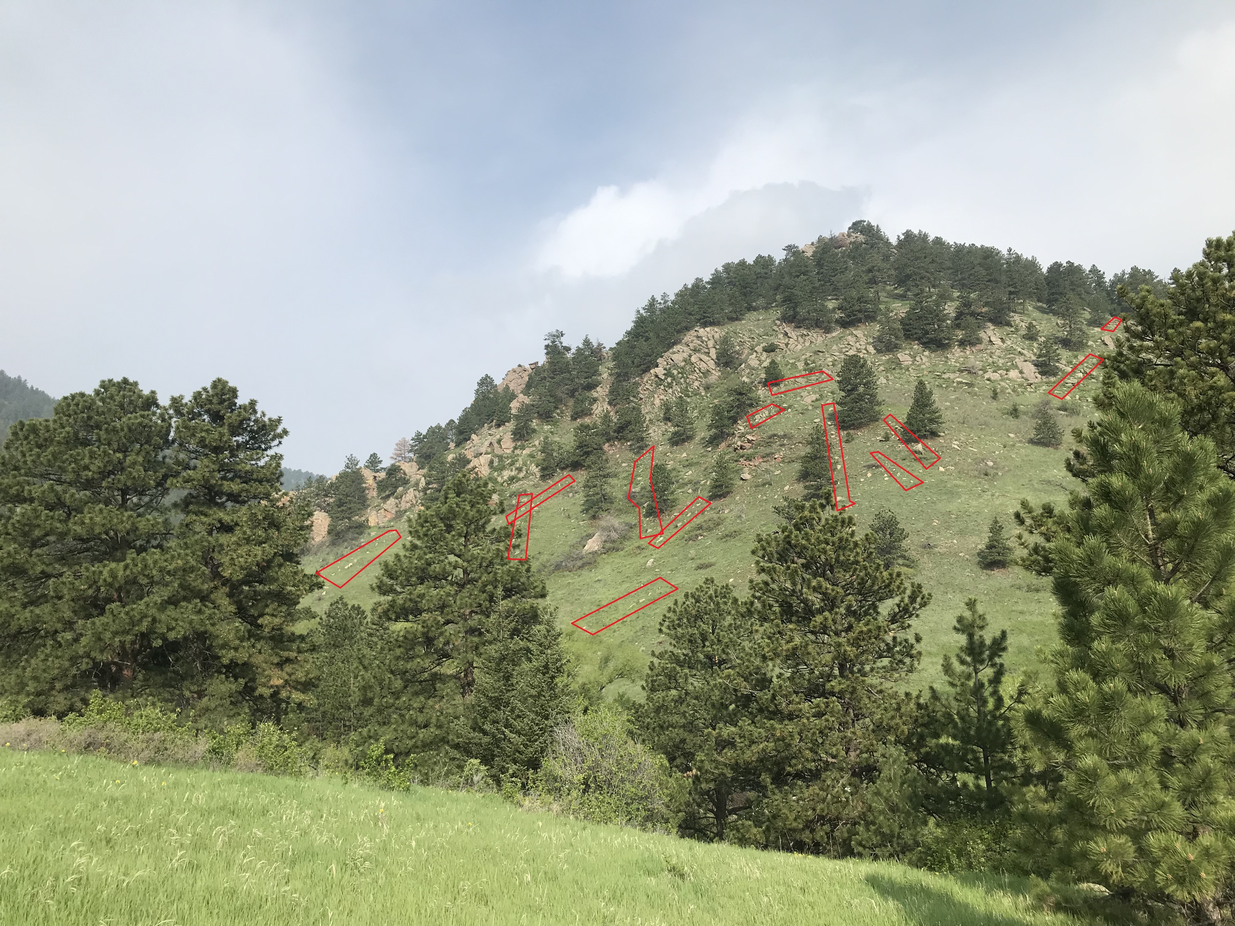
Noticing out-of-place rocks and non-random rock arrangements are visual skills that are helpful for looking for rock piles here in the East. When I go hiking out West, these skills automatically kick in and I notice things that, in the end, seem closely related to animal "flow control" and hunting. It is easy to infer a practical significance to the western structures and this makes me wonder if some of our eastern ones might have a practical function we are not aware of. In any case, skills for finding rock piles are related to skills for finding arrowheads - or at least for finding hunting sites.
Let me give a few examples. In Nevada I explored a hill looking for arrowheads, found barely visible rock piles, and learned something interesting about how hunting worked at this site. In the Boulder area of Colorado, I noticed many subtle stone walls arranged on hillsides - making funnels, blocking off spaces, and covering the entire slope in such a way that they might work differently in different wind conditions. I see on YouTube that animal "funnels" are a good place to find arrowheads but it is hard for me to get to the top of a steep slope (just like the poor animals that went that way) and, in eastern Colorado, there is enough topsoil that you would have to excavate to find arrowheads - or get lucky with the erosion.
I have written a bit about Nevada here and here is a link to one of the sites from Colorado. If you are impatient, take a very close look at this slope just north of the "Flatirons".
This might be of interest. For instance: discussion of serpents and of cliffs with faces.
Mi'kmaw Story Sites and Geology of Nova Scotia with Gerald Gloade - YouTube
Slim pickings from cornfields along Rt 495.
This one, is a "Levanna" triangle.


Chris P. describes finding a complete one here. It is a unique shape.
Here is a quartz triangle. Hard to find one that is un-damaged.


Register HERE. Acton Memorial Library: Thursday, May 11, 7:00-8:30 pm
Author Dan Boudillion will discuss his just-published book on the history of the Nashobah Praying Indians from the 1654 establishment of Praying Indian Plantation to their sufferings during King Philip’s War and exile on Deer Island, then to the loss of their lands in 1736. The Nashobah village was one of the 16 “Praying Villages” established in Massachusetts in colonial times and included essentially all of modern Littleton. However, part of Acton was, and still is, on Nashobah Praying Plantation land! Dan will share how the book came to be, and fascinating stories of the Nashobah Praying Indians who are still alive and a presence more than 350 years later. Books will be available for purchase and signing at this event, as well as on amazon.com.. In-person only.
[Not rock pile related] This is pretty funny:
Primitive Bushcraft - How to Find and Use Quartz | Self Reliance - YouTube
He approaches a small boulder of quartz, sitting out-of-place on the forest surface. He examines bits of debitage and discusses the properties of quartz. It is out-of-place too. Evidence of both ceremonialism and practical life.
You could say the guy is living in the present. But with "bushcraft" in the title, I thought he was at least going to make sparks.


