I don't know if some of my friends would agree with me but I think that too much emphasis on alignments is a dead end. Why? Because alignments are part of a combination of factors which draw on sky, earth, and underworld. But it is a mistake to study or focus on just one aspect - alignments - without studying and trying to understand the rest of the complex context of factors.
Did you know, having read Manitou by Mavor and Dix, that they spend a significant portion of the book writing about rock piles? You probably forgot because that part of their book does not make an impression. Actually Jim spent a lot of time studying rock pile sites in the Falmouth area and writing about it. However the significance of rock piles does not come through in the book because [I claim] the book is focused on alignments and that misses a lot of what rock piles are about [namely the earth and the underworld, by my interpretation].
So what else should people look at, if not alignments?I do not wish to be too didactic but I am interested in topography, shape, materials, and statistics from many sites.
Tuesday, January 31, 2006
More nice photos from Norman Muller
Hat tip to Norman, these are beautiful piles . He says:
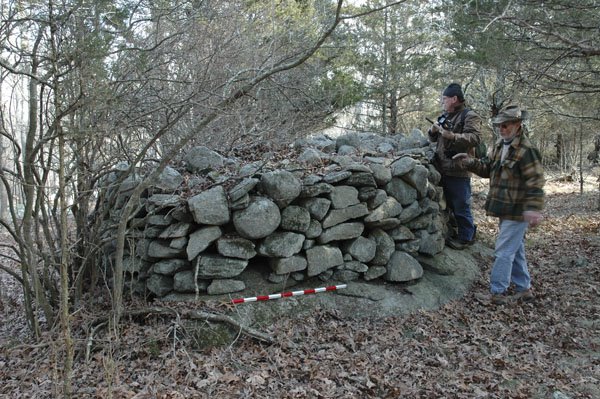
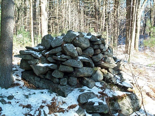
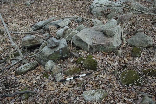
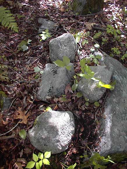
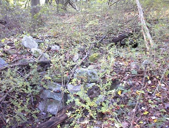
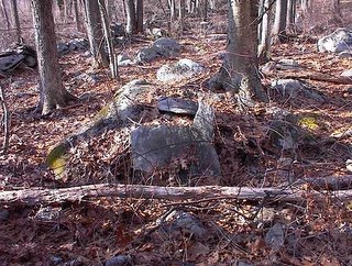
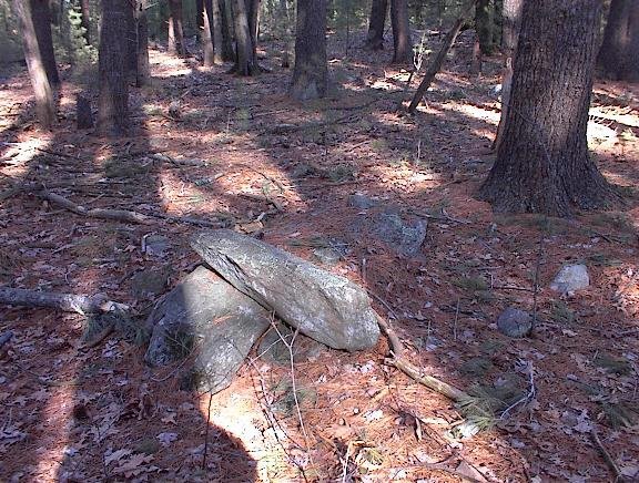
Last weekend, at a site in western RI, near the CT line, I was shown a magnificent platform cairn constructed on a flat ledge outcrop. It measured 5m long and 1.2m high, and was roughly oval to circular in shape.
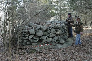 Nearby were cairns on boulders, some fairly carefully constructed, and a possible turtle effigy. In the image shown of the latter, the head is near the bottom, pointing left. Also near the effigy was a boulder with two holes drilled in it. I have seen drilled holes in boulders in Rochester, VT, that make no practical sense, as they are in locations that would be of no help in lifting them.
Turtle Piles v.1
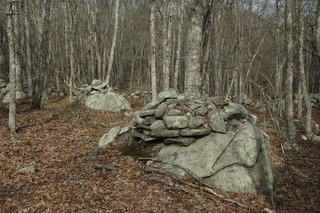
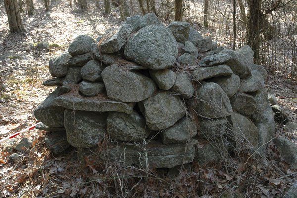
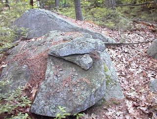
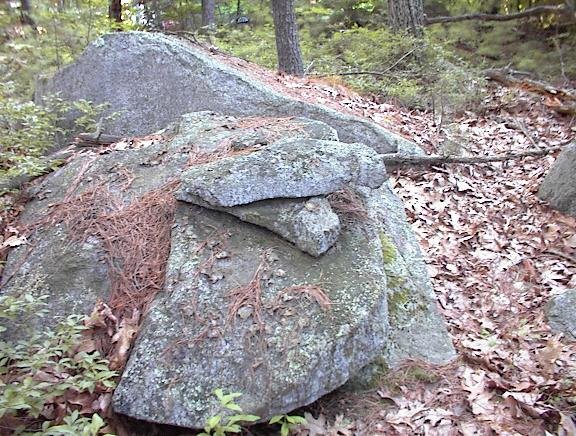
Several years ago Tom Paul, of NEARA, took a photo [click on the word photo] of a wonderful rock pile from near his house in CT, which he said looked like a turtle. I agree and this type of pile shows up in several places. Here is one that Norman photo'd:
 The point of similarity is the "head drawn back into the shell" look - produced by the flat plate one course of stone up from the bottom, placed over a larger "head" in the lowest course - to the lower left in this picture. This one is from, I think, Hopkinton RI.
Come to think of it Tim Fohl has a picture of one of these from the Conant land in Carlisle, MA. This site has already been made public, so if you care to go in there, behind the town hall, you won't have too much trouble finding this
The point of similarity is the "head drawn back into the shell" look - produced by the flat plate one course of stone up from the bottom, placed over a larger "head" in the lowest course - to the lower left in this picture. This one is from, I think, Hopkinton RI.
Come to think of it Tim Fohl has a picture of one of these from the Conant land in Carlisle, MA. This site has already been made public, so if you care to go in there, behind the town hall, you won't have too much trouble finding this
 When I went to look for that picture, I found another turtle picture from Tim, this one from Killingworth, CT where there has been quite a lot of of rock pile activity (discovery, conflict, state archeologists, surveys, etc... but that is another story). This Killingworth turtle is a great example - the head is not so "drawn back into its shell".
 Come to think of it, though, there are several other designs of rock piles which we call " turtles", like the one at Great Brook Farm, or the one from Stow I showed earlier. Lets turn that topic into a separate post.
Do you travel this road?
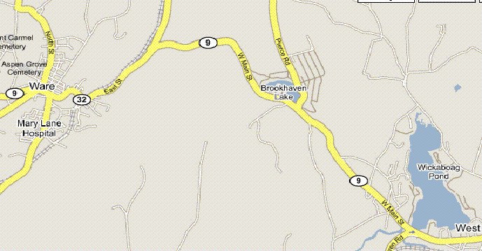
This is Route 9 between West Brookfield and Ware. I have a friend at work who told me he thought he saw rock piles by the side of the road in there. Since I just found things along a much shorter stretch of Rt 40, I would be surprised if there wasn't something to see along this stretch of Rt. 9. But what?
Please, if you see anything interesting along there, take a picture and send it in.
Monday, January 30, 2006
Curious small chambers and other structures. More from Norman Muller
According to Norman:
 I and a friend photographed tiny chambers in a boulder field, a circle petroglyph on a boulder, and a large platform cairn....There are four small chambers at the site, none of them large enough for a human, and I doubt they were animal cubbies or whatever they're called. Since the boulder field is laced with underground springs (one can hear water running in many places), perhaps as I said before these are shrines of some sort. Obviously they have no practical value, as viewed from a strictly utilitarian point of view, and given their location. The owner says that his grandfather and the person before him knew of the chambers but said they were always there. We are talking about the 1880s.
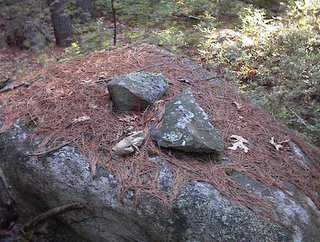
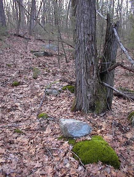
 Also attached is an image of a possible petroform on a ledge, surrounded by moss and lichen, and undisturbed for ages, judging by the lichen buildup and the soil around the stones. This feature is near the platform cairn, and in a beautiful area of cedar trees and luxurient reindeer moss... These are on private property.
 I and a friend photographed tiny chambers in a boulder field, a circle petroglyph on a boulder, and a large platform cairn....There are four small chambers at the site, none of them large enough for a human, and I doubt they were animal cubbies or whatever they're called. Since the boulder field is laced with underground springs (one can hear water running in many places), perhaps as I said before these are shrines of some sort. Obviously they have no practical value, as viewed from a strictly utilitarian point of view, and given their location. The owner says that his grandfather and the person before him knew of the chambers but said they were always there. We are talking about the 1880s.
 Also attached is an image of a possible petroform on a ledge, surrounded by moss and lichen, and undisturbed for ages, judging by the lichen buildup and the soil around the stones. This feature is near the platform cairn, and in a beautiful area of cedar trees and luxurient reindeer moss... These are on private property.
Do you see anything in it? A photo from Norman Muller
 According to Norman, this pile is "near or nearly over a spring in southwestern RI". I see a little ring of stones right behind the measuring rod. Also there is something a bit effigy-like about it. On the other hand, it looks damaged.
Sunday, January 29, 2006
Next to Snake Meadow Brook
 You can park and walk in from Rt 40 on the south side of Snake Meadow brook. You cross the brook and there is a little site. I could not tell what all was there under the snow but these few piles were visible and some rock-on-rocks in the area, several yards away.
 This pile looks like it barely escaped disaster.
 This type of site - a few low piles or rock-on-rocks in the rocky area near a brook or in a wetland, is a distinct type of site.
Roadside attractions in Westford
 This is next to Graniteville Rd just north of the main hill in Westford.
As you drive along Rt 40 there are several places where rock piles are visible from the car. Today there has been enough snow melt that rock-on-rocks are easy to spot. This one is near the entrance to the MIT Lincoln Lab
 A little east of there on Rt 40, I spotted a bit of a pile and got out to find five or six rock-on-rocks, pairs, and perhaps other things hidden under the snow.
 There was a hint that these piles might have had some alignments and had supported pointers (smaller rocks pointing up out of a pile).
Saturday, January 28, 2006
Friday, January 27, 2006
Check out:
http://turtlemountain.org/exhibits/mythandhistory/astronomy
It seems like Manitoba has really got it going on but there is as much material here in Massachusetts so I suppose it is everywhere between Mass. and Manitoba.
http://turtlemountain.org/exhibits/mythandhistory/astronomy
It seems like Manitoba has really got it going on but there is as much material here in Massachusetts so I suppose it is everywhere between Mass. and Manitoba.
The donation pile myth
If you go out looking for "rock pile", "stone mound", "stone pile", "cairn", "rock stack", or whatever, on Google, you will find lots of stuff about fishing [apparently underwater rock piles create a favorable fish ecosystem], terriers, monster trucks, etc. You will also find discussions of two kinds of Indian rock piles: Donation piles and Bison drive piles. Donation piles are described as piles located where a person fell in battle, or a where a person is buried, or where a memorial is erected. Each person in passing is supposed to place a stone donation on the pile. This is a worldwide idea and piles like this are described in Israel, Nepal, and probably many other places. Also, when cornered, New England academic archeologists acknowledge that - yes - it is known that Indians created such piles. For example there is a famous donation pile on "Monument Mountain" in Stockbridge Massachusetts (thanks N.M. for the info).
BUT here is why the idea is a problem for the study of rock piles: it trivializes the location of the pile and it trivializes the structure of the pile. If the location is, by coincidence, where someone happened to die in battle or was buried, this is not a location that is special in itself. Rather the location is special because of the events that occurred there. By contrast, most of the rock pile sites I see are located in a very specific topography and, I have come to believe, these spots are places of natural energy and aesthetics. So the location is not special because of the rock pile but because it already was special before the pile was built. It is a working hypothesis that the pile was built only in this location for a very good reason. The site layout is complex and needs to be studied not dismissed. This is exactly the opposite conclusion to the one arrived at from assuming "donation piles". It is also sometimes said that donation piles will tend to occur along trails (see that pdf link from earlier). So the structure of the "rock pile site" will be the structure of the trail that passes bye - of no particular interest. I find that rock piles are usually grouped - not strung out along a trail.
Also the shape of a donation pile is dictated by people randomly tossing rocks onto it, so the pile will have no structure worth speaking of. It will tend to be conical with sloping sides at the angle of repose for the materials.
Well these things are simply not true for the majority of piles that we study. They are usually grouped, the location is special, and they are either low or stacked but rarely conical - except when they have been vandalized. So if you hear someone talking about donation piles - check you wallet because they are implying that the location and the structure of the pile are of no interest. I think the opposite should be assumed until proven otherwise. The locations are special and the structures are special and usually matched to the location in some way. People who are so confident to talk about donation piles seem to be pretendeding to wisdom - another reason to check you wallet.
We should always beware of assumptions which block the study of the details. These assumptions are an impediment.
On the positive side, if you keep looking in Google you might eventually come across Turtle Mountain and Bannock Point. I'll go look for the links and put them in the list to the right if I can find them.
[later]My Point is: donation piles exist but are not the interesting part of the subject. They represent a small minority of the sites.
Thursday, January 26, 2006
Crossed pairs
The other day we were looking at some crossed pairs from a hill out west of here.

You wanna bet this isn't a specific type of rock pile?
 Here is another from Groton. This one is from behind somebody's house on a little hill. Right next to it were two other piles, each made from two rocks, and I suppose they are slightly damaged examples of the same thing.
 A simple way of elevating a pointer above the ground. What is that for?
Mass Historical does it again
Dear Reader:
Re: the FAQ pointed out by Bruce M.
If you should happen to encounter this nonsense from the Massachusetts Historical Commission (MHC), know that you are being lied to. The so-called "thorough" investigations have consisted primarily of schmoozing the developer, applying assumptions, and making a cursory site visit. I have watched it happen. Contrast this MHC statement with what USET said [and, yes, it is about rock piles]. The Indians have a much clearer understanding of their own sacred landscapes than do the representatives of the government which stole those lands. So consider the messenger:
I’m concerned that stone piles in a project area may be Native American grave markers. What should I do?
Piles or continuous walls of fieldstones are common in rural Massachusetts wherever there are rocky soils. When historians and archaeologists have conducted thorough, professional research into such stone piles, they have invariably shown that these features are not associated with the Native American settlement of Massachusetts. When it is possible to determine their origin, stone piles prove to be related to agricultural activities such as clearing of fields for pasture or cultivation, and/or marking property bounds during the eighteenth and nineteenth centuries, pursuits that were once much more common in what may now be residential suburbs. Because stone piles or walls often marked property lines or boundaries between different land uses such as pasture and woodlot, they are often in a linear row or other geometric pattern, some of which may be consistent with cardinal compass points, solstice sunrises or sunsets, or other celestial phenomena. http://www.anthropology.ccsu.edu/fraudsweb/frauds.htm
Some links from Bruce McAleer
These are recommended
http://www.umass.edu/nrc/pdfs/Draft_Cadwell_Management_Plan.pdf
http://www.sec.state.ma.us/mhc/mhcrevcom/revcomidx.htm
(see the FAQ)
Also see page 8 of
http://www.thesga.org/Profiles/Summer%202005.pdf
http://www.umass.edu/nrc/pdfs/Draft_Cadwell_Management_Plan.pdf
http://www.sec.state.ma.us/mhc/mhcrevcom/revcomidx.htm
(see the FAQ)
Also see page 8 of
http://www.thesga.org/Profiles/Summer%202005.pdf
Wednesday, January 25, 2006
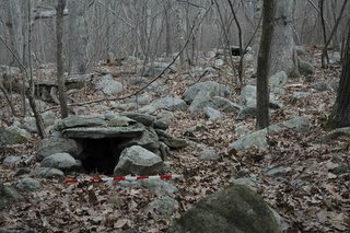
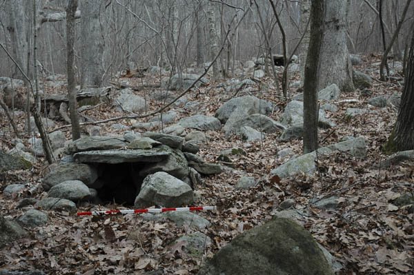
A possible souterrain
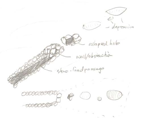
Various email today about underground chambers. Which reminds me of something like a collapsed souterrain I saw a few feet west of Rt 3 in Burlington. As I was exploring along there, I came across what looked like a stone-lined brook but, following it uphill a couple of yards, it turned out to be more like the entrance to a passage burial with a walled-off entrance, a collapsed ante-chamber and further deeper chambers, also collapsed, running in line up the slope. It was something like this cutting into a knoll: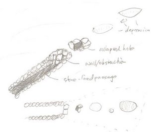 The upper part of the picture shows the features seen from 3/4 view. To the left is the stone-lined passage which gets deeper uphill - to the right in the picture. The passage is obstructed by a wall and uphill/beyond that is a collapsed structure with a hole hinting at deeper recesses underneath. Still further uphill and in line with that, are several depressions indicating other collapsed spaces. The lower part of the picture shows a "bird's-eye" view of the surface features.
Here is a view up the stone lined passage towards the walled off entrance. The dark behind it is where the roof is collapsed.
 And here is a view down in the opposite direction from the top showing some of the depressions which suggest collapsed passage.

Finally here is another detail of the wall and collapse. Perhaps someone will want to check it out more thoroughly someday.
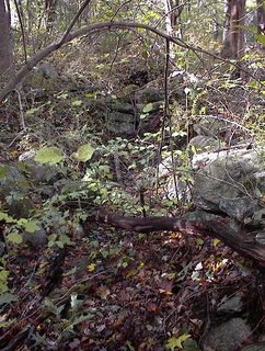
 Backside of Rt 3 is not the sort of place you expect to find something interesting.
 The upper part of the picture shows the features seen from 3/4 view. To the left is the stone-lined passage which gets deeper uphill - to the right in the picture. The passage is obstructed by a wall and uphill/beyond that is a collapsed structure with a hole hinting at deeper recesses underneath. Still further uphill and in line with that, are several depressions indicating other collapsed spaces. The lower part of the picture shows a "bird's-eye" view of the surface features.
Here is a view up the stone lined passage towards the walled off entrance. The dark behind it is where the roof is collapsed.
 And here is a view down in the opposite direction from the top showing some of the depressions which suggest collapsed passage.
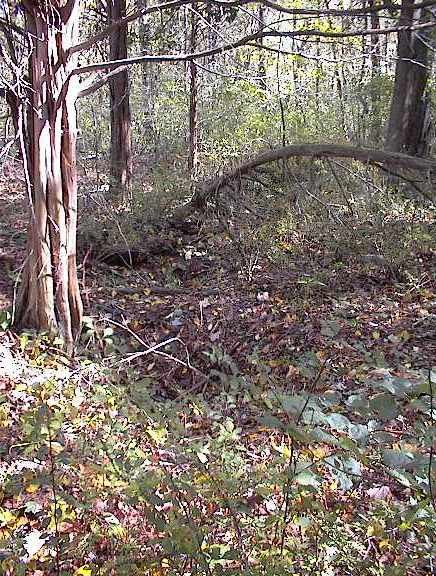
Finally here is another detail of the wall and collapse. Perhaps someone will want to check it out more thoroughly someday.
 Backside of Rt 3 is not the sort of place you expect to find something interesting.
Mysterious Stacks from Nova Scotia
Check this out - a web page about St. Mary's River in Nova Scotia
http://www.geocities.com/maisie42/index.html
Very impressive old moss covered rock piles.
http://www.geocities.com/maisie42/index.html
Very impressive old moss covered rock piles.
Tuesday, January 24, 2006
Open Thread
Click on the word "COMMENTS" just below and it opens a text editor where you can type something. I wish you would. I don't think you need to log in.
Look carefully
 Maybe sometimes a rock on rock is actually part of a more complex structure. It sure seems like it in this picture. This is from a rocky lowland one lot away from a brook in Stow, from right near that boat-rudder.
Monday, January 23, 2006
Hilltop Sites
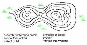
 This is an abstract drawing of how the rock piles sites are located on a group of hills out west of here near Rt 117. The road is the straight black line, the hills are the ovals, and the sites are in gray. It is interesting that all the sites are more-or-less south facing. Exploring the southwest shoulder of the hills out here has become a standard strategy for finding sites. That helped find the Long Hill Rd site of earlier.
Doesn't it seem a reasonable hypothesis that when we find two sites using the same topographic strategy, that the sites might have a common function? More specifically isn't it reasonable to suppose these sites on these hills have a similar function? The rock piles there have a lot in common too.
Boat Rudder shaped rocks
This is from Stow, MA.
 It is a particularly nice example of a rock shaped like a boat rudder and used in a rock pile. I have seen a lot of this shape, most often part of a pair on a rock for example this one from Acton:
 Is this (from Boxborough) a variation?
 Perhaps someone would say it is meaningless. I say it happens too often and must mean something. Let's start guessing and cross checking with other things. My best guess is that is represents a heart.
 It is a particularly nice example of a rock shaped like a boat rudder and used in a rock pile. I have seen a lot of this shape, most often part of a pair on a rock for example this one from Acton:
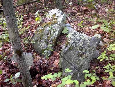 Is this (from Boxborough) a variation?
 Perhaps someone would say it is meaningless. I say it happens too often and must mean something. Let's start guessing and cross checking with other things. My best guess is that is represents a heart.
Sunday, January 22, 2006
Skywatching sites on the hilltops
 There are three adjacent hilltops out at the western border of Middlesex County - each with rock piles that hint at a function which involved watching events in the sky. The piles and their placement have directionality and alignment. I do not know why it took so long for me to spot, plan access to, and arrive at, this hilltop today but it is just like its adjacent neighboring hills: skywatching related rock piles - piles with directionality and a fine view out over the valley. All three hills have sites facing south and west, and very little on any other portion of their summits.
 Today the piles defined their directionality by being elongated. Most of them had their major axis pointing east-west. One was more north-south. At the other two summits nearby: one has piles that each support a pointer rock (like the crossed pairs below but more substantially constructed).
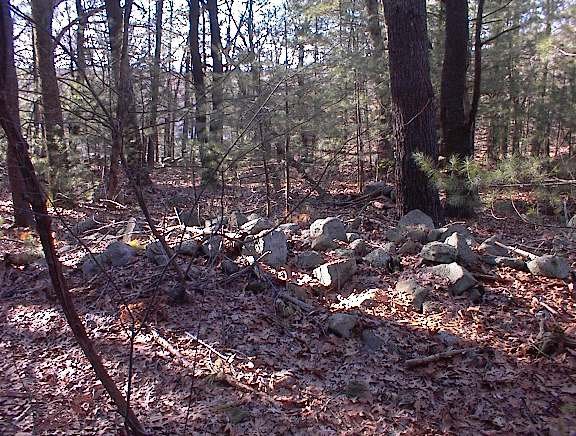 Another hilltop neighbor has piles which are evenly spaced and placed in straight lines. I believe today's elongated piles might have once supported pointer rocks. But they have been broken down to mere stubs of what they once were.
 Hills along the Rt 495 corridor
Rt 495 out west of here runs north/south through the valley of Beaver Brook (flowing north into the Nashua River) and Elizabeth Brook (flowing south into the Assabet River). There are wonderful rock pile sites down throughout this valley. The Boxborough Esker, made famous by Mavor and Dix in Manitou is here, as are some of the stone chambers they discuss. If you visit every hilltop out here, you'll find the rock piles sites. Hilltop sites don't happen over here in central Middlesex County but they are the standard out there along the border with Worcester County. Towns of interest, I call it the "Bobo corridor", include Boxborough, Bolton, Harvard, Littleton, and Stow. These are USET protected towns (except Harvard which missed the list).
 I noticed an unexplored hilltop on the topo map last week and today, it being Sunday, I had a chance to drive over there and check it out. Well, all the hills near this have sites that seem related to sky watching. The sites are always on the southern and/or western side of the hilltop. Here are examples of one type of structure I found, similar to some things I saw on a hilltop in Groton: crossed-pairs of stones, like "rock-on-rock" but seemingly designed to support the upper rock in a particular position.

 Later in my walk today, I actually capture some rock-on-rocks in the act of forming an alignment. Usually they are not so easy to photo. Here they are:
This may be more of the same from nearby:
I'll continue the site description in the next entry.
 I noticed an unexplored hilltop on the topo map last week and today, it being Sunday, I had a chance to drive over there and check it out. Well, all the hills near this have sites that seem related to sky watching. The sites are always on the southern and/or western side of the hilltop. Here are examples of one type of structure I found, similar to some things I saw on a hilltop in Groton: crossed-pairs of stones, like "rock-on-rock" but seemingly designed to support the upper rock in a particular position.
 Later in my walk today, I actually capture some rock-on-rocks in the act of forming an alignment. Usually they are not so easy to photo. Here they are:
This may be more of the same from nearby:

I'll continue the site description in the next entry.
Mary Gage's classification of stone structures
This may be of interest. http://www.stonestructures.org/Guide_2.0.pdf
A rock-on-rock
 Here is one more picture from Friday. It was the only structure on the west side of the brook at the site I described.
Saturday, January 21, 2006
Perched boulder in Sudbury
 You might see this on Old Marlboro Rd in Sudbury. It is part of a line of large rocks - although it is the largest. On the other side of the street the line continues as a stone wall.
This is not at all the kind of thing you expect to see in Sudbury. Pretty nice though.
Elongated Structure from Sudbury site
Here is a portion of an elongated low rock pile that runs for perhaps 30 feet down hill towards the stone wall at the edge of wetter ground. The structure is more complicated that a simple line but hard to grasp and impossible to photo. Anyway, here is a portion of it leading down to the wall:
 Why not post another picture? It might give a clearer picture:

 Why not post another picture? It might give a clearer picture:
Wetland sloping site in northern Sudbury
I was studying the map of southern Concord and saw one place near Second Division brook where I had not been and thought it might be worth exploring. Over in south western Concord it is all sand and white pine trees, not good for finding rock piles, so driving along I was surprised to get to a slightly more rock area. I saw what looked like an interesting stretch of woods by the road and, uncommitted, decided to take a quick look. The further I got from the houses the more the woods continued, so I kept going until, hey! what is this? Stepping out of the car and walking up to a rock piles is always nice. As I walked around there were perhaps five or more low ground piles. Like this:
 This pile, with the one larger rock, is more like a marker pile than a burial. This next one is more like a burial.
 These piles were on a slight slope leading down to a wetland. A minor site, missing being in Concord by only a few yards. A most interesting feaure was a linear/elongated rock pile that was somewhat complex shaped, and not possible to photo. It was like a low ridge of cobbles:
 Stepping out of the car and walking up to a rock piles is always nice. As I walked around there were perhaps five or more low ground piles. Like this:
 This pile, with the one larger rock, is more like a marker pile than a burial. This next one is more like a burial.
 These piles were on a slight slope leading down to a wetland. A minor site, missing being in Concord by only a few yards. A most interesting feaure was a linear/elongated rock pile that was somewhat complex shaped, and not possible to photo. It was like a low ridge of cobbles:
?????
Blogger seems to get more and more unhappy the more pictures I add, until it stalls out. Cannot show you the linear arrangement here. OK I'll put it in the next post.Friday, January 20, 2006
A curious "fire circle"
This is from the brook-side site described earlier, and was underneath a fine old hemlock tree.
 We see a line of rocks, a circular structure and another rock behind. The rock behind is actually supported on two other rocks like a small altar and the ring of stones might have had a fire inside it. We are facing roughly south.
 We see a line of rocks, a circular structure and another rock behind. The rock behind is actually supported on two other rocks like a small altar and the ring of stones might have had a fire inside it. We are facing roughly south.
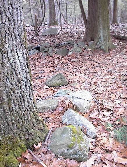
A small site by a brook
 During the commute there are lots of nice looking woods visible along the highway and my plan is to leave work a little early on Friday afternoons and explore what I can. One place that looked intriguing was where a brook comes down to the road in a shallow valley through what looks like undisturbed woods. I get a quick glimpse of this from the car as I pass. [The brook is shown as a pale blue line in the above map fragment.] Today I left work, drove to a place near this woods, parked behind a new building, walked eastward, and thought it looked like old woods and old ground cover. I crossed a wall and went down to the brook and things looked even more un-disturbed. A split rock across the stream caught my eye and when I got over to it, I was in a small rock pile site.
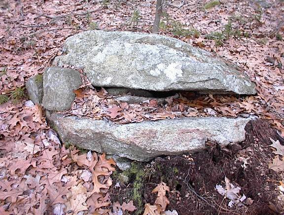 This is a typical split-wedged rock. You can think what you want about it. I think the rock looks deliberately split - you can see where someone whacked it.
 Nearby there were numerous rock-on-rocks.
 In all, there might have been more than 10 rock-on-rocks nearby.
Also there were a few inconspicuous ground piles and a few supported ones.
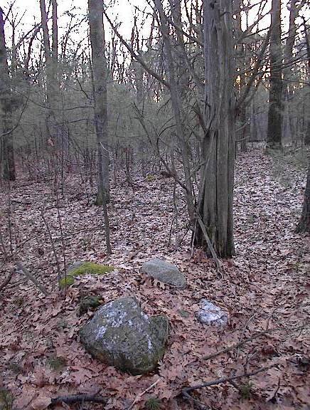 I have a soft spot for cedar trees growing next to rock piles; especially when there is some death symbolism nearby, such as the white quartz rock in the pile shown here. I am suspicious that perhaps cedar trees were planted as memorials; not for burials but for reminders.
Here we are on the eastern side of the brook looking back to the west at the sun which is low in the sky at a few minutes to four on a January afternoon.
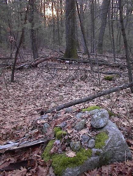
Down closer to the brook there were some piles made with larger stones more of a sense of crude alignments. A curious feature near the original split wedged rock was what looked like a fire circle, lined up with a row of cobbles, and another rock pile structure.
[I'm having trouble posting more pics, I'll try again later]
Subscribe to:
Posts
(
Atom
)