
Friday, December 31, 2010
Stone tool from Greene county NY
Reader Sarah writes (in part):
Attached is a rock that I found on my property last fall...This rock was found around an area that we call a knapping station on our property. I reside in Greene county NY [near the] Athens NY Paleo Flint Mine. My question is could this rock be a point? You can see where flaking was done.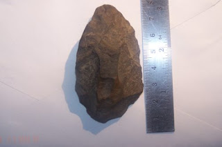
Attached is a rock that I found on my property last fall...This rock was found around an area that we call a knapping station on our property. I reside in Greene county NY [near the] Athens NY Paleo Flint Mine. My question is could this rock be a point? You can see where flaking was done.


A Snake's Tale about a Niche

Thursday, December 30, 2010
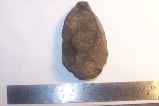
Large stone "arrowhead" from southeastern MA
Chris P. writes:
I stopped by a few places on Saturday morning. I wanted to look for arrowheads one last time this year before the snow came. I'm glad I did!
I stopped by a few places on Saturday morning. I wanted to look for arrowheads one last time this year before the snow came. I'm glad I did!

Wednesday, December 29, 2010
Niche in Washington, MA
Norman Muller writes:
Speaking of niches: That niche you located on an outcrop with the stone cairn nearby is similar to a striking combination that Philip O'Deane showed me in Washington, MA, some years back. Not only was there a niche similar to the one you found, with a cairn nearby, but below it was a single large slab supported at either end by small cobbles; this was not enclosed at one end as was the nearby niche. O'Deane referred to this triple combination (including a small niche under the boulder with the cairn on top) as "three wombs." This combination is unique, and I've never seen anything quite like it since. Within the same town was a marvelous cairn with a niche at the base and topped with a large piece of milky quartz.


I believe Philip passed away a few years ago.
Tuesday, December 28, 2010
Thursday, December 23, 2010
Wednesday, December 22, 2010
Stone niche - in context
I want to show a few other pictures of the place, off Rocky Hill Rd in Groton MA, where I found the stone "niche" I posted the other day. It was adjacent to another small rock pile:

 This occured on the southern/western facing sides of a low ridge, looking over a slight valley to another parallel ridge a hundred yards away. Exploring that other ridge is for another day. Meanwhile, there were a couple of other piles in the same general position a bit down the (first) ridge from this niche. Here are some of them:
 The whole area was scattered with small clusters of ceremonial structures. Across the road was the older site I described here.
Odd Stuff - other curious shaped rocks
Norman Muller writes:
About six years ago, I had a tour of Track Rock Gap in Georgia. On the east slope of the Gap, opposite where the petroglyphs are (from which the Gap got its name) are a number of terrace walls and cairns, and on top of one wall, partially obscured by briars and brush, I found a stone “foot,” fashioned or weathered from a pink colored stone.  Carey Waldrip, who showed me the site, had not noticed this before. I was reminded of this when I saw your blog and the curiously shaped anvil stone that was just posted. Certainly the Indians were intrigued by such oddly shaped stones, and probably set them in various places for others to see and venerate.
Split wedged rock - in context
Another small scene from Rocky Hill Rd Groton, with a solitary rock pile and a split-wedged rock: and behind it
 Closer:
 and behind it
 Closer:
Interesting rock from Acton
Reader Vin writes:
Here's an interesting rock for ya.
 This is setting in a stone wall in Acton, I removed it for this photo and
have replaced it.
The base is about 12" x 12".
The height is about 12"
The center 'column', which is shaped like the profile of an airplane wing,
must have been carved out by running water.
Next to this stone wall there is a trench, and on the other side of the
trench there are a couple 6 foot high ledges or mounds of buried rock, with
a smaller rocks piled on top.
It looks like this rock came from an underground cavern, and it might have
come from those 2 mounds (assuming there's a small cavern in there), or it
might have been carried and placed here.
Tuesday, December 21, 2010
Rocky Hill Rd - Groton MA
 Things have conspired to stop me blogging, mainly a dead computer. Anyway, I wanted to mention this site before going on Christmas vacation and entering another blogging "dead zone".
Groton is in the category of town that "almost always disappoints", yet my recent experiences in southern NH led me to think it would be worth following a "edge of water" exploration strategy over in one of the rock parts of town. In the past I found a few traces on the walk up to Horse Hill from Rocky Hill Rd, and coming home I was driving slowly looking out the car window:
 On my first visit (when I forgot my camera last weekend) I poked into the woods, wondering if there was going to be a bigger "mound with hollow" down at the water's edge. Saw encouraging traces:
 And then something bigger loomed in the background:
 Closer up, yes there is a sort of hollow:
 But this 'mound' is actually more triangular than rectangular. Here is a view of the apex of the triangle:
 In the vicinity there were some marker-like piles. Perhaps "ski jumps"?
 If I had to say, I would call this one rectangular:
 So, what with one thing and another, this is not exactly a typical Wachusett Tradition site. Instead (because there were a variety of piles around, some in better shape than others) it seemed like the whole area had different styles of rock pile mixed together. As if this spot was important and ceremonies continued to be performed here at different times.
On the other side of the road there was one more pile in the "cluster". This one is also a bit rectangular, with some symmetry about the larger rock (which looks fire-cracked).
 I continued to explore on this other side of the road and found a few other clusters of piles in there. So the whole area has quite a few minor sites in addition to the larger 'mound'. Much more than I would expect from Groton and certainly worth exploring some more in the future.
And just for reference, I frequently find something like a buried stone wall at these "Wachusett Tradition" sites. Something even older and more beaten down than the rest. There was one of those here as well.
Spring Pond Woods - Salem MA
Tim MacSweeney found this link:
http://www.springpondwoods.com/p/maps.html
There are some proppped boulders in the "Photos".
http://www.springpondwoods.com/p/maps.html
There are some proppped boulders in the "Photos".
Sunday, December 19, 2010

Thursday, December 16, 2010
Scene from Mt Elam
 What a riot of colors! I think we do not realize it, when fall is upon us.
 I took so many photos on the field trip to Mt. Elam that I never could bring myself to blog about it. Perhaps I can post a few un-systematic odds and ends instead.
[In the end, I lost them all to a lost harddrive]
Wednesday, December 15, 2010
Have been sick - sorry no posting
I found something last weekend but forgot to have a camera along. I'll hope to get it next weekend. Till then, nothing much to report.
Monday, December 13, 2010
Stone Seat
Reader Vin writes:


 Probably a great place to sit and watch the sun rise.
Here are some shots of a very comfortable place to sit, on the east side of a hill, with a view due east.


 Probably a great place to sit and watch the sun rise.
Thursday, December 09, 2010
Shelton Stone Mound Complex, 1CA637, Calhoun County, Alabama
Norman Muller writes:
Attached is the notice of a stone mound site in Alabama that the Archaeological Conservancy purchased ,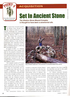 plus a map of one of the mound clusters (Group 2).
 There are three such clusters at the site, and this one has the greatest variety of features. The illustration comes from Dr. Harry Holstein’s report: “Preliminary Investigations at the Shelton Stone Mound Complex, 1CA637, Calhoun County, Alabama,” published by the Archaeological Resource Laboratory, Research Series No. 3, Jacksonville State University, 2007.
Attached is the notice of a stone mound site in Alabama that the Archaeological Conservancy purchased ,
 plus a map of one of the mound clusters (Group 2).
 There are three such clusters at the site, and this one has the greatest variety of features. The illustration comes from Dr. Harry Holstein’s report: “Preliminary Investigations at the Shelton Stone Mound Complex, 1CA637, Calhoun County, Alabama,” published by the Archaeological Resource Laboratory, Research Series No. 3, Jacksonville State University, 2007.
[T]his is a significant development, as this represents, I believe, the first time that a ceremonial stone mound site has been recognized and preserved by the Archaeological Conservancy.

Wednesday, December 08, 2010
Stevens Hill - Stow MA
 Not sure why it took me so long before finding a way to explore this hill but the access is difficult and I only just found out there is a conservation land entrance from the residential road (EdgeHill Rd) that got back in there. Once in, I scouted the northern slope of the hill from the top as I traversed over from right to left and up to the top of the main hill, down to its southern edge and then back around, clockwise, at a lower elevation. And swinging back across the northwestern slope of Stevens Hill I found an enclosed area with rock piles:
 I assume this is a marker pile site even though there is little evidence of even spacing or of piles in lines. But every other major hill in Stow has a rock pile site down somewhere on its slopes and most of the others are pretty clearly marker pile sites. So I'll lump this with the rest and consider that - in terms of the hills of Stow - I now have the complete set. A possible confirmation of the "marker pile" identification is that several of the piles had a longer "pointer" rock hanging over one edge:
 Such things, if not just random, have always seemed to indicate a means of more precise positioning of the pile, or its shadow, or something... Here are some other piles from there, not a lot of structure to them:
 A typical hillside scene, from this part of the countryside. More:
 Here is a classic "twins" pile. Note the parallel shape of the component rocks:
 The site continued across and down the side of the hill, with separate clusters of piles like this:
 [You may have noticed a lot of blogging and new sites lately. I have been taking a vacation between an old job that had grown hateful and a new one about which I am quite optimistic. I start tomorrow and expect blogging will be noticeably reduced going forward. But while on break I went exploring every other day. The best finds were the site near Peppercorn Hill and the Gumpas Beaver ponds. But quite a few smaller nondescript sites like the above.]
Crude Stone Knife - stemmed like a Stark Point
Found this last weekend. Not much to show for an hour of prospecting but these fields have been picked over a lot and not plowed deeply in some time. Here it is, front and back:
 The stemmed base (at the top of the picture) is equivalent to the stemmed base we see on Merrimack points and, in particular, "Stark" points from the early-to-middle archaic of 6K years ago.
Clearly the ancients did not always have good stone tool knapping material available. Here, instead, they used a slate/basaltic cobble from the local glacial till. But you have to really know what you are doing to get a working edge from such low grade material. Here are views of the edges: and
and Not a museum piece but, probably, most artifacts are like this - crude and disposable.
 The stemmed base (at the top of the picture) is equivalent to the stemmed base we see on Merrimack points and, in particular, "Stark" points from the early-to-middle archaic of 6K years ago.
Clearly the ancients did not always have good stone tool knapping material available. Here, instead, they used a slate/basaltic cobble from the local glacial till. But you have to really know what you are doing to get a working edge from such low grade material. Here are views of the edges:
 and
and Not a museum piece but, probably, most artifacts are like this - crude and disposable.
Subscribe to:
Posts
(
Atom
)