Monday, December 23, 2019
Tuesday, December 17, 2019
Flume Pond - Sippewisset, Falmouth MA
Been a while since we had a standard report:


You keep going along the trail for a minute and see a rock pile off to the right. An older trail leads down to the water on the right (north side) to a place where a boat would be easy to launch. As the trail goes down to the water a small collection of rock piles appear. Upon investigation there are several different clusters of piles out along the ridge, and all the way to the tip of the higher ground sticking into the pond.


Flume Pond is a Falmouth "300 Hundred Committee" conservation land. Several stone walls (in light blue) cross a ridge of higher ground next to a pond, that was probably connected to the ocean at one time. Along the north side of a ridge are a couple of "grids" (upper dark blue outlines) and on the south side, where another wall comes down to the very tip of an inlet, there were several features: a large boulder connected to the wall, a couple of small rock piles (lower dark blue outline) and a linear earthen "berm" (orange line) that parallels the wall and the water. I would have called it a ditch except it is above and parallel to the water. This spot, by the inlet, is a place where brackish water is coming up directly under the oak trees.
You walk along the ridge following a stone wall. Right at the beginning is a vernal pond and a small bit of wall wraps the pond. Next to the vernal pond, a fine example of a split wedged rock:

You keep going along the trail for a minute and see a rock pile off to the right. An older trail leads down to the water on the right (north side) to a place where a boat would be easy to launch. As the trail goes down to the water a small collection of rock piles appear. Upon investigation there are several different clusters of piles out along the ridge, and all the way to the tip of the higher ground sticking into the pond.


I poked around more carefully and would say there are 20 or so piles in the whole area. Yesterday I spent a while looking closely at the first collection of piles on the northern side of the ridge and going down to the water. I started to notice the piles were a bit evenly arranged along lines and started looking for missing piles where the "grid" had me expecting them - ending with my brushing leaves off of several piles I did not see at first. Then I tried to memorize the layout and, getting it at least viusalized, was able to record the layout with bits of dead leaf on a rock:

(Click in to see it better.)
I also explored more extensively in a bulbriar patch that covers the southern side of the ridge. Where the inlet cuts into the land and meets another stone wall, there were a couple of little rock-on-rocks right down at the edge:
 Looking south over the final inlet:


Just to the side of this, as shown in the map fragment, was an unusual earthen feature. Like a stone wall, parallel with a stone wall (shown in previous picture) but made of earth:


Otherwise this is a site with several different typical "grids". In my experience these are usually found near larger mounds, often lower and less conspicuous than the piles of the grid. I did find a larger "bump" with a few rocks poking out that might meet that description.
Tuesday, December 10, 2019
The Swanzey Fish Dam
A Large, Precontact Native American Stone Structure in SW New Hampshire
by Robert
G. Goodby, Sarah Tremblay, Edward Bouras (2014)

"The Swanzey Fish Dam is a large
V-shaped stone structure in the Ashuelot River of southwestern New Hampshire.
One of the few substantial stone sites in New England with clear archaeological
evidence for a Native American origin, it is assumed to have been used for the
harvesting of anadromous and/or catadromous fish. Archaeological data
demonstrate that the dam became a focus of Native American activity by the
Terminal Archaic Period and continued in use into the Contact Period. While one
of the first such dams to be documented in New England, the Swanzey Dam is
shown to be part of a larger pattern of stone dam construction across eastern
North America.

The
Swanzey Fish Dam was known to the earliest Euroamerican settlers of Swanzey.
The most detailed description comes from an 1888 account by Keene resident and
respected naturalist George Wheelock (cited in Griffin 1904:140): “The low
water in the Ashuelot, occasioned by the repairs at the Swanzey mill, has
exposed the old traditional Indian dam two miles above. Indians were lazy, and
this work of theirs is the more surprising on this account...the river at this
point is now almost a rapid and strewn with boulders for thirty rods or so. It
is less than a hundred feet wide, but the dam being in the shape of a harrow
pointing downstream is more than that distance. By skillful stepping it is
possible to pass the point of the harrow, the apex of the dam, and somewhat
farther. It is made of stones such as a man could lift, picked up in the stream
above. It varies from six to twelve feet in thickness, according to the depth
of the water. It looks like a tumble down wall mixed with gravel, but it must
have caused weeks of labor....Below the dam is a flat boulder reached by
stepping-stones....Near by the old dam lives Jonas L. Moore. Here lived his
father and grandfather before him. For one hundred and thirty years this has
been called the Indian dam...The elder Moore dug up a half peck of arrow and
spearheads, all in one pocket....Some twenty Indian fire-places have been
ploughed up here. These were simply circles in the middle of the wigwam, paved
with stones from the river.”
Racist stereotyping
aside, this account is significant in a number of respects, most notably in
dating the recognition of the dam as a Native American creation to the earliest
Euroamerican settlement of Swanzey in the mid-18th century...
Only a handful of wooden fish weirs have been
documented in New England, and prior to this study, no stone dam has been
conclusively shown to be Native American in origin…
… Research at the Swanzey Fish Dam site has resulted in a
detailed description of the dam feature, has shown that the dam was a focus of
Native American activity, and has definitively dated this activity to the
Late/Terminal Archaic and Contact periods. This research has also ruled out a
Euroamerican origin for the dam, and has shown that, as in much of the eastern
United States, substantial stone structures were constructed by Native
Americans in New England."
Monday, December 09, 2019

Sunday, December 08, 2019

Thursday, December 05, 2019
Canadian Shield rock art as Gesamtkunstwerk : Aesthetics of place and landscape

Global
Rock Art. Annals of the XIV World Congress of the International Federation of
Rock Art Organizations, Piauí, Brazil
(Excerpts:)
“…Substances, such as red stone, quartz, copper,
crystal, shell, and certain woods, such as
birch, were spiritually important and their aesthetic
properties of colour and texture were exploited. The use of exotic stones,
which were traded at a long distance, stems back to
the Paleo-Indian period (10,000-,000 BC)…
The exploitation of the natural shapes and colours of stones is also evinced from the Shin-ga-ba-was-sins, “curiously wrought boulders of rock” that resembles human or animal forms. These stones, which were believed to be imbued with spiritual powers, had sometimes features such as eyes painted in order to accentuate their organic shapes. Certain stones were imbued with special significance. For example, the Mistassini quartzite was called by the Eastern Cree of Québec “Stones that look like fat,” fat being an esteemed substance. Evidence of its exploitation for tools could go back to 4,000 years ago and the quarry itself was regarded as a sacred place...
The exploitation of the natural shapes and colours of stones is also evinced from the Shin-ga-ba-was-sins, “curiously wrought boulders of rock” that resembles human or animal forms. These stones, which were believed to be imbued with spiritual powers, had sometimes features such as eyes painted in order to accentuate their organic shapes. Certain stones were imbued with special significance. For example, the Mistassini quartzite was called by the Eastern Cree of Québec “Stones that look like fat,” fat being an esteemed substance. Evidence of its exploitation for tools could go back to 4,000 years ago and the quarry itself was regarded as a sacred place...


According
to the archaeologist George Hamell (1983), among North-eastern Woodland
Indigenous peoples, substances such as copper and crystal, which can be characterized
as shiny, translucent and light-coloured, are metaphors for Light, Life and Knowledge.
HAMELL (1983: 5) claims that: When consecreated [sic] to ritual use, shell, crystal,
and native copper, and artifacts made from these substances are traditional
material culture expressions of “metaphysics of light” shared by the Northeastern
Woodland Siouans, Algonquians and Iroquoians. Within this metaphysics “Light”
is a metaphorical conceptualization for semantic domains of highest cultural
value or significance: “Life,” “Mind,” “Knowledge,” and “Great Being”. As light,
bright, and white things, shell, crystal, and native copper, are “good to think
(with)…”
These substances, appreciated for their
whiteness, transparency, reflectiveness and lustre, were obtained from
underwater manitous such as the mythical Snake whose body “looked like brass”
and “eyes and horns shone like a mirror.”
White
shiny objects were endowed with special powers. Kohl (1985[1860]: 414-415) recounted a story
relating to the sacredness of white: An Ojibbeway, of whom I inquired why a
white colour was so specially esteemed by the Indians, told me that the cause
was as follows:
“When
the first man on earth fell sick, and saw death before his eyes, he began to
lament and complain to the Great Spirit about the shortness and suffering of
this life. [To help the Great Spirit sent messengers bringing the Midewiwin ].
These messengers brought down at the same time a white hare-skin, the feathers
of a white-headed eagle, and a medicine-sack of white otter-skin. These contained
all the Indian medicines and benefactions of the Great Spirit to mankind. And
from this time forth white became a sacred colour among the Indians…"
“A
Gesamtkunstwerk (German: [gəˈzamtˌkʊnstvɛʁk], translated as "total work of art",
"ideal work of art", "universal artwork", "synthesis
of the arts", "comprehensive artwork", "all-embracing art
form" or "total artwork") is a work of art that makes use of all
or many art forms or strives to do so.”
Wednesday, December 04, 2019
Monday, November 25, 2019
More 'arrowheads' from North Kingston, RI
Reader Joshua H. writes:
I recently found what I believe to be an argillite guilford round base, quartzite point, three unusual argillite points with two that are very similar to the points described in the thread on arrowheads.com, "narragansett bay argillite spear point tips" and the other is tri-faced and most likely untyped...also a rhyolite adena blade, quartzite blade and (please don't laugh) a crowfield point made out of slate!! I know it sounds crazy but it has all the characteristics of the shape. I hope to get all my finds authenticated in the future.


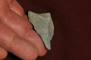


I recently found what I believe to be an argillite guilford round base, quartzite point, three unusual argillite points with two that are very similar to the points described in the thread on arrowheads.com, "narragansett bay argillite spear point tips" and the other is tri-faced and most likely untyped...also a rhyolite adena blade, quartzite blade and (please don't laugh) a crowfield point made out of slate!! I know it sounds crazy but it has all the characteristics of the shape. I hope to get all my finds authenticated in the future.


Here is a photo of the "crowfield":

Sunday, November 24, 2019
By a vernal pond in Sippewisset, Falmouth MA
For readers unfamiliar with the supposed 'grammar' of split-wedged rocks, a vernal pond is a small water source, a place full of spirits. Here, a spirit in the split rock has been blocked from coming out. This spirit - or perhaps the blocking of it - is connected loosely, through a few widely placed rocks, to the stone wall in the background. This wall makes a 'V' with another wall [not shown] just to the right of the picture, on the other side of the low place of the vernal pond.
Thursday, November 14, 2019
Makiawisug
(The Little People) of Mohegan Hill, Uncasville
May, 2017 by Ray Bendici - Filed Under: Legends, Odd
Things, Weird Places
"Described by some as knee-high tall, the
Makiawisug wear moccasin flowers for shoes... They are believed to have the
power of invisibility, and have been reported to carve symbols into stone. In
addition, they supposedly create stone piles, which are used to help protect
the Mohegan. In 2012, a development in the area was interrupted by tribal
members wanting to preserve such piles, described as "being made of the
bones of Mother Earth" and containing messages that "guide generation
after generation of Mohegan people."

Makiawisug: The Gift of the Little People Hardcover
– December 1, 1997
by Melissa Jayne Fawcett (Author), Joseph Bruchac
(Author), David Wagner (Illustrator)
"
Tuesday, November 12, 2019
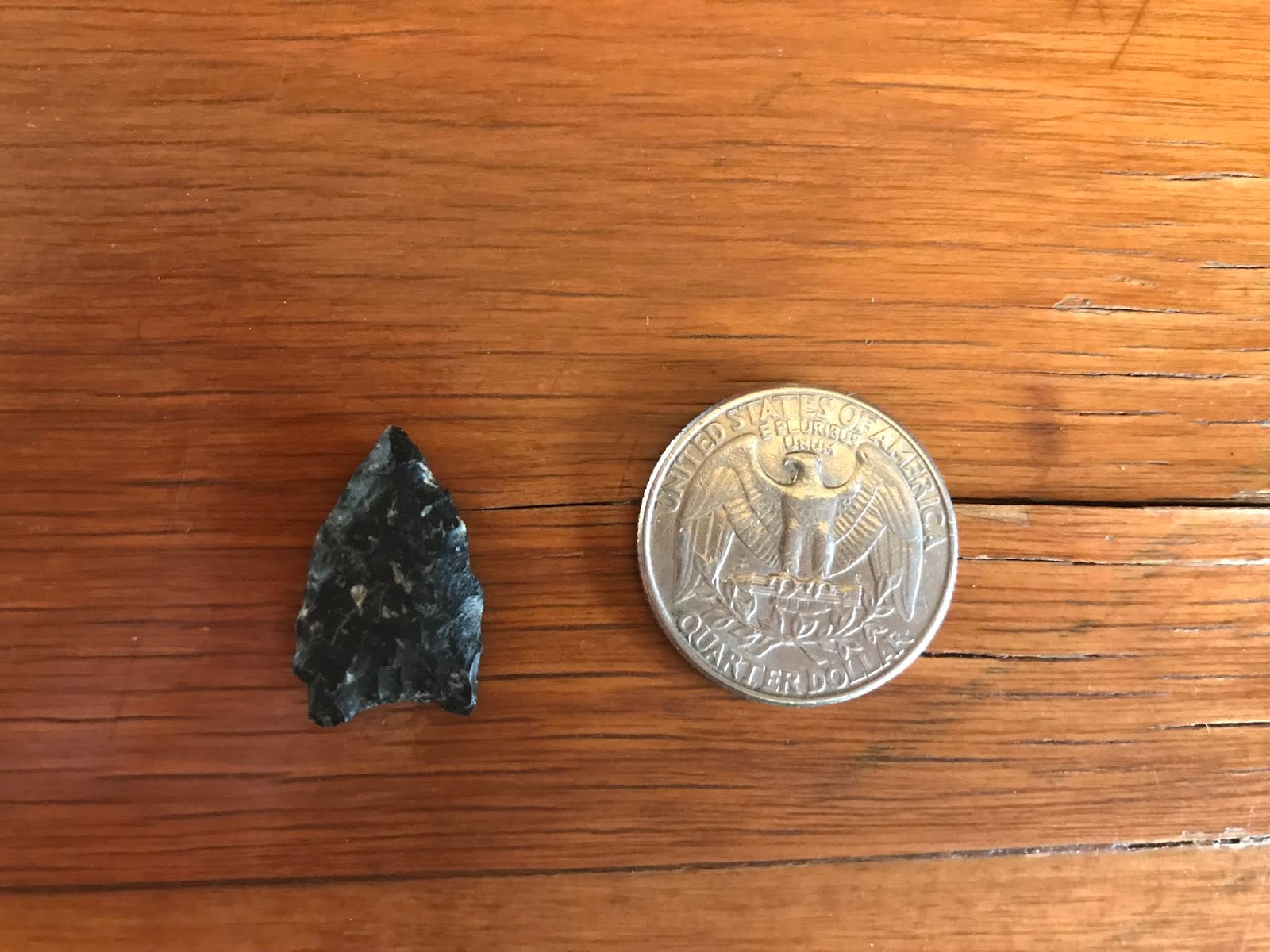
Small clovis-like point from Concord
I never showed this one:


 Found at the wastewater facility cornfield - it was snowy and only a narrow strip of mud was melted out along the top of each corn row. I bent down to investigate what turned out to be a goose poopy, and while my head was close to ground I spotted this little point. I should not have found it otherwise.


The ghosts of the past seen on the pathways in a dust of snow or...
Maybe someday this technology can be applied to rock pile sites.
https://phys.org/news/2019-11-ghost-footprints-pleistocene-era-revealed.html
I wrote a post somewhere about seeing the ghosts of people walking on the old paths, visible only when there is a dust of snow. Cannot find the post.
https://phys.org/news/2019-11-ghost-footprints-pleistocene-era-revealed.html
I wrote a post somewhere about seeing the ghosts of people walking on the old paths, visible only when there is a dust of snow. Cannot find the post.
Monday, November 11, 2019
Friday, November 08, 2019

Sunday, November 03, 2019
Tolland Cairns
Reader Michael H. writes:
North side of route 57, Tolland, MA just west of where Richardson Brook crosses road.


North side of route 57, Tolland, MA just west of where Richardson Brook crosses road.


Rockport Turtle
Reader Scott B. writes:
...I believe that the head on the 'turtle' is aligned to true north and that there are standing stones at 30 degree intervals around the turtle mound....

...I believe that the head on the 'turtle' is aligned to true north and that there are standing stones at 30 degree intervals around the turtle mound....

Saturday, November 02, 2019
"Geoglyph" (Utah)

Geoglyph
Black Friday 2014 trip: udink.org/2014/12/04/mussentuchit-willow-springs-and-hebe/
Dennis Udink
Friday, November 01, 2019
Alan Cressler: Rock Piles and Rock Walls

Rock Mound, Indian Rocks Park, Big Canoe, Dawson County,
Georgia 6

Dick Ridge Wall, Chattahoochee National Forest, Walker
County, Georgia 1
"Random rock walls on ridge tops of the southeastern
U.S. are highly debated. Theories include: animal fences, rock removal for
cultivation, fortifications, and prehistoric purposes. Archaeological
investigations often reveal nothing conclusive about purpose or who constructed
them..."

Pine Mountain Structure, Pine Mountain, Georgia, Jannie Loubser
2
Complete Album:
https://www.flickr.com/photos/alan_cressler/albums/72157678484764728/with/12895105494/
Thursday, October 24, 2019
Ancient stone circle and pyramid mound just discovered in Quebec, Canada here at LeTerrain. [YouTube]
I like this one, even without watching it through:
https://www.youtube.com/watch?v=JTFLgp4RVXc
https://www.youtube.com/watch?v=yyf_YUXiEC0
https://www.youtube.com/watch?v=JTFLgp4RVXc
https://www.youtube.com/watch?v=yyf_YUXiEC0
Wednesday, October 23, 2019
Tuesday, October 22, 2019
Monday, October 07, 2019

Sunday, October 06, 2019
YouTube finds
https://www.youtube.com/watch?v=SVtsYxljIjY
https://www.youtube.com/watch?v=P2k5Mq3_N34
https://www.youtube.com/watch?v=WEcIomQpl-s&t=208s
https://www.youtube.com/watch?v=OJTm2w0CbbY
https://www.youtube.com/watch?v=ckTNblCX4Dc
https://www.youtube.com/watch?v=gbxqY2ZXpTM
https://www.youtube.com/watch?v=yyf_YUXiEC0
Thursday, October 03, 2019
More points from Rhode Island
Reader Joshua H. writes:
I found these points recently at Rome point in North Kingstown, Rhode Island. I think I found a clovis or angostura point made from quartzite as well as a broken quartz meadowood point, Cobbs triangular made from purple red rhyolite and koens crispin point made from argillite. All found far from the water where the river systems meet the sea in the wash out where the tidal pools meet the highest point of the beach. Any help would be appreciated.


Wednesday, October 02, 2019


Kelly Brook - A short walk in VT
Drove my son back to Burlington VT and thought I would check the top of a brook up there near the Winooski River. So we drove and drove, followed a couple dirt roads uphill, parked and stepped into the woods.

 Note the quartz:
 It was convincing.


It is getting hard for me to breathe when going up and down steep paths. And it was quite strenuous. On the way back to the car we spotted what I should have seen going in: a pretty typical little old mound:


The pile was by itself; we could find no other traces, though the ferns were thick. This was about where the blue dot is next to the word "Kelly Brook"
Try driving to a distant mountainous state and finding a rock pile.
Subscribe to:
Posts
(
Atom
)