
Sunday, March 31, 2013
Stone and Brush Eagle-Traps
Friday, March 29, 2013
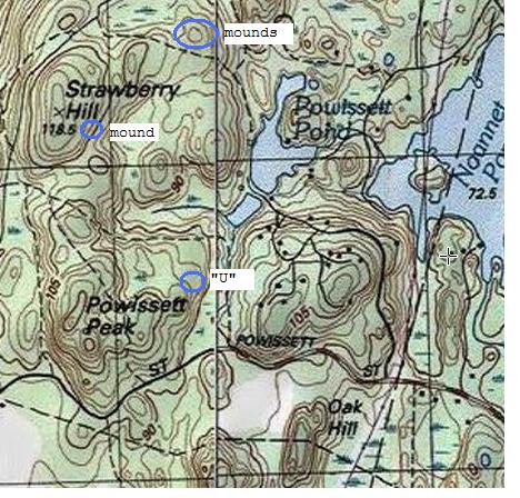
On the way back from the Powissett Mounds
Referring to the previous post.
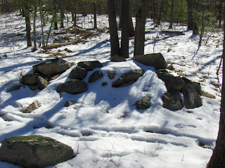
Usually I just stumble along in an area where I hope there will be rock piles. I look for undisturbed woods, I look for hill and water, but mostly I believe my discoveries are purely opportunistic. I find sites because I am persistent and vaguely systematic. But every once and a while, my little antennae tingle at the site of a familiar topography. I see something and say: that looks like a place I have found rock piles in the past.
For example, this pallisade of stone wall, carefully following the outcrops.

 I saw this on my right as I headed south along a trail. I do not think I have the place locate correctly on the map (of the previous post). Anyway, I have found rock piles on hills, in little flat areas surrounded by these sorts of "pallisades" and was telling myself: you really need to go take a look up there.
I am a lazy old man, more tired than usual because of the past several months of reduced activity, but forced myself to go take a look. There was one more rock pile up there, and I will take credit for some skill in addition to luck in finding it.

 There are lots of little curiosities in these woods:
 I am encouraged to go back again this next weekend. The snow should be gone and I can hope to find another nice site in there.
Usually I just stumble along in an area where I hope there will be rock piles. I look for undisturbed woods, I look for hill and water, but mostly I believe my discoveries are purely opportunistic. I find sites because I am persistent and vaguely systematic. But every once and a while, my little antennae tingle at the site of a familiar topography. I see something and say: that looks like a place I have found rock piles in the past.
For example, this pallisade of stone wall, carefully following the outcrops.


I am a lazy old man, more tired than usual because of the past several months of reduced activity, but forced myself to go take a look. There was one more rock pile up there, and I will take credit for some skill in addition to luck in finding it.


Powissett Mounds


Nearby, on the way out to the sky, was an interesting "gap" configuration:


After this, I poked around more and saw one thing after another.


Thursday, March 28, 2013
Stone Structures (Maine/Alaska)

"Over the course of the day we recorded and measured 18 stone structures. Many of them have a 2 meter diameter and are half a meter in height. A few of the structures have obvious courses and were finely made."
http://lacdor.blogspot.com/2011/06/hirundo-stone-structures.html
http://www.nps.gov/bela/blogs/Exploring-the-southeast.htm
Wednesday, March 27, 2013
A different kind of fragment
My wife is out of town so I had some spare time tonight, I decided to get out and try my luck at finding arrowheads. Bright overcast days like today was are the best for poring over the surface of the ground. It's tough this time of year to find anything so I went to a new spot I have never explored before. As happens more often than not, there was nothing to find there, not even a chip or flake, no sign Indians ever lived in this sandy place. With little time left before dark I drove to a farm field where I had found just a few broken arrowheads some years ago. It's a huge place and I have spent a lot of time there, walking for miles over every inch time and time again, and I have very little to show for it. With little chance of finding anything there, it sometimes feels like a waste of time to go there at all- but my hobby is really looking for stuff, not finding stuff. And in this place I can look all I want.
The sun went down, the last rays of light barely illuminated the earth. In such lighting only the quartz really stands out, I kept looking but had lost nearly all hope and was feeling desperate. I spotted a smooth gray object that looked artificial and picked it up. In my hand it had a smooth, waxy feel. I examined it closely and could hardly believe what I had found.
 This poor little broken fragment, this humble and unassuming bit of drab stone, certainly is not much to look at. But it is an important find for me, a first. The material is soapstone, also known as steatite. It is a fragment of a bowl or other vessel that was carved and used by Indians thousands of years ago. They valued soapstone because it could be shaped into things like bowls and pipes, and because it retains heat, making it useful for cooking. Soapstone outcrops are rare; the material for this bowl likely originated rather far from where I found this, it is (in my opinion) very likely the material was quarried from an outcrop in Rhode Island. This material is very soft and can be scratched with a fingernail, but the production of bowls from this stone using quartzite tools was difficult and time-consuming. It has some plow scars as you can see.


 I really like the clear tool marks on what would have been the inside of the vessel. It gives me goosebumps to think of these marks being made by a tool used by an early man, thousands of years ago. Soapstone bowls are associated with the Terminal Archaic period, 2,500-2,000 BP. It is believed that the discovery of soapstone might have been a major step in the transition from nomadic hunter-gatherers to a more sedentary way of life.

The sun went down, the last rays of light barely illuminated the earth. In such lighting only the quartz really stands out, I kept looking but had lost nearly all hope and was feeling desperate. I spotted a smooth gray object that looked artificial and picked it up. In my hand it had a smooth, waxy feel. I examined it closely and could hardly believe what I had found.


Tuesday, March 26, 2013
Buffalo Hunt Cairns

The "Placing" of Identity in Nomadic Societies:

by Michael C. Wilson
Douglas College in New Westminster, British Columbia

"Natural landscapes are appropriated, organized, and named by people, whose activities are localized to places and are thus transformed into cultural landscapes...Until recently, there had been few detailed studies of the cultural landscapes..."
 http://journals.hil.unb.ca/index.php/MCR/article/view/18057/21930

Indian Place Name data base
Vin of Menotomy Maps writes:
I’m working on something that might be of value to
your readers and they might be able to help expand on it.
It’s something I use because I’m always forgetting
what today’s names are for the Indian names I come across in older texts.
I put the names in a database. My idea is to share this
database and have others add to it.
Are these stone tools? From Greene Cty, NY
Reader Sara Sammon writes:
While out for a walk on our property ...Greene County NY ...we stopped at a known knapping station that we found years ago and each spring new flakes are visible.. Attached are what we found in the area... My question could the larger two stones be tools? working ax?


While out for a walk on our property ...Greene County NY ...we stopped at a known knapping station that we found years ago and each spring new flakes are visible.. Attached are what we found in the area... My question could the larger two stones be tools? working ax?


Sunday, March 24, 2013

By Hy-Crest Pond

But all and all, I think I'll keep the location of this mound to myself. It is pristine. You won't have trouble finding it if you look carefully. I saw this several years ago and thought the mound was only a few inches high - ignoring the obvious fact that it was sitting atop a larger artificial mound. Coming across it again, I took another look and saw that this is pretty much a typical "mound with hollow", except it is not rectangular and the hollow is not obvious.


In the past when I looked at this pile, I did not see anything nearby. Isolated piles lack context. But this time I noticed three things nearby. One was a small rock-on-rock, which I did not photo. But I was happily surprised to see something else in the bushes down at the water's edge. Never saw this before because I never came in winter:


I also noticed that the stone wall had an opening in it, next to the larger mound.


Subscribe to:
Posts
(
Atom
)