Wednesday, December 31, 2008

Rock piles at the foot of a ridge - Wolbach Farm Sudbury, MA

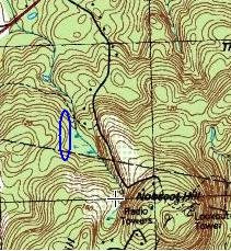
I wandered off the trail and got to the location of the smaller blue outline when I found rock piles on the side of the slope. Here is the slope looking southwest, there are several piles visible in the picture:For example:andThese are pretty smeared out. Here are two others:There were four to six piles in all. There was a stone wall a few yards to the northeast with a rock pile touching the wall:Here is a view back down the valley with the site to the right in juxtaposition with suburbia.
A last look at a smeared out pile:

Monday, December 29, 2008

Owl Rock at Spring Lot - from FFC


FFC writes:
the water is high for this time of year. this break out zone is particularly fraught with ceremonial activity possibly because of the dramatic hydrology relativly close to the top of the hill. evidence of unusually numerous lightning strikes related to the high water table close to the top of the hill seem to have created a reverence for the nature of the location judging by the oral traditions and physical remenants of ceremonial activity in the area. ffc

Thursday, December 25, 2008

Happy Holidays!

A lovely photo of a frozen cairn on Mt. Kinsman.

Monday, December 22, 2008

Off to vacation

Going to CA for a few days.

Early Morning at the Wolbach Farm - Sudbury MA

On the topo map, I noticed a patch of green I had not explored before. Right south of King PhilipsWoods [click here, the oldest post at the bottom is most comprehensive] and, being part of the Sudbury Valley Trustees land, this seemed like a good place to go for a Saturday walk. I parked at the visitors parking and headed uphill behind the shed. I saw rock piles immediately but this did not surprise me as the area is part of a slope (the larger blue outline) that is covered with rock piles at a low density.

It was nice to look at new rock piles:[detail:]There were lots of examples of piles built into the outcrops. And this reminded me of several other places. Trying to recall where else I have seen this kind of "enhanced outcrops" what came to mind first were other sites close to hand. The King Philips Woods has enhanced outcrops and so does the Town Forest at the corner of Subdury, Farmingham, and Marlborough. I did not get good pictures.

There were some small oval ground piles:There were some sketchy stone walls, perhaps alignments. Here was a little high point...... with two rows of stones leading away:Someone preparing to build a more substantial stone wall? Apparently it was all Indians living in here through the Colonial period.

Perhaps the most interesting thing, to me, was a small rectangular pile on a saddle looking eastward.This is early December and you can judge for yourself what might be viewed from the location and in this direction. Another view: Looking at the flat rock on edge, in the foreground of the last picture, I had a stray thought that it was like a shield reflecting the light. This led to my looking more closely at the rectangle and concluding that it was really more 3/4 of a rectangle and the front edge (upper left in this last picture) was missing. Actually this could have been a rectangular "U" that has been filled in like a rock pile. If so then it would have been a viewing station.

Maybe it was, maybe it wasn't; but thinking about it led to a question: what would be the purpose of a stone "U"? We have a loose idea that stone "U"s are built as part of a prayer seat, a location for visions or, in this case, a place to look out at the sunrise. But what do you need a "U" for, when all you need to do is sit? An answer is suggested along the lines of that flat rock providing a "shield". Perhaps the purpose of the "U" structure was to shield the person on the inside from something in all directions except the viewing direction.

Rock pile visible from Rt 20 Sudbury, MA

This is visible on the south side of the road a little east of the Framingham line: I always get a small thrill to see something still there, although crowded to the side by the bustle of modern development. Spotting this from the car, I parked behind a retirement community ["Orchard" something] to hop out and get the picture.

Near Nobscott Hill - Subdury/Framingham MA

I have not had much luck exploring around Nobscott Hill but there are plenty of little nooks scattered around on this large hill and I have heard that there are rock piles somewhere in there. So I keep exploring there, a bit at a time. I had some small luck several weeks ago when I went down into a valley to the northeast after circling the top of the hill. Along most brooks in Massachusetts there are traces of fallen down structures, often old dams and mill works. I am often uncertain if I am looking at something ceremonial or something mill related and this was the case when I came across a tumbled down rock pile at the edge of a wetland. I took a couple of pictures as this was the first potentially interesting rock pile I found in several weekends of looking.Nearby the hillside was dug out like a sand or gravel borrow pit and these stones might have been discards from that operation. Except that they were all comparable in size and not lying at an "angle of repose". So perhaps this was ceremonial or, next to the brook, perhaps something related to a mill. Also this was an isolated rock pile and I tell myself to always be suspicious of isolated piles. We do not really have ceremonial rock piles so much as ceremonial sites containing rock piles. At first glance, here, there was no such site.

But I continued downstream and, a few yards later, came across another similarly situated pile:
Again there is an uncertainty about this pile but, if you look in the background, you can see something else. Here are a couple of pictures of a structure consisting of rocks on top of a split rock, with a tree growing up in the split: Nothing mill-like about that. So I looked around some more nearby and came across another structure having nothing to do with mill operations or gravel pits - seemingly a ceremonial structure:Here is a not-too-good view of the site with the last pile to the far left, the split rock three quarters of the way to the right and that initial pile to the far right.The wetland and brook are beyond the stone wall. In the end I concluded this was a ceremonial site. But there were other other tumbled down strctures that really did not look like rock piles, so I am still not sure.

Sunday, December 21, 2008

Remember the fall?

With the snow now thick outside my window, I am browsing old picture files looking to see what space I can free up on my hard drive. These two large rock-on-rock examples from Bolton, along the edge of a wetland/brook:
remind me of some other large rock-on-rocks that I saw last weekend along a brook on Mt Pisgah, Berlin:I wonder if there is significance to the large size of the upper rocks?

Tuesday, December 16, 2008

Well in a wetland - Concord

There is a water break-out zone to the left of Sudbury Rd on the far side of the river as you head south and start to go uphill. I went in there to have a look and found a well that was actively emptying from recent rain. The structure was a rectangle of dry stone without mortar several feet above ground level.
Let's get a bit of color into the photo [click it to enlarge]:I read somewhere in an Ernest Seton Thompson book about "Indian wells" where Indians would get water at the edge of a swamp by digging a hole into the moist soil. The hole would rapidly fill in with sludge which would get emptied out. It would again fill with sludge and again get emptied. Each time the sludge would come in a little clearer until it was clear drinkable water. When we were kids we found a rectangular stone lined hole in a swamp next to Rt 2 in Lexington (now the first office building east of the 128 exit North) and later I wondered if that was an Indian well. So now I wonder about this structure from Concord. It would be nice to know something about it.

Rocks sitting on their haunches

FFC wants to know if anyone else has noticed this kind of rock structure?
Here is another one:
FFC asks what is this? Has anyone else noticed it? It seems to be looking up in the sky, what direction? [He measured one facing ~25 degrees magnetic.]

Sunday, December 14, 2008

Apologies for not blogging

I have been multiply distracted lately from posting. New sites are harder and harder to find but I found a few this weekend and hope to find the time to describe them over the holidays.

Friday, December 12, 2008

Swedish perched boulders

From Norman Muller:
A Swedish researcher I have been in touch with, Bo Westling, has a website devoted to perched and pedestaled boulders at: www.bowestling.se. It is all in Swedish, unfortunately, but the photos are self explanatory.

Wednesday, December 10, 2008

Nobscott Hill, Sudbury/Framingham

This is the largest hill around. Today it is crowned with radio towers but not long ago it was central to the Native Americans. I am told there are rock piles somewhere here but it is a big hill and, so far, when I've explored it all I found was empty oak forest with no undergrowth and few signs of anything - an occasional stone wall. One exception from last weekend, was this little line of rocks near the summit. It seemed impractical to and old.

Pet Memorial at Nobscott Hill, Sudbury/Framingham

With a fine view to the south:
Not sure if I am intruding. This was the only prominent rock pile on the hill.

Closeups, suggest a cat:

Tuesday, December 09, 2008

Indiana History - rock piles as a warning?

If you watch this, they mention rock piles after a moment or two. Never saw this idea before, kinda weird and presumably fictional: [Click here]

Weird Pennsylvania by Matt Lake, Mark Moran, Mark Sceurman

Some nice accounts and photos of rock piles. [Click here]

Rock pile poem

Not sure where this is from [click here]

Rock piles for "pikiavish"

A magnificent stone "U" from a collection of California Ethnographic Field photographs. [Click here]

The Megaliths on Apsheron Peninsula

[Not rock pile related but rock related]
Some interesting stuff. [Click here] "From the Window to Baku". Not from America, I am not sure where Baku is. Wikipedia tells me it is the largest port in Azerbaijan. Not sure where that is either. Wiki says east of the Caspian.

Stone Mounds - from Mysterious Ancient America by Paul Devreax

[Click here]
Has anyone read this book? He mentions rock pile research in the 1970's that I wasn't aware of, or forget.

Monday, December 08, 2008

Time for bright orange clothing

One of the hazards of this hobby, like ticks.

The Nipsachuk story - up to date

Since there has been some recent new interest in the Nipsachuk story, here is the full collection of articles.
[Click here (oldest stories at the bottom)]

Stone chamber - Sharon MA

Via a reader:
The following are some recent photos in Sharon, Mass that I have taken.
They are posted on my photoblog, Beeps and Chirps.

http://www.beepsandchirps.com/index.php?showimage=377
http://www.beepsandchirps.com/index.php?showimage=375
http://www.beepsandchirps.com/index.php?showimage=376

Visit the blog BeepsAndChirps [Click here]

Sunday, December 07, 2008

More details about Nipsachuk

[Click here] from the Valley Breeze (link via Norman Muller).

One sees certain names mentioned.

Some photos and text from the Berkshire Woods

Carved stone [Click here]
Standing stones [Click here] and scroll down.

from the "Mossy Skull" ([Click here] for the home page)

Friday, December 05, 2008

Projo.com - The Providence Journal gives a Nipshachuk update

[Click here] The continuing drama.

Some small rock pile sites near Golden Run Rd - Bolton/Harvard

Walking around, a couple of centimeters down the map from the highway swamp [click here]. There are numerous little hints, several good examples of field clearing piles (along the white-color/green-color boundaries on the map), and I did eventually find a small organized site along that larger brook, where some beavers have been at work:
The bulldozers are only a few feet away.

See the brook begin to flow

East of Golden Run Rd Bolton/Harvard, downhill, is a very pretty little woods and wetland breakout zone.

See the twins and the large split rock behind?
Closeup of the rock. This does not seem like an organized totality of ceremonial structures. More the occasional celebration of the natural features of the place. In the words of the poet: Look upon the landscape here:

Hollows on the hillside

I was out looking for rock piles on what turned out to be a big sandy hill in Natick. Saw some nice graffiti on a water tower at the top but few rocks of any kind. I did notice, in a couple of places, hollows dug into the sandy soil. Finally, after seeing just one more of them, I decided these might be worth mentioning. I do not know if Anglos would dig isolated holes like this on the hillside. Indians did, to store grain.