Monday, December 25, 2006

Robbins Hill, Chelmsford MA

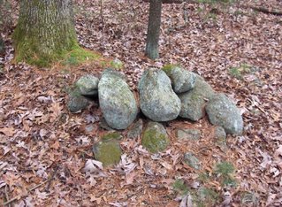
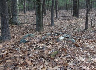
The tallest hill in Chelmsford is Robbins Hill and it's southwestern slope is covered with old broken down rock piles. Most seem to be made with burnt rock, suggesting to me there were lots of fire up here sometime in the past. Why make this site public? Well it is old and already badly broken down. Some kind of paintball/scout activity has re-used the piles for little jumps and little fireplaces so I cannot see much hard in mentioning it. I do not think these are burials, for several reasons, and the worst that could happen is somebody could go up there and kick some of the rocks around.

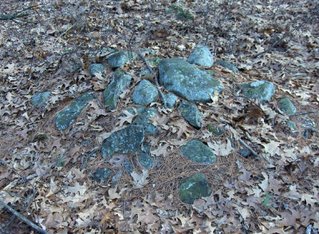
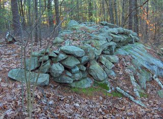
There are small piles which, in some cases, are lined up with each other - three in a row along a line. They look like this:
Note the quartz in front of this last one.

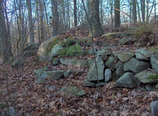
There are also some larger "platform" piles:Consider these features:
  • ground piles in lines
  • occasional use of quartz
  • some larger platforms
  • signs of burnt rock
  • on a slope
These types of characteristics are what I call "marker pile" site characteristics. So, if you live nearby and want to see what I mean, go drive up Summit Rd, up the dirt part to where the road tops out and forks. Park there and walk south downhill.

Merry Christmas

Enjoy the return of the sun.

Friday, December 22, 2006

Other views of the Tyngsboro 'mill' site

These views are from the site I reported earlier this week [Click here]. The "main pile" I discussed there is to the left in the first picture looking downward. It is in the center in the second picture looking back upward.

Thursday, December 21, 2006

Expect light posting through Christmas

Actually with the free time of Christmas vacation, perhaps there will be lots of fun stuff and the time to report on it. Let's hope so. But for the next couple of days I do not expect to post much.

If you, the reader, have some pictures you could share, this would be a great time to send them in to rockpilesmail@gmail.com

Wednesday, December 20, 2006

The Desert - Marlborough

Driving home from Mt. Ward I passed Marlborough State Forest and an entrance marked "The Desert" - which I had read about online as a conservation land comprised of sandy glacial soil, little disturbed since earlier times. I assumed that sandy soil was not a place to look for rock piles but as I drove by on State Forest Rd (or something like that) I saw a couple. Here is a detail of the near pile: When I parked, I ended up walking for twenty minutes up and down little knolls of bedrock outcrops, as it turned out. Several of the outcrops looked like rock piles but I decided they were probably just frost broken bedrock. Then I saw some that were definately deliberate rock piles because the cobbles were not all of the same material as the bedrock. What is in these woods seems too fragmentary to get much of a feel for what is going on but there was something here. It would be worth exploring more systematically - when I am not on my way home from an earlier walk.

Mt. Ward - Marlborough

Mount Ward is a small hill near the Boston Post Rd in Marlborough, MA. It is sure to have been a popular destination for hikers and picnic'ers over the years and I only went there because the hill I wanted to explore was in-accessible. But I wanted to head more in the direction of Marlborough anyway because that is the nearest place to the southwest of here which I have not yet explored. It is getting hard to find an un-explored woods less than 1/2 hour drive from home.

This was at the top of the hill:
So you would figure there would not be much left on this hill. In fact this little item could be a fire ring or a used prayer seat. The lack of charring on the rocks and the rocks in the middle of the circle argue against this being a fire circle. Also building a small campfire on the top of the hill - in the most windy place - does not make a lot of sense. So I vote for prayer seat. The rocks in the center of the circle indicate [I am guessing] the proper completion of the ceremony. Without the recent trees this would have been a fine place to look out.

Here is a bit more of the background.
That is all I saw at Mt. Ward.

Tuesday, December 19, 2006

Another lobe of a favorite site in Tyngsboro

As I was driving along, approaching this little pond on the right I noticed a lot of stone work to my right and stopped to take a look. Eventually I found some great piles but before I even walked in there I noticed something interesting on the other, downhill, side of the road. Someone build some little staircases down from the road and from the adjoining property, leading down to the brook that flows off downhill there. I am convinced there was some kind of mill in this area because there was also a trench diagonally off to the side of the brookA few feet below these steps was a trench that looked like a mill race. If this wasn't private property with parking obviously in-appropriate, I would like to sneak down this brook to see how it fits with the major site below. There must be more piles along the brook.
Anyway I went back to the up-hill side of the road and took some quick pictures. I was made nervous by my camera being more and more broken - this time I could not turn off the flash. At the same time I was nervous to be easily visible from the road and also on private property. So I took a picture or two and started to sense something larger looming in the distance, which you see faintly on the upper right of this panorama. For reference, here the brook is to the left and the open space beyond corresponds to the little pond in there.
So I rushed around taking pictures. First here is that large pile seen from different sides:
And here is a view down towards piles below:
Notice the brook at the bottom. The pond is to the right in this photo. So from this knoll we have a fine view out to the southwest and a nice view out to the west across the little pond.

There also numerous piles along the brook but most were decrepit. Here is a nice one:
In this picture, we are looking back towards the road with the brook to the right.

On the other side of the brook the ground rises slightly, as is not shown on the topo fragment, and there are a few piles over there which I saw before - I think it was last winter I dragged Barb and Joe on a hike up here and stopped briefly to get pics of these piles. I was impressed, at the time, with this pile wrapped around a boulder:
I also photo'ed a pile in the middle of the brook. It was in line with a stone wall coming downhill and I was wondering about dams and mills. There were several stone and dirt walls running down to the brook and there were lots of destroyed structures which could have been piles or something else. It is a very complicated collection of structures in there with what I would guess is a complex history. Some of the piles look pretty new and also those steps look pretty new. But there are lots of broken down things all around as well. Then how about this: last winter I thought I saw a rock pile on a cement culvert. This time I wanted to make sure so I climbed on the stone wall leading over to it and got this picture:
So what the heck is up with that? I get a feeling of someone recently fooling around with these rocks. This cannot be more than about 50 years old. I suspect the wonderful pile-gap-pile site downstream aways is built by the same more recent person. So my final guess: an old broken down mill with a modern Indian re-using the stones for piles. The site might have been ceremonial before and after the mill. The ceremonial mixed with the profane.

If you go downstream from this site there is another very nicely preserved site. This makes it likely the area has recently built structures.

Links From Russian Geographical Society, Saint-Petersburg

by JimPJames Gage received an e-mail from a gentleman named Vyacheslav Mizin of the Russian Geographical Society, Saint-Petersburg. He sent James some links with many photos of lithic sites in Iceland, Lapland, Siberia and a few other places. James sent those links along to me for posting here.
WARNING: Most of these pages will take several minutes to load, but they are very much worth the wait.

A couple of the pages are in Russian, and for those the following handy online translator will translate the entire page into English for you (the translations are not perfect by any means, but it works well enough to give you an idea of the content):
http://www.online-translator.com/srvurl.asp?lang=en

Here are the links:
(Iceland - in Russian):
http://www.perpettum.narod.ru/icelandstones.htm
(Lapland - in English):
http://www.perpettum.narod.ru/summary.htm
(Lapland - in English):
http://www.perpettum.narod.ru/arcticmegalith.htm
(Arctic Regions - in Russian):
http://www.perpettum.narod.ru/seid-2.htm
(Various - in English):
http://www.catshaman.com/261mon/0Cultural.htm

Monday, December 18, 2006

Circular Trenches

This is the third example of a circular trench. Maybe 30 feet or so across. These are from Far southeastern Tyngsborough, just up from Westford, east of the Massapaug watershed. The other two I wrote about here [Click here]. This one was only a few feet away:

An open spot in the woods

When there is no underbrush under the pine trees you think it is the trees dripping their bitter resin into the soil and killing things off. In a natural setting, there ought to be something under the trees - blueberries, or lillies of the valley, or some kind of underbrush. I was at one place in the woods this weekend in a space that was twenty yards wide and forty long where there were no pine trees and no underbrush either. It was not a bald spot, just a place where only grass and moss were growing. In places like that you get a feeling that a lot of people have walked there and tamped down ("compactified") the soil and I created a whole fantasy about this spot in the woods.

First off, I was walking along with minor knolls and level spots, along the side of a wet breakout zone. I saw one rock pile, exactly on top of a knoll, looking out but not much more. Than I saw the first of several circular trenches of varying depths: a foot or two deep.
In this picture the outline is perhaps 35 feet across. I looked at it and tried make sure it was real and tried to imagine why there would be such a thing here. In some places the trench was a little deeper than others - the right hand side in this picture. Then I saw another:
Again, some parts of the outline are deeper than others. In both cases, the "mound" inside the trench is little above ground level and suggests rather a bit of the dirt from the trench being tossed up. But what could be the purpose of such an outline? I was thinking it might be a longhouse or a wigwam outline - but of course I have no idea what that would look like. Finally, this spot was nestled just east of a steep little hill. Later I found a third outline and tried to get it on video (I'll put this in a separate post).

I climbed to the hilltop and then down the western side. Just a few feet down, actually not more than 60 yards from the outlines, was a level bare spot with grass and moss. On each side, facing each other across the space were remnant rock piles.
The bare spot seemed naturally to be a place where people could gather or -at least- walk around enough to tamp down the soil. So that is the fantasy. Three circular outlines for dwelling places and a level spot for dancing. It might be fun to excavate a place like this.

Link to Wyoming Rock Piles

Sent in by Bruce McAleer. I think we have linked to this before but it is worth looking at again.
[Click here]

Photos from the USGS

by JimP
All of the following photos were found in the Photographic Library of the United States Geological Survey.

The first photo was taken in 1919 at San Bernadino, CA on a low ridge south of Crucero Hills in "Mormon Pass". According to the USGS these piles are assumed to have been made by Indians but their significance is not known.The next photo is called the, "Mystic Maze." It was taken in 1917 in San Bernadino County, CA. According to the USGS the photo depicts, "Piles of stone raked into rows by early Indians, which intersect at various angles. Said to have been used in death rites by tribes older than the present ones."The next photo was taken in 1926 at Craters of the Moon National Monument, Idaho. According to the USGS, the photo shows, "Crescentric piles of rocks which weighted down Indian tepees."The next photo was taken circa 1960 at Death Valley National Park, CA. The photo's caption reads, "The near end of this alignment, which covers half an acre, resembles the head and coils of a serpent. At the far end is an oval mound of rock."The next photo was taken in 1916 at Rocky Mountain National Park in Colorado, and shows a cairn said to mark the trail on Flattop.The following photo, taken in 1914, shows a topographer at work near a cairn in Southwestern Alaska.The next photograph, from 1909, shows what's labeled as a, "sheepherder's sandstone monument," in Cascade County, Montana.The following photograph is from 1889 and shows a stone heap in a field near Lake Ontario in New York State.Finally, this last photograph was taken in 1907 three miles ESE of Dana, MA in Worcester County -- Dana, MA was disincorporated in 1938 and some of it now lies at the bottom of the Quabbin Reservoir. There are only stone walls in the photo, but I thought it was an excellent reminder of what the land in Massachusetts once looked like.[Click here] to search the online Photographic Library of the United States Geological Survey.

Sunday, December 17, 2006

Modern cairn from YouTube

Kind of grand withall:

Solstice viewing in Carlisle

This is from the Carlisle "Mosquito", a local newspaper. Check out the letter to the editor by Tim Fohl [Click here]

Saturday, December 16, 2006

Friday, December 15, 2006

Old sacred videos by FFC

Video clips of "spirit doors" by FFC [Click here]
If you haven't watched them recently, they are worth watching again.

An effigy?

This is from Larry Harrop: [Click here]

Any ideas about what this might represent?

Thursday, December 14, 2006

Those @#$!@*&#$^ Andover Woods

Here is a map fragment from where Rt133 crosses Rt495 on the Andover/ Tewksbury border. In the map, Rt 133 is a horizontal line and Rt 495 is a diagonal. There was a little piece of un- explored woods in the sector on the right, north of Rt133 and south of Rt495. Now, just for fun, if I told you there was a rock pile site in there, where would you look if you tried to find it? I leave this as an exercise for the reader. The answer is at the bottom.

It was a slow weekend rockpile-wise and I wanted to try to locate something during lunch break, so I drove away from work, a couple of exits down, and parked behind a Longhorn Steakhouse at the road corners, and walked east into the woods. The woods are so trashed out and it seems to be that way in most parts of the woods - there in Andover. I cut across the woodland one way and planned to stop at the obvious place on the way back and was grumbling to myself about how badly used were these woods and how I wasn't going to waste time going out again to explore these darn Andover woods. There were cart roads, trenches, places where bulldozers or some other process pushed up banks of dirt. There were pot-holes, percolation test pits, and natural hollows filled with water. And as I came back via the obvious place, sure enough and right on schedule was what looked a lot like a rock pile.
Here is another view:I was pretty surprised, since I had just been thinking how lost these woods were. Yet isn't it amazing how these little inconspicuous Native American ceremonial structures have managed to survive? There were six in all. If there had been only one I would have discounted it.

Here are some others:

They appear un-disturbed in spite of what was going on around them in the woods. All just a few feet away from this little pond.
So that should confirm your guess about where the piles would be located (if there were any). I should also mention the impression that each of these piles had an upright flake or "fin" and perhaps one other prominent rock - either pointed or larger than the rest. I did not pay enough attention to the way the "fin" was oriented.

By the way, that first brook to the west of the little pond was explored on the northern side of Rt 495. In fact there is a site over there closer to the headwaters of that brook.

For Ernest Seton Thompson fans

Not rock pile related but this blog got a link from here: [Click here] It is a blog about Ernest Seton Thompson - one of America's great naturalists.

Wednesday, December 13, 2006

About Rock Pile Effigies in the Concord Area - April 2001 Journal

I still believe some of what I wrote here:

Several years ago I found a rock pile on a boulder that suggested the shape of a female sitting cross-legged. Later a friend found a second example, of almost identical design, and I started taking seriously the idea that the Indians might have deliberately constructed rock pile effigies - that these might not be just a figment of my imagination. Here, I want to set the stage for a gallery of photos I have been collecting, so the reader can judge for themselves. In the course of the last year, finding between fifty and one hundred of these "pictorial" rock piles, I have come to believe they are examples of representational art that were part of a ceremonial tradition of the New England Indians. In particular these rock piles are always found near a source of water, such as a seasonal spring or a vernal pool, they tend to be oriented in particular compass directions that are consistent with what is pictured (for example female figures usually face the Southeast), they usually occur in groups, and they usually are found near other anomalous rock constructions such as split-rocks filled with cobbles, rocking stones, and perched rocks.

In the Concord area there are many different kinds of rock piles. Traditionally these are viewed as field clearing piles, or as manuring piles for enriching the soil. To consider rock piles as all the same, all belonging to one (or at most two) categories is an oversimplification. A brief survey (Waksman, Neara Journal Summer 1999) finds that some piles are tossed together, others well constructed. Some are made from glacial till, others from broken ledgerock. Some lie at the angle of repose, others are domed, and others are flat. Some occur in isolation on high ground, others occur in groups at the edges of swamps. Given this variety, "rock piles" should not be considered as a single type of construction, and generalizations should be avoided.

The rock piles I am talking about consist of a single layer of cobbles lying in a horizontal plane on top of a larger support boulder. The piles usually have an axis of symmetry with one prominent round cobble at the top of the axis. The individual cobbles have diameters in the range of six to twelve inches. Since these piles are delicate, they are often damaged with their cobble positions jumbled. So finding one in perfect condition is rare.

Certain facts support the idea that these effigies are a reality, and the reader is urged to go out and see for themselves. These facts are: correlation with water, standard designs, correlation with direction and view of the landscape, clustering and localization of the piles, and the use of particular colored cobbles. These features are non-random and support the idea that these rock piles are special, curious, and definately not related to pragmatic use. Some of them are even beautiful in their simplicity, which qualifies them to as art.

Correlation with Water
There is a strong correlation between springs (places where water comes out of the ground - possibly seasonally) and such rock piles. When a rock pile is found in a location far from water, it does not conform to this description - usually consisting of several layers, with no axis of symmetry and no shape. Conversely, when a spring is examined, in an out-of-the-way part of Concord/Carlisle/Acton/Stowe/Lincoln, in most cases you will find a cluster of exactly these types of rock piles, overlooking the source of the water.

Clearly there are many springs in the midst of modern construction, and failing to find effigies at a spring should not be surprising. But in the middle of deep woods where there is a spring, this author is surprised if no low rock piles occur. When this happens, I find either that there is no good view of the horizon or else there are telltale traces of some past logging or gravel operation nearby. What this suggests is that every spring had its rock piles, every source of water was an oportunity for ceremonial contruction - something hard to accept.

Standard Designs
Certain designs occur repeatedly and have specific characteristics. For example:

Woman:
Man:Turtle:
The most characteristic features of the "Female" is the W-shaped rock for the breasts and the flat pedestal at the bottom. A variation is for the breasts to be formed from two similar sized cobbles. The most characteristic feature of the "Male" is the horizontal crossbar, which is sometimes formed with a row of similar sized cobbles. The most characteristic features of the "Turtle" are a larger domed boulder, with a small shelf close to the ground and a single slightly pointed (beaked) rock resting on the shelf. Some slightly less expected rock pile designs are seen repeatedly:

Bird:
Twins:
Crystal:
The most characteristic features of the "Bird" are the slightly pointed head, the elongated symmetric placed wings and the trapezoid shaped tail. The characteristic of a "Twins" pile is the two curious "boat rudder"-shaped rocks next to each other. The characteristic feature of a "Crystal" rock pile is a central rock with unusual color or crystals, ensconsed symmetrically by other rocks.

There are also miscellaneous other designs which suggest a particular species or have a noticeable symmetry. But these above are reasonably common, as shown in the photos below.

Correlation with Direction and View
The axis of symmetry, in the direction from the prominent "head" cobble usually points in a particular direction that is specific to the particular design. Also most piles are located with a view out over the water (or swamp) and there is some corelation between this direction of view and the design. This is not a perfect correlation but is reasonably strong. In particular "females" typically face to the Southeast; "males" typically face to the West; "turtles" and "birds" typically have their head to the Northwest.

Clustering and Localization
These rock piles usually occur in groups of between five to twenty piles. With a couple of exceptions they do not occur in isolation. The groups, as already noted, are always localized to places where there is a view of a nearby water source. It seems clear that such clustering and localization is not random and my friends and I are preparing a density distribution map which will show this clearly.

Use of Colored Cobbles
Most cobbles around here become grey with lichen after exposure to the air for several years. Some rocks do not support good lichen growth and retain a natural coloring. These include black rocks, white rocks (such as quartz and feldspar), brown quartzite, and iron-rich red rocks. Possibly these colors are being used deliberately. It is common to find a black rock juxtaposed and paired with a white rock, across the axis of symmetry. Something like this: