Thursday, March 11, 2010

"Walden Woods" off Rt 85 - Milford, MA

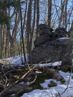
With me driving and FFC spotting for rock piles out the window, we drove north on Rt85 through Milford and, later, into Hopkinton. (Rt85, or Cedar Road, is the main road running vertically through the map fragment above.) Some time ago I was shown some pretty vast sites in the area by Bruce McAleer and I figured there was more to be seen and was particularly interested in the areas around Echo Lake. For the most part, since Echo Lake is a water supply reservoir, parking anywhere nearby is prohibited but at one point a modern development showed up on the left (the road going left from 85 at the letter "C" in "Cedar") and we ducked in there, ignoring the "Private Road" signs. We could both see a pretty interesting hillside just north of that road at the entrance (see here), and FFC spotted a rock pile. So we pulled over and went to have a look. Here is the scene up there:
There were signs of more recent quarrying:And a number of rock piles that could have been modern or ancient.
and some obvious mixings:
In the first picture above, there is a large rock pile at the rear, to the right. Here are some closeups:This is what I have been calling a rectangular chambered cairn, presumably vandalized. Note its position at an outlook. Recall that chambered cairns like this, at an outlook, are one of the characteristics of the "Wachusett Tradition". I did not see any "ski jump" shaped piles here but there were several nice rock scatters on top of boulders with some hints of vertical facing:
(I think it takes quite a while to grow that kind of moss)

Also:
There were quite a few nice piles scattered from the bottom of the hill to the outcrops at the top.

Here was something quite interesting at the top of one outcrop. This is enough like a serpent effigy that I want to call it that:


Also some nice split rocks - one that is split and filled:One that is wedged with a single wedge:

When we got back to the car, the custodian of the private development had wandered out, coffee mug in hand, to chase off the riff-raff. We chatted and left with a slight sour taste in the mouth. I was thinking that since the development bulldozers left off exactly half-way through a good sized rock pile, we probably could have given him a hard time, in a NAGPRA sort of way.
(the bulldozed slope is to the right). But then, mucking up the rock piles here was going on long before the modern housing development.

Preview

Wednesday, March 10, 2010

A hard-working stone wall

I was impressed that this wall was making such an effort to get the "job" done - whatever that job is.

Bally Brook Hill - Sterling MA

You can probably figure out where this hill is in Sterling. Some time ago I risked getting shot by exploring behind a "rod and gun" club and located an interesting rock pile site where features seemed to be visible from a central boulder. That is somewhere near the lower blue outline in the above map frament. Last weekend I went out to explore some of the same area but in spite of a couple of weeks of above freezing weather, I managed to find a place where I was sinking 1/2 foot deep into the remaining snow. So I did not explore as much as I wanted to - tiring quickly. So I was post-holing up the hill from the east, and only going to the top out of a sense of duty, when I paused to catch my wind and spotted a rock on rock:
and nearby, a few rocks on a rock. I then crossed a stone wall into a several acre area enclosed in a quadrangle of stone walls, and spotted a few other items poking through the snow:It might be worth re-visiting in the summer, to see if more structures are visible.I was trying to focus on the interesting rock material:
andAgain, there is probably more there than is visible at this time of year.If you ever get out there, try to locate that place down at the southeast edge of the hill. I was not sure of its exact location but I think the location of the site described above is correct because I found the old road leading up the hill in the right place.

Looking southwest over Sterling

You get nice views from under the power lines.

The Last Mammoth: Lewis and Clark’s Secret Mission

By Tim Deatrick and Jaime Babbitt


1781, a tooth sent to Thomas Jefferson by General George Rogers Clark from Big Bone Lick, Kentucky was the beginning of what has been described as “the greatest camping trip of all time,” the manifest destiny of a fledgling nation; but to the Native Americans who lived along the rivers, plains and mountains of the Lewis and Clark “Corps of Discovery” trail, it was an unprovoked invasion. It was a mammoth hunt that forever changed the native way of life.


 "Native Americans have a specific way of revealing their historical knowledge. Their oral stories are often embellished with interactions between historical events and supernatural beings. In 1762, the Shawnee told John Wright about the big stone skeletons found along the Ohio River. They said the bones belonged to an immense animal, the "father of all buffalo," which had been hunted by "great and strong men" of the distant past. But the Great Spirit destroyed the huge animals with lightning. The Delaware elders told Thomas Jefferson a similar story; only they claimed that the gigantic animals were driving away smaller game, like deer and bear. This angered their god, who blasted the great beasts with lightning. Only their petrified bones were left, although some thought that the huge animals escaped to the far north..."
Full text: "Last Mammoth"

Tuesday, March 09, 2010

More mounds with retaining walls

In reference to the previous post (click here), Norman Muller writes:

The mound with retaining wall in the attached photo is at large cairn site in Rochester, VT. The mound itself consists of small fist-sized stones, and can be favorably compared with the first photo from Ted Hedrickson in your recent blog entry.[PWAX writing:] Some other examples from one site in Carlisle, MA:There are two other examples from Carlisle I know of but I cannot find the pics. Found this one from Stowe MA, while looking:It is interesting seeing these examples side by side. For example, Norman was calling attention to the large rocks outside the retaining wall on Ted's photos, similar to the 2nd Carlisle photo above.

"Sunday" a new site from Ted Hedrickson

Ted H. sent this. I think this is a site in CT:

We were out Sunday, intrigued by a map from a local land conservancy that was dotted with "rock pile" labels. The land was strewn with walls, at several intersections were large piles connected to the walls, sometimes where three walls came together. There was a small foundation and two wells, showing colonial era habitation. Near the edge of the property were found this large mound unconnected to a wall:

see moundN and moundS shot from opposite sides
Shot from the north and south you can see the built retaining walls on parts of this roughly circular form, 8-10 ft high at center. Nearby was an area of concentrated smaller piles, some on the ground and some on rocks.

Continuing on, this pile was built on bedrock and unconnected to walls:

see DSC03090 from northeast andDSC03092 from southwest
I guess they could be clearing piles. We thought they were pretty cool. What do you think?

"Why and how Native Americans Built Mounds"

From examiner.com this article [click here]. Note the absence of any mention of astronomy. Also, I stopped reading before seeing any reference to the Central American cultures that were part of the same socio-ecomonic world as the Mississippian mound builders.

Enderslie Preserve Woodbridge CT

Enderslie Preserve Woodbridge CT

Monday, March 08, 2010

Rock Piles in GA

Norman Muller sent this link http://thesga.org/tag/rock-piles/
[There is plenty of digging and dating, but do not hold you breath: no solid conclusions]

As I read the linked to pdf (you can click on it from within the above link) where the author reviews a large number of wonderful sites and concludes they are not from field clearing but rather from temporary staging for later sale of rocks, I am disappointed. It is largely an exercise in assumptions.

Saturday, March 06, 2010

Rockpile Mountain Wilderness

"The state's smallest Wilderness area,
Rockpile Mtn. Wilderness (Missouri)...Its name comes from a mountain in the area that sets the stage for an ancient circular pile of granite erected by some long-forgotten inhabitant..."

Thursday, March 04, 2010

curious about a visitor's search terms

A Google user found this site today, searching on the phrase "why did early americans pile rocks on garbage pits".

Makes me wonder: where the heck did they get that idea? Anyone know?

Revisiting a marker pile site in Bolton

Several years ago, Bruce McAleer and I explored south of Rt 117 and East of Rt 495 in the patch of woods between Camp Resolute and those highways. We saw a minor rock pile site and I realized, recently, it might be worth exploring a bit further south. Heading out, I passed through the familiar territory on the way to the new. I think you can actually glimpse some of the piles in this site, on the right, as you head north on Rt 495 just before the 117 exit. Anyway, the site is nicer than I remembered. Here is the approach with a boulder at the upper left: [Note the path/old road in the foreground].

Taking a look at that boulder (facing back the way I came in) , it is adjacent and parallel to a long thin pile:
A nice little structure I do not remember from the previous visit.

There were a number of nice little piles in the snow, probably damaged and a bit smeared out: Several un-damaged vertical sided piles: Piles in lines, and evenly spaced:These characteristics of vertical sided piles, in lines, are what I call "marker piles". Another characteristic I see occasionally at such sites is one pile at the edge - possibly at the end of one of the lines of pile - with a nice chunk of quartz in the center. I found that kind of pile here: Closer:[For those who appreciate the turtle, lets look even closer:] A pretty piece of quartz, maybe even deliberately shaped.

Roadside attraction - Tewksbury split boulder from Rt 495

I noticed a split boulder (next to the highway) with a wide gap and three blocks of stone, with even spaces in between, placed so as to span the gap. Check it out: if you are driving north on Rt 495 and have passed the Rt 38 exit to Tewksbury then this rock is on the right before the Trull Rd overpass. I have been glancing at this rock, in passing, for years. The other day I noticed it was a bit too structured and symmetric to dismiss and thought I would mention it here. No photo available though.

Disappearing Indians in the Southwest - NOT

Article about a new approach to understanding the Peublo Revolt in a book by Michael V Wilcox.
[Click here]

magic pile

Water color of an Assinboin Indian magic pile by Karl Bodmer.

The Assinboin believed these piles helped attract the buffalo.
Date. circa 1836 - magic pile

Tuesday, March 02, 2010

A boulder and a rock pile

Just a little scene, east of 495 south of 117:Like a 3-sided rectangle, hard to make out in the inch of snow:

Stonewall Resort State Park - West Virginia

James Gage writes:

In the fall of 2008, we were contacted by the West Virginia State Park Service for a "second opinion" on 173 stone structures found in 11 groups within the bounds of Stonewall Resort State Park (SRSP) in Roanoke W.VA. We conducted a detailed study based on photographs, documentation, and maps of the sites provided by a contractor hired to map them. As of much March 2010, the state has officially acknowledge the existence of these sites. An article about the sites appeared in the March 2010 issue of the state's tourism magazine "Wonderful West Virginia." the article is available online at http://www.wonderfulwv.com/sub.cfm?month=mar10&fea=2 Additional photographs from the site are available at http://srspstonecairns.shutterfly.com The photographs show a good sampling of the types of structures found at the site.

Trees that miss the Mammoths

Norman Muller sends along this interesting (but not rock pile related) link: [Click here]

Petroforms, Trade Routes and Proto-Algonquian

From Wikipedia, the free encyclopedia: Petroforms, also known as boulder outlines or boulder mosaics, are human-made shapes and patterns of rocks on the open ground. Petroforms in North America were originally made by Indigenous Peoples, who used various terms to describe them. Petroforms can also include a rock cairn or inukshuk, an upright monolith slab, a medicine wheel, a fire pit, a desert kite, sculpted boulders, or simply rocks lined up or stacked for various reasons…(http://en.wikipedia.org/wiki/Petroform)
Above photo from Whiteshell Provincial Park in Manitoba. More nice photos to be found at: www.manitobaphotos.com/petroforms.htm and a search of google images will turn up many more.
Think about how similar are some of the things we "rock pile people" post up here and elsewhere.
Why are they petroforms there but not here??
Then think about the Ojibwe People most closely associated with the Petroforms: "The Ojibwe language... belongs to the Algonquian linguistic group, and is descended from Proto-Algonquian. According to their tradition, and from recordings in birch bark scrolls, many Ojibwe came from the eastern areas of North America, or Turtle Island, and from along the east coast. They traded widely across the continent for thousands of years and knew of the canoe routes west and a land route to the west coast...The use of petroforms, petroglyphs, and pictographs was common throughout the Ojibwe traditional territories. Petroforms and medicine wheels were a way to teach the important concepts of four directions and astronomical observations about the seasons, and to use as a memorizing tool for certain stories and beliefs...Birch bark scrolls and petroforms were used to pass along knowledge and information, as well as for ceremonies..."
From Wiki's Ojibwe entry ( http://en.wikipedia.org/wiki/Ojibwe)
Petroforms video: petroforms

Monday, March 01, 2010

Ceremony, abomination, or....what?

Walking through the woods just east of Rt 495 and south of Rt 117. Further to the south this is a Bolton conservation land called Pine Hill, further east there is a camp called Camp Resolute; so there are plenty of opportunities for the "public" to be in these woods. But I cannot imagine someone randomly taking the time to lift these, pretty heavy, rocks up on top of an old washing machine.Briefly I thought this was the remnants of a house. But no, these are rock piles built on and inside of kitchen trash.
I saw this from a ways away and did not pay it any attention - figuring it was a dead car or something. Then I came right up to it later. In the foreground of the last picture, look how rocks are inserted into a cloth loop, draped over the top of that frame. No, someone built this. And it is about as far from the rock pile aesthetic as you can get, yet still, it makes me wonder.

Taking apart a rock pile without taking it apart

Taking-part-rock-pile-without-taking-it-apart