Wednesday, October 12, 2011

The High Point on Two-Rod Rd - Estabrook Woods, Concord MA

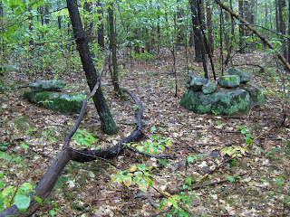
I came across some very well buried rock piles in northeastern Estabrook Woods, like this (see also here for videos):Some were completely invisible, like the one in the center of the following picture, and I cleaned off a few (like the one to the upper left):Only one pile stood out enough that you might notice it in passing:
I decided to be slightly unethical and clean off a few others. There are still plenty that remain buried and it is worthwhile both getting a sense of the site layout as well as making it easier to see that this is a site.

Once cleared, the piles can be seen to be more or less evenly spaced and in lines - characteristics of what I call marker piles. Here, the lower version of the picture shows where the piles are circled in red. Looking northwest:Looking northeast:Referring to the sketch above, this is in a shallow valley between a knoll to the west and a flat plateau to the east. A stone wall crossing the knoll on the western side is "fresh" and looks like most of the walls you see in Estabrook Woods.But there were also two short stretches of older wall, that look as well buried as the rock piles
These are obviously much older. I often see a couple of such short stretches of wall at a marker pile site; they are reasonably characteristic.

Interestingly, the newer wall was built along the side of a "rectangular" structure:This was the only place where the wall had an extra feature like this. Then I went across the valley, up onto the flat area and swept back back and forth, just to be systematic, and was thrilled to see this larger mound:Note the consistent size of the rocks in this pile.

There was another pile, on a boulder, up here in the flat area, and I saw one other off to the side, but that is all I noticed. So here we have quite a combination of anomalies on one part of the woods: an array of rock piles, older walls, a rectangular ruin against the newer wall, and also a very nice larger mound on the flat place to the east of the site. It turns out, looking at my topo maps that this flat place is the highest point - or at least the highest field (cuz I am ignoring a nearby crag)- in this eastern part of Estabrook Woods. The mound would be visible from a long way away. Here is the "MAPNIK" view:
Note that little "peak" symbol is a crag that must be familiar to people who have walked through this part of the woods. Perhaps it is relevant to this site, as its shadow would reach to here. I guess it is worth mentioning there were low rock piles on both sides of the shallow valley, shadows from the west (the knoll? the crag?) would touch piles on the eastern side of the valley and shadows from the east (the mound?) would touch places on the western side. Anyway...

Look how even the larger mound is nearly invisible from a few feet away:

Tuesday, October 11, 2011

Maybe the Indians were the first bloggers.

by Ernie Branscomb

Photo by Robin Shelly

"There is a Round Rock on a road, a few miles north of Laytonville. On that rock is what we used to call “Indian Writing”. I recall that the rock was quite intact and well detailed when I was a kid. I was deeply offended, for my own personal reasons, that people have chipped artifacts and writing off the rock. I can only imagine how the Indian people feel..."

In the Comments:
ben said: "Ernie...Some rocks have the circle designs and indentations called "Cupules". These may be "rain rocks". The local Indians were great ones for controlling the weather and the medicine maker would sing, pray and pound on the rain rock to imitate thunder. Even into the twentieth century there are stories about the old men contesting with each other to make it rain or even bring lightning. The rock at Spyrock is pictured in Vol. 8 of the Smithsonian Handbook of the American Indian. There is a copy in th Garberville library. I have seen one near Sherwood that is spectacular and includes a "seat", a place to call the spirit helpers. Each Indian community needed such a place to carry on their religious life, so there were (or are) many of them..."

Ernie Branscomb said...

I’ve seen a lot of “Cupules” as Ben called them. I had no idea what they were for. I thought that maybe they used them to grind their Pinole (Wild Grain Flour). They seem to be everywhere. I’ve also seen lots of zigzag groves, and I wondered if that they were snakes or lightning. They never have a head or a tail, just a zigzag line. One of the more common markings that I’ve seen are plain straight lines. Sometimes parallel, and sometimes all coming to a central point. I’ve been told that those were fertility grindings, and like Ben said, the females drank the grindings to have sons. One version that I heard was that the male did the grinding of the rock and fed it to the female to make sons. The rocks with the straight lines seem to always be serpentine based rocks. Did they only use serpentine for fertility?
Rain Rock at Sugar Bowl South of Hupa; rock is in center of foreground (1901)

"Shasta Rain Rock: a 4000-pound sacred boulder called the rain rock (formerly) located at Gottville down river. It was deeply pocked by the hands of medicine men over the centuries, who buried the rock 200 years ago to stop the rain and the flooding. A road crew uncovered the rock in the 1930’s then taken to a museum in Fort Jones where it resides today. Even non-Indians call to request that the tribe cover the rock on special occasions to prevent rain."
http://www.jeffersonstate.com/bhelsaple/StateofJeffersonScenicBy.html
http://www.fortjonesmuseum.com/

Eastern Esterbrook High Point - a new site (the videos)

Stumbled (literally) onto some near-completely buried rock piles, while exploring the north eastern edges of Esterbrook Woods on the Concord/Carlisle line. Some preliminary videos may give a sense of the place. Later I'll show photos showing these piles are evenly spaced and -sort of- in lines.
According to my theory of "marker piles", there should be some feature nearby that could cast shadows over the piles. Another video shows the slight valley or "dell" where I found the piles and I was thinking this place where the stone wall crosses a slight bump might have been that feature.
But across the way a level spot which is the high point of Eastern Esterbrook woods had a very nice elongated "mound" which, if there were no trees, would have been visible from a great distance. Perhaps its shadow would reach down into the dell but I do not think so.
Neat! that there would be such a fine mound at the highest point of
this part of Esterbrook Woods. Also it always nice to find a new site in my home town.

Monday, October 10, 2011

“San Salary” ritual

Photo courtesy of Ere-Chui Association of Obshchinas of the Telengit.

"This rite is performed during a new moon, and preparations begin long in advance. Stones are placed on hilly terrain to the eastern side of the house. A flat stone the size of a large plate prepared for lighting a fire. As soon as the first rays of sun are seen, the traditionally dressed master of a house and his family go to the chosen site. They burn juniper (archyn) and then put offerings of dairy products and meat in the fire and sprinkle it with milk. Bowing, they walk around the fire four times. The master walks in the lead and gives blessings, spraying them with milk. Those following him, ask for their wishes to come true in the New Year. The blessing should be spoken aloud only by a specially gifted person, capable of lauding the Master of Altai’s lands. They also tie white, yellow and blue ribbons on the trees. After the ritual people return home and treat guests with traditional dishes and give each other presents. They always ask: “Jyldy kandyj chykkan?” (“How was your year?”). And the response should always be “Iye”, meaning “in good health”. Later they celebrate with traditional festivities and traditional sports..."
http://www.culturalsurvival.org/take-action/russia/2/telengitpeople

Sunday, October 09, 2011

Tremper Mountain, Oddities

The stone above was near the rock piles in the previous post. It's likely, even probably natural, but the contours were enough like a stylized face that I thought it was worth photographing and posting.
There was also this huge standing stone elsewhere on the mountain, but it may well have been set upright during the blue stone quarrying process.

Just a reminder: There's a group on Facebook called Celebrating the Ceremonial Stone Landscapes of Eastern North America, where all parties interested in rock piles and these ceremonial sites are invited to join and post.

Tremper Mountain, Ulster County, NY

Tremper Mountain in Ulster County New York was, in the 1700s and early 1800s, the site of extensive blue stone quarrying. The stones were used for building and paving before cheaper and/or easier to use materials replaced them. Because of this, I looked on most of the piles of rocks we ran across on our hike as tailing rather than ceremonial piles. At one point, however, we came to an area with piles that seemed different. The pile above, for example, appeared to have a manitou stone leaning against it.
This was an area of about 30 stone piles, all on boulders, in a flat place near the edge of a cliff, about three quarters of the way to the top of the mountain or maybe even closer.
The pile above includes a stone with an oddly-shaped edge, set upright so the odd edge is facing up.

The pile above shows what appears to be a layer of older rocks with others that seem to have been added later laid on top of them.
As with most of the places where ceremonial rock piles are found, many natural but unusual rock formations occurred here, as with this (much taller than it looks!) rock wall with holes created as conglomerate rock was weathered and stones cemented in it fell out. It looked like a sort of Mesa Verde for gnomes.

There were also a few of these effigy-like rock formations that, while probably natural, would not have gone unnoticed by earlier inhabitants.
I have forgotten to post a more interesting face rock that I found close to the rock piles, so I'll post it in a second post.

Wednesday, October 05, 2011

Big messy rock piles - Horse Hill Left


I was going to write something about quarrying and ceremonialism as a container for discussing my confusion, when they occur together. At this spot, there is not that much justification for the idea of quarrying, only that much of the bedrock has been fractured and used in the rock piles. But if this is debris from quarrying, the rocks would not be so uniform in size. The video contains other hints that this is not just debris. Here is another example:Here are some other things from a few feet away (again, sorry for the blurry pictures - it was raining):[Note how the soil is lower in the gap between the piles and the suggestion of a path winding its way through there.]
A view over a vernal pond near the center of this place:

Petroglyphs and Arrowheads by the Stone Weir


Tony DeCondo at a fish weir visible in the Passaic, between Paterson and Fair Lawn, when the river is low.

LeBeau Fishing Camp & Weir Archaeological Preserve

"A large stone pile located on the east bank of the Quinebaug and extending to the eastern edge of the weir may have served as the base of a platform for fishing and related activities..."
http://killingly.net/vertical/Sites/%7BB3052547-E019-431F-A99D-4BDC39C1CDAB%7D/uploads/LeBeau_Fishing_Camp.pdf

Polygonal Mound (with no hollow) - West of Dan Parker Rd Groton MA

Another small mound from the site I visited yesterday (see here) west of Dan Parker Rd. This mound is conspicuously different from the many mounds to the east of the same road. At first I thought it was somewhat round in outline:
I video'ed it from above to show the outline,

and, now that I am home looking at the video, I can see that where the retaining wall is still visible the sides are straight between angled corners. The part that I was seeing as "round" is more like where the retaining wall has collapsed. So I take it that this is an example of something rarer than a rectangular mound, a mound with a polygonal outline. I know a couple examples of pentagonal piles a bit smaller than this one (Hycrest Pond, Acton Horse Stable) but this one would have to be hexagonal or heptagonal. I should also mention a site in Weston (see here).

Anyway, these are pretty rare and I am confused that 200 yards away on the other side of the hill the piles are rectangular and more conventional. Also, I would expect a hollow at the center, but it is not present or is much less visible than usual.

A couple of poorly formed panorama views, sorry about the blurring:
More to come about this site which I want to call "Horse Hill Left" but which is actually a southern foothill of Horse Hill on Dan Parker Rd.

Tuesday, October 04, 2011

Woodland Indian quartz arrowhead

On Friday after work I went back to one of the places I visited many times this summer, searching for artifacts. I have searched most of the area over and over but I thought it might be worthwhile to revisit some of those spots and focus on looking for worked slate or argillite pieces I might have missed. In this place, the ground is only visible in patches, and as the vegetation changes some of these places get covered and others perhaps exposed, it is very hard for me to do what I usually do and systematically search the whole area to ensure that no places are missed. I have to jump around from patch to patch. On this particular evening, I was carefully working my way along when I started to spot some broken quartz pieces that were still half-covered with dirt. This is a sure sign that I have not checked that exact spot before, I always dig these out and clean them off to decide if they are worth keeping. I explored that area carefully and was pleased to see this sticking up out of the ground:
This looks very much like a projectile point with the base half-buried in the soil, but without picking it up there is no way to be certain. In any spot with a lot of quartz chipping debris there will be a lot of broken triangular rocks that look more or less like this and most of them are not arrowheads. It could be a whole projectile point, it could be damaged or broken, or it could even be just a pointy flake. I have seen things like this where the visible part is just a small section of a big chunk of rock under the ground.  Sometimes even what looks like an arrowhead lying totally exposed on the surface will turn out to be something other than what it appears to be. This is particularly true with quartz because of the way it breaks, it does not show flaking scars well at all and a carefully shaped surface viewed from any distance does not look much different from a simple broken plane. Many times I take pictures like this and then pick the rock up and it is just a broken rock. Fortunately this was not the case in this instance.
This is one of my best finds, it is well-made, thin and symmetrical, and undamaged. It still has a sharp tip. I think the type is what is called a Greene or Lagoon point. I don't expect to find anything else like this for a while. A lucky find. 

West side of Dan Parker Rd - Groton, MA

(known sites in blue outline, new sites in red outline)

I have written a good deal about Horse Hill and Blood Rd on the Groton/Dunstable border here and etc. Thought I would go back and explore a bit further to the left hoping there would be more. There was, but it was a bit different. To the east, there were somewhat small rectangular piles with hollows, whereas to the west the piles were all messy and mixed in with what looked like quarry debris. But there were a couple of piles with good integrity and they were not rectangular and they did not have hollows. All in all a curious picture. There are apple orchards on the hill dividing east from west and I have no doubt that there was a good deal of historic period activity in this neighborhood that either was compatible with the rock piles or at least, that did not destroy them. I'll post a few other pictures later but here is the one I saw first. A pile in a corner between an outcrop and a stone wall:From one side:
A detail from the other side, with a quartz cobble:
Nice stuff. This is the Wharton Plantation (a tree farm) but it should all be a museum of the late woodland to historic period Indians.

First picture...last picture

Starting a walk you don't know if you are going to find anything, so you photo a thing of beauty just in case you do not find a thing of mystery. At least you won't go home with an empty camera.Ending a walk, after you have found lots of interesting things, you stop taking pictures of every little thing but you cannot resist a last bit of drama:

Finding Sacred Ground

Mapping Sacred Sites

Monday, October 03, 2011

North Georgia and Eastern Tennessee Rock Piles

GF Merritt writes:

...I thought I might share some pictures relevant to your questions about stone features in Georgia. Quick background: I did graduate work in archaeology, but now I do it in my spare time rather than to make a living -- my family says my hobby is to stand out in the woods and take pictures of piles of rocks in the rain. I've been studying sites in north Georgia and eastern Tennessee for about a decade. ... These pictures were taken at a site in Pickens County, northwest of Atlanta. I've catalogued at least 35 cairns at this site, along with some other features which may be historic (as opposed to prehistoric.) Many of the cairns are not in as good condition as shown here; I suspect that some of them have been vandalized by artifact hunters or people looking for "Cherokee gold". I would caution the curious that you won't find anything underneath -- the Cherokee put their gold elsewhere -- and dismantling the cairns destroys the real treasure. A housing development is also encroaching on the site. I spoke to somebody in the sales office for the development some time back. He was aware of the features, but believed they were just "old chimneys". Closer inspection of the cairns, as well as their proximity to each other, makes this unlikely. As with other sites in the region that people have mentioned, these cairns are on the side of a fairly steep valley, although this practice seems to have changed over time. Other locations seem to be connected to a watercourse.

Sunday, October 02, 2011

Barrett Park - Leominster, MA

Noticed a small park that might be worth exploring but it turned out to be too close to the city, more a city park than an undisturbed woodland. I did spot some rectangular piles but they were hard bye some other disturbances, uphill from the southern end of the causeway, that seemed more mundane than ceremonial. From further away:
It was raining and muddy underfoot. Photos are blurry but at least the fall colors were nice.

There was a bit of ceremony in there (a small prayer seat): To me, the main reason you might visit this park would be to see this pretty little waterfall:

Oval Pile with "satellites" - Concord, MA

Here is an unusual configuration of rock piles on a knoll looking over a swamp and pond in Concord.A knoll overlooks the top of a wetland, next to one of the brooks that feeds the wetland. At the top of the knoll is a boat-shaped or oval pile about 15' long and there are four smaller piles arranged slightly below it on the water side. The knoll has a natural view to the southwest over the water.

Here we are looking towards the knoll with the water to the left.
The pile in the foreground was made of light colored rocks:closer:
Here are some views of the main pile. It is an oval or boat-shaped rock pile:The impression is of a messy pile with larger rocks around the edges and small ones filling in the outline. I was suspicious of this pile until I went hunting around for others. I first noticed the one with light rocks but, looking closely, also saw three others on the slope down to the water:
These were pretty well buried:These also seem to incorporate lighter colored rocks.

Update: Compare with the 2nd photo from the end here.

Exeter Standing Stones Video from Larry Harrop

Norman sends this link:

http://www.youtube.com/user/CeremonialLandscapes#p/u/8/1HksH1MnAcY

Saturday, October 01, 2011

MHC Still Racist After All These Years

by JimP

Dear Massachusetts Historical Commission

We are reaching the two year mark since I sent off the above message to the Mass Historical Commission. I never received a response. Even worse, the offending information is still offered as fact on the MHC website. Even the link they provide to debunk stone piles is offensive to me.

Please join me by contacting the MHC at mhc@sec.state.ma.us and telling them how offended you are, too.