Wednesday, December 17, 2014

Places of Mystery - near Noon Hill in Medfield (2)

I was exploring another valley up to it's source and saw something peculiar:
Since we are standing here, let me explain that, to the left is what appears to be an artificial trench that drains a vernal pond just above the rise in this picture. We are looking at a rock pile built into the side of the gully and a propped boulder above:
So we walk up there:
There is the propped boulder, with a couple of piles to the left of it and maybe one behind it, to the right in back. Here is one pile behind it:
And a view back towards the propped boulder (hard to make out):
Last look:
This is a but unusual to me. I have seen piles arranged along the sides of artificially drained vernal ponds - (there is one at Minot Pratt Spring in Estabrook Woods, Concord) but no propped boulders. It is a bit like the brook at Triangle Farm Rd.

Places of Mystery - near Noon Hill in Medfield(1)

I walked up the valley from the road, just to make sure I explored that topography. And I came to a little cove with steep sides, topped with stone wall. I looked around and didn't see any rock piles and thought: "This is a pretty little cove, I would've expected to see rock piles here if anywhere". Before turning back, I stopped to relieve myself and, as I stood there, I noticed a surface of moss covered rocks on the far side of the cove that I would have missed, if I hadn't paused.
It is a big old rectangular mound. From above:
 View back into the cove:
I did not see anything else nearby. 
The woods here are extensive and I have barely scratched the surface. Little heads of valleys near the skirts of the hill, in brooks close to the Charles River are one place to look for sites. But there is plenty of inland territory higher up.

Tuesday, December 16, 2014

SW of entrance to Adams Farm - Walpole

See the little mound there? We are just into the woods; a bit of field visible at top right. There were other disturbances nearby. Not too exciting.
Some other odds and ends:
Nice walls:

Eggs and Ends

Norman Muller got me started by posting this photo: “Odds and Ends” Pomfret, VT
    And you may note in the comments that Curt Hoffman said, “Norman - This wall end is strikingly similar to some which Tim MacSweeney has shown me in CT!” – which was exactly what I was thinking. I had already sent Norman an email that included an attached image that isn’t the best photo I ever took, but it shows a very similar sort of thing, possibly the one Curt was thinking of:
….This just may “possess symbolic content and contexts that can be studied from a semiotic perspective as media of communication, as stimulants and reinforcements of cultural values and behaviour, and as signs of ethnicity… a pattern of animal ceremonialism to an ongoing program of cosmic renewal and maintenance that included the animals and their "spirit masters" in the above-world as key elements,” as Michael C. Wilson writes in “The "Placing" of Identity in Nomadic Societies: Aboriginal Landscapes of the Northwestern Plains of North America” - especially since I am tempted to interpret the above as possibly an egg in the (a) Great Serpent's jaws.
    The other side of this break or gateway in this row of stones is what may be more familiar to readers here, that big triangular boulder that resembles a snake-head at the end of a stone row (although this one is obscured by another large and possibly moved boulder):
Stepping back:
     Twice is just a coincidence, they say. Have I been noticing others (or searching my old photos for more that I sort of remember)? Well, sure; here’s one more, for now:

“The "Placing" of Identity in Nomadic Societies (2005):”

Monday, December 15, 2014

Norman

An Unusual Walled Enclosure

In April 2001, I came across a curious stone walled enclosure on top of a rocky knoll in East Lyme, CT.  I drew a small map of it at the time, which is posted below, along with metric measurements of he five large boulders on the knoll and the length of the walls linking the boulders.  The small arrow to the upper left of the drawing indicates the location of the small opening.  The overall outside measurements of this enclosure were approximately 29.5' x 19.5', and inside measurements would obviously have been much smaller.


Here are the notes I transcribed at the time:  "This 'corral' is odd in that it is nearly completely enclosed, the only exception being an inverted 'V' at the arrow, which is about 1.5' wide, enough, I suppose, to shove a small animal through it.  But how to get them out?  And the boulders are all on top of this rocky knoll.  Found there?  Moved?"

Attached are four photos I took at the time, the last one being of the inverted 'V' opening.  Trying to coax a small animal out through he opening seems daunting, and climbing in over one of the boulders to capture it doesn't seem very attractive, either.


View of the opening

Any ideas what this enclosure might have been for?

More about Queen's Fort

From Charles M. Devine (for other posts on this topic, click here):
 
 First two photos date 1978.

 By 1979, SW bastion had been rebuilt and a spiral was added to it. In Manitou, Dix would only say it "might" have been rebuilt. No "might" about it.

As seen in second photo here, there is no spiral arm passing in front of the tree to the left in the photo. In the first photo, it would have been extending off the far right. Photo needed to cover that area better then it does, but I can attest that there was no spiral, or remnants thereof, that I ever saw prior to the rebuild. I do not know who was responsible. Neighborhood kids did like riding their dirt bikes there all the time in the 70's and 80's. Should you chose to use these photos and info, please send me a link at that time so I don't miss it. It is important that future researchers understand these changes, so the spiral extension on the SW bastion is not misinterpreted as original to the feature. I do not believe it is.

Black Pond - Harvard

Reader R.M. writes: 
This was near the trailhead of Black Pond:

Algonquin Pipeline Expansion Project


   Rob Buchanan reminded me of this Rock Piles post, writing, "Here is an article I wrote about a stone structure site that is located in one of the parks (Blue Mtn.) that will be drastically affected by the Algonquin Pipeline Expansion Project:"
 http://rockpiles.blogspot.com/2011/03/case-of-curious-rectangle.html

Sunday, December 14, 2014

Norman

Pomfret, VT, Odds and Ends

Over the years, I've taken many hikes to sites in Vermont with the late Ernie Clifford, who was my main contact in that beautiful and fascinating state.  Rochester was my main focus, but Ernie also showed me many sites in Pomfret, the town of his youth.  

One warm July day in 2006, he took me to a site he had recently shown to a group from NEARA. As we walked along an old country path, we came upon a break or gateway in the wall, and leaning against an end part of the wall was a small standing or manitou stone, which Ernie had not noticed before.  


End view of wall in previous image

Because I feel that small standing stones often mark Indian constructions, whether they be walls or stone mounds, I stopped to study the gateway area between the walls  more carefully.  In the middle I saw a small quartz stone poking through the leaf debris, and then I began to uncover more stones, which turned out to be a circle, or perhaps an oblong, about a meter across.  Many of the stones in the circle were quartz.


Because of this discovery, and the fact that a standing stone was found leaning against the end portion of he wall, I concluded that the wall was probably Indian.  In a recent article by Ernie in the NEARA Journal, he concluded that single width stone walls in Pomfret, VT, that he studied were Indian, and this example would fit that category.


View of the end portion of the other wall

Given the fact that the wall is fairly straight, I've often wondered if this wall could have been built by Indians during the period when Vermont was beginning to be settled by Europeans in the latter half of the eighteenth century.

Saturday, December 13, 2014

Chase Woods - Dover

Not much over there. Saw some minor stuff on the hilltop. This was on the east side of the woods.

Friday, December 12, 2014

Norman Muller

The Wall on Dick's Ridge, Summerville, GA

Over two summers in the mid-1950s, Philip Smith, a graduate student in anthropology at Harvard University, embarked on a study of supposedly American Indian stone walls in northern Georgia for Arthur R. Kelly, a legendary Georgia archaeologist and founder of the Department of Anthropology at the University of Georgia.  Kelly had long been interested in Indian stonework, and in Smith he not only found a fellow Ivy Leaguer, but also a bright student willing to undertake the daunting task of studying and surveying the walls that were often located on high ridges and in difficult terrain.

Smith's research over those two summers resulted in an article titled "Aboriginal Stone Constructions in the Southern Piedmont," which was published in the University of Georgia Laboratory of Archaeology Series, Report No. 4, March 1962.  It is a fascinating report, the first of its kind, and in his conclusions he made the following observation about the seven or eight walls he studied:  "...one of the most striking features is he apparently deliberate purposefulness by which large boulders and outcrops were tied in with the walls."  This was a significant and insightful observation, and it conforms to my own views of certain walls I have seen in New England and beyond.  Moreover, it applied to Dick's Ridge wall in Summerville, GA, which was discovered long after Smith's article appeared.

The following map is a copy of one that Tommy Hudson, a Georgia native and rock art researcher made, and it helps to explain the features that will be discussed in this brief essay. 


On March 29, 2009, Tommy Hudson guided a group of members of the Eastern States Rock Art Research Association to he wall on Dick's Ridge, which is situated in the northwest corner of Georgia.  Interestingly, this ridge is part of the same geologic formation that is found on Lookout Mountain in Chattanooga, TN, just to the north, and Little Sand Mt. and Rocky Face Mt. to the south, all three of which have Indian walls that Smith described in his report.

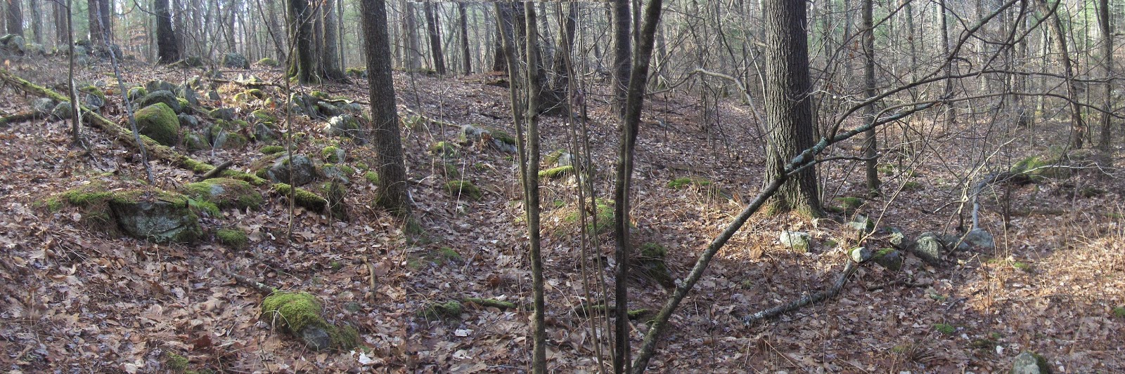
It was a steep climb to the top of the ridge, but once we got there, the terrain from the summit northward was fairly flat.  Approaching the wall from the south end of the ridge, we first encountered some vertical fins of sandstone.


As we continued north along the ridge, we came to the beginning of the wall which extended west across the ridge for perhaps thirty or forty feet before making a sharp 90 degree turn to the north.


For the next 300 feet or so, the wall traced he west edge of the ridge, encountering vertical fins of sandstone along the way that became an integral part of the overall design.  From a distance, the stone fins looked like walls.  


Note the wall beginning in the lower left

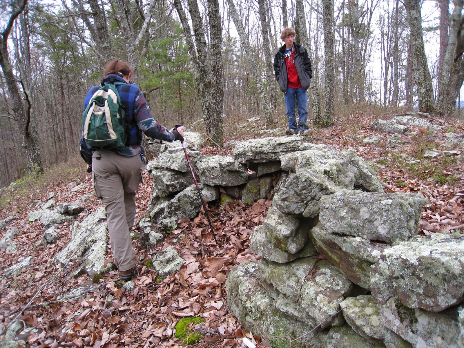
As we followed along the wall, I was struck by how large slabs of stone, some probably weighing a couple hundred pounds, were supported by small, fist-size stones, mimicking unusual construction techniques I had observed for pedestaled boulders, which are large erratics fully supported by three or four small stones.


Note the sandstone fin to the left of the wall

At some places where the vertical fins were exposed, a few rocks were placed on top to serve as a visual reminder that the fins were part of the wall.


At one point I saw a very large boulder at the base of the wall that was more than a meter long, fairly thick, and probably weighed close to 1500 pounds.  It must have required three or four men to move it into place.  


Further on we encountered a west-facing, U-shaped dip in the wall, what some of us call an embrasure.  


These unusual looking features have sometimes been interpreted as deliberate turns to avoid large trees, but the rocky character of the terrain at this spot does not support this interpretation.  We concluded that this indentation probably functioned as a prayer seat; a similar feature was found in a wall in Charlestown, RI: 


The U-shaped structure on Dick's Ridge faced west, toward the setting sun and in the direction that the souls took on their voyage from the Middle World to the Milky Way.  When we were shown an apparent rifled stone mound grave site beyond where the walls ended, which may have been of a significant person, it seemed logical that the prayer seat had some connection to it.


Rifled grave site

Among the piles of stone, Tommy Hudson discerned what he concluded was a stone cist grave.

Thursday, December 11, 2014

North Andover Country Club

I am often unsure how to describe a site, whether chronologically as I found it or in retrospect when the structure of the site has become clearer. Both have value because the chronological one explains the hunting process and the summary one notices characteristics and similarities. It sometimes matters what order you show the pictures in. Losing my PC obviates that problem - it's all text, except for the map from the Internet:
I got a tip from a former grounds worker at the North Andover Country Club that there were interesting things in the woods behind the golf course. So I went over there. 
Here is the chronological part: I didn't know this area and did not know if I should hunt for things "low" and near the water or "high" and on the hilltops. So, coming in from the south across the brook at a Beaver dam, I cut straight uphill towards the golf course. The ground is cut by ridges and valleys and, just before the top, I started seeing rock piles on the sides of the ridges. They turned out to be all down the side of the hill (so the hi/lo strategy wouldn't have mattered anyway) and were following a certain layout. 
There was a clear path, not exactly an old road, going from hilltop down between two of the ridges, with several different clusters of rock piles on the way down the hill. At the bottom was a stone wall with a opening into the wetland. 
Taking it from the other direction [this is the summary now], a path leads from the pond, through a well-made break in the wall (~10feet wide) up between the low ridges to the top of the hill. Clusters of rock piles appear on either side and also in adjacent valleys.
My informant said his boss told him the legend that the golf course was built on an "Indian burial ground." I can see how observant people might notice the piles and come up with that idea. But to me, the place had more the feel of a sacred pathway or perhaps a place for repeated individual ceremonies.
The only picture to survive was posted the other day here.

PC go boom!

writing from work. No blogging for me, until I get a new laptop.

Wednesday, December 10, 2014

Valdimar Samuelsson Cairns

     "Hi all. I have been working on new website on cairns. These are mostly from Iceland and some in Newfoundland and Labrador. My aim is to show how they are similar to New England cairns or in fact all east coast down to Virginia. It is best to check out the Album's one by one. This is still under construction so bear me.The builder of that cairn was Grettir the Strong in early 11 century..."


 https://www.flickr.com/photos/129039150@N07/sets/