Sunday, December 24, 2017

Abbot-Reed-Powell - Inner Valley of Oak Hill, Harvard

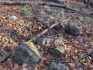
The LFH showed me a way into this Harvard Conservation Land from the uphill, Bolton Rd side. First we passed some small "box" piles, little rectangles with hollows and quartz at the edge:

Another:

Another:
The same can be found on 'Codman Hill' at the end of Murray Ln in Harvard.
Then we got further downhill, to a big mound (lower left blue outline on map above) I have seen in the past [see here]. It is impressive:
A short closeup video:
As you get further away, you can see how big it is:

 See it filling the ravine?
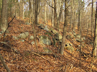
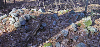
Then we continued northeast, up the valley, towards the woods behind St. John's Lane. The mounds continued, slightly smaller, one after another along the southern facing slope of the valley. 
 From above:
Another:
Another view of the slope:
Another mound:
View again, note how there is a smaller part to the mound, on the right:
More, right up behind the houses (must be tresspassing):
Another:
Another with two part structure:
This also matches the "Lazy 9" style, mentioned here.

A nice collection of mounds. This valley is a real mortuary "complex". Should be on the National Historic Register. All the woods there are full of interesting structures. Walls of different ages and shapes: 


 Hun?

Wednesday, December 20, 2017

Winter Solstice viewing in New England - anyone taking photos tomorrow?

Could not help but notice NEARA advertising the solstice at New Grange in Ireland. Seems like the they are missing an opportunity to promote New England.

Tuesday, December 19, 2017

A Harvard Valley

Abbot/Reed/Powell Cons land is down to the left:

Monday, December 18, 2017

Paleo Indian Site Distribution

(not rock pile related)

Really worth looking at this map.

It is clear that Clovis culture, however interpreted up till now, deserves to be considered most closely connected to southern Appalachia.

Saturday, December 16, 2017

Quartz Head - Harvard MA

Depending on the light this is either scary or invisible:
The face is pretty easy to see and, because it was carefully held in place by a shim, I think this is deliberate.

Southern part of East Woods, Boylston

Boy! Three weeks go bye and I cannot remember where I took the pictures. Ah yes! An undistinguished "ridge line" site in Boylston, which could be a pathway, or perhaps a marker pile site. It was a great deal like a site in North Andover - where there was a distinct feel of a pathway up from the water. As I review the pictures, I see there was a path way down to the water (cuz I started at the top).
A few pictures. Crossing a couple small ridges, I spot piles:

Up close on the ridge:


Then over and down
Heading down this way:
To a house foundation:
That was down to the western part (of the lower blue outline on the map) over by the water and, presumably, access to the site on the ridge.
Heading back a little further east, a standing stone:

I could believe this was a property boundary.
Then a bit further east, following the little brook to the north, not sure exactly where. Saw some interesting stonework in the wall:
 Closer, a weird culvert:

And a few decrepit mounds:

Already barely recalled.

Friday, December 15, 2017

Wednesday, December 13, 2017

Concord's Finest

Over Thanskgiving I got to take a walk with my son, here in Concord. Well this is Estabrook Woods and south of Boaz Brown's cellar hole - if you know where that is. I have blogged these places before but wanted to show my son some of the things in our home town. Some random shots:


If you love Concord, you'll wonder: where is that? I want to check it out. Well go downhill and right from Boaz Browns.
For what it is worth, Boaz Brown must have been a strange fellow. History records him as having married into one of the better-known Concord families but does not explain the proliferation of rock piles, mounds, short stone walls, etc. that surround the otherwise inconspicuous colonial cellar hole - remnants of Boaz's house.


A little east of Boaz Brown's on the south shoulder of the same landform, are my favorite pair of mounds in Concord. Rectangle's with hollows:
Note the identical architecture, with a "hollow" spilling out to the side like an 'entrance'.

Where there are burials for the aristocrats one also expects to see a burial for the common man:


And there is this famous "turtle" shell. Norman and I remember standing there with Steve Ells.
That was a while ago, and now I leave it to the younger generation to re-explore these places.

Friday, December 08, 2017

A reader question about Gungywump

[If anyone has the answer, let me know or leave a comment, and I will forward the answer.]

Do you know if the “local” nature center that Ted Hendrikson writes off still offers any guided walks?

I had tried to reach Vance Tiede via email as well through this name of his “business” but had no luck    :  (

Thank you in advance for any info you can provide.
Grateful,
Gaelle

Tuesday, December 05, 2017

NEARA and Sudbury Valley Trustees Fieldtrips - from Peter Anick

[Non NEARA members should consider going along and contacting the MA coordinator]

UPDATE:
Given the latest weather report, we'll have to postpone our planned trip to Shutesbury/Montague.  My current thinking is to wait till late February/early March, which will also give us a few more hours of sunlight.  Lots to see in that area. [check weather also on Dec 21]


Dec 17
Last year after a drought, a pond in Westford revealed an odd circular stone construction.  It looks like the pond should soon be dry enough to allow a visit, so we’re going to try on Sunday, Dec. 17.  The discoverer of the site will be on hand to discuss what the Indians and archaeologists who visited thought of it and then we’ll head over to the Westford Museum afterwards to see a video of the Indian account.  (There’s also a display there on the Westford Knight which you can check out.)    

The pond portion will involve about a ten minute walk over what may be a muddy trail, so plan on bringing boots.  If you would like to join us for the afternoon, please send a reply to this email and include your name and email in the text.  Details will be sent to participants early that week.  If the weather turns wet, we may have to postpone.


Dec 21
Neara member George Krusen will be hosting a solstice sunrise alignment viewing at a site in Boxboro on Dec. 21.  This event is sponsored by the Sudbury Valley Trustees, who manage the property.  I have been to this event several times over the years and have always enjoyed it, especially if the sky is clear.

Description: View the winter solstice sunrise through the stone structures at Half Moon Meadow Brook, and hear the legends of their origins from leader George Krusen. The sunlight bores through the stones for a magnificent viewing.

Friday, December 01, 2017

Photos from NEARA Fall Conference in Warwick RI

[I do not have a link.]

[There is one photo of a stone wall ending in a small circle. I have seen this pattern in many places but never so clearly.]