Actually, I walked in along a power line, seeing a mound at 'A', an interesting split wedged rock at 'B' and a number of brook-side piles of various sorts, around 'C'.
I wanted to get to that beautiful landform between the swamp, left of center, and the river, not shown to the left of the map fragment. I guess my legs are getting weak, or the day was getting late, cuz the featureless lowlands discouraged me.
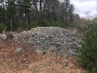
The mound at 'A' was a reasonably typical rectangular mound with inner structure. It is built into a wall. Walking southwest from the road, under the power lines I find:
I see a white rock on top.
Looking for details, I do not see much, just that there was some structure, now, degenerate.
[Update: Look again, it is clear someone drove a heavy piece of
tread equipment up on top of the pile.]
Looking back:
I did not find a lot later, so took other pictures at the end of the walk. For instance, of this smaller one a few yards away:
And some details on the back side, showing the sense of "corner" on the rectangle:
Showing small "chambers" near another corner:
Quite a beautiful example. Should be relatively safe, there under the power lines.
Other things worth showing from my walk include this interesting example of a wedges inserted in a split boulder. I never saw an example like this:
Some of these inserts look modern. Also, some real effort went into getting those small rock jammed in there. Increasingly I get a sense that there are some modern people, Indians, who know something about the uses of ceremonial features.
For the record, these are called split-wedged rocks or split-filled rocks and not "split-wedged cairns". I discovered them and I get to name them. I assume the users know other names.
Also saw this wall bulge:
And this pretty little pile by itself near 'C':


