From reader Kerry G:
Update:
Monday, December 10, 2018
Sunday, December 09, 2018
Strolling in Woods Hole
Went for a walk in Webster Woods, planning on visiting a place I know, then swinging down through the Oceanographic Quissett Campus. There are so many nooks and crannies in those woods, when I came to some rock piles I was not sure if I was already at the site I knew. It turned out this was a new little cluster of items.
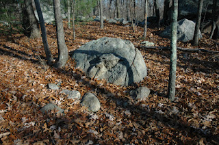
To start, there is a ridge, not far from and more or less parallel with the main road. A friend told me he used to walk to Falmouth along the ridge and that it was an old trail. Following that trail, just north of the fire station, came across something quite rare: a rock-on-rock made of quartz:
So there are burial mounds down here on the Cape. You could argue there is a hollow in this second one but I would not call this or the previous one "rectangular".
To start, there is a ridge, not far from and more or less parallel with the main road. A friend told me he used to walk to Falmouth along the ridge and that it was an old trail. Following that trail, just north of the fire station, came across something quite rare: a rock-on-rock made of quartz:
[sunlight would go through the quartz at right time, since the sun is at the horizon occasionally]
The only time I see this is on a boulder looking out over the scene. In this case I crossed the wall and continued along a faintly visible trail till I got to some rock piles.
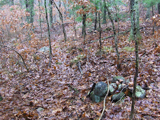
You have to look closely to see them in the photo. They would be easy to miss on foot. You can see from the stone wall in the background that these are on the slope below the ridge. Here were a couple more:
You can see the trail plainly in this picture.
So I am thinking these are marker piles - along a slope, in a sort of row but without much individual character. Then I came to a 'mound' of a type which, in more northern parts of Mass., is often found next to marker pile grids. I have written about this association before. So here is a mound:You can see the trail plainly in this picture.
At first you say: "well that is not a rectangular mound with a hollow", then realize that this is pretty much the same as the recently named Wrentham Pavement: a southeastern MA expression of mound-ness. And from this, and the absence of the fresher 'cairns' one sees further north and over at the CT/RI corner, I conclude a shared culture throughout this area of MA - south of the Charles River watershed. However there is some reason to think this culture is found throughout the state but hidden by more recent and visible things. I think of these pavements as being older.
It is interesting to see this mound in the context of the other piles adjacent to it. It is next to what I think of as a collection of marker piles - re-enforcing that the association of mound with calendar. And the rock-on-rock made of quartz, overlooking the whole arrangement (we are within 50 yards of that rock-on-rock and it would be visible from here) is a nice detail. Such details were not available in Wrentham. This place is relatively undisturbed, sitting as it does, next to the trail to Woods Hole.
Across the little valley was another messy mound:
So there are burial mounds down here on the Cape. You could argue there is a hollow in this second one but I would not call this or the previous one "rectangular".
Tuesday, December 04, 2018
Monday, December 03, 2018
Greater Rhode Island Ruins
Some interesting images from:
Greater Rhode Island Ruins
Greater Rhode Island Ruins
From: "Avalonia Land Conservancy - TriTown Forest - North Stonington, Griswold, Preston - Random enclosures and cairns ... somewhat similar landscape to the Canonchet Preserve in Hopkinton."
Some "cairns," as they describe them (above) and a U-shaped Enclosure (below), which reminds me of a spot Curtiss Hoffman and I pondered about which direction something similar but not identical at Judges Woods faced, the "seat back" also bedrock...
I am assuming that this is a view of the row of stones up above the possible Prayer Seat:
Thursday, November 29, 2018
Holliston site with Norman Muller and Bruce McAleer
Norman writes:
You attended that field trip to Holliston that Bruce McAleer led in November or December 2005 . A fascinating site, and one of the features that intrigued me was a fairly large erratic with three smaller stones aligned in a horizontal row in front of it (0055 below) . I was certainly struck by this, which is the reason for the photo. Another view shows the same boulder with two other erratic in front of it (0056). To me, the alignment of the three smaller rocks in front of the first boulder is significant, and I wonder if these three smaller rocks in alignment simply signifies the three larger boulders in a row. I also wonder if the vulva shape on the boulder means anything, or if I'm reading too much into it. The Native Americans were certainly aware of shadows and how they can change how one interprets certain features.
What do you think?
Wednesday, November 28, 2018
Ceremony at edge of deer hunters' camp
At the edge of a hunter's camp. First I saw something white and assumed it was a trash bag, but to be systematic I took a closer look and found a small quartz rock in a loose line of other rocks - with a rock pile down the way:
Closer:
Other views:
Closer:
Having just posted about an effigy, makes me want to see this as another example. No matter.
There were a few other rock piles about, of a size, distribution, and placement on a flat slope, as to suggest "marker piles".
And
And
You can see a bit of path, innards to the left, the quartz arrangement beyond in the background.
So, when I see what look like a collection of marker piles, I look around the edges for rectangular mounds with hollows (burials) and this had me notice something I would not have noticed otherwise.
Lousy picture too! Just the suggestion of a level spot and an outline - a bit of soil/rock pushed out, away from an outcrop. Shaped a bit similarly to a "mound with hollow".
Tuesday, November 27, 2018
Bird Effigy Rock Pile?
A short walk with my son at the Pond Street Cons Land in Norfolk MA. We went there as a backup plan to the place I selected that didn't pan out. Too bad I did not know the topography or we might have taken a longer walk. Saw this:
Can't resist a picture of Joe Waksman
The bilateral symmetry is enough to consider this might be an effigy. "A bird?" he asks.
A few feet away:
A nice brook, we decided. Looks a bit manipulated.
Can't resist a picture of Joe Waksman
The bilateral symmetry is enough to consider this might be an effigy. "A bird?" he asks.
A few feet away:
A nice brook, we decided. Looks a bit manipulated.
Friday, November 16, 2018
Along an old wall
I found a distinct and well made rock pile, covered mostly with soil and dead leaves. An old bucket might have been a donation.
Southern Sherborn
At the end of a short walk in the area, I found a messy "mound" up on the top of a bluff looking west over Sewall Brook. Similar bluffs run north of there, up through Pine Hill and Brush Hill, and I expect similar "mounds".
After some walking around, I finally found one rock pile, a bit like a donation pile but damaged:
A piece of pink granite in the mix:
Then I am going up towards the bluff:
Here it is from above:
After some walking around, I finally found one rock pile, a bit like a donation pile but damaged:
A piece of pink granite in the mix:
Then I am going up towards the bluff:
Here it is from above:
There was nothing crisp enough to call a "hollow" but there were some signs of structure. I would call this a "Wrentham pavement" and suggest, since this is the Charles River watershed, it is part of the same culture we saw recently at Birchwold in Wrentham.
Other views:
Looking at the lower slope of this pile note the curved line of rocks on the right side of the picture:
Examining these more closely:
This begins to resemble a bit of "marker pile" structure and the suggestion is that the even slope below the mound played that role. Since this is in association with the large mound above, it is an interesting detail.
It is a grand thing, and nice to see in the context of the Wrentham finds. In the above picture, the hill slopes down to the right and becomes a ridge. A few feet along there, there was a bit of something else:
In time we can explore those bluffs north of here, to look for similar sites.
Wednesday, November 14, 2018
Saturday, November 10, 2018
Somewhere in the White Mountains of New Hampshire
I am sitting on a slab of rock, with smaller rocks propped up around the edge. When I was about 5 years old, we did not think about stonework and archaeo-astronomy. Apologies, my Dad did not understand things like cleaning the camera lens.
Anyone recognize this spot or the background mountain?
Anyone recognize this spot or the background mountain?
Thursday, November 01, 2018
"Running Stream On My Off Grid Property And Possible Indian Structures"
From YouTube [good stuff if you stick with it]
https://www.youtube.com/watch?v=aHpzN1k6Vng
https://www.youtube.com/watch?v=aHpzN1k6Vng
"Secred Site --Ledges, Mound #5--Covered Earth Chakras and Charged Air"
From YouTube [ just cuz of the mention of his dog :) ]
https://www.youtube.com/watch?v=ZZH2TC29a9I
https://www.youtube.com/watch?v=ZZH2TC29a9I
Subscribe to:
Posts
(
Atom
)


