Monday, August 02, 2021
Cape Cod Museum of Natural History
Sunday, July 18, 2021
Name that rock
Update:
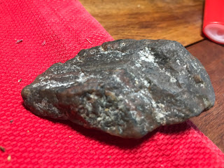
I am posting a new pic of this material, against a neutral background, an unpolished surface.
I believe this is called a metamorphic igneous rock. Does it have a name? It is from glacial gravel on the beach.
Previously Had:
Can anyone offer a clue about what kind of rock this is? It looked like granite at first but it is mostly a reddish mineral:
What I take to be a working edge, was upper-right in first pic, lower-right in second pic. Here:
Monday, July 12, 2021
Monday, July 05, 2021
Trail Maintenance with Stile/Style (Essex CT)
I usually find myself shaking my head at "Trail Maintenance Photos" that breach "stone walls" and otherwise disturb probable Indigenous Ceremonial Stone Landscape features, but I'd like to give a CSL award to the Windswept Ridge Preserve of Essex, CT for this remarkable alternative to disturbing possibly quite ancient rows of stones or Qusuqaniyutôkanash...
(Photo by Jason Greene:)
Tuesday, June 29, 2021
Mounds from Spring Creek, PA
Reader Jon sends new pictures:
Here are some photos I wanted to share with you. Rock Pile A is images 1002, 1008 and (1009 from 2016). Rock Pile B, 100 yards away is image 1004.
Friday, June 25, 2021
The 2,300 Y.O. Stone Pyramid Mound & Fort | Glenford Fort Preserve
Note the dating of some stone mounds in Ohio, consistent with Oley Hills dates:
The 2,300 Y.O. Stone Pyramid Mound & Fort | Glenford Fort Preserve | - YouTube
Tuesday, June 22, 2021
Some images from Jim Wilson’s Zoom Presentation
Watch: https://fb.watch/6fxQG6CmSB/
Sunday, June 20, 2021
Underwater archaeology team finds ancient obsidian flakes 2,000 miles from quarry
“An underwater archaeologist from The University of Texas at
Arlington is part of a research team studying 9,000-year-old stone tool
artifacts discovered in Lake Huron that originated from an obsidian quarry more
than 2,000 miles away in central Oregon.
The obsidian flakes from the underwater archaeological site
represent the oldest and farthest east confirmed specimens of western obsidian
ever found in the continental United States.
The find in Lake Huron is part of a broader study to understand the social and economic organization of caribou hunters at the end of the last ice age. Water levels were much lower then; scientists have found, for example, ancient sites like stone walls and hunting blinds that are now 100 feet underwater.
“This particular find is really exciting because it shows
how important underwater archaeology is,” Lemke said. “The preservation of
ancient underwater sites is unparalleled on land, and these places have given
us a great opportunity to learn more about past peoples.”
https://www.uta.edu/news/news-releases/2021/06/15/lemke-lake-huron
Citation: O’Shea JM, Lemke AK, Nash BS, Sonnenburg EP,
Ferguson JR, Nyers AJ, et al. (2021) Central Oregon obsidian from a submerged
early Holocene archaeological site beneath Lake Huron. PLoS ONE 16(5):
e0250840.
https://doi.org/10.1371/journal.pone.0250840
Saturday, June 19, 2021
Falmouth area arrowheads - ID requested
Can any one identify the arrowheads here:
I am particularly interested in this one, which looks like a late stage "paleo" point:Note the base is "thinned" compared to the upper part.Wow. Wish I found it.
Wednesday, June 16, 2021
Another "Chamber" Video
The "Rattlesnake Squamation/Scalation" Variation
I just watched this video from Mike Luoma of VT yesterday. We've been communicating electronically on FaceBook and I sent him this image below soon after viewing it:
Tuesday, June 15, 2021
Monday, June 14, 2021
Saturday, June 12, 2021
"Horned Creatures"
A Horned Creature from 2008, and some H.R. Schoolcraft illustrations from the late 1800s:
Wednesday, June 02, 2021
Clovis First Dies (AGAIN!)
New evidence may change timeline for when people first arrived in North America (phys.org)
[Research from 20 or so years ago at Monte Verde in Chile already changed that "timeline". Seems like the only people still promoting a 13K time depth for man in America are textbook writers and YouTube.]
Monday, May 31, 2021
Wednesday, May 19, 2021
Land Protectors Win One for Nayyag - Ancient Native Site Rescued
Nohham Cachat-Schilling writes:
“MassDOT has determined that the best next step is to terminate the current construction contract and undertake a re-evaluation of the project design. The re-evaluation option is responsive to the nature of the public comments received, which asked MassDOT to consider alternatives that avoided the location of the archaeological site,” the notice said. “This re-evaluation will take public opposition into account as a key evaluation criterion for all design alternatives considered.”
Friday, May 14, 2021
Whaddya Think?
Found on an island, wrong material but this looks like the base of a Merrimack (Stark) point:
scalloped edges:Wednesday, May 05, 2021
Oley Hill site dates to 2500 years ago
I asked Norman Muller about his dating result for the Oley Hills. They used OSL (Optically Stimulated Luminescence) to arrive at a date of 2500 BP, for one of the terraces at Oley Hills. He wrote:
Yes, the Oley site is much older than Cahokia. I am of the opinion that the large platform stone mounds in the Northeast were inspired by the earthen mounds in the Midwest. Or maybe the influence went in the other direction! You are aware, of course, of that large geometric earthen mound in western MA (see LiDAR attachment; the mound is about 50 feet high and 200 feet long at the base; the top is precisely oriented to the cardinal directions. I visited the site with Timreck and Lisa Gannon).
Sunday, May 02, 2021
Ontario Mounds
Reader Joanne writes:
Mike Martin's Cave
A reader writes:
Rock Piles contributors, especially Jimp:


