Monday, March 27, 2006

Fieldtrip to Pelham Mass with Bruce McAleer

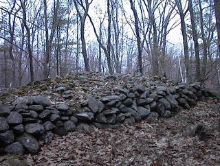
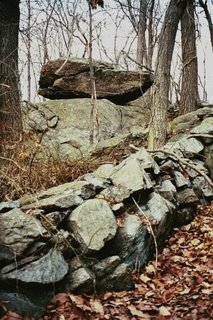
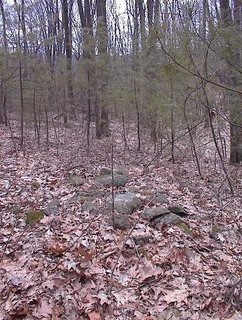
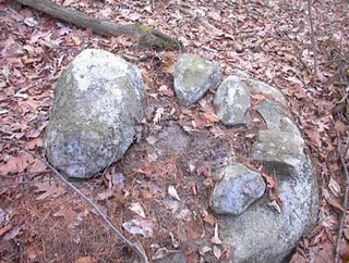
Bruce McAleer had read about rock piles in a UMass forest-use report about Cadwell Memorial Forest and proposed we drive out to Pelham Mass, way out on the west side of Quabbin Reservoir, and try to locate some of the piles there. The season is perfect for it because it is easy to see through the woods without foliage. Bruce drove and I was spotting for rock piles out the car window and even as we drove west on Rt 2 I started seeing piles in the woods to the side. When we turned south onto Rt 202 around Athol Mass, we agreed that if I saw any more rock piles we could stop and take some pictures - all part of the field trip. So as we are in New Salem I saw one rock pile ("there's a rock pile!") and then another - looked like low platform piles in the woods. When we stopped and got out to explore it was an incredible site, as I'll describe in a subsequent post. But after that we drove on and, a minute or two later, saw another site, this one a more traditional marker pile site on the side of a hill. We agreed at this point that Rt 202 should get this year's Rock Pile Highway of the Year award. Later, we did explore the Cadwell Forest and saw three or four other rock pile sites, then we came home along Rt 202 and this time I was facing out the window towards the other side of the road and saw yet another rock pile site in New Salem.

Over and over Bruce and I agree that there are rock piles all over. Not just on the hills, nor just by the swamps, nor even along special alignments. They are simply everywhere. I think the question is why don't people see them, how could they go un-noticed? Perhaps most people don't get out much and those that do are used to ignoring anything that looks like a stone wall.
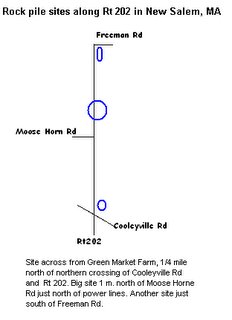
Anyway back to Rt 202 and spotting rock piles. The first site was about a mile north of Moosehorn Rd, just north of the power lines mostly on the east side of the road. There would be a very fine view from here southeast into the valley which, today, contains the reservoir. Then the next site was a bit north of Cooleyville Rd on the southeast side of the road of 202. The third site I spotted, on the way home after we ran out of time and picture memory in my camera, was just south of Freeman Rd on the east side of the 202. I love these road names. I was saying "Moosehorn Road" for the rest of the day. I was worried I would not have any room left in my camera after Moosehorn and Cooleyville Rds. In fact I had used up about 28 of the 40 available.

So we got to Pelham Mass, went south on Packardville Rd and entered the Cadwell Memorial Forest at the first main entrance we saw. From there we walked straight in, northward, past cellar holes and rock piles for about a mile or so. Some of the pile we saw were not on the map. Then we curved around to the right, starting back south, saw a Civil War cemetery and missed seeing some of the mapped rock piles until we arrived back out on Packardville Rd and walked about 1/2 mile along it to get back to the car. I was so cautious about not using up remaining pictures that I still had 8 unused, so it was a good thing Bruce wanted to visit one last corner of the woods. We drove over there, took the 8 pictures, and then headed home.

I would like to describe some of the sites we saw, taking it a post at a time.

Carter Reserve - new photos from Larry Harrop

Beautiful as always. Head over and check Larry's new photos. [Click here].

Sunday, March 26, 2006

A great day out west of Quabbin

Too tired to report much but I went on a field trip with Bruce McAleer out to Pelham Mass and we saw lots of rock piles on the way, lots more when we got there, and more still when we had run out of time and film on the way back. So here are a couple of appetizers. Full reports during the week.

There was an impressive platform site visible from the road along Rt 202.

There were beautiful piles under the moutain laurels in the deep woods of Cadwell Memorial Forest.

There were blazed ground piles, perhaps burials, in another part of the forest all quiet along the road. Each pile with one or two noticable chunks of white quartz.

The Pond Dwellers by Kelly Savage

Thanks to George Krusen for providing information about this book: The Pond Dwellers - The People of the Freshwaters of Massachusetts 1620-1676. Panther Publishing. PO Box 181 Wales, MA 01081, 1996

A couple of quotes George passed along:

"...I pulled it (panther skin showing his royal status as pow-wow) closer to me and climbed a short way down the mountaintop to the natural half stone half circle seat where I would often sit and observe the stars. As part of my training, I had gone with Elk Bones and our local pow-wows to similar seats around quansik. Near the place where I was born in quoquanset there was a bowl valley at the bottom of the hills with a small cavern in the bottom that we used as a watching place. There were notches and piles of stones along the rim of the bowl and I learned how to watch for where the sun, moon, and certain starts set and rose in relation to them. Off the path from quoquanset to asquoach there was a very ancient sacred site near the stream. Overlooking a crudely shaped Mother Stone there were several circles made from stones, each large enough for a brave to sit in. The area was full of quartz rock and I was told it was where a man could talk directly to Mother Earth..." - p. 117

"...Of this reason we always had young braves on the hillside in horseshoe-shaped stonewall enclosures. There job was to watch below, to scan over the valley and hillsides to warn of enemy approach. ..." - p.143

"...we anxiously expected to hear the deep booming of the large balanced rock near the fort that would warn us to return at once. ..." - p. 167

Oley Hills Part Six

By Geophile

Why is Oley Hills significant?

While Oley Hills is a curiosity, it isn't inherently more important or more intriguing than smaller sites, at least for the rock pile enthusiast who is taken with the charms and subtleties of the sites nearer to home. Its real significance, however, lies in its possibilities for the future recognition of the sites. Its sheer size and peculiarity can make even skeptical people admit that something is going on here.

And if those qualities can get it recognized as a site worth preserving and studying, the elements common to it and other sites could be pointed out.


There are the interestingly-shaped boulders,


odd elements like vertical stones stuck in the ground near boulders,

boulders linked by wall remnants or rock piles, and many other elements familiar to people in the field.

The largest section of Oley Hills was recently purchased by private owners, and we don't know what fate those owners may choose for the site. We can only hope that the wonder engendered by the place will capture their imaginations and help the site survive, until that inevitable time when something causes the archaeological community and society in general to remember that human habitation in the northeast goes back much farther than 400 years, and enables them to see the evidence that lies all about them on the landscape.


Cobbles placed in a recess at the base of a boulder. Many of these small stones seemed to have been placed recently.


Artistically placed rock pile

Faint traces of a calendar site in Ayer

The paved part of Snake Hill Rd in Ayer ends just shy of the hill at a Rod and Gun club. If you park there and head west into the woods, there is a lake about 1/3 miles away, surrounded by houses. Just before the lake and houses there is a last bit of bedrock hill and the highpoint of that bedrock is a place where, as you turn and look around you, there are about 8 different horizon directions marked by a small pointed standing stone poking up over the near horizon.
These pointed stones are inconspicuous and the site is not too impressive but I suspect this was a calendar site.

Nearby were other small knolls which could have been auxilliary sites and there were a number of large rock-on-rocks which might also have been playing a role in marking the horizon.
So it appears that some rock-on-rocks might be built as simple horizon markers.

Friday, March 24, 2006

Odds and ends from the backwoods in Carlisle MA

A couple of rock-on-rocks from the edge of a swamp:Then this pretty fine example of a wall bulge. Right at the top of an outcrop, this certainly was a nice pile. There were possible fields nearby.
You can see the edge of this next one from Concord Rd if you look carefully and risk an accident as you drive around a curve:
I see this as a possible effigy, with the head to the left and slight damage to the right.

Grave Undertakings - a book review

Thanks to Bruce McAleer for this link:
http://www.wm.edu/oieahc/wmq/Jan03/linebaughJan03.pdf

From a review of Grave Undertakings: An Archaeology of Roger Williams and the Narragansett Indians. From the William and Mary Quarterly Vol LX, Number 1

...The final chapter, "Remembering the Dead", explores the meaning of individuals burials for later generations of Narragansetts. Rubertone examines the ways that these burials and this cemetery were remembered and commemorated by subsequent tribal members, drawing on textual accounts and oral tradition. In the process, she exposes native peoples' struggle to maintain an "active relationship" (p. 166) with their ancestors. She details the archaeolofical evidence --intrusive pits, broken ceramics, and stone piles-- that provides "tangible testimony to the Narragansetts' involvement with ancestral burial places" (p 173)....

Thursday, March 23, 2006

Oley Hills Part 5

By Geophile

Things can look like other things accidentally. One day our cat was playing with a string, and when she walked away, the string defined what would have been a perfect profile of a face. That's chance. It happens. Sometimes rocks look like things. When the likeness is very close, it can seem uncanny, more so to the minds of people who don't read written language. The kind of symbolic thinking required for literacy was originally projected on the world surrounding us. In a sense, ancient people 'read' the earth, living things, rocks and stars.

There's a lot to see at Oley Hills. Both times I was there, the distress caused by the disconnect between what I'd always known and what I was seeing had a strong effect on me. Berks County was where I had lived for most of my life, and to have Northampton County natives take me there and show me impossible things was a mind blower. So maybe that's why I experienced a state of uncertainty as to what was there and what I was projecting, what was real and what was not.


The perched stone above seemed pretty innocent. Yes, it kind of looked like a dog head, as someone pointed out, but its significance surely lay in its positioning and the way the wall led you to where you couldn't miss it.


The second time I went, I had my son with me. The first time I had spotted a boulder that looked like something, and I wanted to see what he thought. (I was afraid anyone else would think I was nuts). But on the way to the boulder, he stopped me to show me the stone in the picture above. It looks like a crow, he said.


We finally got to the boulder, and he said he, too, thought it looked like a duck head. This photo doesn't do it justice, but I used it because you can see the wall linkage to the left. In case you can't see the duck, his hand is just above the eye. For anyone who's curious, I have much better shots of it.

He wandered off to be with the young child of someone else who was there, but I was seeing things in rocks wherever I went. The rock above looked like an old man with his eyes closed.


The rocks in the picture above looked like a warrior to me. Was this some huge ancient gallery?


As we left, someone pointed out the above and said it looked like a turtle, but that didn't work for me. Still, although you can barely see it from this angle, a wall, interrupted by the modern road, runs right up to the formation.


And then, as it was getting dark, I passed this boulder. The picture is of poor quality because the light had grown dim, but to me this looked a lot like the turtles I'd played with as a child, only 20 miles away.

We can't know what the people who piled the rocks did and didn't see in the boulders around them. But one theory of why some stone sites around the world are where they are has to do with electromagnetic frequencies. While some scientists are attaching electrodes to the heads of meditating monks and measuring the frequencies of their brainwaves as they reach transcendent states, others are measuring low sound waves generated by the running of underground water and electromagnetic frequencies generated by minerals like magnetite.

Some claim to have found that at special sites the frequencies in the earth mimic those of the meditators, and may induce states in some people. For some time, thinkers like Paul Devereux have discussed the possibility that the landscape itself can in some cases be a hallucinogen or an entheogen. He cites the Australian aborigines' dreamtime as an example of the process in action.

Even here, a lot of people who've spent good amounts of time outdoors, especially as children, can relate an experience of epiphany or timelessness that, while our culture has no framework for it, is very much like what many other cultures would call a communication from spirits.

Things that have long been dismissed by Western civilization as pathetic fantasy may, in the decades to come, be found to have a scientific basis. I'm reminded of a conversation with a tribal elder that someone told me about. He said that in the old days, before cars and trucks and planes created vibrations and before radio and TV sent all these waves through the air, you could get, at certain places a feeling or vibration, maybe like electromagnetic frequencies, that made you feel a certain way. Some stone piles and walls were built to mark sites like that.

The rocks of the ridge on which Oley Hills is built are mostly gneiss, but within it there are pockets of magnetite. Does this have any bearing on the placement of the site, or on the readiness I experienced to see faces and creatures in stones? I don't know. While I like to hear theories and informed speculation, I'm not convinced until facts fall into place.

Sorry to take up so much room with this topic. The next and last Oley Hills section will be odds and ends photos and a short wrap-up.

The classic field clearing pile - from the Journals


This is from 1998:
I went back this afternoon to Wetherbee Avenue, in Acton Conservation land, to try to find some "mounds" I had seen earlier. I did locate one, and also got a photo of the first field clearing pile that I measured. Here it is, the classic field clearing pile. You can see my blue chalk marks for the quadrant I measured. This pile could be mistaken for a turtle mound because of the large "head" to the left. However there are several other large rocks of this size underneath this one and to the left, so it is not a solitary large rock. There are other characteristics that distinguish this as a field clearing pile. Firstly it is a recent pile, there is little buildup of debris and the rocks are still pale. Secondly all rock sizes (except six inches) are well represented, with many more of size six inches. Thirdly the pile is uneven, with many rocks strewn around the edges as is expected since a field clearing pile does not need to be well made. Apparently one key characteristic is the presence of small rocks. There are many six inches and smaller. This is not at all the case for the other piles measured today, where a six inch rock is rare and most rocks are between eight and twelve inches. Forthly this pile is at the edge of a field. Another important characteristic of field clearing piles is the slope of the rocks on the surface. This is called the "angle of repose" which is the natural slope assumed by material piled up and allowed to come to rest under the force of gravity. Roughly this is the same angle as you see in the banks beside the highway, and it is visible in the classic field clearing pile. Other piles examined are either low, without height or are domed, indicating careful construction.

Oley Hills Part 4

By Geophile


There are extensive walls at the Oley Hills site. As I recall, though, only one area was actually walled in, and that area held few features. Note how in this wall, the flat sides of the stones face out. Contrast that with the pictures that follow.


Frequently the walls meandered, going out of their way, or so it seemed, to link interestingly-shaped boulders as well as rock piles. Some people in our party refered to the linked stone above as "the sleeping Indian." At first I didn't see it, then I saw it. But did the people who built the wall see it that way? How can we know?


Another wall-linked boulder. Two things about this one. One--and this could be irrelevant--there is a flower native to the area that is the shape of this boulder. I don't know what its Indian name would have been. We call them turtle heads. Two--notice how the rocks on top of the wall seem to be lichen-free, as if they are more recent additions. Is that just chance appearance? Or, as I am not the first to ask, are these sites being kept up?


A wall passes over another curiously shaped stone. One possibility is that some of the walls are story walls, leading, like a 'stations of the cross' from one image to another in the form of boulders and rock piles of certain shapes, each representing a segment of a story or creation myth.

Tomorrow, or maybe tonight, I will post some photos of stones that look like things--or not--and discuss things that may be related to the placement of some sites.

Wednesday, March 22, 2006

Radio Tower Hill in Andover

Went for a short walk at lunch with a friend from work and found a small rock pile site. My workplace is between Rt 495 and the Merrimack River in Andover Mass and there is still a large chunk of woods in there. I have been exploring odds and ends and finding disappointingly few rock pile sites in these parts. Mostly, the woods seem not only raped but beaten and murdered too. Either the farmers around here were genuinely destructive or else the "hidden Indians" abandoned this part of the world before the farmers; so they never came back to heal some of the wounds. Anyway there are not many sites up here in Andover or else I have been unlucky. But today we did find a small site near the very top of the hill with the radio towers. This is a hill you can see for miles around, north of 495. We parked at the top, next to the access road to the highest tower and walked in, downhill southward, towards the highest tower. At its foot my friend indicated we should go down the trail to the right but, after a moment, I said I would prefer to go down to the left, because I could see a bit of a gully developing in that direction and I wanted to explore down in there. So we left the trail, walked into the trees, down into the gully, and right up to a small rock pile site. My friend knew we were looking for rock piles, and this made me seem to be a magician. This was a reward for my earlier disappointments.
So we took a couple of pictures, and I tried to get a sense of how this site was situated: on a slightly sloping shoulder of the hill beside the gully, ~40 yards down from the tower. There were three piles I noticed. One was in decent repair and looked like a platform pile, with medium sized rocks, built directly at the edge of the gully and facing out over the southern view.
One of the other piles was wrapped up in tree roots and the third was a little higher and smaller.
So the standard question: why here but not there? Clearly it has to do with the gully and, in fact, the first time running water was actually present was about at the same level as the site. But the gully starts higher on the hill and probably has more water during a wetter season. As we looked out at the southern sky towards hills across the valley, there was a noticable dip in the horizon, about level with us, off towards the southwest. (You can make this out through the trees in this photo, the gully is to the right and runs in the same south-southwesterly direction.)
By coincidence, my friend had a compass on his watch and he estimated that the direction was ~210 degrees. Does this mean anything to you? At any rate, with the water and the view we have a possible answer to the question of why the site would be located here.

Some photos from Webshots, search term "pile of rocks"

Amusing picture
[Click here]
This is from Hawaii. Can't remember if I already posted this.

This is from Colorado. Don't know if it is modern.
[Click here]

Kayaking on the Merrimack
[Click here]

The real thing. Looks like southern US forest/geology
[Click here]

Oley Hills Part 3

By Geophile

Oley Hills has rock piles, rock piles of many shapes, sizes and probably ages. Here are some of the notable ones.


Notice the wall behind this low flat rock pile. I'll post some wall pictures, maybe tomorrow.


The boulders on which some of the rock piles are built show intriguing forms of their own. Before I went there, I wasn't one for seeing creatures in stones, but as I will show in a later post, either some boulders were chosen for their likeness to faces and living things, or the whole place had a vague hallucinatory effect. Want to talk about that?


Here's a pile only a rock head could love. There are probably more small piles there. I would look more carefully if I got there again. There's so much big stuff to look at, I didn't scan the forest floor carefully.


Some things are just beautiful, and to me this small but graceful rock pile with its lichen growth was one of them. Is this one older than many others? Was the site built in stages over centuries? Or was this just a lichen-friendly spot? Note that the lichen has broken the stone down enough for it to support mosses, which need more of a foothold.


This huge platform rock pile includes some pieces of quartz that had to have been brought up from the valley, on the side not visible here. Behind this pile, or from on top of it, you can see across a broad expanse of landscape. You may recognise this one--I was surprised to see a similar picture of it on the cover of Ancient American a few years ago.

Rock patterns on the floor of a vernal pond - from the Journals

When the vernal ponds dry up, it is often possible to see small rock piles and rock arrangements which would be underwater otherwise. It is something to look for when you see a vernal pond.

The flower pattern - from the Journals

When there are no new discoveries, I will tap into "the Journals", namely things I recorded in the past. Not sure if this is a standard pattern, I have only these two photos as examples. These examples are from or near Nashoba Brook Conservation land in Acton. The first one is visible from Carlisle Rd if you watch carefully.

Tuesday, March 21, 2006

Route 2 Archeology Resources

Cherokee Prophesy

(Thanks to Geophile for this link) [Click here for the entire text]

....Now..what I am about to tell you will take much faith on your part...The pictures I have in my possession show a progression of red light...a fire like light coming from that stone...You can see it getting redder...and more powerful in the sequence of pictures. One of the medicine men who came and saw it...said it had sacred power. I breathed on that stone...I looked at it inches from me...felt it's power..and I say to you that in my entire life I have never seen or known anything as sacred.The location has been kept secret for untold years...no one has seen it before...and the cairns and monoliths there are incredibly powerful and sacred. It is joyous that it has remained undiscovered...for it too would have been vandalized and destroyed...

Oley Hills Part 2

By Geophile


At Oley Hills, one small section seemed to have special significance. This section included a high platform of stones that faced across the valley, a huge boulder which I was told had been blasted at one or both ends by an owner some time in the 20th century, but which probably once rocked, and an area partially surrounded by a low wall that connected some stone features, including what was almost certainly a large turtle effigy.

The top three pictures are the boulder, the platform with two Lenape descendants, Bob Red Hawk and Bart Standing Elk, and third, the wall-linked possible turtle effigy pile nearby. If you click on and enlarge the platform photo, you will see rock piles and people below, giving a better sense of the placement of it.

If we were allowed the kind of imaginative lattitude we see in images of Mayan or other archaeological wonders (and I'm not sure we should be), I would paint a picture of people holding torches and singing together, standing on the platform rock piles at Oley Hills and facing northeast across the valley to hail the sunrise at some crucial time of year, while others rocked the great boulder to produce low sounds that resounded for miles. But who knows what really went on here?

Time has muddled my memory as to where many of the other features of the site were in relation to one another. The split-wedged boulder in the other picture was one of the most striking things I saw there. At that time I didn't know that this was a feature that turned up at other sites. I just remember my mind trying, at first, to figure out how it could have happened naturally, and when that failed, trying to figure out how people could have done it. I regret not having something in the photo to demonstrate the scale of the thing. It was almost night when I took this one, so it's harder to see.