 FFC gave me a map he found at the Carlisle landfill - a 1923 topo map of the area around Fort Devens (mayb ~10 miles on either side) that shows all the stone walls. Dan Boudillion first mentioned this map to me and Bruce McAleer had given me some xerox copies but it was nice to get the full map in its original form. It is a fascinating document. For the most part the stone walls form parallelograms or other rectalinear shapes which sub-divide the landscape.
But there are other places on the map where the walls go crazy. Places with pentagonal outlines, diamonds, triangles, little short stretches of wall, bits that follow the natural contours of the hills and wetlands. It is very interesting to note that one place on the map with the most rock piles (as far as I know) is also one of the places where the walls are very irregular. As another example, I was looking over the map and spotted an area of irregularity and though...hmmm...before I realized that that was the place I found a nice site on Dec. 26.
So this observation of a correlation between rock pile sites and irregular stone walls leads naturally to the strategy of searching out on the ground places where the walls seem weird on the map. I practised this strategy last weekend and found a rock pile site - but I probably would have found one anyway in that big a patch of Boxborough woods. I post about that later.
Another thing of iterest on the map is where the stone walls are not. Because those are places where it is too sandy for there to be wall making material. There will not be rock piles there either in most cases. Lately I have been having to drive further away from home to go exploring in new woods and there are two things that can spoil the day: sandy soil and new housing developments. There is nothing more disapointing then driving for 3/4 hours only to end up in a spot with sand and no rocks for walls or rock piles. After that long a drive the day is shot. So now I have a way of screening those places out, t least near Fort Devens: I make sure there are stone walls in the vicininty.
Finally, I think there are other pieces of interesting information hidden in the tangle of lines on this map. I see a number of east-west directed walls. But very few true north-south walls and I am not sure how many magnetic north-south ones. I wonder how many of these walls might line up with a solstice?
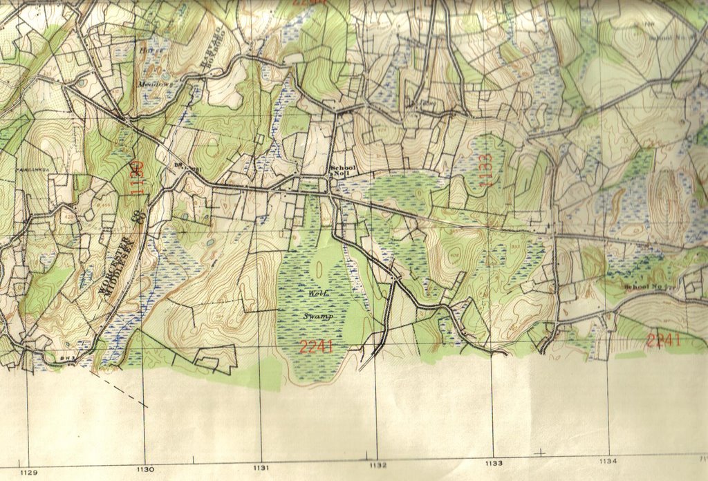
FFC gave me a map he found at the Carlisle landfill - a 1923 topo map of the area around Fort Devens (mayb ~10 miles on either side) that shows all the stone walls. Dan Boudillion first mentioned this map to me and Bruce McAleer had given me some xerox copies but it was nice to get the full map in its original form. It is a fascinating document. For the most part the stone walls form parallelograms or other rectalinear shapes which sub-divide the landscape.
But there are other places on the map where the walls go crazy. Places with pentagonal outlines, diamonds, triangles, little short stretches of wall, bits that follow the natural contours of the hills and wetlands. It is very interesting to note that one place on the map with the most rock piles (as far as I know) is also one of the places where the walls are very irregular. As another example, I was looking over the map and spotted an area of irregularity and though...hmmm...before I realized that that was the place I found a nice site on Dec. 26.
So this observation of a correlation between rock pile sites and irregular stone walls leads naturally to the strategy of searching out on the ground places where the walls seem weird on the map. I practised this strategy last weekend and found a rock pile site - but I probably would have found one anyway in that big a patch of Boxborough woods. I post about that later.
Another thing of iterest on the map is where the stone walls are not. Because those are places where it is too sandy for there to be wall making material. There will not be rock piles there either in most cases. Lately I have been having to drive further away from home to go exploring in new woods and there are two things that can spoil the day: sandy soil and new housing developments. There is nothing more disapointing then driving for 3/4 hours only to end up in a spot with sand and no rocks for walls or rock piles. After that long a drive the day is shot. So now I have a way of screening those places out, t least near Fort Devens: I make sure there are stone walls in the vicininty.
Finally, I think there are other pieces of interesting information hidden in the tangle of lines on this map. I see a number of east-west directed walls. But very few true north-south walls and I am not sure how many magnetic north-south ones. I wonder how many of these walls might line up with a solstice?Note: A i resolution pdf of the map is linked to on the right.
No comments :
Post a Comment