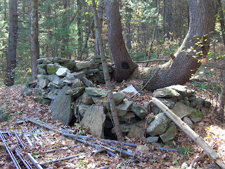
So I went back there to take a look (part of my schedule for hiking near home during the week) and saw two large rock piles, with hollows, surrounded by lots of smaller piles that maybe should be thought of as marker piles. I remember noticing one of these big piles in the past and being specifically confused by it. What was this larger pile and how did it fit in with the much more visible and numerous small piles?
I am pleased that in the intervening 10 years I have learned an answer to this question. It is very routine to find small outliers around large burial mounds in the Wachusett Tradition. They are always there. So the main change between the past and present is the recognition that the large mounds are conceptually, the center of the site, and the small piles are more like attributes associated to these centers. Here are some pictures.
Views of one rectangular mound:


 In this last view, let me highlight the "spine" of remaining structure. In the form of a number "2".
 Obscured by ferns and debris, this is still the typical remnant of a doubly-chambered mound, or a "rock pile with a tail". A first example from Acton. These are comparatively rare in towns around Concord, but appear to get more common further west and north.
Taking a closer look at the first and second pictures, note that there are sort of two layers to the rock pile. A lower layer, made from smaller rocks, projects out beyond the edges of an upper layer made from larger rocks. I do not think those projections are from the smaller rocks tumbling out of place from above. Rather the pile seems to have been constructed in separate layers. This two layer structure was also noticeable in the large pile I saw at Peppercorn Hill (click here for a discussion or here for a video). It makes me wonder about the pile being constructed in two stages where the first stage creates a platform and the second stage builds up a chamber on top of the platform. There was one large chunk of quartz on top:
 Here are some of the smaller piles surrounding this central mound:


 Quite a beautiful scene, on a shoulder overlooking Nashoba Brook from the west.
Here is a view of a second large mound:
 Pretty big, it rises well above ground level:
I explored the woods much more systematically than in the past taking only a few pictures of really fine pile construction. Out at one edge of the site I found a recently constructed sod hut.
 At the opposite edge of the site, someone had re-arranged the stone walls into an enclosure for some purpose - perhaps hunting, perhaps something else.
 So these woods are STILL in use by someone. Call 'em "hobos" to suggest their impermanence or think that maybe they know something we don't; something quite permanent about this place.
2 comments :
This really where I meant to ask the "Is that an outcrop?" question about #7.
Yes I think that is bedrock.
Post a Comment