 and calling attention to places where the rock piles are in lines, and mostly evenly spaced. If there are enough piles it starts to look like a grid - hence the naming of the Acton Grid, Stow Grid, and other places. I also called attention to how often the ground is flat (not necessarily level) and how often the piles would have a clean vertical surface on one side.
Somewhere along the line, I started wondering about shadows cast by the piles and about shadows cast upon the piles by some other nearby feature. I noticed, for example, that the vertical face was usually oriented perpendicular to the line containing the pile. [Saw this at the EMC Southborough site in winter, but I can't find the link.] Also, it seems eminently reasonable to prefer hills with flat sides if you want shadows to move across them at an even speed. Also I wondered if the shadows might pass from pile to pile during the day, or perhaps as the season comes and goes. Now, I think I've found an example that illustrates the principle in a simple way.
So I went walking in Littleton at the Hartwell Family Memorial, which is on the back side of a hill I visited long ago: Proctor Hill. Went up the valley to the north, circled a bit east and then south to the southern sub-summit. Even before I got there I could tell this was the hill's best place to look out over Beaver Brook and the valley with the "Boxborough Esker". And there was a rock pile:
I could see something up hill, on the horizon:
And a few feet to the side, across the hill at the same level was another pile.
(We are looking back towards the first pile). Again, I looked up hill at the other feature there:
Now let's have a closer look at that upper feature above:
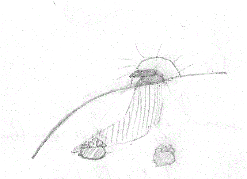
This looks suspiciously like some sort of pointer. Something that would cast precise shadows. Also, if you look at the earlier pictures, you can see this 'pointer' is on the horizon from the point of view of each of the two piles. Here is the view back towards to two piles:
[Look how flat that ground is. Shadows from the pointer can reach anywhere on the slope.]
In these views, we are looking north east. The 'pointer' is to the southwest of the piles and, at sunset, its shadow would stretch down the slope. It is likely that the shadow from the pointer lies at the edge of one or the other rock piles, at some point during the year.
So I think this is what must be going on: As the sun sets, the shadows elongate and sweep across some part of the hill and then vanish.
Maybe the rock piles mark seasonal or daily limits?
Given the configuration of the site, this feels like the correct explanation for the site layout. But these are perfectly measurable effects. It will take someone who can measure these alignments carefully to come out and test the hypothesis. Maybe there is a solstice involved.
There might be a few more rock piles there under the snow? Here is a view from below, back towards the site:
Summary of marker pile features:
Q: Why are the piles evenly spaced?
A: For the same reason measurement intervals are marked out regularly on a ruler, to divide time evenly.
Q: Why are the piles in lines?
A: So they will all be roughly the same distance from the shadow source. Sometimes the lines curve.
Q: Why do the piles have a vertical face perpendicular to the line of the piles?
A: Actually the face is more in line with, and parallel to, the shadow. Presumably for greater precision.
Q: Why does the ground need to be flat?
A: So shadows stretch all the way across a smooth surface, and move at a regular rate over the day and season.
Q: What are these "marker pile" sites for?
A: Marking time, performing a calendrical function.
[Update] Practical Implication: when at a grid turn around 360 degrees and look for a shadow source on the horizon. EG kettle holes and the way the rock piles spiral up from the bottom.
.JPG)
.JPG)
.JPG)
.JPG)
.JPG)
.JPG)
.JPG)


.JPG)
No comments :
Post a Comment