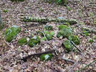
A structure, built across the top of the gully (we are in E. Princeton):
There is a well built gap at the center. Not visible on the right was a continuation of wall, starting with a rectangle with a hollow. So, looking back at the main feature, here is that rectangle with hollow:
The main pile is off to the left in this picture.
Here is a view from uphill:
It is more a "staircase" than a "zigzag". Here is a view from the other side:
Sorry I did not get a better picture of the gap in the middle, or the whole setup from this view over to the far side with the hollowed pile.
***
Somewhere in there I came across what could have been an old foundation or could have been a burial. Don't remember where:
***
Then later (now in W. Sterling), at or around the 4th red outline on that map, I found some old broken down piles that seemed more or less in rows and more or less evenly spaced. What I call "marker piles", which I imagine are akin to a sundial.
The piles seemed a bit triangular. There was an old road nearby, with stones along the side.
And there was a lot going on that was obscured by the decrepitude.
It is unusual and extremely gratifying to find sites like this in Sterling, not too far from that main site I found a few weeks ago
It was heartleaf lilly weekend. With trillium!


No comments :
Post a Comment