Reader Scott sends links:
Sunday, January 31, 2021
Providence Purchase Lands (RI)
I am not quite sure of the exact source for these interesting drawings from Greater
Rhode Island Roaming, accompanied by this text:
“Confluence of the Ponaganset River and the Moswansicut
River - Over the years ... via historical maps ... starting with the Providence
Purchase Lands map by George Matteson.
I was mesmerized by the Providence Purchase Land map.
Numerous spring locations, Indian paths, cornfields, quarry and burial site.
Plus, homestead locations and plot sizes. Crazy detail!! The amount of research
and effort required to build this map would BLOW.MY.MIND! 🙂
Anywho, you'll probably have to save the image onto your
computer to get the best detail.”
https://www.facebook.com/permalink.php?story_fbid=693989634603657&id=271913713477920
Saturday, January 30, 2021
Friday, January 29, 2021
Tuesday, January 26, 2021
Isolated rock stack from Dartmouth MA
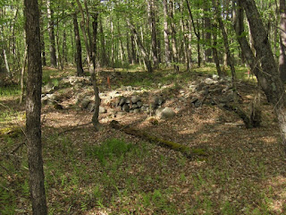
Reader Robert asks if anyone can identify this rock pile. It is isolated and located at the Star of the Sea Reserve in Dartmouth, MA. Specifically, at 41.5909° N / 70.9667° W
Wednesday, January 20, 2021
"We Think These Are Native American"
You Tube of metal detecting near rock piles.
(3) We think these are native American Indian stone piles - YouTube
Mound Designs of Eastern MA
Thought this might be of interest, from an old rejected article:
Variations in outline design of
rectangular mounds with hollows. Styles A-D may be tall and up to 40 feet
across; styles E-H are usually low to the ground and less than ~15 feet across.
Style I is a crescent shape, usually ~20 feet across.
Index
Type A (typical variations in size of rocks used, wall height, and overall size)See figures 2, 3, 4
Blood Hill, Ashburnham
Top of Falulah Brook, Fitchburg
Western slope of Alpine Hill, Fitchburg
Southern end of Mount Elam Road, Leominster
Behind Oakmont High School in Ashburnham
Warren Brook, Upton
Peppercorn Hill, Upton
North Brook, Berlin
Gumpass Pond, Pelham, N.H.
Doeskin Hill, Framingham
Fortune Drive, Billerica
Type B (no known variations, ~25 feet across)
See figure 5
Where West Ashby Road crosses Falulah Brook, Fitchburg
East of water tower in Franklin
See figure 6
Top of Falulah Brook, Ashby
Estabrook Woods, Concord
South end of Mount Elam Road, Leominster
Hopping Brook Development, Hopkinton
Type D (three subtypes: (a) waist high and 15 feet long; (b) as a large outline on the ground; (c) as a small outline on the ground)
See figures 7, 8
Callahan State Park, Framingham (a)
Maxant Land, Harvard (a)
Estabrook Woods, Concord (a)
South end of Mt Elam Road, Leominster (b)
Horse Hill, Groton (b)
West of Route 2, at top of Hobbs Brook, Lincoln (c)
Type E (no variation, ~8 feet across)
See figures 9, 10
Where West Ashby Road crosses Falulah Brook, Fitchburg
Where Richardson Road crosses the brook between Wright Ponds, Ashby
Types F, G, and H (found as outlines or pavements on the ground. They are ~8 feet across, hard to make out and the types blend into each other.)
See figure 13
Nashoba Brook trail off Braeside Ave, Acton
East of Rt 2 at top of Hobbs Brook, Lincoln
Scott Reservoir, Fitchburg
Where West Ashby Road crosses Falulah Brook, Fitchburg
Top of Elizabeth Brook, Harvard
Top of Hobbs Brook, Lincoln
Larger forms of type F
See figures 11, 12
Woodbridge Road, Carlisle
The brook between the Wright Ponds, Ashby
Apron Hill, Boylston
Type I (typical variations in size 10-30 feet, made from small rocks)
See figures 14, 15
Scott Road, Fitchburg
Ballard Hill, Lancaster
Nod Brook, Groton
Horse Hill, Groton
#4
#5
#6
#7
#8
#9
#10
#11
#12
#13
#14
#15 (view downhill)
Tuesday, January 19, 2021
Woods Hole Golf Club Driveway
You see the darnedest things. These bumps have credibility because there is a more undisturbed site in the woods fifty yards away.
Newark Earthwork - from Brad Lepper
From Lepper: Fort Ancient similar but different from the Newark Earthwork (newarkadvocate.com)
Thought I'd show this because - of course! - these were the people who built our rock piles. They used soil because they did not have rocks and, for some reason, they went big.Wednesday, January 13, 2021
'It's Been Erased': Stockbridge Mohicans Retell, Reclaim Their Story In Berkshires
By NANCY EVE COHEN • JAN 11, 2021
A cairn on Monument Mountain, where the Stockbridge
Mohicans left stones in the 1700s. It was looted in 1840 and later
reconfigured.
“The
Stockbridge-Munsee Band of Mohican Indians today are based in Wisconsin. But
their homeland spanned the Housatonic and Hudson river valleys, and stretched
from Manhattan to northern Vermont.
Over the
decades, members of the tribe have come back to the Berkshires to protect
cultural sites…Hiking up Monument Mountain, in Great Barrington, I come across
Chris Graham, and his dog Sophie. I asked if he knows why it’s called Monument
Mountain.
"I don’t," said Graham, who hikes here often. "I know
that there’s the monument at the top of it, the inscribed rock."
That inscription describes the donation of the land to The Trustees.
But the name — "monument" — refers to something left behind by the
native people, explained retired Stockbridge police chief and local historian
Rick Wilcox.
"There is an actual pile of stones or a cairn on the far side of
the mountain. It was along the Indian trail between Great Barrington, Sheffield
and Stockbridge. They would travel by that path and when they went by it, they
would drop a rock on the pile," said Wilcox, on a walk up the mountain.
It’s considered a sacred site. But treasure-hunting vandals looted the
pile in 1840. It was later reconfigured, but it’s not well-marked. Before we
found it, Wilcox took me to the wind-swept summit.
"They call this part Squaw Peak," Wison said.
But "squaw" is now considered a derogatory slur. The
Stockbridge Mohicans have asked the Trustees to change the name to “Peeskawso,”
meaning virtuous woman. The Trustees is doing that, as well as renaming a trail
and adding signage to better reflect tribal culture.
As we descended, Wilcox pointed out the monument — the stone pile,
around 5 or 6 feet tall.
"It’s wonderful to be able to see it. And it’s unfortunate that
it was desecrated," Wilcox said. "You know, so much of their history
has been hidden or wiped out, and so this I guess is in some ways an example of
a piece of their history that was kind of brought back to life."
https://www.nepm.org/post/its-been-erased-stockbridge-mohicans-retell-reclaim-their-story-berkshires
Tuesday, January 12, 2021
Hawaii's "First Ones"
They manage to find rock piles in Hawaii and the Pacific Northwest for comparison. Too bad they did not look in the east.
Upside down Manitou Stone
The sister of a friend writes:
These were taken [In Northhampton MA] around 11:45 am, so the sun is in the south. The front of the stone faces due north (I used my compass).
It's on the north side of a hill, facing downhill toward a wetland area, about .25 miles at the bottom of the hill (See last photo).
Above to the SW is the top of a rocky knoll. And there are many large and small boulders all the around and down the hill -- which is why this whole area is sometimes called "The rocks."
Ruff was kind enough to be my model, for perspective.
As you can see there are now that obvious human-made markings on the face of the stone,but the shape is suspiciously symmetrical.
Sunday, January 03, 2021
Experiencing Stone Rows and Stone Piles at Gates Pond in Hudson, Massachusetts
“Check out possible Native American stone rows and stone
piles in a quick visit to the north end of this beautiful public area and
reservoir in Hudson, Massachusetts. Head into the woods with Mike Luoma and
discover some of the elaborate stonework hiding amongst the trees and along the
wetlands.
Probably the best time to experience a stone row that runs
alongside a swamp is during the winter. The water is low, it's too cold for
insects to be flying around, and the poison ivy isn't so much of a problem.
Mike's suspicions he's found an ancient indigenous stone effigy row are
rewarded by the elaborate work he finds at the end of the row's first length.
Mike believes he's also found an indigenous stone pile, as
described on the blog Rock Piles run by Peter Waksman (rockpiles.blogspot.com).
Mike credits Peter and the blog with early discoveries in stone - and a map of
stone works at Gates Pond Mike memorized for the day's excursion.”
https://www.facebook.com/groups/ancientstonemysteries
Saturday, January 02, 2021
Year in Review - 2020
January:
Invisible mounds in Woods Hole. Here is one. Can you see it?
Concord Mound? X marks the spot
This is a stretch of Rt 62 in Concord, with the Great Meadows to the left and Hanscom Airfield to the right. About at the location of the crosshair, there is a mound of dirt. It is about 12 feet tall above the surrounding ground.
At the time, when I looked at the top of this bump, I thought someone had already been there and dug a hole in the top of it. Now I am not so sure of that interpretation. So for the record: there is a mound in Concord at about that spot. Perhaps someone will go check it out.


