Thursday, July 13, 2006

Bruce McAleer write in about a site in Carlisle

[1st email]
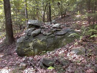
I was doing an appraisal in Carlisle and found a nice drive-by rock pile site. Since you've done so much exploring there it's probable you know the site (since the piles are visible from the car). Go north on *** Street from the town hall. Between ****** Road and ***** Road on your left is a conservation trail into ******. Go about 50 yards north of the trail entrance, which is on your left, and look to your left and you'll see the piles. I only explored about an acre for 15 minutes or so and found about 30 piles. There are some large piles there and some with quartz in the center. I could see more through the trees but left as I was pressed for time. I noticed on the way out that there were piles on the other side of the street as well.


[2nd email]
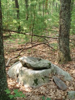
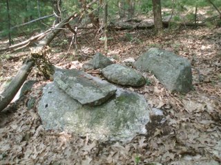
I'm sending a few pictures of some of the more distinct piles from Carlisle. Maybe you'll remember if you've been here. I'll send 3 in this e-mail and 2 in the next. The first photo in this e-mail is a U-shaped enclosure that incorporates a boulder/split ledge. You can see the road in the background. The next photo is the back of the same features showing a large crack filled with rock. The 3rd photo has 2 central quartz pieces (one showing in the center) in a rock pile on a boulder. There is an unusually shaped stone perched on a pile of rock at the base of the boulder.
[3rd email]
The first photo is of one of the large piles. The second is a circular depression about 2 feet in diameter in the top of this pile. Note the stones arranged in a circle around it's perimeter.

Voice of the Turtle - sent in by Tim MacSweeney

Saturday, July 10th, 2004: The Voice of the Turtle
Accessed from web 7/13/06 @: http://peacefile.org/wordpress/?cat=2

(Dated) Monday, July 12th, 2004

“It was an ideal morning for shooting a movie. The air was not too hot, there was some overcast and not much wind. I showed up at the meeting place, the parking lot in Rhinebeck, the same time as Shawna, and Ted showed up three minutes later. We piled into his car and found the site fairly easily. I let him slowly absorb what he was looking at. I said it takes a long time at the site to notice all that is there. Step by step I showed him some of the new discoveries. These were the same as I’d written about for the Saturday entries with Raymundo last week, so I won’t repeat them here.
Ted was pleased. He was really excited about the Shawangunk Conglomerate. He said none of the other sites had exotics, so it was hard to say anything about them. The presence of the Conglomerate might prove once and for all that these were not farmer’s clearing piles.
The three of us worked really well together. Towards the end of the shoot, I we filmed the stone head of the turtle (which I identified as Mullenberg’s Mud Turtle, or maybe a snapper) and I told the Mud Diver story. I used the Munsee words for the four animals in the story: Wusheewayo (duck) squall anhani (bull frog) kwasheesh (muskrat) and t’kwakl (painted turtle). Several times, at the end of the shoot, I referred to the turtle as T’kwakl, Painted Turtle, and spoke that word about four times, loudly. Ted said, “What’s that word again?” TKWAKL.
I ended talking about the painted turtle. As we were preparing to leave, Shawna suddenly said, “Oh my God, look!” and I looked and said “Oh my God,” and said “Ted, you gotta see this! Get over here quick!” He had the camera running and came over and said “Oh my God!” A full sized painted turtle had walked onto the set and burrowed himself halfway into the leaves near a log, less than ten feet from the stone turtle, yet his arms and neck were fully extended, looking at us with great interest. As Ted got up pretty close, and got some headshots, we were speechless! We were trying not to giggle, it was so remarkable. I almost wanted to cry. I said it was a good omen, and told the story of the large turtle that appeared in the center of the circle the day Center for Algonquin Culture was founded.
After a long time, I said to Ted, “You know, I would really like to pick that turtle up and introduce him to the viewers, and hold him up next to the big turtle and show the similarity. He said, “I already had the same thought.” I did so, but instead of coming from behind to give a better camera angle, I kept eye contact with the turtle and approached him face to face. Even when held in the air he came back out to look at us, and we got a close up. I said, “We’re going to have to sign release papers for this guy.” It was a great moment in film. Later, Ted said, “No one’s going to believe this. They’ll think we bought him at a pet store and staged the whole thing.” I said, “If anyone thinks that, they’re pretty sick, and that’s their problem!”
The shape of his back was very much like the shape of the stone turtle. I turned him slightly and showed the camera the 13 moon platelets and the 28 day platelets on his back which I had just talked about. His shell was in perfect condition and the platelets and markings were very clear. Ted also got excellent shots of the Pipsissewa, (also called Winter Green) and not only was it in bloom, but a ray of sun hit it (on an overcast morning) as he was filming. The spirit of the land was very happy today. Shawna also found Indian Pipe. Shawna tenderly placed the turtle back in his burrow in the leaves and he stayed there the rest of our visit, seeming rather interested. Nothing in the film revealed its location. Ted wanted to do topo maps, but later on, over lunch at Schimmy’s, I explained that if we reveal the location it would be destroyed by a particular group almost immediately. A certain man I know saw his son killed on a reservation by native Americans, and he is out for revenge with every breath, sort of like a living Tom Quick.”
And:
Entry for Friday, July 9th, 2004

“I caught Ray at the hotel just before he got off duty at 9 AM…I asked Ray, who honors the environment and the safety of other drivers by owning no car (he has only one eye, so his depth perception is off) if he wanted me to drive him home to catch up on his sleep or go see the Great Turtle of Rhinebeck, which was an hour away. He said he wanted to see the turtle, so off we went…

Chunks From the Beginning of Time

After much walking we found the turtle at the hidden location, and as an Algonquin person, he was quite moved. He said our friend KA had just called yesterday and said she found a stone turtle in Rockland County, and her description of it was similar. Ray noted that there was Pipsissewa growing next to the turtle; a plant associated with the MicMac, used not only for breaking up gall stones but for coughs and sore throats. It has a waxy consistency and somewhat minty. We found some growing elsewhere in the area but it is a northern plant, rare in these parts. Ray said that the Matouac associated it with the Puckwadjee, the ‘little people” of the forest. My mother referred to a mouse, a “little person of the forest” as Pipsissewa in my childhood bedtime stories.
Ray also noted the turtle was surrounded by Pinchot Junipers; we counted ten of them. The presence of Pinchot Junipers adds a great deal to the significance of this spot. The Lenape might have called them “ca-ho-see” or cedar, as a general term, and cedars were planted by the Lenape in places of contemplation “for the benefit of the next generations.” (this is mentioned in Native New Yorkers). However, Pinchot Junipers (and not cedar) produce a grayish berry which the ancient Algonquins used to eat to induce visions. Knowledge of how to use this berry has been lost and it is now extremely dangerous to chew the berry, which can cause death. About ten years ago, a group of young Micmacs who used Juniper without the help of an elder died after chewing Juniper berries. It was in all the papers. There seemed to be four Junipers, in the four directions around the turtle, the largest of which had fallen over. From there several others had apparently spread. This is evidence that the turtle was a place for seeking visions, a dreamers rock! Ray said that his Matouac grandparents on Long Island for example liked to plant the Pinchot Juniper around the outside of the house, not to chew the berries, but just because it is sacred as is the cedar. He said it was a very “Matouac” tree, a tradition which the Wappingers would have inherited.
I pointed to the head of the turtle, and said it looked like a particular type of turtle, the dino-looking one who sticks his head up out of the water with his nose high up. Ray said the turtle head was an accurate depiction of the head of the Mullenberg Bog Turtle, one of the oldest species known. Ray has a Masters Degree in Turtleology from Bogg State University. (Actually, in marine biology from a real university) Bog turtles burrow into the mud, which was most likely the origin of (or inspiration for) the Lenape “Mud Diver” Creation Story. (see www.algonquinculture.org
http://www.algonquinculture.org/ for a sound file of my Munsee/English rendition of the famous tale, mentioned elsewhere in this blog) In that same sub-species is not only the more recently evolved “snapping turtle” but the musk turtle, the eastern mud turtle, and “stinkpot” turtle, all folk names for the same thing. This face seemed to have two sides to it, sort of like the Maysingway.
The back of the turtle suggested a calendar turtle type, (Box, spotted pond etc) a different species than the snapper family which evolved from the bog turtle. So the head represented the creation of the earth and the back represented not only the hemisphere but the creation of the sky.
Then came the most amazing discovery. I showed him the ten or so chunks of what I thought must be quartz built into the structure and lying around. He said it was not quartz but Shawangunk Silurian Conglomerate. I was amazed. I had studied Shawangunk Conglomerate and knew that it could only be found at places like Sam’s Point, over sixty miles away, that it was almost 148 million years old, and very heavy to the heft. He handed me a piece he found on the ground. It was incredibly dense!! I said, “It’s as dense as Kryptonite!” It had reminded me of Shawangunk Silurian Conglomerate, but I thought, “No, that’s utterly impossible!” Apparently it was possible. Ray added that it could be found at Schunnemunk Mountain too, a branch of the lower Shawangunks, also sacred to the Munsee.
The Algonquins knew that heavy rocks were older than light ones, and in fact this is true, as older rocks further down get compressed and then metamorphize into other kinds of rocks. He showed me that this piece was pure conglomerate, a matrix, whereas the milky “beta” quartzite would develop around it.
There were at least a hundred pounds of this conglomerate visible to the naked eye in the turtle. Even today it would take two people with a car an entire day of hard work to carry this much stone from its place of origin to this turtle. It would have taken many Native American people several days to accomplish it in the years before contact. But only the Native Americans would have had the motive for doing so. What exactly was this motive? We don’t know.
This rock only comes from across the river, which is Munsee territory. These are Munsee rocks!! Sam’s Point was some sort of Munsee United Nations Spot, according to my reconstruction theories; there is a council rock there on an abutment which is “an island in the sky” so to speak. That island of rock is covered with chunks of this kind of harder-than-quartz conglomerate, some of the oldest rock to surface. The significance is obviously great, but what does it mean? It has something to do with the creation of the earth and sky, the oldest rock, the oldest turtle…Junipers are ancient trees as well. .Ray said, “Yes! It’s a Ripley’s Puzzle!”
Ray said in Taino (Puerto Rico/Dominican Republic) tradition there is only water until Hurrican creates the turtle and it falls through a hole in the sky, and becomes North America, the first creature to bring mud up from the water. It is the helper through which God parted the waters.
I said maybe this was a sign that we should reunite the old Wappinger confederacy. He joked about how the only Wappingers speakers were either toothless or behind bars. I agreed. We had our work cut out for us, but I suggested it was up to the Wappingers to protect the turtle.

Wednesday, July 12, 2006

MarbH 049 - More camera reviews

Click on this:It is a nice picture and all but...

The pictures I took with the Olympus camera speak for themselves here and in the previous posts about Marble Hill. Every darn picture has got the colors wrong. Even with bright sunlight dappling, it looks as if the sky was faintly overcast or foggy. The dead leaves are always flat and gray, lacking red. The greens are never quite right. Mostly the scenes are flat rather than luminous. Here is an example of an almost overly luminous and colored scene [Click here].
Or this:This one and the previous linked-to picture were taken with HP digital cameras. Both the Olympus and the Nikon have some kind of basic problem with the gamut mapping, so I got curious about what HP is making nowadays and found that the R707 gets excellent reviews. Sample galleries show better color rendering for it than for the other models - except possibly Konica-Minolta, so this may be the deciding factor. I'll cross my fingers and hope it has decent focus and depth of field.

More piles on the back side of Marble Hill

You can follow the path back from Pompositticut School, to the right, and climb the hill and descend to the other side. Part way down on the left is a very minor collection of wedged rocks and a rock-on-rock:
But later when you turn west to go further down the hill and encounter this outline around a boulder, it gets more interesting:The line of rocks curving around to the front and right of the picture is a continuation of a dirt and stone berm/wall/line that continue on for 30 feet or so on the other side of the boulder.

After that you get down into the gully between the two hills which I reported on
[Click here].

Tuesday, July 11, 2006

"Stone Turtle or Drunk Farmer"

[Click here]

Aye, there were rock piles on Sunday too

I hope to get around to documenting them.
What about this poor one, doesn't it look like the upper rocks were just knocked off?

New article by Tim MacSweeney

A new post in "Waking up on Turtle Island" linked to on the right.

Mystery Hill - from James Gage

As some people are already aware, my mother Mary Gage, has been working on a major study of America's Stonehenge / Mystery Hill site in N.H. for the past 4 1/2 years. Her research has culminated in a book length publication, titled "America's Stonehenge Deciphered" which will be published by Powwow River Books (www.PowwowRiverBooks.com ). The book has gone to press and will be available in about two weeks.
For those of you not familiar with the Mystery Hill site, it is composed of a 1 acre central complex of stone chambers, enclosures, niches, drains, basins, and various engimatic stone features. The central complex is surrounded by an extensive stone wall system with scattered standing stones inbedded in the walls. Some of these standing stones are accurate astronomical alignments (summer solstice sunrise & sunset, winter solstice sunset, and equinox sunrise). In addition, there are two cairn fields, a rock shelter, springs and other important features at the site. All together the site encompasses 100 acres. Archaelogical excavations and a large set of C-14 dates from cultural contexts have established a human presence at different time periods for the past 3,000 years. "America's Stonehenge Deciphered" reconstructs the history and evolution of the site from the archaeological record and careful study of the stone structures and other man-made features of the site. It divides the site's history into five distincts phases based upon architectural style of the structures. Detailed and patient study of the stone structures thenselves, revealed important clues about their purpose. These clues provided the means to begin interpreting the site. Piecing all of these small clues together, the book presents a cohesive and persuasive reconstruction and interpretation of this site. The picture which emerges is of Native American ritual complex similar to the sites that many of us are currently researching. The book will offer many new insights and a new perspective for thinking about, analyzing and interpreting other sites.
"American Stonehenge Deciphered" will in all probability generate much debate and controversy. But, that debate for the first time will be about a Native American theory of the Mystery Hill site. A debate long overdue.
James Gage
www.StoneStructures.org

Monday, July 10, 2006

Supported piles from the upper portion of the site in Stow

These have a lot of shape.

Water collection system on Marble Hill, Stow MA

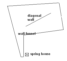
The map fragment of Marble Hill in the previous post indicates a slight concavity of the hill right below where the letter "H" is in "Hill". On the ground, that face of the hill seems to me to have been engineered as a water collection system. The concavity is surrounded by stone walls which funnel water down to a stone lined well or "spring house" at the bottom as shown in this sketch of the walls:

Here is a photo of the nearly parallel walls at the bottom of the "funnel". The concavity in the hill is to the upper left in this picture:
Here is another view a little higher up:
Here is a view of the diagonal wall: And here is the spring house located at the bottom of the funnel: These structures suggest a clever arrangment of wall and well. There is at least one other funnel like this on the hill to the northwest.

The top portion of the funnel, higher up on the hill where the slope begins to level off, is entirely filled with fifty or so rock piles. I have always thought the piles were looking out over the lip of the concavity but actually there are two clusters of piles, one along the lip and another higher on the hill. The piles in the lower cluster are mostly ground piles while, higher on the slope, the piles are more often supported on small boulders. Here are some ground piles:
In the lower cluster is one platform pile:
This pile is larger and might have had a flat upper surface. Perhaps a large portion of the site is visible from this platform. This would be consistent with the idea that piles higher on the slope would need to be taller in order to be visible from a point part way down the slope.

Here is a panorama from up near the top of the site. You can see the piles are pretty closely packed in there and are mostly broken down.
I'll put some other pictures of the piles in the upper portion of the site in the next post.

The gully between the hills - Marble Hill Stow, MA

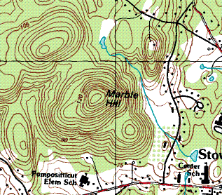
This is a map fragment of Marble Hill in Stow, MA. There are numerous sites on this and adjacent hills, and between them. Look at the gully separating Marble Hill from the next hill to the northwest. I would expect to see a little something in there and, in fact, there where three rock-on-rocks right at the point where the water comes out of the ground and flows off to the southwest.
Noticing the shape of the upper rock, I wonder if this is another example of a "comma"?

It is not too risky to drink water that is coming out of the ground and I did. It was delicious.

Pondering the meaning of "comma" shaped stones

These are from the Marble Hill Conservation area in Stow, MA.

Two pictures of the same thing using the new camera.
Note the parallelism between the support rock and the upper rock. I remember seeing this next one last time I visited the site. I do not think this is the same kind of thing as the "comma" above.
But this next one does seem to be the same idea as the first example above.
I have seen this pattern a number of times before. For example, this one from Flag Hill, a different Stow conservation land:
Seeing this enough times, I think the shape is worth trying to interpret.

Sunday, July 09, 2006

Walks of the Weekend

Saturday I walked at Marble Hill in Stow, and Sunday I explored the Blomfelt land in Harvard. There are new minor sites at both places and a new medium sized site at the place in Harvard. I am still fussing with new cameras - this weekend using an Olypus I borrowed from FFC. It is distracting. Sorry to not be posting more but there will be some new material during the week.

Ceremonies at a Spring

Here we are underneath the hemlock trees at a place in the woods were the slope of a hill has leveled off and water is coming out of the ground in low wet places. These places are often marked by minor ceremonial structures. Like this rock-on-rock.Here is anothe minor feature nearby
Here is another rock-on-rock from nearby. The upper rock may be indicating a direction.

Saturday, July 08, 2006

When a rockpile ceases to be a rockpile . . .

by geophile


Found this quotation today, and I don't remember seeing it on this blog. Seems like it would have been though, so I apologize if it was. Worth repeating, though, and by a favorite author.

"A rockpile ceases to be a rockpile the moment a single man contemplates it, bearing within him the image of a cathedral." ~~~~~~~~~~Antoine de Saint-Exupery

Nice colors

A rock-on-rock from the northwest side of Marble Hill Stow, MA

Friday, July 07, 2006

Until the weekend

Here is a nice scene in Acton.

Interview of an old Medicine Man

01-107: NORMAN MERCREDI - MEDICINE MAN,ASSUMPTION ALBERTA Interviewed by R. Belcourt and Dorthea Calverley

[Click here]

There is a little bit about rock piles but I found the interview interesting. For example:

"...In 1916 they tell that right on that Peace River hill, where Twelve-Foot Davis’ grave is, there were a hundred and fifty teepees. After 1918, there was nobody left. ..."

Turtle Mountain, Manitoba

I think this was linked to before but I realized there was more to the website.
[Click here]
Try some of the links.

Thursday, July 06, 2006

Maybe worth a look

by geophile

A Sky Dome Visualization for Identification of Astronomical Orientations

Here is a link to:
"an abstract on a paper that presents a novel diagram combining archaeological maps with a folded-apart, flattened view of the whole sky, showing the local horizon and the daily paths of the Sun, Moon and brighter stars. By use of this diagram, interesting groupings of astronomical orientation directions, for example, to certain sunrise and sunset points could be identified, which were evidently used to mark certain days of the year.

Orientations towards rising and setting points of a few significant stars very likely indicated the beginning of the agricultural year in the middle neolithic period."

My dial-up was too slow to allow me to download the necessary PDF file, but all of you out there who have computers not powered by dinosaurs pulling a turbine should have no problem. It certainly sounds useful.

Nice picture on the linked page--seems to place the Pleiades, so important and so often overlooked, over the central post.

The ancient stone circle on Rock Pile Moutain, Missouri

[Click here]

Archaeology of Volcan Mountain - San Diego County, CA

[Click here]
And click on the thumbnails.

Symbolism of the flag (of Arkansas)

[Click here]
"...The razorback red silhouette of the ...State of Arkansas shows her capital, the City of Little Rock, represented by the centered star. The star rises directly above "Little Rock" [the mound or rock pile] ... protruding cliff along the Arkansas River..."

Next day out in Falmouth, MA (July 4th in the morning)

by pwax
On my third day out in Falmouth looking for new rock piles I went to the northern side of Beebee Woods, and walked south and west from the trailhead on Ter Huen Drive. I did not see much till I got to a substantial pond which I believe is the "Punch Bowl" and turned back north/east on a trail. Not too far along and there was a clear rock pile in the middle of the trail:
There were a few very faint traces of other structures nearby. For example this loose line of dirt and cobbles leading to a small boulder:
I looked all around for other things and saw a couple of what seemed like more recent rock-on-rocks nearby. They seemed recent because the rocks had no lichen and were placed precariously in a way I would assume would be damaged after not too long. Is this simple "wannabe" stuff or genuine recent ceremonialism? This question seems to come up over and over in Beebee Woods. There has been enough time since Mavor and Dix wrote about the woods, for people to go out and mess around. However one place where I lifted the "recent" rock off of its support, it seemed clear that some amount of time had gone by because there was a stain on the lower rock.

Continuing along the same trail just before it crosses a stone wall there is a knoll a few feet to the north of the path with a wonderful "turtle pile". I'll show you in a moment. But here also there was at least one nearby feature that looked more recent:
That little rock propped up in the split does not seem quite right. And close examination made it seem relatively recent. If I had to say, these "recent" features are about as old as the rock piles I found near a tumbled down cabin in the woods which I took to be from around 1960. So that is my estimate for when these"recent" features were made.

Anway, here is a "turtle" a little beyond the pile-in-the-trail and before the stone wall:
This pile is about 8 feet long with the head facing southwest along the left side of a valley that starts here. This is an example of "Turtle Piles - Version 3" [Click here] I believe this is a straightforward identifiable type of structure. Examples are known from the Cape, Foxborough, Acton, Littleton, and Stow. The Littleton example, on the corner of Fort Pond and Nagog Hill Roads, is so much associated with Sarah Doublet Forest, that it is hard to dis-associate it from the most recent Indians who are known to be have lived there in historic times.

I looked around and noticed the recent ceremonialism (shown above) and continued by following the stone wall uphill. At the top it met another wall which led to some extremely non-Indian type rock structures.
The second picture shows one side of a stone outline made from rocks borrowed from the wall. To the left in the picture is the campfire and to the right is some sort of seating and/or altar. Both suggest multi-person activities. Doesn't resonate with rock piles. From there I made my way out.

Meniolagomeka

by geophile


I'm amazed by the vision of those who came before.

I've never posted anything about the site in Monroe County called Meniolagomeka, partly because I have only this unsatisfying photograph and partly because I didn't fully understand its significance.

This site was once a Lenape (Delaware) Indian village, eventually converted to Moravian Christianity. The Moravians were notable, among other things, for being willing to learn the Lenape language, and one who ministered to the Indians at Meniolagomeka actually translated the gospels into that tongue. A group of Moravian Delawares still exists in Canada.

At any rate, an unusual wall complex remains on the site, which is marked by a monument placed by the Moravian Church. Two broad walls come together at an acute angle, forming a closed-in space, but on the inside of one of those walls, it comes to a point. This is hard to describe. This was also the first place where I saw a 'thunderbird nest' or hollow in one of the broad walls. Whether this is significant, I don't know,but when we visited there with the Lenape descendants who joined us for the conference, they chose to settle and talk at this hollow place in the wall.

In the picture above, you see Fred Werkheiser pointing out a feature in the wall. Note the dug-out places on the rock in the background.

The most interesting memory I have of this place, however, was a visit we made to it on winter solstice. We stood at the place where the wall came to a point inside the area enclosed by the meeting walls. The sun appeared about to rise in a deep notch in the Kittatinny Ridge, but then, instead of rising clear, it crept along, just hidden by the edge of the ridge where it rose from the notch. You could see that the sun was there because its glow moved along the ridge, but it didn't actually rise until some minutes later, when it got up to where the ridge flattened out. It was a memorable effect.

This site was not as impressive as those that include strikingly representative boulders or unusually-shaped rock piles, but it has increased in its significance for me since I have learned more here. If possible I will try to get more pictures there one of these days.

Wednesday, July 05, 2006

Reader "Highland Boy" writes in about King Phillip's Rock

These are from an area near King Phillip's Rock as described in my recent blog entry. I've had a blog up for awhile, but not much time to add to it. You can have a look here:
http://highlandboy.com

Chatting with James Mavor - co-author of Manitou

I caught up with Mavor at the 4th of July parade in Woods Hole, MA. I wanted to ask him specifically about how the idea first got started that the Indians were the creators of the stone features we find in the woods. I am afraid Jim is not well and is going back in for more chemotherapy. Anyway he seemed pleased to chat and I hung on every word that I could hear over the sounds of the surrounding crowd. So here is what I can remember of the conversation:

I reminded him he had told me his interest began with Alexandre Thom and the desire to apply archeo-astronomy techniques to the stone walls in New England. Mavor confirmed that was so. I asked him how he met Byron Dix, the other co-author of Manitou, and he said it was all in the book. I asked if the idea of Indians came from Byron. He said that Byron had fallen under the influence of Barry Fell [author of hugely controversial books about European contact with America before Columbus] - who was urging Byron to come out and do some astronomic observing. Mavor said Fell was a very dynamic and aggressive individual and Byron "suffered" for it - I think this meant Byron's reputation suffered from being associated with Barry Fell. Mavor also said that Fell was a genius. Anyway, Mavor talked some more about Giovanna [Peebles] the Vermont State Archeologist and how she wrote a book "debunking" the whole stone chamber business. Mavor and Dix wrote two rebuttals to her book, published in Vermont Archeology, and apparently those rebuttals are not well known. I also asked: what about Mark Strohmeyer? He said Strohmeyer came a lot later.

Coming back to the question: When did the idea of Indian stonework first come up? Jim's first words were: "it came up when we excavated at Calendar I". I did not get him to elaborate but asked him: What about Ted Timreck? Ted claims he suggested Indians to Mavor and Dix. Now Mavor said: he did not remember Ted introducing the idea "as such" but Ted was at the dig in Calendar I. They did a number of excavations there. This leaves open the possibility that Ted was the one who first mentioned it. Mavor said about Ted: he has an amazing ability to get Scientists talking who usually would have nothing to do with each other. So there you have it: if anyone is responsible it is Timreck for suggesting the idea in a context provided by Mavor and Dix's excavation at Calendar I. Ted Timreck is a freelance film maker who does work for the Smithsonian. Mavor also credits Ted with first getting the scientist talking about the possibility of a Solutrean - Clovis connection.
Here is Jim with a piece of watermellon. He is sitting in the "Waterfront Park" which he helped to design to incorporate major skywatching directions over carefully placed small rocks.

Update: I did not mean to imply I thought Ted Timreck was soley responsible for the idea of Indians being the creators of the stone structures. Rather the idea seems to have come out of an interaction between several individuals at a certain point in the events described in Manitou.

Random "cairn" photos from FLIKR

[Click here]

[or here]

[or here]

Tuesday, July 04, 2006

Wedged Rock - Beebee Woods, Falmouth MA

Pedestal'ed Boulders from Larry Harrop

Larry writes in:
I found this boulder a couple of weeks ago but was unable to get under it to see what was there. I knew there were some rocks under it that seemed to be supporting it. This morning, I was able to investigate it further and confirmed that it is lifted off of the bedrock. What makes this interesting is the fact that less then 100 yards away is this pedestaled boulder that I found last winter.

[Click here for the example from last winter]

[Click here for the new one]

Monday, July 03, 2006

Next day in Falmouth, MA

Only one more pile today - along with a good workout.This one is from north of T. Landers Rd, on the right hand side of the conservation land.

Sunday, July 02, 2006

First day out in Falmouth, MA

by pwax
Found one pile today:

This is north of Brick Kiln Rd - somewhere behind the high school. I doubt I could find the place again.

Excavators use nature-friendly techniques to probe sacred ground

[Click here]
Link via Archeologica

Chambers and root cellars

by geophile


A common phenomenon near where I grew up in eastern Pennsylvania is the stone root cellar or chamber. Many are disappearing as properties are sold and new houses are built. Since most of them show at least some mortar between stones, it's hard to say when they were built or who built them. Here are two examples, both near streams. The first one, in particular, is in a very low, wet place not a great place for storing root vegetables.

It is at the base of a hill called the Spitzenberg, which has geology so unusual that college geology classes take field trips to it and it is labeled the "Hamburg anomaly" on geology maps. Stone walls are almost entirely absent from the landscape here, but Fred noticed a wall running down the slope of the Spitzenberg, and asked the farmer living there whether there were any old stone structures around. The farmer said, "Well, there's a kind of funny root cellar down there . . . "

I have not been back with a camera, but a friend and I wandered around on the Spitzenberg one day and found some small rock structures.
The second chamber pictured here is not far away from the first, near the base of what local people call the Pinnacle, a place where the Kittatinny Ridge comes to a point, the highest elevation locally, with a large rock outcropping and a well-known, now destroyed, cave. A local legend told of a dragon that flew from caves on the Spitzenberg to the cave on the Pinnacle. There was more, about a tragic young Indian couple. A storied area, at any rate. Whether the chamber/root cellars are connected to any of that I don't know.

What's odd is that people don't think about preserving these things, even if they were just built by German ancestors. They are extraordinary and beautiful structures.

Saturday, July 01, 2006

The Miner Farm, Hopington RI - a new album from Larry Harrop

[Click here]

Blogging slowdown over the Holidays

Family events, travel, lack of internet connection, and less opportunity for exploring are going to make this a slow week.