 And it occurs to me that another rock-on-rock [Click here] is also of that shape.
Thursday, July 20, 2006
Other "cashews"
Talking about comma-shaped rocks and boad rudder-shaped rocks [Click here]. I came across this other example from the Conant land in Carlisle: And it occurs to me that another rock-on-rock [Click here] is also of that shape.
 And it occurs to me that another rock-on-rock [Click here] is also of that shape.
Wednesday, July 19, 2006
Damaged Piles in Leominster State Forest
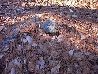
I want to take a closer look at the damaged side of the last pile described in the previous post: 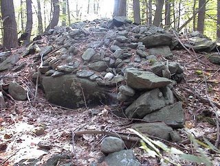 Note the larger rocks. Note the isolated piece of quartz. This is the only quartz I saw anywhere in any of the piles at this site. So it seems special and at first I thought this hollow with the larger rocks in back and to the side was a niche - perhaps for sitting and looking out. But now it looks more like the destination for the damage. This leads to wondering if the Leominster Historical Society has an artifact collection?
 Note the larger rocks. Note the isolated piece of quartz. This is the only quartz I saw anywhere in any of the piles at this site. So it seems special and at first I thought this hollow with the larger rocks in back and to the side was a niche - perhaps for sitting and looking out. But now it looks more like the destination for the damage. This leads to wondering if the Leominster Historical Society has an artifact collection?
West of Leominster - between the hills
I planned a walk with Joe, my youngest son, to go up one of the hills you see from Rt 2 as you drive west towards Fitchburg. These hills form the west side of the valley of the Nashua River and are the eastern foothills of Mount Wachusett. Most of this area is Leominster State Forest, a dark and gloomy place shut off by thick undergrowth of Mountain Laurel. Two years ago I started exploring Leominster State Forest as part of an experiment where I would pick a spot on the topo map, go there, and try to find rock piles. For the most part the experiment succeeded, more or less, except for a number of places where my efforts were thwarted by not being able to get through the Laurels, which can grow so densely that they are impenetrable. It is an area I am a bit afraid of.
There are a lot of rock piles in Leominster State Forest and it is a good study area as it has been little disturbed in recent times. I am told that it was an area with pestilence houses, an area that was never really farmed but was used as woodlots, as a place for charcoal manufacture, a place for pastures. There is a thin layer of soil over bedrock and glacial till - soil a plow would never be able to get through. Anyway, looking at the topo maps, I picked a place in there with a wetland between some summits and a dirt road nearby - so we would have a chance of being able to get there on foot. It turns out that these eastern hills of Leominster State Forest are not quite so dense in Laurel and a bit easier to navigate than the ones I explored in the past. So actually my son and I had a pleasant walk, but a short walk because I forgot to bring water.
So up we went on a hot day, driving as close as possible, parking, and walking in on a dirt road through the forest. Hot and muggy in the woods but with a fresh breeze on the hilltops. My plan was to explore a few hilltops and around the wet places in between. Before we even got to the first hilltop there were a couple of large "mounds" which I did not think were ceremonial:
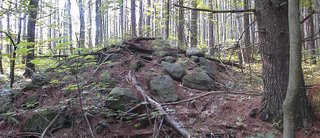 They were not too well made, with different sized rocks, and they were near a power line where I think there must have been plenty of earth moving equipment. Also the piles were isolated and so I wrote them off as something other than ceremonial. A few feet away, under the power lines, was a quarry and another large loose pile which looked like debris from the quarry - another reason for discounting these as Indian piles.
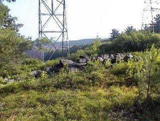 A bright, sunny, humid, breezy day. The view here is facing north and northwest. Later we found a site with large mound piles and, in retrospect, I think these first piles are part of the same general site. In the end I concluded these were probably ceremonial.
From here we continued up and over one of the hilltops and then went back down towards the valley between summits. There were a few minor things in a water break-out zone, a rock-on-rock here, a split-wedged rock there; and then we are continuing along the dirt road and there was a place where a small side road came in from the right following a stone wall. The wall had a bulge in it which looked suspiciously like an old rock pile, so I asked Joe if we could take a little detour down the side road, and when we did we immediately came to a low flat wet area with some other big mound piles. This was very close to the place I had hoped to get to when studying the topo maps. Here was the first glimpse:
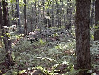 And here is a closeup of the first pile.
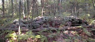 Note the suggestion of internal structure in this picture. A bit of vertical walling to the right, and a bit of a hollowed out nest to the left.
While taking the photo I became aware of other large piles looming in the background:
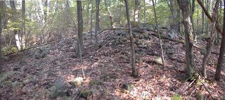
 In the end there were about six of these large piles around a small wet area which fed into a larger wet area which, in turn, developed into a brook which was the headwater of one of the major brooks in the State Forest, flowing down into the lowlands where there were mills and such. In fact this first minor wet area was just adjacent to a watershed divide such that, a short distance away, the brooks flow in the opposite direction. So this is at the start of two different brook systems, nestled in a level spot between hilltops.
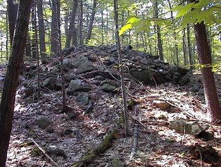
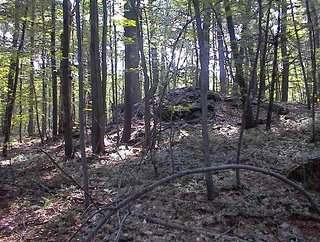
At this point my son was thirsty and after continuing a short ways we turned and started back along the dirt road. A few paces along and there was a small hill we had passed on the way in, and I asked Joe if I could "pop over there" just to check the hilltop. It was a good thing I did because there was one more large "mound" at the top, directly above the low place with the other mounds:
 Here is the view back towards this mound from a short distance away:
 In the end we explored a very small portion of the woods, mostly just along the forest road we had been following. This makes me wonder what lies a bit further along? Are there mounds like this everywhere in there, just hiding behind the Mountain Laurel?
There is a lot more woods to explore but I suspect the wet place and brook, and watershed divide, and view out over the wetland to the northwest and, in the other direction, to the northeast all play a role and make it most likely that the site would be here instead of somewhere else. I am guessing further explorations will not be so fruitful and needs to concentrate on similar topography. As a rule of thumb when you go to explore a new place, you cannot assume the sites will be where you would expect them. But once you have found a site, other sites nearby are most likely to be in similar topographical settings - similar elevation, viewing direction, relation to water, etc.
Note that I am calling these large piles "mounds". They do not have retaining walls and have little external structure. They do not seem to be platforms. These are big piles (20-30 feet across). Where have we seen something similar? The closest I can think of is the large piles along the Hobbs Brook in Lexington and Weston. Maybe there is no comparison but I was thinking of Whippile Hill.
In a couple of the pictures, one sees the suggestion of structure within the piles. Looking at all of the pictures I see that every one of the piles is badly damaged and was cratered on one side near the top. It is within this "crater" that I am thinking I see a bit of internal structure. For example, that last pile really looks like it might have had a small inner chamber that was breached by the damage. We'll take another look at this in a moment.
There are a lot of rock piles in Leominster State Forest and it is a good study area as it has been little disturbed in recent times. I am told that it was an area with pestilence houses, an area that was never really farmed but was used as woodlots, as a place for charcoal manufacture, a place for pastures. There is a thin layer of soil over bedrock and glacial till - soil a plow would never be able to get through. Anyway, looking at the topo maps, I picked a place in there with a wetland between some summits and a dirt road nearby - so we would have a chance of being able to get there on foot. It turns out that these eastern hills of Leominster State Forest are not quite so dense in Laurel and a bit easier to navigate than the ones I explored in the past. So actually my son and I had a pleasant walk, but a short walk because I forgot to bring water.
So up we went on a hot day, driving as close as possible, parking, and walking in on a dirt road through the forest. Hot and muggy in the woods but with a fresh breeze on the hilltops. My plan was to explore a few hilltops and around the wet places in between. Before we even got to the first hilltop there were a couple of large "mounds" which I did not think were ceremonial:
 They were not too well made, with different sized rocks, and they were near a power line where I think there must have been plenty of earth moving equipment. Also the piles were isolated and so I wrote them off as something other than ceremonial. A few feet away, under the power lines, was a quarry and another large loose pile which looked like debris from the quarry - another reason for discounting these as Indian piles.
 A bright, sunny, humid, breezy day. The view here is facing north and northwest. Later we found a site with large mound piles and, in retrospect, I think these first piles are part of the same general site. In the end I concluded these were probably ceremonial.
From here we continued up and over one of the hilltops and then went back down towards the valley between summits. There were a few minor things in a water break-out zone, a rock-on-rock here, a split-wedged rock there; and then we are continuing along the dirt road and there was a place where a small side road came in from the right following a stone wall. The wall had a bulge in it which looked suspiciously like an old rock pile, so I asked Joe if we could take a little detour down the side road, and when we did we immediately came to a low flat wet area with some other big mound piles. This was very close to the place I had hoped to get to when studying the topo maps. Here was the first glimpse:
 And here is a closeup of the first pile.
 Note the suggestion of internal structure in this picture. A bit of vertical walling to the right, and a bit of a hollowed out nest to the left.
 While taking the photo I became aware of other large piles looming in the background:

 In the end there were about six of these large piles around a small wet area which fed into a larger wet area which, in turn, developed into a brook which was the headwater of one of the major brooks in the State Forest, flowing down into the lowlands where there were mills and such. In fact this first minor wet area was just adjacent to a watershed divide such that, a short distance away, the brooks flow in the opposite direction. So this is at the start of two different brook systems, nestled in a level spot between hilltops.
At this point my son was thirsty and after continuing a short ways we turned and started back along the dirt road. A few paces along and there was a small hill we had passed on the way in, and I asked Joe if I could "pop over there" just to check the hilltop. It was a good thing I did because there was one more large "mound" at the top, directly above the low place with the other mounds:
 Here is the view back towards this mound from a short distance away:
 In the end we explored a very small portion of the woods, mostly just along the forest road we had been following. This makes me wonder what lies a bit further along? Are there mounds like this everywhere in there, just hiding behind the Mountain Laurel?
 There is a lot more woods to explore but I suspect the wet place and brook, and watershed divide, and view out over the wetland to the northwest and, in the other direction, to the northeast all play a role and make it most likely that the site would be here instead of somewhere else. I am guessing further explorations will not be so fruitful and needs to concentrate on similar topography. As a rule of thumb when you go to explore a new place, you cannot assume the sites will be where you would expect them. But once you have found a site, other sites nearby are most likely to be in similar topographical settings - similar elevation, viewing direction, relation to water, etc.
Note that I am calling these large piles "mounds". They do not have retaining walls and have little external structure. They do not seem to be platforms. These are big piles (20-30 feet across). Where have we seen something similar? The closest I can think of is the large piles along the Hobbs Brook in Lexington and Weston. Maybe there is no comparison but I was thinking of Whippile Hill.
In a couple of the pictures, one sees the suggestion of structure within the piles. Looking at all of the pictures I see that every one of the piles is badly damaged and was cratered on one side near the top. It is within this "crater" that I am thinking I see a bit of internal structure. For example, that last pile really looks like it might have had a small inner chamber that was breached by the damage. We'll take another look at this in a moment.
Stone Mounds at Fort Ancient Ohio
"...These mounds dot the entire landscape inside the "Fort"...."
[Click here]
[Click here]
Tuesday, July 18, 2006
A small "calendar" site in Boxborough - from Journals (2004)
...near the top saw a disturbance of the soil and rocks which I thought at first was a perc test pit but saw was a little break out zone and there were inconspicuous pile there. First a photo taken standing on a larger low rock, viewing up the wet spot, roughly northwest, towards the horizon:
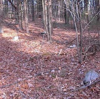 You can see a pile to the right foreground, a rock to the left, a rock-on-rock in the midground, and another in the background a bit to the right. Here are some of those details:
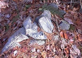
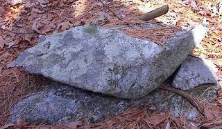
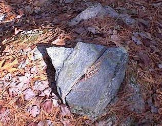 That direction of view uphill from the rock is -say- northwest. Then I noticed, in a somewhat perpendicular direction east and/or southeast, there was a smidgen of an alignment also visible from the rock where I was standing:
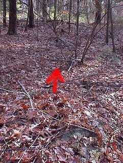 There is a "downhill" horizon in that direction. Seeing this possible alignment, suggested I was coincidentally standing at a designed central viewing point, and also suggested a different meaning for what I was viewing uphill. The pile, rock, rock-on-rocks in the uphill direction were not all in a line. I had been photo'ing them to get a sense of their context. But after seeing the alignment in the other direction, it made me wonder if perhaps these detailed, non-aligned features might have marked various horizon directions also....
 You can see a pile to the right foreground, a rock to the left, a rock-on-rock in the midground, and another in the background a bit to the right. Here are some of those details:

 That direction of view uphill from the rock is -say- northwest. Then I noticed, in a somewhat perpendicular direction east and/or southeast, there was a smidgen of an alignment also visible from the rock where I was standing:
 There is a "downhill" horizon in that direction. Seeing this possible alignment, suggested I was coincidentally standing at a designed central viewing point, and also suggested a different meaning for what I was viewing uphill. The pile, rock, rock-on-rocks in the uphill direction were not all in a line. I had been photo'ing them to get a sense of their context. But after seeing the alignment in the other direction, it made me wonder if perhaps these detailed, non-aligned features might have marked various horizon directions also....
Another site in Carlisle
This site was mentioned by Bruce McAleer a week or so ago [Click here]. He and I went to take a closer look at it last weekend and, as I suspected, this is a site I have been to before. I know someone who played here as a child and who remembers building "stone forts". It is clear that he used material from the numerous piles in the area. There are 20 or so piles on a gently sloping acre, facing westward and leading down to a wetland. Most of the piles are built on supports and most look damaged.
Here is Bruce looking at a pile. He had just finished pointing out an isolated piece of quartz in the pile.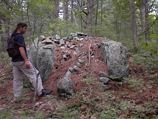
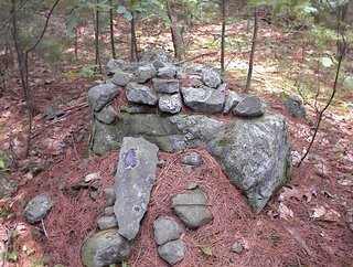 A friend of the friend (who played here as a child) is camping in the woods there.
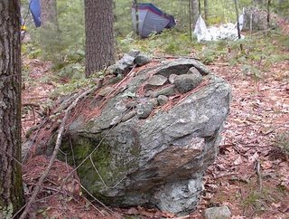 I had not visited this site recently. One thing Bruce pointed out was a shoulder above the wetland, the last bit of slope, consisted of one or more long rock piles - almost the whole shoulder was made of rock pile.
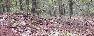 To me this is the most interesting feature of the site.
Here is Bruce looking at a pile. He had just finished pointing out an isolated piece of quartz in the pile.

 A friend of the friend (who played here as a child) is camping in the woods there.
 I had not visited this site recently. One thing Bruce pointed out was a shoulder above the wetland, the last bit of slope, consisted of one or more long rock piles - almost the whole shoulder was made of rock pile.
 To me this is the most interesting feature of the site.
Conant Land in Carlisle
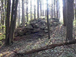
This site was published in newspapers several years ago, so under the "guidelines" it is OK to say it is located behind Carlisle Town Hall. The woods back there consist of small ups-and-downs with water in the low places and evidence of past water flow management - dams and ditches. The whole area has a combination of rock piles and modern structures such as sculptures, petroglyphs, and fake cup-and-ring marks. It is a free-for-all and, by now, a thoroughly corrupted site. You would think, for example, that after the extensive discussion this site received in the local press (The Carlisle Mosquito) that they would police the creation of fake petroglyphs back in there.Some of the piles have been torn apart. Anyway in one place, the piles are still in good shape and rise dramatically above the ferns - built up as cairns supported on boulders.


 These piles have a recognizable characteristic: they are well built stacks with a vertical wall on one face. However one of the piles (2nd from the top) looks a bit like a turtle: it has a pointed "tail" rock sticking out in back and a "head" drawn into a "plastron" opposite of the tail. [These features are not shown in the photograph.]. One question is: would a pile be shaped like a turtle but at the same time designed for a specific function (I assume an astronomical function since the vertical walls would seem to relate to lines of sight)?
At any rate, they are nice looking piles. There are a few more I did not illustrate, and the whole area is accessible and worth exploring. It is a five minute stroll down from the parking lot.
Monday, July 17, 2006
A small boulder group site south of South Shaker Rd, Harvard, MA
Across from the "Holy Hill Conservation Land" parking lot, on the south side of South Shaker Rd is another trail leading south into the woods. I went in there and explored a bit to the left of the trail. About 100-200 yards in, down near the wetland, was a boulder group with rock-on-rock, and a few noticeable alignments.
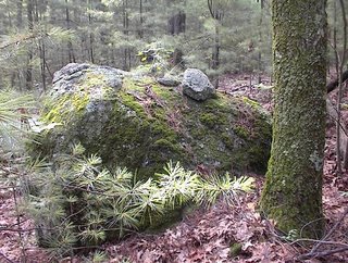
Here is a rock-on-rock with the boulders in the background:
 Here is a cluster of rock-on-rocks:
 Here is an alignment which incorporates rock-on-rocks:
 So this is an east facing site, on the final gentle slope down to a wetland.
One more picture from this site shows a pair of rocks on a support, which I call "Twins".
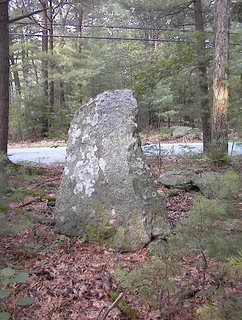
 Notice the distinctive shape of the rock on the left, somewhat paralleled by the shape of the rock on the right. The shape is a bit like a boat rudder and I believe it is a variation on the "crescent" or "comma" or "cashew" shaped rock we were discussing here last week.
Here is a rock-on-rock with the boulders in the background:
 Here is a cluster of rock-on-rocks:
 Here is an alignment which incorporates rock-on-rocks:
 So this is an east facing site, on the final gentle slope down to a wetland.
One more picture from this site shows a pair of rocks on a support, which I call "Twins".
 Notice the distinctive shape of the rock on the left, somewhat paralleled by the shape of the rock on the right. The shape is a bit like a boat rudder and I believe it is a variation on the "crescent" or "comma" or "cashew" shaped rock we were discussing here last week.
Trying to find Shaker Mount Zion or "Holy Hill"
 Since I have been exploring in the "Shaker" parts of northeastern Harvard, I looked up what Mavor and Dix had to say about the area. On p.290 of Manitou they write about a number of features on what they call "Mount Zion" and show a little map which corresponds with the north-south-elongated hill on the right side of the above map fragment. This area is a Harvard Conservation land with a parking lot on the north side of South Shaker Rd. So I parked there, examined the trailhead map and then set out. Apparently I headed in a slightly wrong direction cuz the hill I explored had none of the features they described. I still cannot figure it out because it is as if I was on the little hill to the left up and to the right of the word "SHAKER" on the map.
Anyway, I did find some minor piles and other things, whichever hill I was on. Starting a few feet in from the trailhead, on the left, there was a pile with an unbroken cream/milk bottle at its center:
 And then I found a number of examples where colonial or farm related items were placed within the rocks. With apologies about the poor photo quality, here is a split "wedged" rock incorporating a folded rusty piece of iron.
 When I saw this I thought "Hmm, Shakers.....the first wannabes". I was getting the feel of white people running around pretending to be Indians but doing it in a ham-fisted way. It seemed like every other split rock was wedged with one or another piece of farm related junk. Continuing with this line of fantasy, I imagined the real Indian shamans being only too willing to take advantage of rich translanted Europeans playing at Indian spirituality.
As I edged up the hill, following a "Yellow Spot" trail, there was no sign of what M&D call a "Cleared and levelled area" and I did not find the other things at the hilltop which they described. Instead I found a large tumbled down pile on the north western side of the summit.
 Then coming back south at what I think was the high point there was this little circular pile:
 Probably the most substantial rock piling I saw was a little shrine type thing in the woods: a couple of rock piles near a stone wall at the eastern base of the hill, with a short line of steps leading part way up the hillside:
 At the top was a 10x15 foot level spot with a back wall made as a nice rock pile:
 I continued having a slightly negative reaction to these out-of-place non-Indian features.
 Aside from a few other minor low ground piles downhill from the path on the eastern slope of the hill, this was all I saw. So I went back to the parking area, crossed to the south side of S. Shaker Rd. and continued exploring over there.
Sunday, July 16, 2006
Previewing weekend finds - Shakers, Cairns, and Mounds
Klamath Vision Quest
"...He runs about constantly throughout the night, piling rocks into high piles... and swimming in the mountain pools."
Thanks to Bruce McAleer for the link.
[Click here]
Thanks to Bruce McAleer for the link.
[Click here]
Saturday, July 15, 2006
Devil's Tombstone, Greene County, NY
by geophile
Someone brought this one to my attention. It's listed thus:
" Natural rock formation resembles a large tombstone."
Check out the fifth photo down here.
See how natural you think it is. Looks like a standing stone to me.
While you're on that page, check out the one that's fourth down in the second column. It may be just the angle of the camera in this case, but the rock face looks kind of like, well, a rock face.
Snippets From A Primary Source
by JimP
John Josselyn twice spent time on his brother's land in Black Point, ME -- in 1639 and 1663. From his writings it's obvious he had an almost daily relationship with the Native people who lived there. Because he was not a Puritan, his books have an entirely different flavor from most primary sources. For the most part he was a naturalist and a tourist, and writes from those angles.
There are two quotes from his works that I think are important clues concerning Native spirituality and rocks around the time of first contact. I haven't seen these quotes mentioned at all on any of the usual sites, so I thought it would be good to post them -- especially considering all the split-wedged and split-filled rocks that we see in photos here.
"And I have heard it reported from credible persons, that (whilst I was there in the Countrie) there happened a Terrible earthquake amongst the French, rending a huge rock asunder even to the center, wherein was a vast hollow of an immeasurable depth, out of which came many infernal spirits."speaking about the work of Medicine Men in healing the sick:
"if the sick recover they send rich gifts, their Bowes and Arrows, Wompompers, Mohacks, Beaver skins, or other rich furs to the Eastward, where there is a vast rock not far from shore, having a hole in it of an unsearchable profundity, into which they throw them."
Friday, July 14, 2006
Check Highland Boy's blog
I added a link to Highland Boy's blog to the right. He is updating it regularly so you should check occasionally for new content.
Thursday, July 13, 2006
Speaking of Stone Turtles
by geophile
 It's funny how things jog your memory. A few years ago I took a roll of film, not realizing it was black and white. I hadn't taken the pictures with that in mind and most of the subject matter did not come through well, so I set it aside. All this talk of stone turtles, though, got me thinking and I got it out to check. These three photographs were taken on a property owned by the electric company. Some of the trails run along a bluff above the Delaware River, including above some very risky rapids referred to as the Foul Rift.
The first time I went there, it was on a tour to look at the very old trees that remain there. The guide stopped at this rock outcropping and pointed at the feature in the first two photos. He said we would probably think he was seeing things but it reminded him of the head of a turtle. He had brought his young son out to sit on it and have his picture taken because of that resemblance.
 I could see the turtle, but I thought that looking at it differently it looked like a bird's head, too, especially a crow's. This looks like it is a split wedged rock.
The rock outcroppings here were all very interesting. And at one place where people obviously sit to look down at the river, there's a rock that appears to be carved. My son has been after me to get a good picture of that, and I'll have to.
When I went there that first time, many rocks on the trail that went along the river had chunks of black chert in them. I was amazed to see how much of it there was. Unfortunately, on subsequent trips, I've noticed that someone has come in and taken it by chipping it off the rocks where it stuck out, and just taking the smaller rocks. I would think the presence of the chert gave the place a special value in the eyes of the First People.
Here's another feature I noticed there. I will probably notice more nex time I go, as this blog has opened my eyes to some things.
 The plants at this place were also noteworthy. Wildflowers that are growing less common still bloom there, and a locally rare fern, the walking fern, creeps over the rocks. One spring we harvested some luscious mushrooms there as well. I don't pick many mushrooms, but this was a kind I was certain of. On either side of the road we drove in on, osprey nests could be seen at the top of the huge pylons. Nice spot.
 It's funny how things jog your memory. A few years ago I took a roll of film, not realizing it was black and white. I hadn't taken the pictures with that in mind and most of the subject matter did not come through well, so I set it aside. All this talk of stone turtles, though, got me thinking and I got it out to check. These three photographs were taken on a property owned by the electric company. Some of the trails run along a bluff above the Delaware River, including above some very risky rapids referred to as the Foul Rift.
The first time I went there, it was on a tour to look at the very old trees that remain there. The guide stopped at this rock outcropping and pointed at the feature in the first two photos. He said we would probably think he was seeing things but it reminded him of the head of a turtle. He had brought his young son out to sit on it and have his picture taken because of that resemblance.
 I could see the turtle, but I thought that looking at it differently it looked like a bird's head, too, especially a crow's. This looks like it is a split wedged rock.
The rock outcroppings here were all very interesting. And at one place where people obviously sit to look down at the river, there's a rock that appears to be carved. My son has been after me to get a good picture of that, and I'll have to.
When I went there that first time, many rocks on the trail that went along the river had chunks of black chert in them. I was amazed to see how much of it there was. Unfortunately, on subsequent trips, I've noticed that someone has come in and taken it by chipping it off the rocks where it stuck out, and just taking the smaller rocks. I would think the presence of the chert gave the place a special value in the eyes of the First People.
Here's another feature I noticed there. I will probably notice more nex time I go, as this blog has opened my eyes to some things.
 The plants at this place were also noteworthy. Wildflowers that are growing less common still bloom there, and a locally rare fern, the walking fern, creeps over the rocks. One spring we harvested some luscious mushrooms there as well. I don't pick many mushrooms, but this was a kind I was certain of. On either side of the road we drove in on, osprey nests could be seen at the top of the huge pylons. Nice spot.
Shaker lands in Harvard - a glimpse
The Shakers that Mavor and Dix wrote about in relation to Indians and Indian stonework lived in Harvard, MA and occupied an area of town which today is north of Rt 2. There are a lot of rock piles up in there. You see them from the road and in people's backyards and between houses.
FFC and I explored some of the conservation lands there this weekend. We found a badly damaged rock pile site on the northeastern slope of one hill. We were coming down from the northern end of the summit along the eastern side and started seeing ground piles: The piles got more substantial, not higher but wider, as we proceeded and there was that moment when you sense something more substantial "looming" in the background, in this case through the saplings. (Note there is a ground pile in the foreground in the picture)
  This led to this most substantial pile in there.
  I already showed a picture of this and of a badly damaged neighboring pile nearby.
There were mostly gound piles.

FFC and I explored some of the conservation lands there this weekend. We found a badly damaged rock pile site on the northeastern slope of one hill. We were coming down from the northern end of the summit along the eastern side and started seeing ground piles:
 The piles got more substantial, not higher but wider, as we proceeded and there was that moment when you sense something more substantial "looming" in the background, in this case through the saplings. (Note there is a ground pile in the foreground in the picture)
  This led to this most substantial pile in there.
  I already showed a picture of this and of a badly damaged neighboring pile nearby.
There were mostly gound piles.


Subscribe to:
Posts
(
Atom
)
