Wednesday, January 12, 2011

Classic Rock Pile with hollow

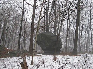
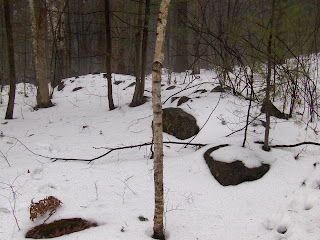
This is across Burroughs Rd from the northernmost entrance to Wolf Swap cons. land in Boxborough. You cannot miss it, but I almost did and came up from a different direction, spotting this pile for the first time, though I visited and blogged about the site previously (click here). Seeing this new pile clarifies the situation. Although the main pile I found was so smeared out no conclusions were possible, this time with the nice example above it became clear these are part of a tradition I have been calling the "Wachusett Tradition". There were the two mounds: the one above (here is another view)
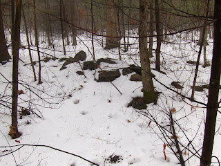
and the one I saw before:There were also several smaller rock piles nearby. I cannot tell if these are from the same time period or if perhaps they were added by people who came later and felt the place was special. For one, these small piles lay along a curve that joined the two larger mounds:
How about these outliers:These are more or less traditional, rectangular marker piles. They seem less damaged, but who knows? So, nothing too intelligent to say about this site. I was accosted by the landowner (he was not sure which 3 acres he owned, and was wondering about the missing man).

Actually I want to make one (hopefully slightly intelligent) observation: this site is about 50 yards south of Rt 111, also called "Mass Ave" in some places, and a very old trail indeed. This supports my sense that these large mound sites are near old trails, suggesting there is a basis for thinking sites are not so often out in the middle of nowhere - if one includes the old trails as well as the modern roads.

Chumash Rock Pile

"The Sacredness of the land lies in the minds of its people.
 This land is dedicated to the Spirit and memory
 of the ancestors and their children."


Tuesday, January 11, 2011

Libbey Property - Westboro MA

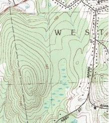
This looked like a good prospect for exploration, except that Northborough (or Northboro) is in the category of "usually disappoints". This was no exception: the part of the hill I explored had very little to see in the way of rock piles. There was one remnant pile, with a nice prospect to the west:And there actually was a bit of a site in a saddle north of the main summit. The path goes right through these, almost invisible, piles (there are 3 or 4 in the picture):
I guess I should not call this a disappointment. In any case I did not explore down around the wetlands or on all parts of the hill - so it might be worth a second look.

Back to the Triple

Rob Buchanan writes:
To escape a case of creeping cabin fever and the excesses of the holiday season I decided to head out into the cold rain on Sunday morning.

I planned to take some winter images of a couple of the more spectacular stone structures in the Wiccopee area on Putnam County NY.

I had been to the area many times and had shown Norman Muller some of the sites.

Norman recorded his observations here: http://rock-piles.com/fahnestock/index.html

The central feature is a huge boulder that has been split in two directions. The main split is in an E - W direction. There is a smaller secondary split in a N- S direction. At the E end of the E-W split there is a rectangular platform which is 3 - 4' high at its highest.

Looking generally N. Showing platform.

Looking generally W. Showing platform at the E end of the E-W split.

The platform forms the E end of stones that fill the entire E - W split. This remarkable stone fill is more evident when looking into the W end of the split.

There are many other features near The Triple. Some are described in Norman's web article. Here are some more.

A U-Shaped structure on the flat hill top to the E of The Triple.

A split boulder about 20yds E of the Triple. The boulder also has two splits (E-W & N-S) and both are filled.

A split filled boulder about 10 yds SE of The Triple.

On my way back I came across another interesting looking boulder but didn't have the time to do more than take a quick picture.

A small marker pile site

Here is the site I was examining when I located the missing person - so I might as well name the site after this significant event. So let's call this the Bykhovsky site at the western edge of Old Harvard Rd between Burroughs and Pierce.

I had been here before but wanted to remind myself of the layout. Here it is approximately:
I drew the layout in the snow to remember it:Here is one representative pile:You can see the road behind.

RIP Mr. Bykhovsy. The place was already sad when he died here. It makes me think how much rock pile sites, in general, involve the passage of time and death.

Monday, January 10, 2011

Standing Stones in PA

Norman Muller writes:
I found the following reference while searching
Google Books the other day: Henry Mercer, “An Exploration of Durham Cave, Bucks County, Pennsylvania, in 1893.” On page 155: “while at a point some distance up the river and close to the present Morgantown Road, Mr. Laubach remembers having seen from twelve to fifteen standing stones, the survivors of a group of about twenty-five formerly observed by Mr. Waters, all of which save one about 3 feet high, now remaining as a boundary mark by the Morgantown roadside and seen by him in 1893…

“The monoliths must have been carried to the spot by Indians since the rock in situ is limestone, and the Potsdam sandstone of which they consisted does not occur within two miles of the place.” (Publications of the University of Pennsylvania series in Philology Literature and Archaeology, Vol. VI, Researches upon the Antiquity of Man in the Delaware Valley and the Eastern United States, by Henry Mercer). Laubach saw the standing stones in 1855, and Waters saw them in 1853-55.

Sunday, January 09, 2011

Finding missing persons in the woods

I read reports of missing people in the woods with some interest because these are my woods. One time a person went missing in Leominster State Forest and I read that it was in a part of the woods I knew well. I thought: "...yeah it would be easy to get lost in there...I bet he is down in there near...". Another time I read about a body found by a jogger along a trail in Callahan State Forest and it was a trail I had just been on a few weeks earlier. And in these cases I think: I could find a body, why wasn't it me that found the body? After all I get out into some obscure corners of the woods that are rarely seen by anyone. I have joked about finding bodies in the woods. This morning I read (from the Lowell Sun):

"BOXBORO -- Boxboro police are asking for the public's help finding a 49-year-old man who has been missing since Friday afternoon.

Police have been searching for Konstantin Bykhovsky since Friday about 4:30 p.m., when he was last seen in the area of Burroughs Road at Chester Road.

Bykhovsky left his wallet and cell phone at home, and police say he suffers from a medical condition that may have left him in an altered mental state.

"He may appear confused or frightened," Sgt. Warren O'Brien said in a prepared statement.

Bykhovsky is described as a white male, about 5'8, 140 to 150 pounds, with balding, black hair and a thin build. He was last seen wearing a blue Patagonia jacket, dark-colored sweatpants, white socks and dark sneakers. He was also wearing a blue knit cap with a red stripe.

Anyone with information on his whereabouts is asked to call Boxboro Police immediately 978-263-2628."

So perhaps it was with this in mind that I decided to go revisit a site I knew in Boxborough, near Wolf Swamp. And as I walked along I kept my eyes open for a blue jacket. At one point a homeowner spotted me in the woods and came out to ask what I was doing - wondering if it was related to the missing man. I explained I was taking pictures of rock piles and showed him the ceremonial site that is on or next to his property. Some more of my exploration plan took me near houses and I decided to skip it with so many people keeping an eye on the woods.

So I drove down the road and stopped at a different entrance to Wolf Swamp on Old Harvard Rd. and walked back up the road a bit. I wanted to revisit another small site there before cutting down into the woods. A woman jogged by, as I am only a few feet from the road and asked: "Is the search still going on?". I said I was not searching for the missing man but taking pictures of rock piles. So that whole part of Boxborough is in an uproar about the missing person.

So I finish looking at the rock piles, reminding myself about the site layout, and then started cutting through the woods. And there is a blue jacket, scarf, gloves, and a hat in a tidy little pile on the snow. Was it a Patagonia jacket? Unsure if I should, I moved the scarf and hat to see that...sure enough...there is a Patagonia label. So I go back to the road (it is only about 50 feet) thinking I should probably call the police. The woman jogger is now coming back in the other direction and I say to her: "well you know...I actually just found a clue". She says I should call the Boxborough police; which I did, giving them my name and cellphone number. They dispatch someone.

A few minutes later a policeman arrives and I point out the blue jacket - which can be seen from the road. We chat and I say: "this locates him over here". Apparently they had been searching in another part of Boxborough. The policeman agrees and heads into the woods to look around more as I head back to my car. I turn around, drive back past the spot and now the policeman is back on the road. He motions to me, I roll down the window and he tells me the missing man is there and is "deceased" and asks me to pull over so they can ask me a few other questions. Another policemen - the "chief" arrives and I tell them I have been out walking and taking pictures for a couple of hours and explain how I came back up the road, took some pictures of rocks pile (did they want me to show them the piles? no...ok) and was just cutting through when I found the coat.

I guess they accepted my explanation because when I asked if it was morbid to want to see the body they discouraged me saying that this would now be treated as a crime scene. I made sure they had my contact information and they thanked me and I drove off.

One of the things you are kind of hoping to see until it actually happens. I am glad I did not spot the body, but at the same time I am kicking myself for missing it since it was no more than 20 feet from where I found the pile of clothes. A sad sort of merit badge: find body in woods....check.

Footprints: As soon as I stepped into the woods this morning I saw tracks. I was surprised there were any in the first patch of woods and then remembered the missing person and thought they could have been theirs. But, continuing, everywhere I went in the woods there were pretty fresh footprints in the snow and I realized belatedly that these must have been from the searchers. The searchers had been everywhere that I went. So how come they missed that one spot only ~50 feet from Old Harvard Rd?

You can make out the rock piles (they are smeared) in the foreground at the end of this video from FOX News:

Update (from WickedLocal the next day):

"Searchers used pattern and grid searches, focusing on areas where Bykhovsky often walked.

Sunday morning, a passerby spotted Bykhovsky's blue jacket off of Old Harvard Road. The jacket had been removed, and searchers soon found Bykhovsky's body with no shoes. Ryder explained that people suffering from hypothermia often feel sudden hot flashes and remove their clothes."

You can make out the rock piles (they are smeared) in the foreground at the end of this video from FOX News: [click here]

Certain peculiar earthworks near Andover, Massachusetts, Volumes 4-6 By Warren King Moorehead

by theseventhgeneration
"Certain peculiar earthworks near Andover, Massachusetts, Volumes 4-6", by Warren King Moorehead, is a 1908 bulletin. In addition to Bulletin V, this writing contains, in Bulletin IV, Part II on Fort Ancient in Ohio.

First, page 76 documents stones from Fort Ancient having been hauled away by farmers:
Second, page 152 contains the author's opinion on the effort it took to include stone in the construction of Fort Ancient.
Third, page 215 documents the early method of property boundary marking as blazing trees first, then erecting a stone wall.

Thursday, January 06, 2011

More Nevada Archeology

There is little to blog about here so I might tell you a little about Nevada.

Southern Nevada was a lake during the last ice age and today the old lake bottom is buried around the edges of the valleys by hundreds of feet of alluvial out-wash from the mountains. You can see that the desert floor rises gradually from the lowest flat point in the middle to where the out-wash emanates from the mountains. There is no terracing to indicate lake depth variations over time.If you wanted you study archeology of the lake shore you would have to dig deep into the alluvial soil. I guess that is what they are doing at Calico in CA. But that archeology would be truly ancient.

Instead I found a very minor artifact on the surface near the edges:This is made of quartz, about 5 inches long, has placement for hafting which is easier to see on the back at the top:
You can see that, although crude, there is shaping of the item and a semblance of alternating flaking around the edges:If I saw this in Concord, I would think it was a hafted digging tool and there is no reason to think it is particularly old, except by comparison with that butterscotch-colored retouched flake. That was "new"; this is probably a bit older but still a lot more recent than the glacier.

Nevada....not without its own beauty:

Stone walls passing over outcrops

Sometimes you wonder about why a stone wall does what it does when it passes over an outcrop. Sometimes the wall is interrupted by the outcrop, sometimes it seems to compulsively climb the outcrop and continue over and back down the side of it. And sometimes rather than wall there are a few isolated rock piles. I wonder if there might have been a law requiring a wall to be continuous in order to achieve proper status as a property boundary - so a compulsive climbing and crossing of the outcrop would re-enforce the legal status of the wall in its claiming of an enclosed piece of land. Sometimes the wall becomes a sequence of rock piles which, if not for the wall on either side of the outcrop, would seem to be a bit ceremonial.

For example (south side of Rocky Hill Rd) here are three such rock piles in a row:
In the fog, they have a 'feel' to them but maybe they are simply one form of compulsive outcrop crossing. That last one is a nice little pile, and certainly not built in the easiest way, if its only purpose was a legal requirement:

Wednesday, January 05, 2011

Crescent shaped rock piles - Rocky Hill Rd Groton, MA

I went back to explore around the fringes of the site I found a few weeks ago [click here]. I wanted to explore more across the street (where I saw that stone niche) but before that, I noticed a couple of extra ridges extending into the low wetlands on the same side of the road and adjacent to the original site so I decided to explore there first.

Recall that the unusual feature at the earlier site was "mound with hollow" that was triangular and, so, a bit different from all the other examples of mounds with hollows that I have been looking at. The hollow was not all that clear - as much something I wanted to see as it was real. So I am poking down towards the lowland's edge and see a rock pile that, upon inspection, seemed to be crescent shaped:And:And:This is unfamiliar - a crescent shaped rock pile - perhaps 3 feet high, 20 feet long.

To my surprise, I found another, slightly smaller, a few yards away:
And:Near these, as I poked around within an area no more than 50 feet across, I saw a couple of other piles. Perhaps more could be seen without the snow:Another:Let's remember that a triangular "mound with hollow" is pretty unusual (actually, unique in my experience). With these other unfamiliar geometric shapes (crescents) occurring no more than -say- 70 yards from the first site, I wonder if this is not something new. Certainly it seems a bit "Wachusetts Tradition"-ey but still quite unique. Searching this blog for the word "crescent" (click here and scroll down) brings up a large crescent shaped pile Norman reported, and a couple of very scrappy things from Boylston. So what gives? Is this new?

Something new?

Have we seen examples before of crescent shaped rock piles this size?
I'll post more later - a bit busy at my new job.

Monday, January 03, 2011

Snow Melting on a Stone Mound

A Turtle emerges,
Remnants of a stone row lead westward behind it
and join a zigzag row by a four foot long stone box turtle
under the big oak and hickory trees...
Some more views at http://wakinguponturtleisland.blogspot.com/2011/01/new-years-day-2011.html

Sunday, January 02, 2011

Retouched Flake from Nevada

Found very little while exploring around Las Vegas, Nevada. My son found this at the entrance to a canyon about 40 miles north of the city. I think the material is called chalcedony ("cal-said-nee"):
At first I thought it was just a nice flake, then I looked more carefully and noticed additional flaking and use wear along one edge:Here is the back.
At this point you start noticing the dark line across the top of the item, opposite to the used edge. Looks like residual staining from where the item was hafted: a small sharp edge inserted and glued into the lengthwise crack of a stick?

Saturday, January 01, 2011

Niche in Serpents Tail Tale - some more pix


http://wakinguponturtleisland.blogspot.com/2011/01/niche-in-serpents-tail.html

Granite Tourmaline - a localized ceremonial material

I have written about granite with tourmaline before [click here] and I was going to show some pictures from the field trip I led this fall to the Manoosnocs west of Leominster, where we saw a lot of it. But those pictures are lost in the innards of a dead computer. Here is an older picture of the material, showing black tourmaline crystals embedded in a matrix of feldspar - a mixture I classify loosely as "granite":
The last site we visited at the Manoosnocs had a great deal of this "granite tourmaline", used in many of the rock piles and always placed in a key location: at the top of a pile, at the corner of a pile, or two pieces placed symmetrically at either side of the middle of the surface of a flat-faced pile, etc. Similarly in the past, when I have found this material used, it always seemed to be the focus of the rock pile's design. As such, in this part of the world, it seems to be used in a way similar to how quartz is often used strategically in rock piles elsewhere: as a key element of the structure.

This material is reasonably common in the glacial till around this area and presumably its ceremonial use is limited to where it was available: down-glacier from a source in the original bedrock to the north of here. I find it used ceremonially in rock piles in a region about like this:
So, mainly it is found in the ~10 square miles south Fitchburg, Leominster, and into Sterling.

Let's think about this some more: How did everyone in this region end up using this same favored material in this same way? Of course there is some quartz available in the same region and also other light, feldspar-rich rocks. But in that case, how did an agreement get made that this was the correct substitute for quartz in this region?

Consider some possibilities: was it one person or a small group of people that were in communication with each other and developed a consensus to use granite tourmaline this way? It seems like too large an area (and too many different sites and piles) for one person to have been solely responsible. Another possibility is that there existed a generalized concept in a culture which automatically took advantage of this material when it was available - and the material's local use was limited exactly by the material's local availability - a local manifestation of a general concept. So if it had been available somewhere else, someone else would have used it without the need for specific consensus via communication.

It is tantalizing to imagine any one of these alternatives and imagine how the specific ceremonial consensus might have been shared. It would take several hours to walk across this region.

Update: I guess another theory is that it might have been started by a single person who was then imitated.