Wednesday, February 08, 2012

French Street - a roadside attraction and more

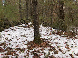
I was coming home disappointed from Drake Hill and driving east on Rt 113, just before French Street in Dunstable when glancing into the woods to the left (north) I thought I saw a rock pile in the bushes. I know this is adjacent to a conservation land; so I made the turn, parked on French Street, and walked back around the corner and into the woods. Unfortunately my camera has been acting up and auto focus was not working for some of the pictures. Here is what I saw from the road:When I went to investigate beyond this pile there was something next to an outcrop:I thought it was a rock pile coming out of a trench or break in the underlying bedrock. Actually, after a gap, the pile continues as a short stretch of wall (behind the tree) and stops a few feet later in the wetland.So I continued into the woods following the edge of the wet area. What is this?
Certainly a legitimate rock pile. Looks pretty old. And another few steps and...ta da!
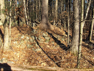
To me, this looks like a rectangular pile with a hint of a hollow, you can see one corner, suggested by this sketch.Another view of this pile:In this case, the hollow is towards the viewer and to the left. Here we are looking out and can imagine the view from this place. Today, it is in the suburbs:It was hard to get a good grasp of the overall shape of this mound because it had a tree growing out of it. Here is a last view, with stone wall behind. It is a non-trivial structure.Something a little like this:

Roadside Attractions: Rollins Rd Dunstable

Thought I'd mention:
Seen on the way back from Drake Hill.

Monday, February 06, 2012

Greetings at the brow of a hill

I climbed a hill, Drake Hill in Dunstable, and was met at the brow by an encouraging sight:
Unfortunately, that was about all I saw there. I guess, also this:

Sunday, February 05, 2012

FFC experiments with tuning a rocking stone

Cairns for sale

Norman Muller sent this from a colleague about a sparsely populated area of the Catskills.
17 acres on Sundown Road, Kerhonkson. Creek frontage tributary feeding into it that goes through the southeast. 5 acres of clear meadowland suitable for farming on either side of this tributary. Woodlands, wetlands, and ancient cairns. Can be divided to site two homes.
Please contact Judith Karpova at: dahlia@wildblue.net or call (845) 626-7355.

Sapelo Shell Rings

Reader dc sends this link about shell mounds in Florida.

Friday, February 03, 2012

Tidy quarrying

I believe keeping rocks piled up tidily makes sense where there is a not a lot of room on the hillside to get to the rock. That seemed true here, higher up the hill in Townsend State Forest. I think the large piles of rock in the woods there are just signs of careful work.

More about forest rd #3 - Townsend State Forest

With reference to the site I already mentioned here and here: Let's carry on. I crossed a first knoll with the stone wall, then saw the indistinct rock piles, then I think I crossed another knoll and went up over and down the shoulder of a ridge and into grid of rock piles. Some were smeared out, others in decent shape.For some reason I did not take a picture of one striking feature: the stone wall enclosing the site on the lower edge included a prominent large rock. For 20 feet or so on either side of this rock, the wall was double thickness, beyond which the wall resumed being a single course of rocks wide.

Then I walked across a brook:And found something I was hoping to see:I think that is a larger mound isn't it? Though it is hard to tell the ground from the mound. For another example:Closeup:The walls in this place were impressive.In this picture, note how the wall turns a corner at the end and dips to the left:A different angle shows the wall just dies off. It continues as a couple of loose rock piles, not shown, and then disappears completely at the edge of the wet.In the end, it is an "L" shaped feature next to water connecting through to everything else.

A few more nice rock piles on the way out:Here was another example of a stone wall (right hand side of the picture) dying out as it comes to the water:In this case, a little vernal pond. A rock pile in the foreground gets to look over this.

Townsend State Forest - 3rd forest road

Coming in from the east on Dudley Rd, the third forest road entrance is hard to spot on the right. I parked and walked in. As soon as the road gains a little elevation above the wetlands, there is a knoll to the left and I thought the stone wall that crossed it was the kind of configuration where sometimes there is a rock pile site on the other side of the wall:So I popped across and saw that pile of the other day:
Below on the slope, another rock pile:You can see how it is situated in front of a break in the same wall. As I mention in the video from the other day, there were also some low piles hard to make out in the snow:After that I poked around and there were scattered small piles:And adjacent knolls. I see a "V" of rocks:On the next ridge/knoll over, there was an array of marker piles, some more smeared than others. Then I crossed a small brook, looking for the mounds with hollows that often accompany such things as I had been seeing. Spotted some candidate piles.

Its late, I'm going back to bed. One of the smeared piles had a white rock that was pretty:
I continued up the forest road, determined to get all the way to the high wetland on the map fragment. I did, and made the round trip back to my car, tired. Here was the brook you walk along:

There is also a site along the 2nd forest road that I blogged about in the past. From the looks of it, I should probably also expect to find things there where the hills meet the water.

Thursday, February 02, 2012

Short Stretches of Stone Wall at Rock Pile Sites

I think we, as a community, better figure this out soon, before somebody else does. Here are some possibilities:
1. Part of an alignment - i.e. related to a direction in the sky or to another place of interest
2. To cast shadows of a particular kind
3. To create pathways that need to be followed during a ceremony.
Any other possibilities?

Utah Circular Enclosure with Entrance Gap

Wednesday, February 01, 2012

Klamath and Modoc sacred sites: rock cairns and prayer seats

Haynal, Patrick M. (2000). The Influence of Sacred Rock Cairns and Prayer Seats on Modern Klamath and Modoc Religion and World View. Journal of California and Great Basin Anthropology, 22(2).
The PDF can be found here: http://escholarship.org/uc/item/99h4b4q7#

More stone structures from n.e. Kentucky Farm

Reader Jason W. writes (continuing the discussion from here):
If u can see, in the far distance this is me, showing how long the rock wall is, look closely.
Also ,more pics.
i also found several caves ,with multiple chambers about a mile away from this site, will get pics of that too. also in the caves they all have very black ceilings and orangeish tinge, which leads me to believe they were once occupied, have also found loads of flint, tips, tools, and arrowheads, drills, etc. in the plowed field below this site.

Site H next to Dakins Brook

See map here
Let's take a closer look at the piles from lower down the hill, below Farmer's Cliffs. I think these are Wachusett Tradition piles of about the same age and with the same basic design as the piles near Horse Hill. Here is the first one, I showed the other day. Note the two larger rocks to the right.
Here is the next pile along:Note the rock, next to the pile. There is a context for this, a rock pile with a (very vestigial) tail. Another, and now it kind of makes sense:At the edge of this group let's look at some outliers. Here is a rock pile on the ground followed by one up on a support. Not too clear in the picture is that the near pile has a small upright stone. It was black.The farther rock pile also has an upright stone, which is white:
It almost looks like an effigy. The "line" from the first pile to the second one radiates outward from the site of the piles with "tails". In the previous post (here) about this site, I mentioned that nearby there were also a couple of rectangular piles, a different style.

Townsend State Forest


I forgot to mention that the rock pile, which you see slightly right of center, is next to a break in the stone wall. You can see the break at the beginning of the video clip. And, yes, there was more stuff.

Oldest of the Apple Trees

Jan. 31, 2012
Above: serpentine stone row, looking east toward the Oldest of the Apple Trees
at the site of "The Wigwams" of 1659-17??

Curtis woodcut illustration in
Cothren's History of Ancient Woodbury CT 1854
More: http://wakinguponturtleisland.blogspot.com/2012/02/oldest-of-apple-trees.html