Tuesday, April 09, 2013

YUROK GEOGRAPHY BY T. T. WATERMAN

Fig. 1—Boulder at the river's edge. This boulder was once a wo'ge or immortal, who tried to prevent death from coming into the world. Having failed, he took up his abode here, but still has an aversion to corpses. When a dead body is being taken up or down the river it has to be landed and carried behind this rock. Women also land from canoes and walk around on shore.
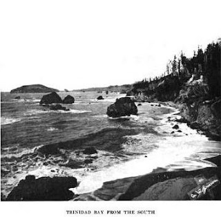
Below: A general view of Trinidad bay. At the left in the background the rounded promontory is Trinidad head. It is connected with the mainland by a low flat neck. Just to the right of the neck, on a slope or declivity below the white town of Trinidad, which is on the flat, lies the Indian town of tsu'rai. (See map 34.) Practically every rock in this picture has its own proper name.
(I was actually looking for info on "Trails" in this book: "Trails, for example, are '' like people,'' that is, they are sentient, and must be treated with urbanity. If you step out of a trail and in again, and fail to preserve decorum, the trail becomes resentful. Along each important trail there are "resting-places." Few of these show on my maps, because I did not travel the trails myself, but hundreds of such places are to be found. People when traveling kept on in a business-like way until they came to these resting-places. There they took off their packs and had a good breathing spell. If they did differently they were likely to have bad lucky The resting-places are invariably very pleasant spots. In this custom the Indians show the knowledge of experts. Five minutes' rest with the pack off in the shade is, of course, worth more in preventing fatigue than an hour of loitering along a trail..." [Waterman pg. 185])
Image above of the same place near Trinidad CA and "a story about a bunch of rocks" here: http://www.northcoastjournal.com/101305/cover1013.html

College Rock - Hopkinton/Holliston (part 1 - Ceremonial Pathway)

College Rock is the northern extremity of a large conservation area called "Rocky Woods" that spans the Holliston / Hopkinton border next to Rt85. Bruce MacAleer showed me this area a few years ago and I have been back a couple times. 
If you ever visit Massachusetts and want to see rock piles - this is the place to go - the sheer quantity of features is overwhelming and fills several square miles.It is not just rock piles but also propped boulders, split wedged rocks, delicate use of quartz (not in the the northern area but further south) and little keyhole structures made of boulders, little curved lines of rocks on the ground - stone walls that go every which way. Bruce speculated that this place was significant because of the adjacent headwaters of the Charles River. Certainly the number of structures indicates many many years of accumulated use.
My other exploration plan for Sunday did not work out, so I went instead to College Rock and went off in side directions rather than following the main trail. I remember heading south on the main trail leads to some "gap" piles. I also remember looking at a small chamber-like arrangement of outcrop. So I wanted to see something new and also I was particularly curious if I would see any mounds with hollows - the "big game" of my hunting world. 
So first I went east over to Beaver Brook. I did not see mounds with hollows.
 
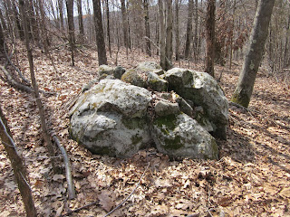
As I look at these pictures, especially the first one, I see a beaten down pathway coming up hill and passing between the rock piles. I see this sort of thing occasionally (for example at Gates Pond in Berlin) and come to the conclusion that "ceremonial pathway" may be one of the rock pile site types. It puts some perspective on these wonderful piles:
On the right hand side of the second photo, there does seem to be a larger structure - broken down. I poked around along the west side of the brook (quite close to the road at the northern end of things) and did find a rock pile with two hollows - built into the stone wall:
There are so many different things in these woods, it is hard to define individual "sites". It is not clear if this mound with hollow was built into the stone wall, built before the wall, or whether it was connected to the other structures nearby. So this was not quite the mound experience I was looking for. I headed back towards the main trail. Things big and small along the way:
 Look at the curve of low rocks on the ground:
Heading further west (on the yellow trail) Here is another interesting structure:
I am pretty sure this is a deliberate aperture, with the other rocks arranged to tune the light.
Surely light does go through that hole and would cast a shadow on the slope behind. 

Soon my mind began to numb - this place makes Dover look like a cub scout project. I started skipping things, still hoping to see larger rectangular mounds. Well I did find them, when I got further south and west (perhaps about where the "T" is in the word "HOLLISTON" on the map). More later.

Monday, April 08, 2013

Dogs

"At least 13 Native American cremation sites have been identified here, some by forensic dog teams hired by the Indians themselves. Over 10,000 artifacts have been found. Nearby a spokewheel, or medicine wheel geoglyph is on the National Register of Historic Places. The federal government is required to engage in meaningful discussions with tribal members before any major projects can be built on sacred lands. But a lawsuit filed by the Quechan tribe and statements made previously by other tribal representatives makes clear that the Indians believe the government has made a mockery of that process..." http://eastcountymagazine.org/node/10162
“Non-native people put their history in books. Our ancestors put their history on the ground and in the rocks, in the geoglyphs and in the petroglyphs, in the places where we live,”  Pico said. “Destruction  of this record is irreparable and it takes part of our lives.”  View a video of his full speech:   http://vimeo.com/38796301
 ~ http://eastcountymagazine.org/node/9104

Sunday, April 07, 2013

Yippy Ki Yi Yay

A place Bruce MacAleer showed me, I explored off to the side.

Update: Hoffman Lecture on Site Distribution - April 20th at the Robbins Museum

Curtis Hoffman writes:
Here are 2 items for the stonepiles blog.  The first is the meeting notice for the MAS semi-annual meeting on April 20th, at which I will be giving the first public presentation of my research on the distribution of stone constructions in the eastern seaboard.  The second is a new map showing the distribution, county by county, as a factor of the number of sites per square kilometer (this allows the size of the county to be factored out).  It shows the separation between the southeastern and northeastern portions of the distribution pretty clearly!

Saturday, April 06, 2013

Powisset mound without snow

I went back here to look for other sites. Found none and was brought by my feet back to the mounds of last weekend. Here was the nicest one:
I wanted to check for rectangularity and corners, and I wanted to confirm the presence of a collapsed center:
This was the "re-appetizer" of the other day. The outline was somewhere between oval and triangular.
I thought I saw one other bit of mound, in a swamp south of Strawberry Hill:
Pretty minimal. Otherwise the woods seem a bit empty down there in Dover.

Prof. Hoffman speaking Mass. Arch. Soc. Meeting on his stone structures project

From James Gage:
 
Massachusetts Archaeological Society Annual Meeting

April 20, 2013

“Stone Constructions of the Atlantic Seaboard of the US and Canada: A Preliminary Overview”
Dr. Curtiss Hoffman and Cory Fournier, Bridgewater State University

http://www.massarchaeology.org/EventsB/MAS%20Spring%20Program%20Schedule%202013.pdf

Friday, April 05, 2013

hv farmscape

Some mention of rock piles
http://hvfarmscape.wordpress.com/2011/03/28/227/

Powissett re-appetizer

Went back to here, to see it without snow. More details later:
As lovely a mound as you are likely to see -and there don't seem to be too many down in Dover.

walking in Estabrook Woods with Jonathan Brown

Near what I call the "Yellow Birch Swamp" site in Estabrook, there is swamp (duh!), with one isolated pile I know about. It is rectangular and thoroughly smeared. The initial site is thirty yards away and visible from here.
An isolated rock pile is a disappointment because it has little context. So imagine my pleasure, while out walking with Jonathan Brown, to spot a second one a few paces away. I only noticed it because we headed off in a direction that had me step on it a moment after passing the first pile. Here is the second one, you can imagine why it would be hard to spot:
 
It had a sort of rhomboidal outline. So now there is a little context for the original pile.
Another thirty yards away:
We headed up Hubbards Hill to see a stone circle:
(it is at Jonathan's feet), which I think was probably a fire circle. 

Then we headed downhill to revisit the chamber on the ~northern side. I never noticed this little altar next to the structure before:

Thus endeth a noble wall

Hiked around the north side of Horse Hill Groton/Dunstable. Did not see much but many of the walls stop well short of connecting to the nearby walls. Kind of an local phenomenon. Here was one:
 And some minor stonework, nearby:


One winged crow effigy and large rock pile

Reader Jonathan Brown writes:
... I was out on another bike ride yesterday, pedaling along with thoughts of turtles and crows running around in my head.
 
Deep in the woods I saw a glint of sunlight reflecting off what seemed to be a pond to my left and down a slope through some trees.  It's not too surprising I didn't notice it before - I had only visited this particular area a few times in winter, when everything would have blended into the white carpet of snow.
 
I decided to make the short walk down to the shore and satisfy my curiosity.  Halfway to the water I could see I was approaching a larger rock with another placed on top.  When I got up closer I almost staggered backwards realizing this was a perfect crow effigy as you had described to me only two days before!  It was almost too perfect - as if someone was playing an April Fools joke.   There was the tan head and sharp beak balanced on the brow of the base pointing to the water, and on the right side a beautiful 16" flat, dark "wing" cantilevered out in space with the help of a smaller stone beneath.  The left wing was missing, but could easily have fallen off and be in amongst the leaf litter.
Several feet in front of the "crow" was a smaller rock (2 x 3 feet) with a small goose egg sized rock placed on center atop the bigger base.
 
I then realized these were pointing at a large dark mass of stone right near the water.  On approach a thought of another "chamber" formed, and the base of this pile does show some characteristics of the B.B. Hill site - flat sides near the ground, and some defined corners.  It doesn't look like a totally random field clearing pile.  The whole structure might be ten feet square or rectangular in general shape, 5 feet high, and has hundreds of smaller uniform 4-6" rocks on top or filling the center.  I did not detect an opening, but like the hillside chamber there is a wall running past, so that has to be factored into the equation.  I guess it could be random field outcasts thrown atop a more defined base?
...I hiked all the way back to my bike to retrieve my phone so I could get a couple rough images.

Thursday, April 04, 2013

Arrowhead season...

...just started up here with the last of the snow melting from fields in Concord. So I really had my hopes up when I saw this:
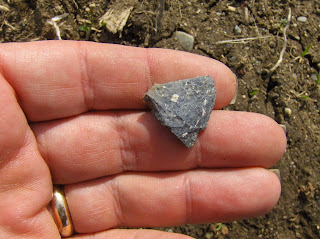
It could have been a sweet gray rhyolite triangle but it wasn't:

Potuck Creek - Greene County NY

Reader Jame Lord writes :
I believe this is one of several sites investigated long ago. I found a reference on line that quotes "along both sides of Potuck Creek"...I would like to learn more.


 [Please comment]

Added by PWAX: I looked online for the reference and see there is a possibility the structures have a mixed history:

Tuesday, April 02, 2013

Fool's Day Walk, Sometimes Hat-less

Above: Coyote Kill Site?
Below: Split Filled Boulder


That serpentine shape above could be the similar shape that shows in the 1934 aerial below:
Another larger split filled boulder:
"Dramatic" Cobbles on a fin of outcrop:
A second deer skull, as found: