Friday, December 13, 2013

Caretaking at Nonnewaug

      There’s a group of mounds here at Happiness Farm where my wife and I have lived for 30 something years, my wife’s childhood home that her mom bought back in the early 1960’s. The house dates back to sometime around 1700, possibly first “owned” by John Minor, a man who spoke several Native languages and signed many Land Deeds according to many local histories. 
      More likely, I conjecture, there was more symbolism than ownership to the act of the house being built, recalling that there’s much debate about whether those early “deeds” were actually transfers of ownership or treaties that Indigenous People made that were agreements to share the use of certain tracts of land. I’m making an educated guess that the Pomperauge Plantation elected to plop the house here on the other side of the river from what were known as the Nonnewaug Wigwams, just as was done in New Milford by that Plantation, waiting for the Native People to move from their homes around their fields and fishing place and “improve the land” by putting up rail fences (sometimes over existing native built stone fuel breaks) and claiming ownership.
Eric Sloane Illustration accessed from: http://www.wooden-box-maker.com/women-in-woodworking.html
(Some of the planks that cover the timber frame of the house show that the house was built over a long period of time. There are pit saw marks on some of them, predating the Minor/Atwood Mill about an eighth of a mile away. The wall is made of a single log – rather than a squared timber as above - with the cambian edge (and chestnut bark) still existing, one board "bole end down," the next fitted with the wider “base of the tree” end upwards.)
      I’ve been “caretaking” those mounds for going on 20 years, ever since the day I was looking for deadfall kindling and looked down at the Turtle Petroform behind my old chicken coop, eventually overtime realizing that I wasn’t looking at “field clearing stones with junk piled on them,” but rather some mounds alongside what remains of a stone row (not wall). My sketchbook entry and some really bad scans of some 35mm photos appear here: http://wakinguponturtleisland.blogspot.com/2006/07/great-moments-scan-from-sketchpad.html.
      And it’s absolutely true that chickens started the “excavation.”
     These mounds may be on my property but I don’t consider them “mine.” They belong to the Paugessett and Schaghticoke People, and in fact to all the Indigenous People who by blood or circumstance are related. They are part of History - and that history is lots longer ago than 1659. They may be graves, they may be prayers, they may be something else, or they may be “all of the above.” I may blow away leaves on occasion, pull out day lilies and poison ivy, cut down sprouting trees and pick up dead fall, but I’m never going to take anything apart. I may brush away the humus, neatly pile modern trash in a pile, but I’m not going to dig for artifacts to attempt to date the thing since the actual artifact is the pile of stones.
        Besides, I’ve seen enough scary movies to know what happens to people who mess with things like this.
      Instead, I’m going to look long and think long at what emerges as I take care of the stones. And I’ll wonder about every stone construction made after 1700 on the property – is this stone and that stone from the mounds or the stone row that used to be beside them? After all these years I’ll tell you this: some of the same sort of artwork occurs both in the mounds and the “stone walls” – that aren’t really “stone walls.”
     A quick look at something is one thing. Returning one time to look again is another.
To be able to walk a short distance and quietly contemplate 100 times or more is really something else.
Well, consider this:
(Update - I realized I left this out of the original post:)
It only took a couple years for me to realize that this just might be: A baby turtle and the remains of the egg! There are a bunch of these kind of turtles here: http://wakinguponturtleisland.blogspot.com/2012/04/x-head-single-stone-turtles.html
If I weren't care-taking (or is it care-giving?) I'd never have noticed this similar stone buried beneath the leaves and humus, sitting nicely on a flat stone platform:
Well, maybe I'd have recognized this as testudinate:
    And I’d love to have a conversation with Doug Harris. By all means, if you know him, call him up and tell him I’d like to talk to him about what I’ve been looking at and thinking about for the last 20 years or so.
Or at least ask him to look at this and these Almost Chronological Chickenyard posts:

Thursday, December 12, 2013

Caretaking - by Sydney Blackwell

The conversation on moving stones brings up a related topic. Peter Waksman ended his October talk in Harvard with the comment that the best way to respect stone structures is to take care of them.  I have wondered what that can mean.

Undisturbed structures in the woods have a beauty and integrity to them, even though they likely were not covered with leaves and accumulated humus when they were part of the regular life of the people who built them.  As more leaves and branches pile up or trees fall over on them, they become even more hidden.

Caretaking might include conservation or historical restrictions and documenting, but how much physical care?  I am thinking specifically of a small site near a quiet little brook with one to three boulder/rock mounds, several marker piles, a big split rock, and a cover stone on the brook. On the one hand, undergrowth, including berries and briars, has hidden and protected the site. On the other hand, a tree has fallen over the split rock, the mounds are becoming buried in leaf compost, a heavy rain redirected the tiny brook and undercut the cover rock support. Elsewhere, a bird-like formation is barely visible as the forest compost builds and swallows it up.

What is caretaking in this context? How much clearing, without moving stones, is appropriate? Who decides?

Wednesday, December 11, 2013

In response to the "I don't know"

But then I also believe there is an astronomical side of things that is intended to be out in the open, plain to see.
But the meaning hovers at the edge of consciousness. In the same way the shadows almost line up to pass between these rocks.

Valley Gives Day is Tomorrow

Valley Gives Day, 12.12.13,  begins tonight at midnight and will go until 11:59 PM tomorrow night. Please support us with a donation at http://www.razoo.com/story/The-Nolumbeka-Project. Thank you!

I don't know

We've been talking in comments about these hollow piles and the ethics of disturbing them. Here, I found a couple of new structures mouldering away in the woods and I am wondering: isn't it best to just leave them alone entirely? It does eventually become sad walking around these graves.
From below:
Note the slightly lower centers of these smaller piles nearby:

I think the hollow pile is ubiquitous. 
Later in the same walk (you have to look carefully):

There is a small piece of quartz.
These are from the same area of Dunklee Pond as before. Maybe I should go back in summer when it is not so gloomy.

Tuesday, December 10, 2013

Miniature Chambers / Hollow Cairns

From Mary Gage via James Gage:

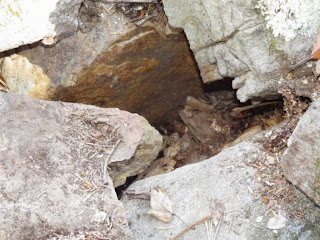
Steve Dimarzo, Pete Dimarzo and Todd Carden have been meticulously examining stone structures. They take the time to photograph every structure from all four sides and top down plus close ups of features. They are constantly looking for features. It has paid off. During this year’s field trips they came across two niches with closing stones.  Closing stones are small flat, thin stones fitted to an opening. One was found at a low niche (fig.1) surrounded by piled up stones resembling a horseshoe shaped cairn (Long Pond, Rockville, RI). The second closing stone (Voluntown, CT) was found at another low niche (fig.2) but this one had a surprise. The niche opened up into a hidden chamber. The structure looked like a cairn from the exterior (exterior 4’ L x 2’ H). To start one of the guys tested a short rectangular stone and found it loose. Upon pulling it out he found a niche. For some reason, perhaps because they had found an open shaft / cairn at another site, he decided to feel around inside (fig.3). To his surprise there was an open space inside. They then removed a single top stone and were able to view the chamber inside (fig.4). This chamber was low and made up of rectangular bars so it had straight walls like a shaft which it was originally taken to be. A hint that it was not a shaft was the irregular way the top was set up under the capstone. Out of curiosity I asked Steve to be on the lookout for other structures like this one but with corbelled walls. Steve remembered a site they had documented last spring (North Road Site, Hopkinton RI). I had major surgery last spring so Jim and I had not gotten to those sites yet. At this site the guys had found what looked like a cairn with a loose capstone. Upon removing the capstone they found and photographed a chamber with corbelled walls. In the photographs one small stone looked like it could be a closing stone, so I asked the guys to back and check it out. Todd went back this week and raked the leaves from around the base of the structure.  He did not find a closing stone instead, he found a large lintel stone with a low opening (approximately six inches high) under it leading into the chamber (fig.5). Congratulations to Steve, Pete and Todd. They have discovered a new structure the Miniature Chamber a.k.a. the Hollow Cairn. Mary Gage

Fig. 1 – Rockville, RI – The yellow rod points to a closing stoning blocking the opening of a low niche.
Fig. 2 - Voluntown, CT – This is an overall view of a miniature chamber with the closing stone lying in front of the opening.


Fig. 3 – Voluntown, CT – Feeling around inside to discover the hollow interior of the miniature chamber structure.
 

Fig. 4 – Voluntown, CT – Interior of the miniature chamber as seen after removing one of the roof stones.

Fig. 5 – Hopkinton, RI – Overall view showing low opening into this miniature chamber.
 

Fig. 6 – Hopkinton, RI – The hollow interior is revealed after one of the roof stones is removed.
 

Fig. 7 – Hopkinton, RI – Close-up photo of interior after removing roof stone.
Photos courtesy of Steve Dimarzo and Todd Carden (used with permission).

Monday, December 09, 2013

Preview of some rock piles of the past weekend

Overwhelmed with material from a visit to Codman Hill in Harvard. The good news is that this site is now conservation land. Located at the end of Murray Ln, this is the largest site in this area. It was first found by Bruce McAlleer.

Also back in NH:

Friday, December 06, 2013

Dunklee Pond - Hollis NH

I went a long way from home for my last day of exploring over Thanksgiving holiday. The area around Silver Lake State Park, and Dunklee Pond in particular, looked undisturbed and with a nice topographic combination of water and hill. It took most of an hour to drive up there and I parked and started in from the north- following the old dirt road. I hoped to find things around that inner valley there on the map and in some of the valleys between the hills:
Walking southward, I am thinking "this is a nice woods, I just wish there were more rock piles" and almost immediately one showed up on the top of a bank to my left. So I went up there and found a rock pile:
When I looked around carefully, there were two good sized rock piles, and some nearby outcrops that looked good to have been part of the "situation" as well.
So the main question is: are the rock piles way up here in NH different from the ones I am used to?
 (see the quartz?)
From the other side:
(a nice big pile). Here is a second one:
(see the bit of structure)
Here is view from the second back towards the first:
Here we see Parker Pond Brook in the background:
 Here we see the (from left to right) an outcrop, the second pile, the first pile:
Here is another small pile in relation to the outcrop, taken from left of the view in the above picture:
These piles are a bit different from the ones I know down south in MA. They are a bit like some to the north of Horse Hill in Groton. I left this place and continued on, walking to the east along the edges of the hill.

...soon I came to another place with a decrepit wall leading to something strange in the distance:
And here also were a couple of small piles around a large pile built against a boulder:
An interesting structure. The site itself, like the first above, consists of a few small piles near a big one built on a boulder. It is as though here (in NH) the "rectangular mound with hollow" has been replaced with another type of structure: a pile built against a boulder; but the smaller piles and site arrangement are familiar. 
Look at this little niche at the near end of the wall:
I walked back towards the north, I cut across a hill and couple of valleys and saw more rock piles in there:
As I wrote in an earlier post, there are plenty more woods where these came from. I can't wait to get back out there and explore some more.

Waramaug by Swimming Eel (Franklyn Bearce)

With Thanks to Tom Littledeer {http://tomslittledeer.blogspot.com/?m=1}

         “Waramaug (probably born about 1650) died in 1735 after fifty five years as a beloved and respected sachem and was buried on the eastern side of Lover's Leap Canyon.  A great monolith stone column marked the spot, surrounded by rocks and trinkets piled six feet high. Each stone represented an expression of care from a member of his tribe.  In the late 1880's, a family from Bridgeport bought the site and build a house on top of the grave site using many of the stones for the foundation..."
-       Swimming Eel (Franklyn Bearce)

Some related posts (and stone piles): 


Zigzag Fences and Fog


Cat Swamp Road, Woodbury CT


Wednesday, December 04, 2013

Lots of exploring to do in New Hampshire

Good news!
I found three sites within the red rectangle. Most of  the land to the west of that is conservation land or adjacent to conservation land; so this is good news if you are addicted to rock pile hunting.

Jones Hill

I felt overall disappointment with this exploration. It took two weekends to get to the top of the main hill and, in any case, most of what I found was on a minor unnamed hill to the southeast. Each of the outlines above is a separate site. The solid blue dot (lowest on the picture) was a solitary rectangular mound I saw while hacking my way across that slope:
In the other places the piles were small and decrepit. Not much stuff here. Note Jones Hill is somewhat between the Souhegan and Falulah watersheds.

Santa Claus lives in a Stone Chamber

by Robert Jackson Bennett - December 21st, 2010
Mr. Bennett addresses the myth that "Santa Claus lives in a workshop at the North Pole:"
     "This is not quite correct. Reports indicate that the Yule King does not live at the North Pole, but rather underneath a frigid mountain that forms the top of the world. It is similar to Olympus, but much starker and with much more brutal weather. And the King does not actually live there, but instead sleeps in an enormous cavern in the very heart of the peak. The nature of the cavern is a subject of some debate: some believe it is like an ornate tomb or dour cenotaph, while others claim it is filled with the statues of the King’s many servants, while others contend that it is filled with gears and machinery. Some suggest it is a bit of all of them. This can easily be believed, as the Country in the North (as it is called) is reported to be a very strange and dangerous place; some reckless adventurers who traveled there returned years later full of confusing stories, yet the strangest thing was that they did not seem to have aged a day.
Wayland’s Smithy, which is believed to be similar to Santa's chamber. 

     The Yule King’s beard, oddly enough, is closely linked to his chamber: as he sleeps for the remaining 361 days of the year, the beard continues to grow, eventually filling the entire room and providing much-needed insulation against the bitter winds that swirl throughout the Country in the North. When he wakes, his servants trim it back. The insulation is not actually necessary – the Yule King would sleep anyway – but it ensures that he will be well-rested, putting him in a good mood and making his Yuletide foray much better for everyone. For example, there have been only two known instances of the Yule King killing anyone on his Yuletide foray since his servants started allowing his beard to grow out in 1351.

     The idea of Santa’s workshop probably comes from some confusion over the nature of his sleeping chamber. A very popular record says that the snowy peak on his mountain stays frozen throughout the year until the winter solstice approaches. When the light begins to fade from the sky, the snow there does the precise opposite of what you would expect: rather than staying frozen, it is melted by the growing dark.
(Some sources indicate that it is melted by a particular blend of starlight, created only when certain constellations are arranged above the mountain, which happens only at the solstice; regardless, the effect is the same.) 
       The melted water then runs down the mountain and is funneled into many carven flutes and passageways, which eventually end in the Yule King’s sleeping chamber..."

Tuesday, December 03, 2013

More ice

But it is kinda sweet, climbing up...
...through the polypody.

Monday, December 02, 2013