Sunday, March 23, 2014

Tlingit Cairns in Southeast Alaska


Drs. Ralph Hartley (left) and William Hunt exploring one of the cairns. All photos courtesy William Hunt.

     "For many, (semi) retirement is a chance to kick back and relax. But for archeologist Bill Hunt, retirement gave him the opportunity to delve in to unexplored areas of southeast Alaska and uncover the secrets behind manmade rock piles called cairns that dot the landscape..."
"For the Tlingit, they have a story about a great flood that occurred some time in the un-dateable past in which the Raven caused the water to rise. The water came up out of the ground and the people had to scramble up the mountainsides to keep from drowning. If you ask the Tlingit what these cairns are, they’ll say they are flood markers. Others will tell you that people took refuge from brown bears and other animals in the larger ones..."
"We also have a team of archeologists–myself, Ralph, Amanda Davey and graduate student Mike Chodoronek–from the University of Nebraska and [we] are working with UNAVCO engineer Marianne Okal to map our survey area with ground-based LiDAR. This will provide a really detailed map of the area...One thing that we’ve found is that they vary in size—from small ones with seven or eight big stones to cairns with hundreds of large stones. They have a lot of open spaces – no soil fill inside them. They generally occur as widely spaced features in rows on mountainside benches facing the water. This arrangement made us reject their use as hunting features like blinds or to control the direction of animal movement..."

Friday, March 21, 2014

The Madison "Whodunnit?" Continues

    "And...we’ll zoom back to that “window” and the doctored image created by that amateur who claims there is a degree of artistic stacking and careful placement of stones in Indigenous stonework so that animal effigies important in their culture (and survival) are suggested by that placement (whether he knows exactly which animal it is or not), by adding in some eyes and nostrils and stuff," here at:
http://wakinguponturtleisland.blogspot.com/2014/03/the-madison-whodunnit-continues.html

Thursday, March 20, 2014

Cultural Trap Or “Whodunnit?”

Quite quickly, I find myself in a Cultural Trap as I try to describe that photo above...
(and below:)

    ...the (rock pile and other formations such as "stone walls" of Indigenous Origin) debate...could be represented by these two quotations: “The pre-European stage (of stone wall building)…was characterized by the absence of stone walls (Thorsen, page 96 of Exploring Stone Walls),” and "Certainly not all rock piles and formations (such as stone walls etc.) are Anglo-American in origin…Archaeologists have a good idea of the diagnostic characteristics of stone piles and stone walls related to European farming. We now need to get a handle on the distinctive traits of indigenous sacred rock sites (Lavin, page 298 of Connecticut’s Indigenous Peoples).”
More: http://wakinguponturtleisland.blogspot.com/2014/03/cultural-trap.html

Tuesday, March 18, 2014

Coming up...

I saw hundreds of rock piles on Sunday. Daunted at the prospect of blogging them properly. Here is a fore taste:

Wednesday, March 12, 2014

"Go Smokies" rock piles

I don't remember seeing this before:
http://gosmokies.knoxnews.com/profiles/blogs/happy-birthday-happy-holidays-happy-new-year

Dogwood Lane Sites

From Curt Hoffman:
In going through the information on Massachusetts sites at the NEARA Archive, I found a listing for a “Dogwood Road” site in Ashland, with no accompanying information except a site location.   Since this is my home town – but GoogleMaps lists no such street there --  I decided to have a look yesterday.  It turns out that the site is located at the end of Dogwood Lane, in Hopkinton State Park (but in Ashland).  While the snow was deep enough that I didn’t want to get closer to the site, I did take some pictures from the road.  There is a stone row, with what appear to be a couple of large piles, and on the far side there is a split boulder.  The latter was half-full of snow, so I don’t know whether it has any rocks filling it.  I plan to return there once the snow clears to check!


Tuesday, March 11, 2014

Wednesday, March 05, 2014

Another site gone

Two years ago I went back to visit this site and the landowner called the police when he saw me and FFC cutting into the woods near his property. I wondered at the time why the reaction was so swift and so negative. I chalked it up to transplanted city-folk not knowing about rural woods walking traditions. Now, my guess is this guy was digging up something he knew he should not. 

See that place with rocks, scraped clean for no obvious reason?
Maybe this one is my fault. I marked the site on a map and sent it to the Littleton Historical Commission. But I am not sure of the timing. Maybe our trespassing set off the landowner?

A pretty little site. I have some photos somewhere. To prevent further mishap: Littleton residents beware! Here are some places that may need feet-on-the-ground protection. 
The bulldozing is between Harwood and Grimes Ln. Maybe some part of the site is still there?

In terms of a longstanding argument I have with NEARA, let's hope someone can keep a step ahead of the bulldozers next time. Secrecy can be harmful when no one knows a site is about to disappear.

Not much....

2014 was the second year in a row that I did not find an arrowhead in the month of February. Too much snow on the ground.

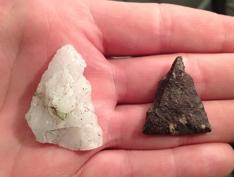
I went out on Saturday in the afternoon. The first day of March, a new month, one with more promise of being able to find something. Most of my favorite spots are still covered with snow so I went to a place right on the coast. Conditions were perfect, the ground totally bare, no footprints to distract me. Unfortunately, the icy wind coming off the water was relentless, howling. With my back to the wind it was tolerable but going the other way, facing into the wind- even bundled up as I was, it was too much. I left there and went to a different place sheltered from the gusts of cold wind. The surface of the ground was covered with broken shells from centuries of feasting, mixed with countless stone flakes from making tools. Well, here is something.
It's a triangular quartz arrowhead, missing one corner. It's crude, chunky. It's a find and I am glad to have it. Here it is cleaned up at home along with a broken fragment from the first place.
That broken fragment is a piece of something that was wonderful. It's paper thin, the workmanship is exquisite, the edges are intricately flaked, sharp and straight. The red material with white crystals is really pretty. It's such a small fragment I can't even say what this was a piece of but I suspect this was one corner of a very big triangle. It's tantalizing and things like this keep my imagination fired up when I find them in places where most of what I spot are crude tools and quartz points. I hope that there is a whole one like this for me to find somewhere, and you need to find a lot of broken ones to find whole ones... I will keep looking.

Tuesday, March 04, 2014

"West Along the River" from The Montague Reporter by David Brule

(From the Nolumbeka Project)
The piece beautifully captures the deeper spiritual dimension that inspires our work and gives it energy:   
nolumbekanews.blogspot.com

Monday, March 03, 2014

Marker Piles: A final interpretation/opinion - its about projected shadows

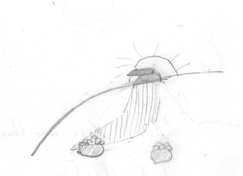
Since the beginning of this blog I have been writing about marker pile sites, drawing pictures like this:
and calling attention to places where the rock piles are in lines, and mostly evenly spaced. If there are enough piles it starts to look like a grid - hence the naming of the Acton Grid, Stow Grid, and other places. I also called attention to how often the ground is flat (not necessarily level) and how often the piles would have a clean vertical surface on one side.
Somewhere along the line, I started wondering about shadows cast by the piles and about shadows cast upon the piles by some other nearby feature. I noticed, for example, that the vertical face was usually oriented perpendicular to the line containing the pile. [Saw this at the EMC Southborough site in winter, but I can't find the link.] Also, it seems eminently reasonable to prefer hills with flat sides if you want shadows to move across them at an even speed. Also I wondered if the shadows might pass from pile to pile during the day, or perhaps as the season comes and goes. Now, I think I've found an example that illustrates the principle in a simple way.
So I went walking in Littleton at the Hartwell Family Memorial, which is on the back side of a hill I visited long ago: Proctor Hill. Went up the valley to the north, circled a bit east and then south to the southern sub-summit. Even before I got there I could tell this was the hill's best place to look out over Beaver Brook and the valley with the "Boxborough Esker". And there was a rock pile:
I could see something up hill, on the horizon:
And a few feet to the side, across the hill at the same level was another pile.
(We are looking back towards the first pile). Again, I looked up hill at the other feature there:
Now let's have a closer look at that upper feature above:
This looks suspiciously like some sort of pointer. Something that would cast precise shadows. Also, if you look at the earlier pictures, you can see this 'pointer' is on the horizon from the point of view of each of the two piles.  Here is the view back towards to two piles:
[Look how flat that ground is. Shadows from the pointer can reach anywhere on the slope.]
In these views, we are looking north east. The 'pointer' is to the southwest of the piles and, at sunset, its shadow would stretch down the slope. It is likely that the shadow from the pointer lies at the edge of one or the other rock piles, at some point during the year. 
So I think this is what must be going on: As the sun sets, the shadows elongate and sweep across some part of the hill and then vanish.
Maybe the rock piles mark seasonal or daily limits?
Given the configuration of the site, this feels like the correct explanation for the site layout. But these are perfectly measurable effects. It will take someone who can measure these alignments carefully to come out and test the hypothesis. Maybe there is a solstice involved.

There might be a few more rock piles there under the snow? Here is a view from below, back towards the site:
Summary of marker pile features:
Q: Why are the piles evenly spaced? 
A: For the same reason measurement intervals are marked out regularly on a ruler, to divide time evenly.

Q: Why are the piles in lines? 
A: So they will all be roughly the same distance from the shadow source. Sometimes the lines curve.

Q: Why do the piles have a vertical face perpendicular to the line of the piles?
A: Actually the face is more in line with, and parallel to, the shadow. Presumably for greater precision.

Q: Why does the ground need to be flat?
A: So shadows stretch all the way across a smooth surface, and move at a regular rate over the day and season.

Q: What are these "marker pile" sites for? 
A: Marking time, performing a calendrical function.

[Update] Practical Implication: when at a grid turn around 360 degrees  and look for a shadow source on the horizon. EG kettle holes and the way the rock piles spiral up from the bottom.

Sunday, March 02, 2014

The snow is still deep but there is a crust and....

...things are beginning to peek through. For example, with a big split rock one wants to go have a closer look:

Waiting on Woodbridge

    While I am sort of busy looking out for what stones emerge first from under the melting and then refreezing snow, I’m also looking at old files of photos from Woodbridge CT, most of them from late Spring of 2009. The former activity is a little hazardous as I drive and sometimes stop along narrow, frozen snow banked roads along the back roads or glimpse them from the interstate system but there’s so much I never noticed before, rows of stones running up to outcrops or possibly large boulders. The latter activity is the much safer of the two since I pose no hazard to navigation sitting in front of this screen…
    I’m also doing some “recon” on a little hill in Woodbridge where a bit of Blue Trail loops around it, where a few spots have caught my friend Peter’s eye
 – and my interest is peaked in some of the same spots, those little round bumps on little wide and relatively level places between the contours, the wet and swampy places. Since it’s all snow covered, I’ve been gawking at some aerials from different sources – and so has my friend dc. And I find we too share some spots that catch our collective eyes.
     Since I’ve been to the Preserve that shares a parking spot with this one, I don’t doubt that there’s something there, but I wonder if it could be just as jam packed with features such as I’ve see there…

The first screen capture probably won’t impress you much:
That’s a “Bird’s Eye View” from Bing maps. Change the direction of view and suddenly things jump out at you – the river obviously, but also boulders and stones in an area it’s doubtful that anyone ever plowed or cleared field stones from and some massive looking rows of stones as well:
There’s no way to get much detail from these images (poor as they are), but that is an impressive couple rows of stones. How bad is this image below?
But on the hill side to the south of this unnamed hill is what PW calls the Judges Woods, I’ve been walking about there several times and I've seen some similar looking rows where shapes and possibly artistic placement, maybe even with some rock carving/shaping activity might have happened too, makes me think, “There’s that Indian Look” - again."
   Again from Bing, here below is just one such spot that resembles it: 

   And suddenly, as I write this, I remember this: http://rockpiles.blogspot.com/2009/09/searching-for-serpent.html and feel like I should sometime return and check if there is an interesting large boulder at the end of both these segments of carefully stacked stones that look like this on the ground:
To get back to the boulders, here’s one “concentration” or “segment” that I may not have posted before from my very first visit to the Preserve, over by Peter’s childhood home:

 That first word that popped up in my Ink Blot Impression area of my brain was “Mountain Lion.” And the word “couch” came up for that boulder next to it – mostly because there’s a similar shaped stone perched on top of a huge boulder at Chimney Cave in Watertown CT, part of the Old Hunting Caves, now better known as Leatherman Caves. But these Woodbridge boulders are “linked” (and if you say that it’s some colonial livestock fence and nothing more, I will wiggle my eyebrows like Groucho Marx and quote him as I say “I can’t say that I don’t not disagree with you” about that…):

And your view of the bigger boulder, as you move toward that couch, may no longer remind you of a Puma, but possibly another sort of animal that may have been purposely enhanced by the same kind of animal perhaps:
 
Interesting edge on the back rest part of the 'couch:'