Monday, February 12, 2007

Wall bulges from Boxborough

I have probably already blogged these.

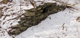
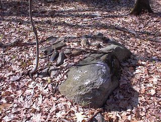
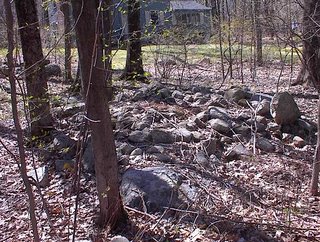
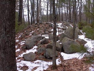
To interrup the gray colorless winter photos, here are some from last summer. These are about 1/4 mile from the place described in the previous post [Click here] . I call these "Wall Bulges". They live in that mysterious borderland between the practical and the ceremonial.
Here is another (2 views)Here is a third from in there.
Nice colors.
I was looking at the Fort Devens stone wall map (described here), and spotted a place Boxborough with irregular stone walls in a place I had missed examining previously. So I figured out how to get there and it was my first destination Saturday. I parked and walked into the woods. For a while it was all torn up with bulldozed areas, sandpits, and trash. But I walked further in and eventually got to an area with a few rock piles. Here is a small wetland - source of a brook - enclosed by stone walls:
To the left is a knoll facing west. There are a few rock piles on it. Here is one.
Note the quartz, in this detail shot:
Here are two views of another.
This is the first substantial pile I have found in several weeks. You can see these are both supported piles, at the top of the knoll and facing west over the brook as it curves around the base of the knoll.

A few yards further along were a few piles on a slope, like the remnants of a marker pile site.
This last one looks like it was vandalized very recently. There were a couple of others like it and I thought there were traces of someone having driven over them deliberately with some kind of ATV.

So this is hardly a huge site. Just a bit of relatively undisturbed woods. In Boxborough you can almost always find things in relatively undisturbed woods. As I wandered around, here was a substantial pile right behind a house:
I noticed a few other odds and ends: what looked like a "gateway" pile, a ground pile here, a false outcrop there.

Returning to the spot were I photo'd the panorama above, there was a rock pile at my feet:
And also this old friend, a nice example of a split-wedged rock:
No doubt this whole area was once filled with ceremonial structures. A few are still left in there.

The Fort Devens Stone Wall Map and Site Hunting Strategies

FFC gave me a map he found at the Carlisle landfill - a 1923 topo map of the area around Fort Devens (mayb ~10 miles on either side) that shows all the stone walls. Dan Boudillion first mentioned this map to me and Bruce McAleer had given me some xerox copies but it was nice to get the full map in its original form. It is a fascinating document. For the most part the stone walls form parallelograms or other rectalinear shapes which sub-divide the landscape. But there are other places on the map where the walls go crazy. Places with pentagonal outlines, diamonds, triangles, little short stretches of wall, bits that follow the natural contours of the hills and wetlands. It is very interesting to note that one place on the map with the most rock piles (as far as I know) is also one of the places where the walls are very irregular. As another example, I was looking over the map and spotted an area of irregularity and though...hmmm...before I realized that that was the place I found a nice site on Dec. 26. So this observation of a correlation between rock pile sites and irregular stone walls leads naturally to the strategy of searching out on the ground places where the walls seem weird on the map. I practised this strategy last weekend and found a rock pile site - but I probably would have found one anyway in that big a patch of Boxborough woods. I post about that later. Another thing of iterest on the map is where the stone walls are not. Because those are places where it is too sandy for there to be wall making material. There will not be rock piles there either in most cases. Lately I have been having to drive further away from home to go exploring in new woods and there are two things that can spoil the day: sandy soil and new housing developments. There is nothing more disapointing then driving for 3/4 hours only to end up in a spot with sand and no rocks for walls or rock piles. After that long a drive the day is shot. So now I have a way of screening those places out, t least near Fort Devens: I make sure there are stone walls in the vicininty. Finally, I think there are other pieces of interesting information hidden in the tangle of lines on this map. I see a number of east-west directed walls. But very few true north-south walls and I am not sure how many magnetic north-south ones. I wonder how many of these walls might line up with a solstice?

Note: A i resolution pdf of the map is linked to on the right.

Preview of week for Feb 2007

I had a decent weekend of exploration with the bonus of being guided to a site on Sunday - taking the guesswork out of things.

On Saturday, I found a smidgen of a rock pile site in Boxborough at a place where the Fort Devens stone-wall map indicates irregular stone walls. I'll talk more later about this as a strategy for locating sites. Anyway after that I had time to cruise to the other side of the valley, in Littleton, and take some photos of the well-known stone chambers (I think there might be 3) along Whitcomb Ave. Then I went to explore near a site I knew, just to see if there were some more piles to one side of it - there were.

On Sunday, the plan was to go to meet a guide to a site in Wayland. I was shown a huge solitary rock pile, with a bit of a retaining wall, in a style we have discussed here recently. That was pretty impressive and on the way back to the car we stopped at a place which (I should have recognized as somewhere) I had been before, for a few more pictures.

So I'll be rolling out some descriptions as time permits in the next few days. Hope it is interesting.

Sunday, February 11, 2007

Saturday, February 10, 2007

Appetizer - Stone Chambers along Whitcomb Ave in Littleton, MA

This is a chamber that has been mentioned before. I do not know if M&D knew about it, it is near a more famous other one directly along the road. As far as my experience goes about this, it was first spotted by Derek Gunn as we drove by on the way to the other chamber. More on this later.

Thursday, February 08, 2007

Somewhere on Oak Hill in Littleton, MA

Old but sturdy. The rocks look burnt.

Out the car window in the Shaker lands of Harvard, MA

It is hard to miss the rock piles along in here. Since one of my favorite narratives is the juxtaposition of ceremonial and old (if not ancient) structures with signs of modern suburban life, you'll understand why I like these pictures:

Wolf Rock - Carlisle, MA. From Tim Fohl

Tim writes:

There is an assemblage in Carlisle, MA at the Great Brook Farm State Park. It is quite well known in part but I believe the more subtle aspects are not known widely. It is called Wolf Rock supposedly because a den of wolves once lived there. Wolf associations are also code words for Indians and the area abuts Tophet Swamp, another code word. Tradition places Indian activities in Tophet Swamp. The site is located, appropriately enough, at the end of Wolf Rock Road. The structure itself consists of a sort of cave formed by three enormous rocks about fifteen feet high:
A person could easily be sheltered in the cavity. The less well known feature is a stone row with what looks like a snake head at the end. The nose of the "snake" points to the cavity as shown in the following two pictures:
The body of the "snake" goes about 300 feet and projects into a spring fed pond. The path of the of the body is shown in the aerial photograph below. Part of the body looks like a conventional wall but other parts definitely do not.As noted the "tail" projects into a pond about 10-15 feet. This section is shown in the following photo.There are a number of other interesting features in this area. I hope to survey them more thoroughly in the future.

Wednesday, February 07, 2007

British Rock Art Blog [Click here]
Interesting especially if you are interested in man-modified rocks.

For example this in a comment:
"
Hi George
Quartz hammered into fissures sounds very intriguing, will have to look that site up.
It would be interesting to know the thinking behind that. Another glimpse of thier ritual practices?
At the scandanavian sites the cracks were packed with small stones to “seal” the flints and bits of pottery etc inside. Apparently they also brought ‘ancestral flints’ to one outcrop, ie mesolithic flints that were already ancient when carvings were in use."

As I read this blog, I see the writer is pre-occupied with the same sort of questions about rock art as I am here about rock piles.

Inukshuk Videos

I promised myself I would not spend a lot of time posting about Inukshuk on this blog. They are fascinating but not, I think, too related to the rock piles we have here in New England. But I am having fun playing with Google video searches. I also got a lot of results searching for "Indian Mounds".

[Click here]

rock pile videos from Google

Tibet rock pile [Click here]

Try this one [Click here]

Tuesday, February 06, 2007

Big piles with retaining walls. Norman Muller writes in.

Norman writes:

I was looking at recent images on your blog and spotted the large pile with the retaining wall, and your comment that the graded stones in the center suggests that this pile was the result of field clearing.
There is a large broken down pile in Rochester, VT, which also has a retaining wall around it (not in great shape) and with the center consisting mostly of small stones. This is part of a huge collection of cairns spread over an area of 50+ acres. Many of these cairns seem to have small stones as fill, and so one has to be careful concluding that piles of this sort are the result of field clearing. I don't believe the one I am linking above (from this site in Rochester) has anything to do with field clearing, nor do any of the others. Note the manitou stone in front. There are two views of this pile, one taken from the road and one side view. I believe stones were scavenged from the mound to build the foundation of the farm buildings.

A field clearing pile

This is a fine example of a field clearing pile for comparison with other piles which are similar but which, I claim may be ceremonial. This one is not. Notice the following features:
  • At the edge of a drop-off
  • Tumbled down the drop-off, not built up
  • Next to an open field [not visible in photo]
  • Large boulders clustered together and separated from smaller ones, in the nearground
  • No retaining wall

A site on Stow Rd. - from Journals, Dec. 2005

Then I went back to my car and was planning to go down through XXX center to the other side of YYY Hill. But instead I saw this out the car window to my left. I had seen this once before but hadn't been able to find it again. So this time I parked the car and got out to take a look.
It struck me that this is a pretty classic vertical faced pile. But other signs of a "marker pile site" were lacking.

Behind this one I spotted something large looming under the tree branches:
Before examing it, I photo'ed a nearby rock-on-rock group and also an uneven ridge of larger rocks and boulders.This is not a stone wall but a somewhat wiggly line leading from the road (in the background of the picture) down to the large pile. I imagined this line as a tail connecting to the head of the larger pile.
Here is another view of this larger pile. It is a classic "wall bulge" but without the wall. The pile itself has a well-built retaining wall. This is essentially identical to the piles at ZZZ Pond in Carlisle. You can see the pile contains rocks of all sizes but which have been carefully graded. The basic principles of field clearing are visible.

But then there are things like this nearby:
Also one observes that the water starts at the big pile and then flows eastward a short ways into HHH Brook. Things like a stack in the water or this rather large rock-on-rock are not compatible with simple farming.

I also am struck by anomalies like this one in the wall there. The site is in a quadrant surrounded by stone walls. This is a view to the east (photo'd a couple of days later):
This seems like a reasonably good example of where the basic height of the wall is uniform and [as described in the previous post] one portion sticks noticeably above that height - a little symmetry with a window. It also looks like an example where the horizon is visible through the see-through hole.

Update: It is quite possible that farmers clearing fields might dump their cartloads onto an existing rock pile.

Monday, February 05, 2007

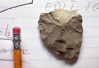
Blue mudstone tool

From Concord, MA. The official name of this material is Cambridge blue argillite. It is one of the commonest materials used, mostly, by the maritime archaic cultures of this area.

"See-through" stone wall at the high point

It seems to be a classic pattern that a stone walls becomes suddenly higher as it passes over the high point of a knoll (see here). While passing over this high point, the wall also becomes lacey: with one or several holes that you can see through. It is possible this is part of a ceremonial architecture, but it will take a lot more examples before I am convinced. Meanwhile, lets keep our eyes out for examples of this phenomenon. Here are a couple of example from Groton on the way to Horse Hill. (Even a small bit of snow makes it hard to find rock piles. But obviously it would take a lot of snow to hide these walls. That is what I could look at this weekend.) In this example, the "see-through" structure is a good three courses higher than the rest of the wall. It is hard to not see that as deliberate.

Sunday, February 04, 2007

Indian Country - the Nation's Leading American Indian News Source

http://www.indiancountry.com/

The Klamath Indians of Southern Oregon

Verne Ray noted that in both Klamath and Modoc cultures, there was considerable emphasis on "making artificial rock piles for religious or commemorative purposes and for attributing mythological significance to rock piles of unknown origin" [Click here for the whole article]

Camp Wawanaquassick

A website about rock piles. I think I know who is the "expert from Princeton" they mention. I don't know how this one escaped my attention. Maybe it is new. [Click here]