Monday, September 22, 2008

Turtle Island

Prompted by the comment below, I added the above poster that hangs in my bedroom...


From Wikipedia, the free encyclopedia:
"Turtle Island is the English language translation of many Native American tribes' terms for the continent of North America. The term is proposed as a substitute for or synonym for North America. The term was brought into popular usage by Gary Snyder through his book Turtle Island[1] in 1974. In a later essay, published in At Home on the Earth,[1] Snyder claimed this title as a term referring to North America which synthesizes both indigenous and colonizer cultures by translating the indigenous name into the colonizer's languages (the Spanish "Isla Tortuga" being proposed as a name as well). Snyder argues that understanding North America under the name of Turtle Island will help shift conceptions of the continent.
Referring to North America as Turtle Island suggests a view of North America not merely as a land "discovered" and colonized by people of European descent, but as a land inhabited and stewarded by a collection of rich, diverse, and civilized peoples. This collection may have room for both indigenous and colonizer cultures. This re-framing of the identity of North America is intended to bring about a better cohabitation of these two groups of people.

Finally the term suggests to some interpreters a more holistic relationship between people and the continent's ecology, visualizing Turtle Island as an amalgamation of bioregions."
Wednesday, September 17, 2008

Exploring a Valley in Harvard, MA (part 2)

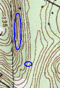
Here again is the map. Let's start looking at the larger site on the hillside:What seems to be a steep slope actually has a shoulder with springs - water coming out all along the side of the hill. There were also continuous rock piles, highlighting the blessing of the water as well as the view outwards to the east. Some of the piles were clustered in small self-contained groups; others seemed part of a larger organization. Here is the largest rock pile:
If you watch the video, you'll see a number of things in the background. Let's take a closer look at one of the rock-on-rocks. You can see the large pile in this picture's background:Even closer:That black vein must be part of the setup: ritualized use of unique rocks, large and small rock piles, unusual springs on the side of a hill. This is almost certainly a Native American ceremonial location. It is not more than fifty yards from a house.

Let's have one more look at that big pile:
Harvard never disappoints.

Tuesday, September 16, 2008

Exploring a valley in Harvard MA

I noticed a piece of woods on the topo map. I had explored it before but not thoroughly and I saw that if I headed north, rather than east from the obvious parking, then I would be in a new place. It turned out to be a small valley with a brook, a surrounding alluvial area, a steep hill on the west side and a more gradual one to the east. I planned to walk in on the east side of the brook and cross where possible, explore some of the west side of the valley, then loop back over to the east side and explore what I missed on the way in.

I saw a small damaged rock pile next to a stone wall, nothing too dramatic, and I was scanning the woods for something more substantial. I saw this on the far side of the brook. Surely a man-made tumble of rocks.
You can see there are lots of loose rocks behind this. I could not make much sense of it except that it certainly included some remnants that looked like rock piles:This is on the other side, looking back towards the brook. Here is another similar view, looking past a different pile:But I do not know. There were too many suggestions of structure to be confident what I was looking at. Maybe this was not originally rock piles? After all, rock piles are what you get in any kind of a ruin. I could not tell for this place. Here are some of the tumbled rocks suggesting an unfamiliar structure:This site is represented by the smaller blue outline on the map fragment above.

Monday, September 15, 2008

Saturday, September 13, 2008

A platform pile by a brook at that "roadside site in Sterling"

Almost not worth reporting but somehow, to me, these rectangular piles at the edge of water are a kind of "big game". I associate them with the kinds of piles I see high on the Mannoosnucs but there is no evidence of it (although they are within easy walking distance). Anyway this was not exactly rectangular but more a lopsided diamond with one corned pointing toward the wet. Here is another view - it is buried in the ferns.
And here it is from a short ways downhill. You can see there are other damaged structures in the foreground.

Fort Miami is an ancient waterworks not a fort

[Click here]
(via archaeological)

Friday, September 12, 2008

Eastern States Rock Art Conference

(Thanks for Norman Muller for this information)

In the Summer 2008 ESRARA Newsletter, there is a notice on page 16 of upcoming conferences, one of which is the Eastern States Rock Art Conference (ESRAC) March 27-29, 2009. Tommy Hudson, the organizer of the conference writes: "There is also a call for papers. Rock art, stone piles and constructions, geoglyphs, iconography, and all subjects related are welcome. As an example, I will give a presentation on serpentine stone walls in North Georgia and their relationship to the tri-level cosmos." Hudson can be reached at myrockart@yahoo.com or by phone at 678-983-5333.

Update: The conference will be held at Red Top Mountain State Park (www.redtopmountain.com) about thirty miles north of Atlanta. A block of twenty rooms has been set aside at the park. Deadline for reserving the rooms will be January 27, 2009.

Thursday, September 11, 2008

A roadside rock pile site in Sterling, MA

I was driving along Elm Street from Leominster down into Sterling and saw a rock pile a few feet from the road under the pine saplings. It turned out to be kind of an interesting pile. A loose tumble of cobbles piled on a boulder. It does not look like much at first glance:The boulder is somewhat elongated left-right in this picture and, if you look at the left end, you can make out two lines of cobbles extending out to the left. Here is a view over the boulder from that end, between the two extended lines of cobbles. You see not only the two lines of rocks extending forward. And you can also see a white rock in the middle of the upside-down "V". This is enough symmetry for me to consider this to be an effigy. No idea what it might represent.

On top of the pile:
A beer bottle pointing towards the wetland, where there were a few more piles.I walked around the area between the road and a brook/wetland for about 1/2 hour spotting a few things here and there. There were a couple of things uphill on the other side of the road, like this other boulder pile:And there was also another pile right at the edge of a little wet spot that also seemed like an effigy. I made a little video about it:


I also found a 10x10 foot platform pile which I'll report separately.

Small snapping turtle

The shell was about 6" long:

Wednesday, September 10, 2008

One site report coming

After last weekend, I have one little site to report from Sterling, MA. But with Tim doing all the heavy lifting this week, I am enjoying the vacation.

Tuesday, September 09, 2008

Yurok, Karok, and Rocks


Mavor and Dix have a bunch of Yurok references in “Manitou,” mostly taken from a 1925 book on CA Indians. I recall highlighting “rock ref.’s” on a flight to San Diego, just before driving down to see my brother-in-law’s new house in Baja California. These are the people who put the idea of stone prayer seats into our collective heads.
The Karok People are also discussed in the “Handbook,” the up-river neighbor’s of the Yurok, both of whom spoke an isolated Algonquian dialect - and an oral tradition as coming from "the east." The two groups never saw white people until about 1850. There are no references to burning over the landscape, but other sources link their dependence on acorns as food to a management of oak groves by fire, and other plant resources as well.
There’s even some photos of the Rocks that have names…


New "Friends of the Falls" Post

Monday, September 08, 2008

Observing the rising and setting of celestial bodies

Click on some of the pictures of text in Tim's post below and you can see one of them includes a discussion of the affect of dis-continuing the yearly burn offs:

"The tradition of observing ritually the rising and setting of celestial bodies on the horizon became increasingly difficuly to practice after contact...."

That seems like a pretty significant quote; especially for Mavor and Dix's readers.

Is That a Bear?

A composite photo: Peter's Sunday, September 07, 2008 post, "A small site at the start of a brook - Harvard, MA," and photos from mine from a year or so ago:
http://wakinguponturtleisland.blogspot.com/2007/06/old-friend.html .
They reminded me of each other and these were the closest to the same angles...

Waking Up (and Burning) Again Again


That "Burning Question" was on my mind again this morning when I woke up (on Turtle Island again).

Much of my own personal library is old textbooks from relatives and tag sales (Maybe yours is too), and that's very true of my Indian related stuff. So I looked at the oldest of relatives text books first, checking the index of each for "burning." Back around 1976, UCONN was using Trigger's 1969 "Huron: Farmers of the North" as a text my brother John paid $4.95 for. "Slash + Burn," he wrote in the margin. Compare that to the many entries in Cronon's "Changes in the Land," that my sister Joan was using a dozen years later at the same school, possibly the same or a similar course (I'd add the photo, but I failed to put the book back on the shelf and will soon surprise my self by finding it in a strange place - and where is "1491' where the number of entries is staggering?)

That's OK, because I know that you've seen Norman's comment and are probably planning on stopping by either the library or bookstore to get a copy.

Then I spied my copy of "Manitou" and found the entry in the index of that book.

They were onto the same idea, starting really on page 124, under the sub title "Ecology..."

Sunday, September 07, 2008

A small site at the start of a brook - Harvard, MA

You step off the road in Harvard and more or less expect to find rock piles. There was a patch of woods I never explored, along Rt 111, so I stepped into the woods there last weekend and went downhill, past signs this was an old farm or orchard, down to the edge of a wetland. My feet found the first rock pile and, looking around to see if it was isolated, I saw a couple of others. Then I noticed an interesting configuration of wall, rock-on-rock, and rock pile - all in a line.

It was something like this:
This shows a portion of a stone wall at the top of the picture, a rock-on-rock, a rock pile, and the brook/wetland flowing off to the right. I left out some small boulders that are also in the line.

Here is a first pile, found by my feet: a rough oval, including a piece of quartz or quartzite:
Here is a closeup of the quartz:
There were a few other inconspicuous piles nearby, I might easily have missed them.

The main thing that caught my eye was a rock-on-rock next to the beginning of the brook.
I got the impression that the larger boulders in the brook were in a line with this rock-on-rock and, as I looked along the line, I could make out a break in the stone wall. Something prompted me to look behind me along the same line. There, hidden in the vines was a more substantial rock pile:Of interest, was the reddish burnt looking rock in the pile.
But what was most interesting was when I went to take a closer look at the rock-on-rock and found it was made of quartz.
This is quite rare and I can only think of two other places where I have seen quartz used in a rock-on-rock. One was at the end of a line of rock piles (not more than a mile from this current spot) the other was also associated with an alignment.

Following the same line over to the stone wall, there was a break in the stone wall and another piece of quartz:The next picture (sorry for the blurring) shows the whole line, with the stone wall in the foreground, the rock-on-rock behind it, then another boulder in the brook, and the larger rock pile is behind that in the same line: