Thursday, May 31, 2007

South African Photos From Norman Muller

by JimP
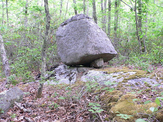
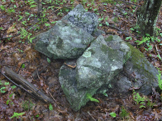
Norman writes, "I'm attaching two photos that Bo Westling, a researcher from Sweden, sent me of two perched boulders in South Africa that his son-in-law took on a recent trip there. Bo has written a book (in Swedish) about perched and pedestaled boulders in his country, and is an authority on the subject. He pointed out to me that the portion of S. Africa where the photos were taken has not been glaciated."Norman also adds, "That first image of the white perched boulder in a desert environment could be what is called a tor, which is a highly weathered outcrop that looks manipulated. Such forms are found in southern England, and are sometimes located near dolmens. One researcher believes that the dolmen form was inspired by the natural tor formation."

Wednesday, May 30, 2007

The modern mixed with the more ancient

These are from Moenave, Navajo Reservation - behind the dinsosaur footprints.

Apache signal quality

At a hotel in Winslow AZ with no internet - but turned on the computer in order to look at the pics I took today. Then up pops the little info-bubble "Wireless Network Detected". Come to double click on that and, what do you know? The nearby Apache reservation appears to have a network I can borrow; and so do the Zuni's. The Apache's signal quality is better. We had a great day: found and arrowhead, saw some dino footprints and a Navajo "Newspaper Rock" of petroglyphs. We did not see the Condors. Then we got bummed by the hostile reception of the Hopi res. I don't know why they don't just put up a sign saying - "Visitors not Welcome". One of their traffic cops followed me for 10 miles hoping to catch me speeding - right on out of their territory: he thought I did not see him back there but I saw him alright - we had just finished trying out the rental car at 100 mph before slowing down to his location. Op! gotta go, Galaxy quest is on cable. Yes we saw some rock piles; but all in good time.

New From Larry Harrop -- Arcadia Management Area (RI)

by JimP
Larry Harrop has some new galleries up from his visit with Bob Miner to the Arcadia Management Area in Rhode Island. Here are a few of the photos:

First, a nice split-wedge:A couple of the wonderful cairns:A nice propped boulder:

[CLICK HERE] to see the rest of Larry's photos from this site.

Sunday, May 27, 2007

Hi from AZ

First day here we had a great day in the Tonto Basin and could not get shut of Sedona fast enough - fun trying to come up with the right turn of phrase for that place. Something like: a strip mall set against the most beautiful background imaginable. Tomorrow - Grand Canyon. I did see one rock pile but it was suspicious. I'll write about it later.

Jim P: we were in a hurry to get out of Phoenix but we'll be back next weekend, hope to make some plan then.

Ringing Rocks yet again

By GeophileBack to Ringing Rocks today, and we saw a whole new part of the park. With my son Jonas looking, too, we found a few more features on the way. The above was part of a wall/row that we found off the trail. We saw another, but the pictures weren't that great.

Searching for the waterfall we'd heard of, we went downward, figuring the water would, too. Not far down we found the spring in the above picture and knew we were on the right track. Were those rocks set up that way?

Following the spring water, we came to the stream bed, and what a stream bed it was . . . The rocks in it broke into pieces that looked like paving. The place was amazing, unusual, and beautiful! I have loads of pictures, but even if I could post them all they wouldn't give a real sense of what an amazing place it is. Just astonishing that something is beautiful is there while so many people are a short distance away banging on rocks.

The streambed was in broad natural terraces and on one side as we went up, there were many boulders. The bird head-shaped one above caught my eye. We also noticed a huge perched boulder far above us as we walked along here.

Walking up the terraces, we approached the falls. We haven't had much rain lately.

Here is the current waterfall. The overhang on the left goes for some distance beyond the edge of the picture annd may have been the original falls. Note the row of boulders across the top of the falls.

Aha! Hardly a surprise to find a propped boulder above something like this!

A closer look.

Here is Jonas leaning over the propped boulder, with a view of what it looked like above the falls. I wish we could have kept going. There may be more to look at and photograph at the springs that feed it.

I have to think that the falls and unusual stream bed played into the place's reputation as a special or sacred place. The many mosquito bites and a nasty fall while scrambling over the rocks are no deterrent to my wish to return. The place has a great feeling to it!

Saturday, May 26, 2007

A comment about federal tribal recognition

Sometimes a little pocket of blog comments appears for a post and I don't notice it until later. This blog post [Click here] has some comments worth reading. One of those comments is as follows (I corrected the spelling).

Dear Pile bloggers:
The situation with the Nipsachuck Swamp is the So Called Seeconke's who are jonny come lately. They have no standing in USET nor are they recognized by other Wampanoags who have federal recognition. They are getting everyone all worked up and looking to gain some recognition through the media storm. They are not the genuine article, just ask the Narragansett's John Brown, or Doug Harris. Look out, they will turn a solid arcaheological find into a media circus, with the so called tribal hsitorian leading the way.
Kudo's to N.S. [North Smithfield] Conservation Commission and Dr. Meli, they are trying to protect the area.
Dr. Edwin Wind. Retired Professor UMASS.

I responded to the effect that I have been systematically skeptical about the claims being made about Nipsachuk and that I am in a "wait and see if they find anything useful, probably not" mode with respect to the study by Dr. Meli. All of which could be discussed in greater length. But what I want to comment on separately is this view of Dr. Wind that Wilfred Greene represents "jonny come lately". I have little intelligent to say about how Indians treat other Indians and about why the Narragansetts do or do not support the efforts of other New England Indians to gain recognition, whether state or federal. I do remember a certain amount of contempt expressed about Indians who have forgotten their own names and family connections. Right or wrong that is none of my business. But I do think it fair for me to express a white European attitude about such things and it is as follows: I look at Wilfred Greene's face and have no doubt he has a good deal of Native American blood. In what way would he be a "jonny come lately"?. So I ask: why is he not entitled to similar benefits and responsibilities as an Indian who is a member of a recognized tribe? I don't know. Wouldn't the fact that he is not part of a recognized tribe suggest his own family might have been harshly used by the Europeans, more harshly used in fact that -say- the Narragansetts? Or is it that his family
deliberately turned its back on Native American culture and now they are "jonny come lately" in wanting to take back what they threw away? A kind of reverse sour grapes.

I do not know the details of Mr. Greene's family history. But in at least some scenarios I think
the white community might have a larger guilt to absolve towards Wilfred Greene than towards the Narragansetts. Or in some other scenarios maybe not. But I do want to say to Dr. Wind: you are the jonny come lately, and so am I. Obviously Wilfred Greene has a right to explore his own families history, and all indications are that something significant happened at Nipsachuk. Don't worry that we will be taken in by a "media circus" we are watching closely and caring about all the involved parties - even the much maligned Dr. Meli.

Friday, May 25, 2007

Posting will be light to non-existant for a week or so

Off for a drive around AZ. I expect to see some rock piles out there but also some more "groovy" stuff like petroglyphs, cliff-dwellings, ancient ball-courts..... Don't know what my internet connectivity will be like but I'll try to stay in touch.

Thursday, May 24, 2007

Wedged Rock

It is tempting to interpret something like this as an opening that has been stoppered or blocked.

Cartload size pile of rocks my a....

More BHill piles

Here are some interesting shaped piles. This first one is a familiar shape. I think there was something similar at the pig skull site. Tim M. asked about the second pile in the video and I do have other pictures of it but there must have been moisture on the lense: Here is a detail of the end of the pile: It is worth mentioning that this pile is at the same location as the small line of rocks that turned out to be more like an outline, the other day. This one:And this:

Tuesday, May 22, 2007

All the springs on the hill

I swear, every place where a brook was starting with water coming out of the ground on this hill, there were rock piles. Here are some from the location marked "A":
This last example is something I think has a very particular meaning. I notice the special shape which is common to both rocks. Note also that the smaller one is in reversed position relative to the larger one. Read a more extended discussion here of this type of pile, which I call "Twins". This is a pretty nice example. I walked up the valley above "A" and kept finding more piles, then I circled around the east side, filmed a porcupine, climbed the hill and explored the hilltop. Everywhere there was water, there were rock piles. I have videos and other pics.

As I climbed up the valley above "A" I continued coming across isolated piles here and there along the water course. The piles became more distinct and more massive. I think these two are about the best examples; they were in a "final" upper valley above which I saw no further rock piles.
I started the day making little videos - too numerous and time consuming to post - about how I was venturing out into the unknown, not knowing what I would find. Starting with the drive north, continuing with the brook outflow into the pond west of "A". I then continued uphill and around to "B" and "C" shooting little videos of each discovery as it came up. Perhaps we have time for the first brook video?

Higher on the hill, at one of the other springs, were a couple of structures, a split wedged rock, a little line of rocks:I am lucky to live in a place where I can see new sites like this every weekend. But then I really wonder if there are not things like this everywhere, so it is not luck so much as simply going out to look. For what it is worth, we have a once in history opportunity right now to go out and find these places. This walk was very pleasant. It was sopping wet but it did not matter. There was a Great Horned Owl at this first site ("A") and a Porcupine on the east side of the hill. And then I kept coming across tumbled rocks and wondering if they used to be a rock piles before seeing other piles in better condition.

Backwoods of Mendon, and interesting shaped rock.

From Keith:

Rock piles and Indian Graves

Try "search this blog" with the word 'cemetery' and you get a number of results worth reviewing in the context of the N.Smithfield discussion.

For example this [Click here] from West Virginia (seems relevant)

And this [Click here] from Westford Mass (definately relevant).

I remember something also from Michigan (Keweena) but cannot locate it.

Lots more articles about North Smithfield and Wilfred Greene

[Click here]
The Nipsachuck story grows.

And James Gage writes in:

FYI - New article from today Tuesday May 22 -
[Click here]
James Gage
P.S. Lauren Cook - It is my understanding it is "Mr." Cook [My apologies for the gender confusion - pwax]

Monday, May 21, 2007

Stone seat

This is somewhat damaged but still a magnificent construction. It was on a little ridge overlooking the beginning of water flow from a hill. But the opening of the seat was uphill. Here is a view of the opening:
And here is a view from the other side:
I would like to get some of the archeologists to explain what this could possibly have to do with field clearing. The study of rock piles begins with the observation that there are other types of piles besides field clearing ones. For example ones like this with structure and made of lburnt ledgerock.

The pagans got here first

Note the red bows and straw decorations in the pine tree. This pile has been "found" by someone with some whimsey. It is along a conservation land trail in Carlisle.

A little structure in the wall - from FFC in Carlisle, MA

Friend from Carlisle (FFC) pointed out this little symmetric structure in the stone wall at a conservation land in Carlisle:

Academic Thinking re North Smithfield - from the ASNJ bulletin board

Norman Muller forwarded this comment. Unlike some comments by people who know nothing about archeology and nothing about rock piles, this opinion at least has the benefit of being informed with real information At the bottom, I added some personal comments.

I looked at a similar site in Freetown, Mass., about 20 years ago, and about 30 miles from North Smithfield. My feeling was that someone started clearing a field or pasture and then changed their mind. All of the piles were about a convenient wagon-load in size, and were on soil that was naturally very stony. At that one, there were some folks who claimed that the whole thing represented Bronze-Age astronomical alignments, and a Sioux who thought they were burials.

Piles of stones don't characterize archaeologically recovered Native American burial sites in Rhode Island. Period. Not at West Ferry in Jamestown (dug by William Simmons), not at RI 1000 in North Kingstown (dug by Paul Robinson, among others), and not at Burr's Hill in Warren, salvaged by on-the-ball amateurs in the early 20th century. When I did a statewide survey of Rhode Island's 75 known native cemeteries and burial finds in the early 1980s, stone piles did not characterize any of them, from any period. Historic cemeteries, even those dating to the 17th and early 18th centuries, had small, unmarked stones, with carved stones appearing on some sites in the 19th century. Some recent graves had decorative stone borders, but that was it.

There is some ethnographic evidence that cairns could build up over time at culturally significant sites along trails, as travellers added stones, but as I recall, nothing specifically linking them to burials, never mind fields of burials.

North Smithfield was historically between the Narraganset to the south and the Nipmuck to the north, while the Wampanoag (or Pokanoket, as many prefer to be called) were further east, east of Narragansett Bay. As documented consultation with native groups is a required part of the review process up there, at least the Narragansett will have the opportunity to comment.

Lauren Cook

PWAX Comment:
I tend to agree with Ms. Cook that cairns are not burials however she is incorrect that they could not be memorials. On the one hand, the idea of a donation pile is well documented, for example at Monument Mountain in Mass. On the other hand, there is a growing body of evidence and personal communications with the Native American community indicating that cairns or some other similar marker (eg rock-on-rock and cedar) would have been placed where a person died in battle. Further substantiation of that idea can be examined physically by anyone who explores "King Philips Woods" in Sudbury, MA. While we are waiting for academic archeologists to catch up with the facts, on the ground we can discuss why they have been so systematically confused about these topics in the past.

PWAX Comment #2:
To try to put my finger on what is wrong with Ms. Cook's statements, here is one problem: the burials that she excavated are very probably from the mid-Archaic, namely 3-5K years ago. Rock piles are a modern, possibly historic period only, phenonemon. There is no connection with what was happening 4K years ago. Ms. Cook should not be so sloppy as to dismiss a modern phenomenon because of its lack of connection with burials from such a distant past. Taking some of her other points: the cartload sized piles may be true in some cases but so what? This is pretty un-systematic information. Also we all know there are field clearing piles. The point is that there are also some others that are not (no field, non-glacial ledge-rock, well built, structured sites, etc...). There are thousands of pictures on this blog [I think there are probably that many] with small piles and with very large ones. For sure, some are intermediate sized. Finally, I keep seeing people referring disdainfully to Bronze-Age visitors from Europe. Academics like to tar people with one simple-minded brush but they are not real scientists when they consider such topics as relevant. If they want to be scientists, they need to go look at all of the data, not a selective sub-set of it, and give up the idea that attacking a person is a valid form of scientific discourse.

Saturday, May 19, 2007

Short stretches of stone wall

Spaulding Hill in northern Westford has a number of interesting features, for example these short stretches of stone wall:

Even on Yahoo news

There may be some new visitors today. Welcome.

More Nipsachuck - letter to the editor

I must respond to the April 25 letter by Pete Carlson "Just piles of rocks" and the May 4 letter by Mike Martel "Not very much science in this archaeological fishing expedition."

I have to question what credentials Messrs. Carlson and Martel possess to make such judgments regarding the mounds. I am quite certain neither has seen them, as access to the site is gained only through the North Smithfield Conservation Commission with the express consent of the landowners.

There are more than 100 of these mounds on approximately two acres, certainly not indicative of a farmer's clearing of fields. As for what sort of a "knucklehead developer" would drive percolation pipes through these mounds, I can't answer, but there are indeed several in this condition.

Here are the facts:

1. Nipsachuck has long been considered a sacred site by the Wampanoags as confirmed by historic accounts of colonists' failed attempts to purchase the land from Sachem Massasoit.

2. Written colonial accounts describe two battles fought at Nipsachuck during King Philip's War in 1675-76 during which many Native Americans were killed.

3. Members of the Seaconke Wampanoags, including the chief and the tribe's historian, have visited the site and they confirm that the mounds are typical of Native American burials of the past.

4. A representative of the Rhode Island Historical Cemetery Commission has been to the site and confirmed them to be burial mounds and the site has been duly registered with the State of Rhode Island.

5. Professors Frederick F. Meli from URI and William S. Simmons from Brown University, experts in the fields of anthropology and archaeology, have investigated the site and declared the mounds to be Native American in origin dating from 300 to 2,000 years old.

6. Artifacts including arrow points and ax heads have been retrieved from the rubble of several of the mounds that have been previously disturbed. Based upon the size, shape, distribution of the stones, the directional orientation and the presence of stones not indigenous to the locale, the only logical conclusion is that they are indeed Native American in origin.

The proper steps are being taken with the cooperation of the landowner, the Wampanoags, North Smithfield Town Council and all others involved to conduct urther studies in order to preserve and protect this very important site.

PAUL H. SOARES

North Smithfield

The writer is the vice chairman of the North Smithfield Conservation Commission.

ANCIENT RHODE ISLAND BURIAL SITE THREATENED Seaconke Wampanoag Tribe moves to World Stage

( North Smithfield , Rhode Island , USA ) Reuters News Service reported today that development threatens the future of Rock Piles estimated by archaeologist and URI Professor Frederick Meli as spanning at least 230 acres (93 hectares) and has both North Smithfield officials and that state's longest recognized Indian tribe concerned.

The Seaconke Wampanoag tribe claims the piles are a war memorial and sacred burial place kept hidden for centuries. The tribe claims it is as important to them as Arlington National Cemetery is to the United States .

Historians, state officials, private developers and tribal leaders in Rhode Island agree that Nipsachuck woods in North Smithfield is culturally and historically significant. Despite this historic significance, Narragansett Improvement Co. has said they will press on with plans to build a 122-lot housing project over 200 acres (80-hectares) in the area near the Massachusetts border.

The company claims their hired archaeologist studied the stones and concluded they were likely left in piles by early European settlers who built a network of stone walls in the area. "I don't believe any of these Indian artifacts are on my land," Reuters reports company president John Everson as saying. "The whole area is very stony."

The Seaconke Wampanoag historian has advised since the story broke that the deed for that land contained specific covenants limiting its use to grazing cattle and is specific that houses not be built on it. It also stated that any Indians remaining on that land were required by that deed of sale to wall up their fields from the English cattle. “Those covenants regarding development were in place for a reason, and now you know why,” the historian said citing the deed recorded at RI Colony Records 1, 33. "Any title researcher can verify this restriction," he said.

The Reuters Story by Jason Szep is at:

[Click here]


Reuters Photos by Brian Snyder are at:
[Click here]

Reuters Picks Up Nipsachuk Story

by JimP
Seaconke Wampanoag Chief Wilfred Greene stands next to a mound of rocks that local tribal leaders and historians say mark a historic Indian burial ground in the woods in North Smithfield, Rhode Island May 16, 2007.
(PHOTO: Brian Snyder/Reuters)
"Piles of rocks spark an American Indian mystery" by Jason Szep for Reuters.

[CLICK HERE] to read the article on Yahoo! News.

If the quotes in that article are accurate, I'm surprised by Paul Robinson's non-committal and I take back anything good I ever said about William S. Simmons. Dr. Fred Meli is in a class by himself and I applaud him.

Thursday, May 17, 2007

More on the grammar of black and white pairs

Except that the last time I discussed this I was talking about red and white pairs [Click here], I came across a similar phenomenon at a site in Carlisle, walking with FFC. There are about fify rock piles along a slight slope facing south over a wetland. Besides piles there were some other impressive features:
There were piles with deliberate vertical "fins":
And piles with what looked like deliberate white rocks:
And piles with deliberate black rocks:
Maybe it is a stretch but these features are similar to what I was seeing at that site with the "grammar of brown and white stones" [Click here] and I am inclined to start keeping an eye out for other sites with this kind of deliberate white rocks, black (or brown) rocks , and vertical fins.

Besides piles like that there were also some effigy-like piles.