posted by JimP
This is just one example of nearly two dozen historical references to stone-covered graves in the Northeast Woodlands that I have found. I've found references to boulders or stone piles used over Indian graves in Massachusetts, Rhode Island, and Connecticut too -- as well as New York, and elsewhere.
"In this cemetery, unlike other Red Paint cemeteries, the burials were not made in sand and gravel with occasionally a boulder or stone near, but they were made for the most part in heavy coarse gravel and frequently had great boulders twenty to forty centimeters in diameter lying upon them. The hill is distinctly of glacial formation, being more nearly like Mr Willoughby's mound at Lake Alamoosook than any other burial site that we have discovered. It contains here and there spots two or three meters in diameter where the sand is finer and the gravel small. There was also a long layer of fine sand, which although it offered a simpler problem of excavation, few graves were found in it and the Indians seem for some reason to have preferred the deposit of gravel and boulders for digging their graves. Numbers of the graves extended under the boulders. Either the objects were placed under and around the large stones as they occurred, or the stones were placed on top of the graves after the bodies had been laid in the ground. This is especially evident in grave 224 dug out by Mr Taylor which contained twelve large boulders twenty or thirty centimeters in diameter. They appeared to be arranged in a rude circle. On the left (northwest) there were four on top of one another, on the right three more, and in the center five directly on the buried objects." (Moorehead 1922:90)
MOOREHEAD, Warren K. 1922. A Report on the Archaeology of Maine. Andover, MA: The Andover Press.
Sunday, February 28, 2010
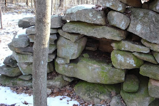
Split Wedged Rock
From the land east of Rt 495 just south of Rt 117: Closer:
 Sorry I did not get a side view. The wedge is a triangular piece of rock which is long and curved.
 Closer:
 Sorry I did not get a side view. The wedge is a triangular piece of rock which is long and curved.
Kentucky Stone Serpent
Geophile writes:
Someone brought this to my attention and I thought I should pass it along. Kentucky serpent
Someone brought this to my attention and I thought I should pass it along. Kentucky serpent
Saturday, February 27, 2010

Friday, February 26, 2010
Short Stretches of Stone Wall in Boylston MA
Went to Wachusett Watershed land in Boylston with FFC and it turned out to be one of the few remaining places with deeper snow, last weekend. There were a couple of short walls. This one down a valley: This one is coming off of a ridge making what looks like a funnel:
 But the view back down it lines up nicely with the rocks beyond:
 This one is coming off of a ridge making what looks like a funnel:
 But the view back down it lines up nicely with the rocks beyond:
NEARA Spring Meeting
NEARA Spring Meeting
16-18 April 2010, Kingston NY
Details later, or at the NEARA web page http://neara.org
16-18 April 2010, Kingston NY
Details later, or at the NEARA web page http://neara.org
Cairn reference in - The Rock-Art of Eastern North America
Norman Muller also writes:
Jannie Loubser pointed out to me an interesting comment on cairns. This is found in an article by Richard Edging and Steven R. Ahler titled "Rock-Art and Late Woodland Settlement in the Northern Ozarks," published in The Rock-Art of Eastern North America: Capturing Images and Insight (eds. Carol Diaz-Granados and James R. Duncan), Tuscaloosa (AL), 2004, 90-109.
On page 102-103 is the following under Cairns: "Rock cairns are an essential element in all of the site complexes documented on FLW (Fort Leonard Wood), and they are linked directly to Late Woodland mortuary ritual. Rock cairns occur singly or in clusters and are located almost exclusively on bluff crests and ridge spurs overlooking perennial streams (Ahler and Albertson 1996; Niquette 1986:19). Bluff crests were closen because bedrock was either exposed or accessible near the surface (O'Brien and Wood 1998:263), and perhaps their prominent and elevated positions on the landscape held ritual significance as well. Many cairns are located immediately above cave sites.
"In the early 1980s, Niquette excavated portions of 11 cairns across the installation (Niquette 1986; Niquette et.al. 1983). Remains of individuals were usually placed on bedrock, and stones were piled up to form a mound. Later burials may be placed at the periphery of the original mound, creating an accretional mound with multiple construction stages. Diagnostic artifacts found in the cairns include Late Woodland projectile points and Maramec series ceramics... While rock cairns have been viewed as functioning as burial places, the recovery of only secondary burials indicates that the cairns are only one portion of a more elaborate mortuary process. This is supportive of Hall's (1997) thesis that secondary or bundle burials represent a long process of mourning that binds the community together through time. Thus cairns were likely focal points for religious and social ceremonies in addition to being mortuary sites."
More reflections on rock piles by Johannes Loubser
Norman Muller writes:
"When tied to local/regional ethno-historic accounts, such as those collected by Mooney and others before him in the southeastern mountains, then interpretation of the production and use of stone piles and stone walls by the Native American Indians cannot be dismissed as speculation – in this part of the world these features were made to honor and communicate with the dead. Piles mark locations where the dead have fallen in battle. These battles were real and/or in certain cases were very likely terrifying vision quest-like encounters with spirit beings from the world of the dead. Subsequent visitors honored these locations by adding rocks and leaving trinkets. Walled rock enclosures and walls were used as vision quest blinds. Hard physical labor and physical effort was part of the spiel.
Below are excerpts from a message I just received from Johannes Loubser. From this message you will see that he is not a wild-eyed archaeologist, but one who looks very carefully at the archaeological and ethnographic evidence before coming to any conclusions.
Best wishes,
Norman
"When tied to local/regional ethno-historic accounts, such as those collected by Mooney and others before him in the southeastern mountains, then interpretation of the production and use of stone piles and stone walls by the Native American Indians cannot be dismissed as speculation – in this part of the world these features were made to honor and communicate with the dead. Piles mark locations where the dead have fallen in battle. These battles were real and/or in certain cases were very likely terrifying vision quest-like encounters with spirit beings from the world of the dead. Subsequent visitors honored these locations by adding rocks and leaving trinkets. Walled rock enclosures and walls were used as vision quest blinds. Hard physical labor and physical effort was part of the spiel.
"Out farther west, on the Columbia plateau for instance, rock cairns had a slightly different production and use sequence – either piled by successful vision questers to demonstrate the “burial” of their old status or piled by grieving family members to cover the remains of a dead relative. Abandoned pit houses, disused camas (a wild tuber-like plant) storage pits, and newly dug depressions served as vision quest blinds. Overall these were isolated locations, even if some occurred on previously occupied settlements. Again, physical effort to reach these places was part of the “self-sacrificial” spiel. So all-in-all there is no real mystery involved with these features; they merely reflect practices that sound and look weird to people who deny the validity of Native American Indian experiences, beliefs, and practices.
"Yet we also know of instances where Euro-American rock piles occur among Indian ones, a phenomenon that emphasizes that reality is messy and that each case should be evaluated on its own merit. In certain cases you do get agricultural field-clearing piles and construction stock piles, sometimes with live-stock pens and pasture walls, among earlier Indian rock features.
"In order for rock feature studies to become respectable I guess it becomes necessary not only to look very hard at the archaeological record but also at the archival ethno-historic record. Rigorous assessments are needed.
The association of cairns with rock art is also an interesting one (see attached jpg from an article by R. Edging and S. Ahler 2004. Rock-Art and Late Woodland Settlement in the Northern Ozarks. In C. Diaz-Granados and J. R. Duncan (eds.) pp.90-109. The Rock-Art of Eastern North America. University of Alabama Press, Tuscaloosa). Out west both rock art and stone piles are associated with vision questing. Evidence in the SE mountains seem to point at the likelihood that stone piles and nearby rock art are doorway posts to the spirit world access points on high-lying locales several miles upslope."
Niches in Mind
Reader Ted Hendrickson writes:
Recent visits to Gardener's Lake Chamber site and the Pike/Marshall preserve in Ledyard, CT has us wondering about stone walls and niches. On the shore of Gardener's Lake, just over the Bozrah town line is this chamber, reported on by many others. We decided to explore the area and came across some stone walls built off to the south of the road lining walls that lead to the site.
  They had the appearance of enclosures for animals, being squarish spaces with openings appropriate for gates. Noticed that built into them seemed to be purposeful niches.
 Or were they spots that stones had fallen out of or been removed?
 We weren't quite sure. These walls enclosed a space about 30 feet square with two openings. Interesting.
Last weekend we hiked in nearby Ledyard, CT, up a north-south lowland flanked by two ridges. Along the east side ridge we spotted this wall.
It ran roughly east west quite a distance in a pretty straight line, tall and single stone thick as it rose to the top of the ridge. As it hit the rock outcrop at the ridge edge, it stopped with a tall face and what appeared to be two niches built into this west facing terminus.
 The wall picked up again at the base of the rock face and continued across the wetland and seasonal stream, up the next ridge and terminated several hundred yards beyond into a swamp. Here is the niche face in the distance from the other side of the wetland up the other rise. You can see it in the center with the wall continuing below.

 The niches were positioned to face the setting sun, although the rays at this time of year fell a little from the south, perhaps the summer solstice would be a direct hit? Just north of the wall end was what appeared to be an enclosure that extended from the wall had stones running along the outcrop drop-off. Roughly triangular in shape, it too had an open view over the wetland to the west.
 A hundred feet north of the wall niches and enclosure was a propped boulder sitting on the same steep ledge with its open side facing the wetland to the west.
 We searched for any other signs, expecting to perhaps see some rock piles or cairns, but did not spot anything else, except perhaps a propped boulder (?) on the west ridge on the other side of the wetland.
 It is a nice area to hike with marked trails, but surrounded by development and some farms.
Any thoughts appreciated. We are trying to learn.
Recent visits to Gardener's Lake Chamber site and the Pike/Marshall preserve in Ledyard, CT has us wondering about stone walls and niches. On the shore of Gardener's Lake, just over the Bozrah town line is this chamber, reported on by many others.
 We decided to explore the area and came across some stone walls built off to the south of the road lining walls that lead to the site.
  They had the appearance of enclosures for animals, being squarish spaces with openings appropriate for gates. Noticed that built into them seemed to be purposeful niches.
 Or were they spots that stones had fallen out of or been removed?
 We weren't quite sure. These walls enclosed a space about 30 feet square with two openings. Interesting.
Last weekend we hiked in nearby Ledyard, CT, up a north-south lowland flanked by two ridges. Along the east side ridge we spotted this wall.
It ran roughly east west quite a distance in a pretty straight line, tall and single stone thick as it rose to the top of the ridge. As it hit the rock outcrop at the ridge edge, it stopped with a tall face and what appeared to be two niches built into this west facing terminus.
 The wall picked up again at the base of the rock face and continued across the wetland and seasonal stream, up the next ridge and terminated several hundred yards beyond into a swamp. Here is the niche face in the distance from the other side of the wetland up the other rise. You can see it in the center with the wall continuing below.
 The niches were positioned to face the setting sun, although the rays at this time of year fell a little from the south, perhaps the summer solstice would be a direct hit? Just north of the wall end was what appeared to be an enclosure that extended from the wall had stones running along the outcrop drop-off. Roughly triangular in shape, it too had an open view over the wetland to the west.
 A hundred feet north of the wall niches and enclosure was a propped boulder sitting on the same steep ledge with its open side facing the wetland to the west.
 We searched for any other signs, expecting to perhaps see some rock piles or cairns, but did not spot anything else, except perhaps a propped boulder (?) on the west ridge on the other side of the wetland.
 It is a nice area to hike with marked trails, but surrounded by development and some farms.
Any thoughts appreciated. We are trying to learn.
A note on building Rock Piles
Many sacred sites have a large number of almost randomly placed rocks on the surface that have significance but which are not built into noticeable piles. Coming along and trying to study the place, it would take some experience to even guess what might be important and what might be negligible. Placement of single rocks, not just rock piles, is very subtle. So, to build a rock pile there would be likely to destroy some of this subtle information.
Unless you know every rock there, you should avoid moving, adding, or removing anything from a sacred site.
Unless you know every rock there, you should avoid moving, adding, or removing anything from a sacred site.
Thursday, February 25, 2010
Being too judgemental
This has been a week where I have been being pretty judgemental. First we had Thorson and stone walls with litttle grasp of rock piles; then we had the South African archeologist giving an opinion about the need to investigate below-ground aspects of rock piles; and then I was being judgemental about the Indians in Ontario building a rock pile. Being judgemental about this last one seems to have gone too far. So I need to back off and apologize. I do not know what is in the thoughts of Indians in Ontario nor of those in New England.
Having been around the fringes of the public face of Native American culture (powwows, online bulletin boards, etc) I do know that they deeply resent people seeking out and imitating their spiritual beliefs. At the same time, I have walked the woods with some of the Narragansett and looked at rock piles with them and believe them when they professed ignorance. Maybe historically there is a pattern of deception and hiding of their beliefs that I am falling victim to. I don't think so, I think they honestly do not know about it [at least not the ones I talked to]. Take John Brown (the apprentice medicine man for the Narragansett). He talks about Nipsachuk as a place he remembers visiting as a child and talks about how he does not know anything about the rock piles. He is shown walking and standing on top of a cairn at Killingworth. Why not believe him when he says he does not know anything about rock piles, since he proves it by his actions? Why not believe the Ontario Indians also when they say they do not know the original reasons for building rock piles. Are they being deceptive? I am taking them at their word and at the same time am puzzled by a modern imitation of a past ceremonial activity.
So I feel guilty about being too judgmental in general and in particular about the Indians themselves; but I am going to stick to my guns in one way: we need to discuss these things. Native American belief cannot be a sacred cow that we dare not question on the topic of rock piles because it is simply not clear what those beliefs have to offer on the subject. No one has an inside track on what has been universally forgotten. To exaggerate the case, if I find a 7 thousand year old arrowhead, no one knows its history. My desire is to take that view for rock piles also, with the goal of understanding what is out in my backyard. If, at any time, someone reveals information that helps explain what is there, that will be very welcome.
Wednesday, February 24, 2010

"Rock Piles from a Comparative Perspective"
Norman Muller writes:
Jannie (Johannes) Loubser is an archaeologist and rock art expert, formerly from South Africa, now living and working in Georgia. I thought you might like to read this little article/statement from him.
[Quoted with permission. I hope we can have a discussion in 'Comments' - PWAX]
Rock Piles from a Comparative Perspective
Having had personally observed traditional rock piles in South Africa, Bolivia, the Dakotas, California, Oregon, and Hawaiʻi, it is clear that the identification and interpretation of rock piles is far from clear-cut. As in the piedmont and mountains of the southeastern United States, rock piles are often interacted with, modified, and even robbed, both by traditional peoples and modern-day developers. Conceptions of people who make the rock piles at times might also differ from archaeologists’ expectations.
Bantu-speaking agro-pastoralists in South Africa have an ancient tradition of stacking stones along trails, particularly at transition points on the landscape, such as within gaps of mountain ranges. As travelers pass a pile they add another stone in reverence to the spirits of the land. In the past farmers avoided these piles that occurred on the edges of their agricultural fields or blocked a jeep track going through the mountains, mainly to avoid damaging their plows and tractors. With heavier and better machines, however, these piles are increasingly being destroyed.
With improved technology farmers in the Dakotas have moved proto-historic stone tepee rings of the Plains Indians to the edges of agricultural fields. At least some of resultant rock concentrations on the edges of fields now resemble ancient rock piles, a phenomenon which, like crop-circles, has confused those avocational archaeologists who ignore anecdotal evidence.
In Bolivia elderly Quecha-speaking women living in valley-bottom farms annually scale a 3,000-foot high mountain peak to plant potatoes in honor of a female deity known as Pachamama. At this high altitude and extremely rocky terrain with hardly any soils, the women have cleared fields and created numerous rock piles and extensive terrace walls. None of the potatoes are ever consumed by humans. Ritual labor of this kind on marginal land goes against conventional wisdom as to the degree of effort geared towards non-subsistence ends and what qualifies as tillable terrain.
The lava flow landscape that characterizes the arid west coast of Hawaiʻi is another example of inhospitable terrain that stretched the imagination on how it ever could have been cultivated. Traditional Hawaiian cultivators piled lava cobbles that litter the barren landscape to create mounds in which they then placed mulch for the planting of crops, such as drought-resistant sweet potato. Yet other piles were cairns to mark a variety of features, including trails and boundaries between family-worked land-units. Rock piles were also shrines and in many instances covered discarded artifacts or buried human remains. Even the most extensive data recovery excavations cannot sample all the rock piles to determine what is within, so archaeologists have to act as monitors for developers when the ground surface is finally cleared for construction (by developing around burial locations, human remains are preserved in place).
Rock piles in states such as California and Oregon also need investigation prior to starting ground disturbance activities. Native American Indians of the American west are known to have constructed various vision quest cairns as part of their rites of passage. In many instances rock piles also cover human remains. As in Hawaiʻi, grave piles in the American west do not always take on a formal appearance; many are barely perceptible heaps that blend with the underlying talus slope or other types of rocky terrain. It is only the trained eyes of a very experienced observer that can examine a pile and perhaps observe water-worn rock or bleached bones within.
Overall then the message of this brief tour to other geographical areas is that a look below the surface is imperative; material remains and behaviors are not always what they appear to be on the outside. For this reason then it seems unlikely that relying solely on surface inspections or on our own pre-conceptions would yield conclusive answers; excavation of one kind or another, together with consultation of ethnographic sources, are currently the only ways to properly assess rock piles.
More on Opacum Woods - Sturbridge MA
Reader Mike H writes:
I was up in Opacum Woods this afternoon. At the top of a hill, there is a stonewall that has a quarter round enclosure with a radiusof about 12 feet. Directly south of this enclosure is a collection of 4 large boulders about 6 feet tall, with a stone wall connecting them to a rock ledge.
The first photo is looking west, there is a spring in the foreground starting underneath the wall, and heading south. The second photo is a view from the other side, looking NE.
 The third photo is looking south from about the same spot.
 The fourth photo is from the ledge to the south looking east.
I was up in Opacum Woods this afternoon. At the top of a hill, there is a stonewall that has a quarter round enclosure with a radiusof about 12 feet. Directly south of this enclosure is a collection of 4 large boulders about 6 feet tall, with a stone wall connecting them to a rock ledge.
The first photo is looking west, there is a spring in the foreground starting underneath the wall, and heading south.
 The second photo is a view from the other side, looking NE.
 The third photo is looking south from about the same spot.
 The fourth photo is from the ledge to the south looking east.
Hole in a wall - Opacum Woods
Reader Mike H from writes:
I found another wall with a squarish opening in it. It is in Opacum Woods in Sturbridge, South West of Opacum Pond. It is located less than 2 miles north of the Hole that was pictured in the entry from Oct 4, 2009. I am not sure what if any purpose these opening have.
I found another wall with a squarish opening in it. It is in Opacum Woods in Sturbridge, South West of Opacum Pond. It is located less than 2 miles north of the Hole that was pictured in the entry from Oct 4, 2009. I am not sure what if any purpose these opening have.

Sunday, February 21, 2010
Wetland next to site at Warren Brook
 If you look at the topo of the site at Warren Brook, there is actually a bit of wetland working its way around the back (lower left of the blue oval). There were several piles in there, smeared out, composed of quite large components. These include some of the "faint traces" I saw on first stepping into this area from above:
 Also a number lower down. Here the rock pile site is in the background:
 Other piles are in the foreground:
Warren Brook Watershed Conservation Land - Upton MA
 I walked in from a turnout on Grafton Rd, took the left hand fork, saw a large teepee off through the woods to the left but headed north off the trail and a ways over the flat snow; then increasingly eastward until I was walking to coming downhill and up to the edge of a shoulder. Saw a few traces of piles and then came to some nice "ski jump" marker piles at an overlook with a chambered cairn. This helped cement some of the ideas of "Wachusett Tradition" I wrote about last week.
A first look at the site, not sure it is a site:
 Note the little small boulder configuration to the left. I went to take a closer look:
 And the funny stone in the background.
 This reminds me of some rocks Mavor pointed out. What kind of role does that notch play? Functional? Representative?
Another view of the site:
 Details of the pile on the right:
 Rather than having a single vertical face, this pile comes to a point with two vertical faces.
A pile of a different shape, hard to make out in the snow:
 It is a small 1/4 acre flat place, with piles along its edge:
 And a nice view outwards to the east:
 Larger things - piles or outcrops with growth and rocks on top:
 Some smaller pointy piles:
 And perhaps now is a good time to come back to that small boulder configuration we saw at the start of the site. I was looking at it from the other side wondering, what that extra little extension was for.
  You can talk about "turtles" but look what is visible from the other side:
 The side surface of that small seems to me to be deliberately parallel to the surface of the larger one.
There was at least one other large pile with a vertical face:

Friday, February 19, 2010
The Other Stone Taxonomy
 I'm currently reading a borrowed copy of Exploring Stone Walls, by Robert M. Thorson (New York, Walker & Company, 2005), a book supplemented by this webpage: http://stonewall.uconn.edu/ExploringStoneWalls.htm.
In particular:
"•Stone Wall Science http://stonewall.uconn.edu/ExploringSWTerms.htm. This list of terms can be used to describe stone walls scientifically.
•Classification systems for stone Concentrations, Rows, and Notable Stones http://stonewall.uconn.edu/Classification.htm. These were not included in Chapter 9 - Classification for lack of space.
•A hierarchical list of the Complete Stone Wall Taxa http://stonewall.uconn.edu/ClassificationTaxa.htm for the more serious stone wall scientist. This is the whole taxonmy, using labels only ("Oh really?" - Tim).
•A printable version of stone wall science is List of key terms (.doc) used in the book arranged by category. If you have the book, use the index to locate where they are defined. "
I took a Rock Piles Post (Jacob Gates Lane Conservation Land, Harvard MA from Sept. 12, 2006) of a "stone concentration" and applied the above to it, plus my additional terms:
Condition (damaged or undamaged etc.): Well Preserved (8 on scale 1-10?)
Degree of order (stacked, dumped, or laid, etc.): Artistic
 Stone topography (boulder, slab, chunky): all of the above, as well as my additional descriptive terms, Testudinate; Carapace Stone Type: Scutes of Stone. Head, (Out stretched ) Forelegs, and Plastron.
Function (foundation, retaining, etc.): Sacred – Turtle Clan Effigy, Ceremonial, Memorial, and other possibilities.
Thursday, February 18, 2010
The Wachusett Tradition and Marker Piles
Since I coined the two phrases of "Marker Piles" and the "Wachusett Tradition", some discussion is needed about whether they are inter-related and, if so, what is that relation. I think there is some relation but the ideas are not identical. Let me explain.
A few weeks ago at the Hopkinton State Forest I noticed and described how the piles had a vertical face as well as a slanted or horizontal face that blended in to the hillside.

 I have always described this vertical face as a basic characteristic of what I called "marker piles". [It was Linda McElroy of Acton who first pointed out the vertical face on a pile at the "Acton Grid" but I stole the idea and gave it a name.] This type of pile has been discussed a lot on this blog [click here for some of the discussions]. So I won't spend time now talking about even spacing of rock piles or rock piles in a line.
But then, at Hopkinton State Forest, I noticed this other pile characteristic of blending in with the slope of the hillside. So a week after that, at Millers Hill in Holliston, seeing something like that I called it a "ski jump" profile [click here and scroll down]. This is frequently a characteristic of marker piles but not always. However Millers Hill and Hopkinton State Forest are slightly different - Millers Hill has a big platform and Hopkinton State Forest has smaller more numerous piles.Both have ski jump shaped piles. So these sites are similar but neither exactly fits the definition of "Wachusett Tradition": both sites have nice views - "outlooks"- but the chambered rectangular cairns are absent. Also neither of these sites is a typical marker pile site in the sense of numerous lined up piles.
Now, with a site I found last weekend in Upton at the Warren Brook Watershed Conservation Land, some kind of connection was seen: ski jump piles in intimate connection with a chambered rectangular cairn at a place with a good view. I will report that site separately but here are "ski jumps" from there:
 And here is a chambered (vandalized) and rectangular cairn from there:
 [Sorry the snow makes it hard to see but there is a rectangular hole at the center of the pile].
I think this is a significant overlap between one form of marker pile (the "ski jump") and the Wachusett Tradition of chambered cairns.
Let's return to the thought that these are not typical marker pile sites. The latter have, in the past, been places with many small piles, lined up and evenly spaced. But with these recent sites (Millers Hill, Hopkinton State Forest, and Warren Brook) the lines and the even spacing are not so evident, all that is left is the vertical face and the characteristic of blending in to the uphill slope. To be accurate, the Hopkinton State Forest site is almost halfway between a standard marker pile site and a Wachusett Tradition site - the piles are somewhat smaller and somewhat evenly spaced. Is it reasonable to think that Hopkinton State Forest is some kind of transitional site from a culture and thought process somewhere between the (older) Wachusett Tradition and the (newer) Marker Pile site? I say "older and newer" because the Wachusett Tradition sites are much more beaten down than some of the very fresh looking marker pile sites I have seen.
Is it reasonable to go even further and imagine a crude chronology that extends from Wachusett Tradition to Marker Piles with Hopkinton State Forest as somewhere between the two? It is too late for me to ask if this is truly reasonable because I have gone over into thinking this way. I don't know where Miller's Hill fits in and do not know if the absence of chambered cairns is more significant or the presence of ski jump shaped large piles there.
So, for better of worse, I have adopted a sense of chronology, a sense of a spectrum of types of site with older, larger, and especially chambered, rock piles more in the Wachusett Tradition and younger, smaller, more numerous, more lined up rock piles more in the Marker Pile style of site. Vertical faced piles remain present throughout. This spectrum is a result of my observation - classifications that arise from a long term examination of many sites rather than the immature "Rock Pile Types" I was seeing and describing a few years ago (see here) based on superficial characteristics of the piles. That is not to say I repudiate that earlier classification but rather that it is evolving and becoming more real and more observable place to place.
So, since I am provincial and locked into a Middlesex County MA study area, it begs the question: what is going on in other places outside of this small world? Most of the piles I see photos of, from further south in New England, seem like marker piles to me. Do chambered cairns at an outlook show up somewhere else? What about huge platforms like at Millers Hill? Where do they fit in and how common are they elswhere? Please let me know.
A few weeks ago at the Hopkinton State Forest I noticed and described how the piles had a vertical face as well as a slanted or horizontal face that blended in to the hillside.

 I have always described this vertical face as a basic characteristic of what I called "marker piles". [It was Linda McElroy of Acton who first pointed out the vertical face on a pile at the "Acton Grid" but I stole the idea and gave it a name.] This type of pile has been discussed a lot on this blog [click here for some of the discussions]. So I won't spend time now talking about even spacing of rock piles or rock piles in a line.
But then, at Hopkinton State Forest, I noticed this other pile characteristic of blending in with the slope of the hillside. So a week after that, at Millers Hill in Holliston, seeing something like that I called it a "ski jump" profile [click here and scroll down]. This is frequently a characteristic of marker piles but not always. However Millers Hill and Hopkinton State Forest are slightly different - Millers Hill has a big platform and Hopkinton State Forest has smaller more numerous piles.Both have ski jump shaped piles. So these sites are similar but neither exactly fits the definition of "Wachusett Tradition": both sites have nice views - "outlooks"- but the chambered rectangular cairns are absent. Also neither of these sites is a typical marker pile site in the sense of numerous lined up piles.
Now, with a site I found last weekend in Upton at the Warren Brook Watershed Conservation Land, some kind of connection was seen: ski jump piles in intimate connection with a chambered rectangular cairn at a place with a good view. I will report that site separately but here are "ski jumps" from there:
 And here is a chambered (vandalized) and rectangular cairn from there:
 [Sorry the snow makes it hard to see but there is a rectangular hole at the center of the pile].
 I think this is a significant overlap between one form of marker pile (the "ski jump") and the Wachusett Tradition of chambered cairns.
Let's return to the thought that these are not typical marker pile sites. The latter have, in the past, been places with many small piles, lined up and evenly spaced. But with these recent sites (Millers Hill, Hopkinton State Forest, and Warren Brook) the lines and the even spacing are not so evident, all that is left is the vertical face and the characteristic of blending in to the uphill slope. To be accurate, the Hopkinton State Forest site is almost halfway between a standard marker pile site and a Wachusett Tradition site - the piles are somewhat smaller and somewhat evenly spaced. Is it reasonable to think that Hopkinton State Forest is some kind of transitional site from a culture and thought process somewhere between the (older) Wachusett Tradition and the (newer) Marker Pile site? I say "older and newer" because the Wachusett Tradition sites are much more beaten down than some of the very fresh looking marker pile sites I have seen.
Is it reasonable to go even further and imagine a crude chronology that extends from Wachusett Tradition to Marker Piles with Hopkinton State Forest as somewhere between the two? It is too late for me to ask if this is truly reasonable because I have gone over into thinking this way. I don't know where Miller's Hill fits in and do not know if the absence of chambered cairns is more significant or the presence of ski jump shaped large piles there.
So, for better of worse, I have adopted a sense of chronology, a sense of a spectrum of types of site with older, larger, and especially chambered, rock piles more in the Wachusett Tradition and younger, smaller, more numerous, more lined up rock piles more in the Marker Pile style of site. Vertical faced piles remain present throughout. This spectrum is a result of my observation - classifications that arise from a long term examination of many sites rather than the immature "Rock Pile Types" I was seeing and describing a few years ago (see here) based on superficial characteristics of the piles. That is not to say I repudiate that earlier classification but rather that it is evolving and becoming more real and more observable place to place.
So, since I am provincial and locked into a Middlesex County MA study area, it begs the question: what is going on in other places outside of this small world? Most of the piles I see photos of, from further south in New England, seem like marker piles to me. Do chambered cairns at an outlook show up somewhere else? What about huge platforms like at Millers Hill? Where do they fit in and how common are they elswhere? Please let me know.
Wednesday, February 17, 2010
Short Stretches of stone wall - Warren Brook Upton MA,
Another scene from the Warren Brook Watershed Conservation Land on the Upton/Grafton line. A couple of pieces of stone wall: And viewed from the other end:
 Nicely built and all; this is not in any way broken down or ruined. What the heck were the builders up to? This is only superficially like a stone wall.
A few paces away, next to a brook:
 The ground uphill from the wall almost looks dug out. There were no other walls continuing the line of this short stretch. Again, what the heck is going on here? Maybe something to do with shadows.
This is a quarter mile north of the end of Oak Knoll Rd.
 And viewed from the other end:
 Nicely built and all; this is not in any way broken down or ruined. What the heck were the builders up to? This is only superficially like a stone wall.
A few paces away, next to a brook:
 The ground uphill from the wall almost looks dug out. There were no other walls continuing the line of this short stretch. Again, what the heck is going on here? Maybe something to do with shadows.
This is a quarter mile north of the end of Oak Knoll Rd.
Subscribe to:
Comments
(
Atom
)