Wednesday, April 07, 2010

Visit to Cheney Audubon Preserve part 3, April 3

Ted Hendrickson continues:

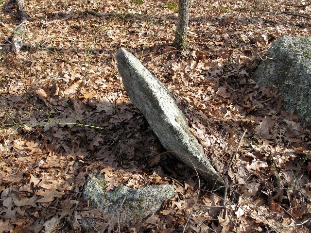
Descending the ridge and crossing the path I shot some closer views of the triangular standing stone from last week.
Continued on the trail past the stone cabin, foundations and root cellar/chamber (more on that another time). We came across some large piles/mounds that were associated with walls and bounded fields, kind of like the ones at the Perry Preserve in Stonington. Felt like field clearing to me.
Further along an intriguing pile on boulder with a piece of quartz in the center of the pile.Looping back along the path back toward the cabin a more dramatic mound came into view, accompanied by a smaller "satellite" pile on a slope. Well made and not associated with a close-by wall, these were more curious to me. Closer examination showed it had a flat top.
Both piles had been apparently disturbed and had depressions like someone had been digging into the piles? This is the uphill end of the larger pile.

Tuesday, April 06, 2010

Wetland site at foot of Jewell Hill, Fitchburg MA

I was going prowling north of Fitchburg and picked an evocative sounding place "Jewell Hill" to explore. Did you ever drive to Mt. Monadnock via Fitchburg and Ashburnam along Rt 12? As you get out of Fitchburg and into the higher elevations and are passing brooks, old farms, and woods, you may occasionally wonder what kind of land you are driving through. Chances are, if you are like me, not. So it was fun to realize my route followed this path and actually led off into that countryside, about which I was never curious. It is lots of up and down with lovely little hill farms and lots of stone walls. Take your in-laws there if you want to give them a taste of rural New England. Anyway, it was a day of driving and not seeing too much. But on the way to Jewell Hill, hanging a right from Rt 12 onto Jewell Hill Rd, just before the paved section becomes dirt road, there was a rock pile in the woods to my left. This was one of the places I figured I could use to access the hill and I ended up parking and walking in from there. From the road: A few steps further in:Looking back to my car, you can see how the piles sit along the beginning of a water course:This is somewhat typical of what you find in a wet "break-out zone", although usually there are also split-wedged rocks. For better or worse, I tend to think of this as a particular type of site - small potatoes compared to the major cairn sites, but still probably of interest. Pushing in further, a couple more substantial piles on slightly higher ground:(something about pairs?) And:Maybe that is the missing split-wedged rock? A few more on even higher:After that it was one foot in front of the other, up the hill. I did not see anything noteworth, except a pleasant view from the top: There actually was a bit or rock pile, to the lower right in the picture. It had modern additions to older lichen covered rocks. The panoramic view was impressive and I could just make out the Prudential and John Hancock buildings, 50 or so miles away in Boston. Back at my car: a last look, I could see that, along with the wetland to the left, the slope to the right also had rock piles:

Visit to Cheney Audubon Preserve part 2, April 3

Ted Hendrickson writes:

Went back to Cheney Preserve to settle some curiosity about the little valley area and to find the "large piles" we had been told about. The valley comes first as you approach from the road. Its presence was announced by some cairns on boulders along the trail that flank a small stream.

The darker stripe behind the cairn is the stream. This time the cairns led us to the lower end of the valley that travels roughly NW/SE with the southern end lower than the north. the concentration of piled rocks was still impressive on second inspection. The tall stack shown last time felt like it was at the focal point, the narrowest section flanked by the highest ridge and outcrop. Its in the center distance in this photo. The ridge just out of frame to the right is very steep. We ascended the ridge to the north for a better view. It had a dramatic bedrock edge at its summit and afforded a nice view of the valley below. You can see some of the structures on the valley floor.
Descending the ridge on the higher NW end of the valley we encountered many other piles. A view looking back down to the SE.
This may all be practical piling, but the area has a "feel" that it could be in response to the land forms.

Monday, April 05, 2010

Serpent Wall from N. Stonington CT

Norman Muller writes:

Last November Larry Harrop showed Bob Miner, my wife and me a serpentine wall in N. Stonington, one that Larry had seen before and posted images of it on his website. The serpent connection is undeniable. From the large rock pile or head, the wall ascends a steep slope to a narrow ridge, then turns left along the ridge for a short distance. The stonework near the crest of the slope has the intricate combination of large and small stones arranged in an artistic way that is (to me) characteristic of Indian walls . Along the latter portion of the wall I photographed Larry. At the end of the wall or snake were two niches, one on either side of the wall. This image shows one of the niches with a bottle in the background containing instructions for the sport called something like geocaching. This image shows another niche just to the left of the fern.

Tommy Hudson, a researcher from Georgia, made some comment about the N. Stonington serpent wall, but I can’t quite recall. Maybe Larry knows.

The Pliocene Pussy Cat Theory


I guess this is rock pile related:
The pliocene pussy-cat theory
by Lorenzo L. Love.
How else can you account for the Euro-centric explaination of a quarter million miles of stonework in NY and New England except with Improbable Research??????

Sunday, April 04, 2010

Small point from Lakeville

Chris P. had some good luck looking in a cornfield. Here is a find in its original context:This is a possible Hardaway Dalton:From an unknown type of material:

Saturday, April 03, 2010

Walls with Hollows

The woods in northern Upton, just south of the Mass Pike, have frequent examples of short walls that start and stop within 60 feet or 300 feet. FFC and I were wondering about how, maybe, they were meant to be seen from a distance. We also were wondering about shadows formed by the walls. But, in any case, sharp eyed FFC noticed some hollows at the ends of one of these short stretches of wall:
Here is a closeup of the end of the wall to the right in the above picture (sorry about the blur):
This reminds one of the current hypotheses about hollows: they are either as a place to sit, a remnant of a collapsed space, or where someone dug a hole.

In the example above, FFC thought there were hollows at either end of the wall. I want to mention this as part of the context of the general discussion about hollows in rock piles.

New trails feature mysterious stacked stones

From the Saturday Gazette-Mail of West Virginia - about the Stonewall Jackson State Park cairns. [Click here] I think the Gage's may have surveyed that site.

It is frustrating to read the "officials" floundering around with no context and awkward attempts to explain things. They are all like "We may never know who built these....". My hope is that this confusion would pass given adequate mapping and better archeo-astronomy and/or more serious dating efforts.

Friday, April 02, 2010

Along Falulah Brook

Driving slowly by, seeing rock piles in the shrubs next to a brook. We stopped and parked. and went in to see this pile:Another view:The brook is called Falulah Brook and it is in Fitchburg, not too far from Wright's Ponds where I sketched this similar shaped and similar sized pile: That one was also next to a body of water as reported here. You may recall I have been pursuing "rock piles with tails" in the northern parts of Fitchburg - the northwestern part of Middlesex County, and following the idea that they are found more next to water. This has turned out to be a pretty good hypothesis and so it is tempting to see the rock pile next to Falulah Brook as another confirmation. On the other hand there is enough stuff along the brook that is mill-like to suggest caution. In terms of the "tail", on these examples the structure looks more like a space missing from pile, more akin to a hollow. On the other side of the street, a bigger smeared out pile:This is such a mess it is foolish to speculate about. But that apparently doesn't stop me. I am embarrassed by the voice over, but it is worth it to show you the pile. :

Then I poked around in the vicinity, seeing some things that are distinctly Native American:
And a few feet down the brook, following a dirt access road, I came across truly big game:It is a big mound with a collapsed inner chamber or remnants of a hole someone dug in the front. Here is a side view:A few feet further down the brook, another large mound. But a bulldozer has been right through it:This pile had two hollows in it, one with some fresh damage and maybe caused by the bulldozing, another on the back side with the same moss cover inside the hollow as on the pile - a much older hollow.

There had obviously been some bulldozing here and down at another crossing of the brook. Possibly the water management people (since this is part of the Fitchburg Reservoir land) had cleared an obstruction or something. It was starting to look pretty bad:
So I pretended to not see this and did not look too carefully; then reversed course. Probably I should have continued down the brook to see if there were more mounds along it.

Because of all this modern activity, it is harder to argue that this is a pristine Native American site, or even a Native American site for that matter. With the brook being a potential energy source for the mills (it shares a name with the Fitchburg Falulah Paper Company), and not knowing what mill ruins look like, it is not a clear picture to me. Given my bias, I am going to go with the initial comparison of the first rock pile, mentioned above, and the rock piles at Wright's Ponds a couple miles away in Ashby. So there are at least some Indian mounds here. The really interesting question is whether the large mounds are from the same time period/culture as the smaller ones. We are, after all, talking about mounds with hollows, some of them 10 across and others 30 feet across. For my money, the small piles are older.

I also think these hollows look like tails. Maybe there is more than one kind of tail on a pile: one kind being the vestigial remnant of the edge of a hollow, another more deliberately built as a wall jutting out from a rock pile. I also am wondering if these "mounds" might not have served several different death-related, mortuary, functions - some for the preparation of remains and others for the housing of the remains. For example, on one tail in Carlisle, the rock at the end of the tail was flat and level and looked like it had been burnt.

Returning towards the car, spotting another small mound part way up the hillside:Closer:
Most of the arguments about how the mounds along Falulah brook have to be bi-products of one or another type of practical,mill-related activity, are contradicted by this other pile twenty yards up the hillside. There is no mill activity up there, just walls and a few other decrepit piles:Here is the view back towards my car:Aside from the particulars of this Falulah Brook site, there are reasonably similarities with the site at Wright' Ponds; enough to consider this part of the same "Wachusett Tradition" - a product of the culture I have been tracking from Apron Hill in Boylston to Woodbridge Rd in Carlisle and back to northern Fitchburg. But now with these large mounds we have a connection to something slightly different. I have seen big piles like those somewhere else related to Wachusett, in particular in the Manoosnoc Hills of Leomonister. And finally this is getting close enough to Muddy Pond in Westminster to add this to the collection of places under discussion.

Update: I went back to look at this site and cannot convince myself this is ceremonial. There were some gravel/sand borrow areas that might have left rock piles behind. So I just don't know.

Spring Cleaning in the Chickenyard

Spring Cleaning in the Chickenyard