This is about rock piles and stone mound sites in New England. A balance is needed between keeping them secret and making them public. Also arrowheads, stone tools and other surface archaeology.
When else was I going to get anything like a genuine "Great Plains" experience?. Planning to visit my son in Boulder I spent weeks pouring over maps and aerial photos trying to decide where we should go look for arrowheads.
Found the perfect spot: next to a major creek (Howard Creek), on public land (Pawnee Grasslands National Park), and signs of past plowing - with long straight lines from industrial scale plowing overlaid on curved lines from manual plowing. So the ground will have been churned. I zoomed in on a destination (up CR77 from Briggsdale, between CR96 and CR100 - figured we could pretend to be bird watching, if deception was called for) and, to my delight, spotted a marking on the map: "Arrowhead Windmill". Seemed just right.
Drove out that way (~100 miles from Boulder), getting to chat with my son, we finally arrived and stepped out. The ground was covered with chips:
Mostly chalcedony (a form of SiO2, different from quartz in its flaking properties) and jasper. We did not find arrowheads but scrapers and worked edges.
Top to bottom: a scraper made of jasper (metamorphosed chert); a chalcedony working edge; a bit of a 'hatchet' made of chert [??].
Nothing too cool but we only spent two hours out looking around. Honestly these were the most confusing things I ever looked at. At first things looked like debris, then I noticed working edges and differential polish. None of it made any sense. Perhaps the smaller items were multi-purpose.
Worth the 100 miles just to be there:
I get a laugh, zooming in on this one. Where else could you pee and scan a horizon like that?
A bit later, we walked over to Arrowhead Windmill. The water tasted a bit chalky, there were no arrowheads underfoot, but there was a bit of a structure I did not understand:
These were the only rocks visible on the surface.
That was at the very edge of the grasslands. There is un-restricted camping throughout [in most of the Boulder area you can see nature only through a barbed-wire fence] so it would be fun to go deeper in, finding better wetlands, and spend a week basking in the emptiness.
According to the Denver Museum of Nature and Science, this is a piece of rock crystal. I have a hard time believing it. Maybe it is SiO2 crystal but forged, not natural.
Both Mr. Merriam and Mr. Webster agree that Pareidolia (per-ˌī-ˈdō-lē-ə -ˈdōl-yə) is: "The tendency to perceive a specific, often meaningful image in a random or ambiguous visual pattern. The scientific explanation for some people is pareidolia, or the human ability to see shapes or make pictures out of randomness."
But what do you call perceiving meaningful intentional repeated visual patterns????
A triangular flat topped boulder,
Chosen perhaps because of the suggestion of an eye,
In just the right place, in order to appear as a Big Stone Snake???
A diamond shaped stone, seven scales back,
Can sometimes be another repeated pattern,
Another important stone, perhaps fallen, whispers:
"Possibly the Crystal," but one just can't say for sure...
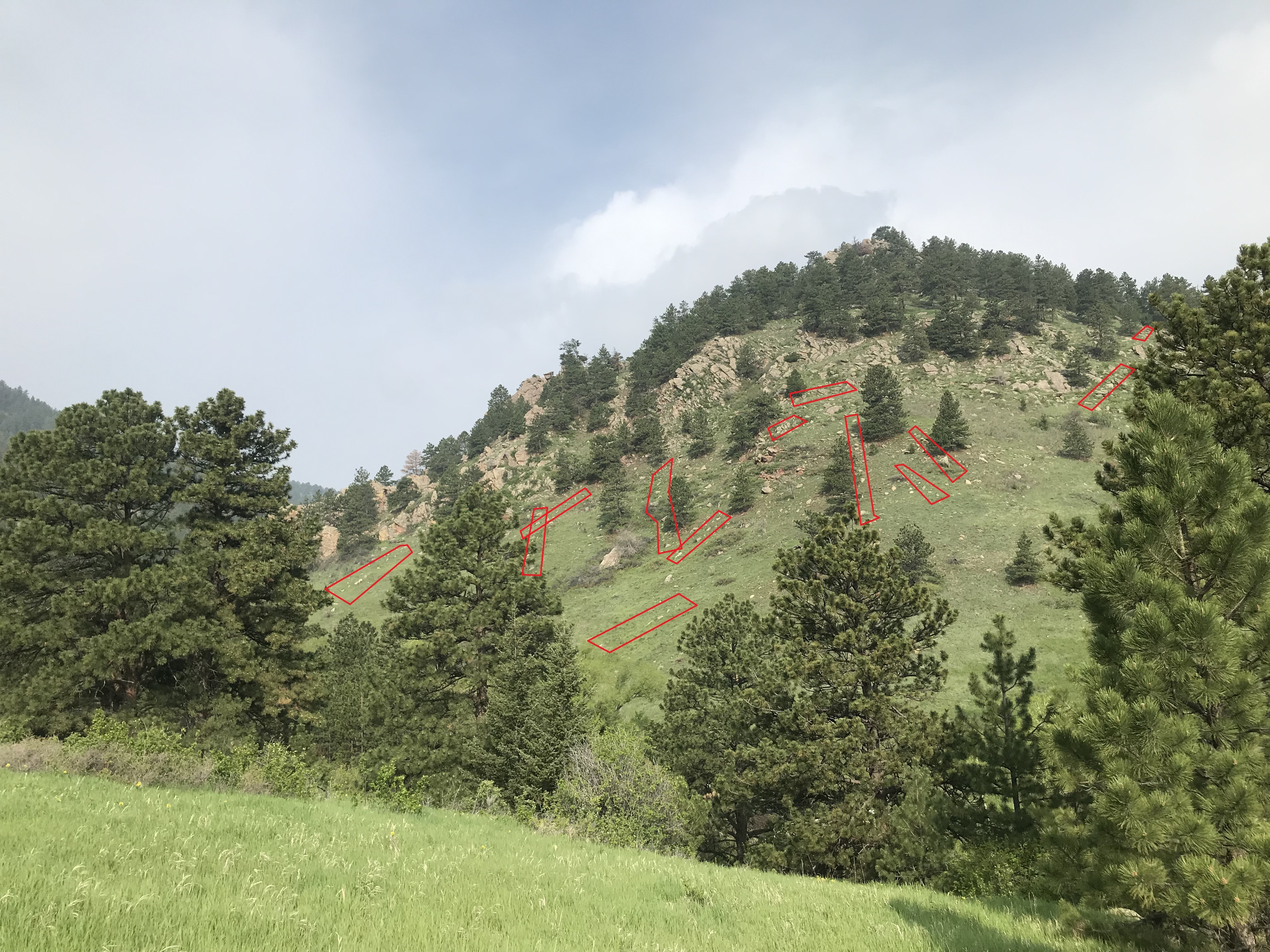
Consider this slope, which I believe has several deliberate stone lines, forcing game to climb the slope along specific routes.
Here are some possible rows of lined-up rocks I can see in the picture. Some of them might be natural outcrops but "four in a row" (when they are adjacent rocks) makes it statistically unlikely that they are random. You have to look very closely.
The stone rows are loosely defined. It is easy to imagine a hooved animal preferring to step on grass rather than rock. So a stone row would cause an animal to make a choice between sides of the row to walk along. So the slope is covered with binary "gates" running upward and converting the continuum of choices into finite possibilities.
This would allow for a very flexible trap control system- depending on the wind conditions. Imagine a few runners chasing game uphill towards predictable places above, where hunters with spears waited! Today, you can see places on the hillside where the grass is growing longer, and other places where the grass is short and flattened down. The animals are still using the paths and the hunters are long gone.
I bet there are arrowheads up there. For reference, this is the slope right across from Chatauqua Park, between the Flagstaff and Crown Rock trails.
Noticing out-of-place rocks and non-random rock arrangements are visual skills that are helpful for looking for rock piles here in the East. When I go hiking out West, these skills automatically kick in and I notice things that, in the end, seem closely related to animal "flow control" and hunting. It is easy to infer a practical significance to the western structures and this makes me wonder if some of our eastern ones might have a practical function we are not aware of. In any case, skills for finding rock piles are related to skills for finding arrowheads - or at least for finding hunting sites.
Let me give a few examples. In Nevada I explored a hill looking for arrowheads, found barely visible rock piles, and learned something interesting about how hunting worked at this site. In the Boulder area of Colorado, I noticed many subtle stone walls arranged on hillsides - making funnels, blocking off spaces, and covering the entire slope in such a way that they might work differently in different wind conditions. I see on YouTube that animal "funnels" are a good place to find arrowheads but it is hard for me to get to the top of a steep slope (just like the poor animals that went that way) and, in eastern Colorado, there is enough topsoil that you would have to excavate to find arrowheads - or get lucky with the erosion.
I have written a bit about Nevada here and here is a link to one of the sites from Colorado. If you are impatient, take a very close look at this slope just north of the "Flatirons".
Register HERE. Acton Memorial Library: Thursday, May 11, 7:00-8:30 pm
Author Dan Boudillion will discuss his just-published book on the history of the Nashobah Praying Indians from the 1654 establishment of Praying Indian Plantation to their sufferings during King Philip’s War and exile on Deer Island, then to the loss of their lands in 1736. The Nashobah village was one of the 16 “Praying Villages” established in Massachusetts in colonial times and included essentially all of modern Littleton. However, part of Acton was, and still is, on Nashobah Praying Plantation land! Dan will share how the book came to be, and fascinating stories of the Nashobah Praying Indians who are still alive and a presence more than 350 years later. Books will be available for purchase and signing at this event, as well as on amazon.com.. In-person only.
He approaches a small boulder of quartz, sitting out-of-place on the forest surface. He examines bits of debitage and discusses the properties of quartz. It is out-of-place too. Evidence of both ceremonialism and practical life.
You could say the guy is living in the present. But with "bushcraft" in the title, I thought he was at least going to make sparks.
Central Washington University, romansjakien@gmail.com
“Obtaining power through features on the landscape and
stacking rocks were prominent aspects of their traditional religious practice
(Deur 2016; Haynal 2000; Ray 1963; Spier 1930; Theodoratus et al. 1990). Deur
(2016:36) notes that in Klamath and Modoc oral tradition, the act of stacking
rocks during the vision quest is “attributed to the very beginnings of human
time, and is rooted in the instruction of the Creator, Gmukamps.” Ray
(1963:xiii) noted that the two tribes not only created “artificial rock piles
for religious and commemorative purposes” but also “attributed mythological
significance” to naturally occurring rock piles…It has been written that
certain rock feature types, like “rock stacks” and “prayer seats” are sometimes
positioned at specific geographic locations that align them with distant
landscape features such as mountains, lakes, and rivers (Jankowski 2012). Deur
(2016:52) suggests that ritual rock features are sometimes aligned with distant
landmarks so that prayers can be focused towards those places, or powers
obtained from those landmarks. He also suggests that some landmarks have
stories or moral lessons associated with them that can be incorporated into
ritual activity or prayer. The importance of visualizing a distant landmark for
certain ceremonial purposes explains why many vision quest sites are found at
higher elevations with open viewsheds (Applen 2001; Jones 2003)…
Deur
(2016:56-57) states that the “practice of ritual rock stacking is said to have
skipped a generation in many families” due to the assimilation policies and
tribal termination, but that there has been a “reawakening in recent decades.”
Information gleaned through recent ethnographic studies indicate the practice
of constructing rock features in traditional Klamath and Modoc lands continues
by current Klamath tribal members, even with the conversion of many to
Christianity or secular belief systems (Deur 2016; Haynal 1994, 2000)…”
Jakien, Roman, "Rock Features of the Upper Klamath Basin: An Integrated Approach to Identification"
(2018). All Master's Theses. 892.
Some eclectic finds, from a town with a sense of the past. A special place for Americans. What I never realized about Plymouth before is that it was as very hospitable place, with a welcoming topography.
The most recent prehistory of the town is oriented towards the Wampanoag. These items suggest a deeper past.
Going through some old photos, I came upon this image of a large cairn supposedly somewhere in Berks or Bucks Co., PA. What I found interesting was the stone enclosure at one end. That reminded me of an enclosure I had photographed in Westkill, NY ages ago (0097). And then I remembered another small enclosure at one end of a large cairn, also in Westkill. The enclosures look like sacred spaces, perhaps to leave offerings.
Archaeologists have been studying the monumental earthworks in the eastern woodlands since Thomas Jefferson first tasked a few of his slaves with excavating one in order to determine if they were built by Native Americans or not. Here I very briefly review what we know about the process of monumentality in the Southeast over the course of 6000 years .
Sunday April 23, 1:00 pm – 3:00 pm, Littleton Historical Society, 4Rogers Street, Littleton, MA
History of the Nashobah Praying Indians: Doings, Sufferings, Tragedy, and Triumph
Please join Strong Bear Medicine and Quiet Storm of the Nashobah Praying Indians at the Littleton Historical Society building on Sunday April 23 for an open house celebration of the newly released book: History of theNashobah Praying Indians. Meet and mingle with Strong Bear and Quiet Storm, and author, Littleton historian Daniel V. Boudillion. Have your books signed, partake of refreshments, and enjoy Native music.
This is the third piece of glass I picked up since last fall because of the signs of deliberate flaking. I have a very hard time believing anyone would make a working edge out of a piece of glass but the signs of deliberate, organized, serration along the edge are unmistakable. (Although hard to photo.)
I find it beautiful in its own way.
I still can't get over how poor you would need to be to not be able to buy a knife.
From what I can see, this was happening a lot in southern MA and RI. It re-enforces the idea, applicable to rock piles, that the ancient dissolves into the modern. Less poetically, Native Americans in southern New England (and probably other places) retained some traditional technologies long after you would expect.
A small site, where the crosshair appears on this map
Or, in the blue outline
This is a small conservation land, a bit hard to get to. I walked there from behind the Chappaquoit Bar and Grill.
Here, a small neck of land is divided by a stone wall running north-south along its midline. A strange place for a wall but there were signs of boulder quarrying and other, presumably modern, activities. On the east side of this wall, were cedar trees - growing back into what had been an open field. But on the west side of the wall was a tangle of brambles and boulders. Sure enough, following the trail brought us past a rock pile:
I would not have thought an isolated pile was worth recording but, soon enough, some other minor structures appeared in the bushes.
This looks like a small ceremonial. Or it is just a damaged pile.
Here is the prospect:
There were several rock-on-rocks.
People wondering what defines a Ceremonial Stone Landscape. It should be clear with such a cluster of small "pointless" piles, all in one spot.
I came across an excellent documentary on Youtube: "Standing with Stones: An Epic Journey through Prehistoric Britain and Ireland." The documentary is 2.25 hrs. long, but the story is so fascinating, the photography superb and the commentary by Rupert Soskin intelligent and spot on, that the two plus hours go by quickly. Soskin is part of a group called "The Prehistoric Guys," and they have produced a number of films/documentaries under that heading.
I wish I felt it was possible to have an open discussion of stone tools, without having to justify their existence to people who don't recognize organized flaking, or to justify the ideas in terms of conventional US archeological timelines and vocabulary. I would like to simply look at the data available - the tools themselves.
My problem is mostly that I cannot find referents to some of these items using US terminology. If I say something looks "Solutrean" or [worse] "Mousterian", then this is open to a certain reasonable ridicule. In any case I have no basis for assigning age or chronology to any of the tools I've been posting. I may want to use the phrase "pseudo-Mousterian", or some such, to get around the prohibition against such concepts being applied in America.
Here at home with only rocks to look at, it is surprising how many details emerge from inspecting their edges and surfaces. I can't help thinking things look old.
"He was able to identify the curious piece as a “Great Basin crescent.” Joe told me they were extremely rare and are found only where the water level of ancient Lake Lahontan was between 7,000 and 9,000 years ago."
Most researchers on hominid evolution, looking back into deep time, ask what function or use an object would have served archaic communities in their struggle to survive. However, as previously noted, this utilitarian assumption is questionable. An alternative assumption is that the deep past may not have been like the present, dominated by the overtly utilitarian values that have always existed but have become dominant in modern Western civilization. I suggest that early humans possessed a sense of the sacred; that they were soulful people with hearts and minds who loved—and also presumably feared—the Earth on which their lives depended, and within which their lives were deeply embedded. These are essential attributes and qualities that make us human yet remain beyond the grasp of science where the question of “soul” and “the sacred” was driven out ...
The Nolumbeka Project is co-sponsoring and/or participating in the March offerings listed on the EVENTS page of our website. We will have more announcements as the months progress. Meanwhile, please mark your calendars for May 20 for the Day of Remembrance and August 5-6 for the Pocumtuck Homelands Festival.
Attracted by the name, I have tried a couple times to get into Arrow Canyon. This time I was careful to find the correct dirt road, taking me down into the canyon. Google street view of NV168 was helpful, cuz those dirt roads all look similar at their beginnings. I drove till it got too muddy, parked, and then started edging along the sides of the canyon, as I got deeper into it. There was an old stone house - no roof - near the beginning of the canyon, then some wild gourds or melons ...
... , then gravel slopes tumbling off the caprock, then some Ogham scratched in the Canyon wall, then a stone chamber, then a solid dam across the canyon. My guess is this dam was to prevent flash flooding downstream. Anyway, the dam was a barrier. There was a helpful rope for people to climb but that is not my idea of fun. It was getting late, so I turned back at the dam.
Here is a view of the dam and the, still unseen, deeper valley:
Anyway, the first gravel slope (a "talus slope") had some chalcedony ("cal-sed-ny") flakes and that was about the only arrowhead-hunting encouragement I got. (Well, I should mention this:)
So, I am walking down the left (east) edge of the valley. At the first talus slope, spilling into the valley from the left, I see an opportunity to get up to the cap rock (about 100 feet up) and I scrambled up there, one slow step at a time. Getting up to the cap rock, I walked out to a little peninsula, then started getting dizzy and had to back off. But one notices this little line of rocks and rock piles:
If you are familiar with alignments, you may spot this. Most people would just see rocks.
While on the subject of spotting out-of-place rocks, this stopped me as I exited the canyon by car:
You see: there are a few too many rocks of the same size, propped up a bit too non-randomly. I got out and looked at them, They formed lines - sometimes lines that crossed at a single rock. All the lines pointed off somewhere towards the southeast - including the ones from earlier, up on top of the mesa.
So that was the NEARA trifecta: stone chambers, manitou stones, and alignments. As a nod towards NEARA's epigraphic roots in ESRA, we got a bonus feature: some Ogham (Oggam) writing. It is so amusing because - yeah - I see the mystery but I have no skin in the game. I'll leave you with this:
Let me tell you my story about going to Nevada. It is not rock pile related although, in truth, there were rock piles on top of each of the only three prominences I got to. No, I went to find arrowheads. I didn't find any but I did see an awful lot of thought provoking archeology. I am sure the place I visited is not particularly special and there must be many, many places like this. But in some ways it was special and, at the end of this story, I will show why I believe this may be one of the more densely occupied sites in the valley. It is called "Hidden Valley" and is just north of Las Vegas on I15, on NV93.
For the last three or more years of the Covid pandemic, I have been sitting at home dreaming about visiting the southwest desert. And looking at maps and pictures. For a long time I was looking at cheap real estate pictures from near Saint Johns, AZ but no one in my family seemed very warm to the idea of buying land there. Then, more recently, I became crazed about finding arrowheads. So I was watching YouTube's about people finding long stemmed points around glacial lakes in the Great Basin - and I thought maybe I could give it a try.
One video was about excavating Haskett points in Great Salt Lake and it said that the best place to look for archeology was where fresh water entered the lake, when the climate was beginning to dry out after the ice age. It also gave clues as to what the old water courses would have looked like in satellite images. So I am looking at satellite images and topo maps and locating the glacial lakes near Las Vegas. One problem that suggested itself, is that many of the lakeshores from the late ice age appear to be completely buried under a deep outwash from the adjacent hills (called the "bajada", according to my friend Dave). It occurred to me that small hills at the edge of the lakeshore, even if surrounded by the bajada, might retain original surface and not be covered with silt. So I spotted something on the topo map that looked just right: near Las Vegas, edge of glacial lake, small hill within the lake AND not in a National Park where it could be illegal to pick up even "just a rock" items. I thought I was being quite clever to spot this place and plan to visit:
You may have to click in to see it but the crosshair is along NV93 at a place where a dirt road heads west for a couple of kilometers, where it stops at the back side of a small hill that met all my criteria.
So I planned a trip out there and finally arrived. This is the drive, the next day in passing the place:I tried to drive in on the indicated dirt road but came to a washout. Don't get me started on the experience of 4WD and dirt roads. It is not my idea of fun but I had rented a Toyota Highlander - a fine vehicle - and took no chances. I walked in the final 1/4 mile.
You can hear a bit of wistfulness in my voice here. I went through a lot to get to this spot - now what? I have come a long way to take a chance on this place and am a bit scared of the desert. You have to force yourself to get out.
In the second half of the video, I am looking at the scatter of flakes and debitage on the ground. It was really only when I got back home when I realized this ground could not have been underwater when people broke rocks here. Which is one of many different factors contributing to my overall confusion about the date of the site(s) on this hill and its flat surroundings. I spent two days exploring this hill in the desert, wishing I could find a glacial lakeshore. And that is exactly where I was the whole time!
I saw lots of nice pieces of broken rock and collected a few stone tools. I'll do them more justice later. Here is the most exiting thing I found.
The idea that I might find something like this - unbroken - has me wanting to go back and try again. Even half a day of exploring exhausts the neurons and you can see why - a very intense 'needle in a haystack' situation. Maybe next year.
So I walked around for one day. The next day I went north, then east on NV168 to a dirt road into Arrow Canyon. This was a different kind of place and perhaps of more interest to NEARA members than to arrowhead hunters. Some of the archeology up on the cap rock there seemed stunningly old, compared to everything else I have seen. More later on that.
The third day, I had company from my friend Dave. We tried the little hill on the east side of NV93 and then spent most of the day back at the little hill. I did not find any more nice suggestive blades but we had a lovely chat.
The trips out and the trip back were exhausting. I got home, unpacked my finds, took a shower and went right to bed. Two days later I am still hydrating, napping, and thinking about it all. The worst moment on the way back was when the lady in front of me went through security and had to have her bag searched. She was asked: "Is there anything sharp in your bag?". When I heard that, I started thinking about the stone axes I had in each coat pocket. I was not going to let them take those away at the airport! I put on a cheerful face and they overlooked the possibility of sharp objects in a coat pocket.
I should mention that the bedrock here, north of Las Vegas, is volcanic [or marine?]; with layers of ash and nodules of chert. Sometimes the chert is in complete layers with colors ranging brown to reddish. Exposed to the air, it becomes increasingly black with desert varnish. There is a an earlier post about the material. What turned out to be quite lucky was that the little hill I picked from here in Massachusetts, happened to be made of one of the chert layers. Now that I am back in Massachusetts I am realizing that the hill itself was a good source of material for making stone tools.
I was thinking some more about those patches of chert debitage, black from desert varnish. And it occurred to me that perhaps they might be visible in the satellite images. They are (and here I am going to tell you one key to unlocking desert archeology. If you've read this far, then you deserve to know this:) You can see every site in the entire valley by spotting the darker patches of lithic debris in the satellite images. What do you know?! My little hill has the darkest patch of all. But I can see some other places that have concentrations.
Here, then, are some things we can learn.
The hill is shown from above as a darker brown oblong running from south-southeast to north-northwest. It is a chert outcrop. There is a stone 'U' and a rock piles on the southern and northern summits. Let's notice the game trails from left to right. These cross the hill at a slight saddle between its summits. I was thinking: why would an animal not go around this hill? [Stubbornly it insists on going straight towards whatever destination it has in mind but - poor animal - when it crosses the hill, going downwind, it is likely to encounter hunters on the downwind side.] Look how the hunters have left a black crescent of debitage around the southern foot of the hill. Look how they left concentrations just next to the game trail outlet. This is fascinating: the debitage is a heat map. It is a guide to the whole valley.
Now I am at home, looking at my finds. It was a very stimulating trip. I wish I had some graduate students to help with some of the obvious experiments. There were many different tool types and even differences in how little micro-blades were retouched or not, before use. I would think equating desert varnish color could be calibrated to OSL dates and that rather than the different styles and ages and locations forming an entire cacophony [what I am calling it] that, instead, we could start teasing it apart. Meanwhile, I keep thinking about butchering a camel.
If you want to hear me get carried away with the subject of lithic analysis, see here.
These lucky fellows got the chance to count stone tool debitage and found an average of 75 modified fragments per square meter. I think that quantity could be matched pretty easily in some places in Nevada.
This lucky guy (me) didn't count flakes but each little piece of black rock here is a bit of chert from the nearby small hill:
I did not look carefully until I sat down to talk on the phone. And while I am on the subject, can you imagine spotting a small arrowhead made of the same material - in this cacophony!

.JPG)


.JPG)